Devault, Pennsylvania

Last updated
Devault, Pennsylvania
Unincorporated community
USA Pennsylvania location map.svg
Red pog.svg
Devault
Usa edcp location map.svg
Red pog.svg
Devault
Coordinates: 40°4′28″N75°32′7″W / 40.07444°N 75.53528°W / 40.07444; -75.53528 Coordinates: 40°4′28″N75°32′7″W / 40.07444°N 75.53528°W / 40.07444; -75.53528
Country United States
State Pennsylvania
County Chester
Township Charlestown
Elevation
344 ft (105 m)
Time zone UTC-5 (Eastern (EST))
  Summer (DST) UTC-4 (EDT)
Area code(s) 610 and 484
GNIS feature ID1173189 [1]

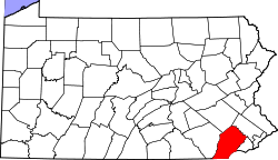
Devault is an unincorporated community in Charlestown Township in Chester County, Pennsylvania, United States. Devault is located at the intersection of Pennsylvania Route 29, Phoenixville Pike, and Charlestown Road. [2]

Climate

The climate in this area is characterized by hot, humid summers and generally mild to cool winters. According to the Köppen Climate Classification system, Devault has a humid subtropical climate, abbreviated "Cfa" on climate maps. [3]

Climate data for Devault, Pennsylvania
MonthJanFebMarAprMayJunJulAugSepOctNovDecYear
Average high °F (°C)37
(3)
41
(5)
50
(10)
61
(16)
72
(22)
80
(27)
85
(29)
84
(29)
76
(24)
65
(18)
52
(11)
42
(6)
62
(17)
Daily mean °F (°C)30
(−1)
33
(1)
41
(5)
51
(11)
62
(17)
70
(21)
76
(24)
74
(23)
67
(19)
56
(13)
44
(7)
35
(2)
53
(12)
Average low °F (°C)22
(−6)
24
(−4)
32
(0)
41
(5)
52
(11)
61
(16)
66
(19)
65
(18)
58
(14)
47
(8)
37
(3)
28
(−2)
44
(7)
Average precipitation inches (mm)3.8
(97)
2.8
(71)
3.5
(89)
3.6
(91)
4.5
(110)
3.8
(97)
4.2
(110)
3.4
(86)
4.3
(110)
3.2
(81)
3.4
(86)
3.3
(84)
43.7
(1,110)
Source: Weatherbase [4]

Related Research Articles

Chester County, Pennsylvania County in Pennsylvania, United States

Chester County, colloquially known as Chesco, is a county in the U.S. state of Pennsylvania. As of the 2010 census, the population was 498,886, increasing by 5.2% to a census-estimated 524,989 residents as of 2019. The county seat is West Chester. Chester County was one of the three original Pennsylvania counties created by William Penn in 1682. It was named for Chester, England.

Coatesville, Pennsylvania City in Pennsylvania, United States

Coatesville is a city in Chester County, Pennsylvania, United States. The population was 13,100 at the 2010 census. Coatesville is approximately 39 miles west of Philadelphia. It developed along Lancaster Turnpike, beginning in the late 18th century. It spans U.S. Route 30, the "Main Line" highway that runs west of Philadelphia.

Downingtown, Pennsylvania Borough in Pennsylvania, United States

Downingtown is a borough in Chester County, Pennsylvania, 33 miles (53 km) west of Philadelphia. As of the 2010 census it had a population of 7,891. Downingtown was settled by English and European colonists in the early 18th century and has a number of historic buildings and structures.

Exton, Pennsylvania Census-designated place in Pennsylvania, United States

Exton is a census-designated place (CDP) in West Whiteland Township, Chester County, Pennsylvania, United States. Its population was 4.9k at the 2010 census. The Exton Square Mall and Main Street at Exton are both located within Exton along with several other shopping centers, making Exton the major shopping district in Chester County.

West Chester, Pennsylvania Borough in Pennsylvania, United States

West Chester is a borough and the county seat of Chester County, in the U.S. state of Pennsylvania. Located within the Philadelphia metropolitan area, the borough had a population of 18,461 at the 2010 census. West Chester is the mailing address for most of its neighboring townships. When calculated by mailing address, the population as of the 2010 US Census was 108,696, which would make it the 10th largest city by mailing address in the state of Pennsylvania.

Chester Heights, Pennsylvania Borough in Pennsylvania, United States

Chester Heights is a borough in Delaware County, Pennsylvania, United States. The population was 2,531 at the 2010 census. Most of the borough lies south of U.S. 1, about a mile southwest of Wawa.

Lewis Run, Pennsylvania Borough in Pennsylvania, United States

Lewis Run is a borough in McKean County, Pennsylvania, United States. The population was 617 at the 2010 census.

Bridgeport, Pennsylvania Borough in Pennsylvania, United States

Bridgeport is a borough in Montgomery County, Pennsylvania, 18 mi (29 km) north of Philadelphia on the Schuylkill River. Former industries included paper, flour, cotton, woolen mills, steel works, and brickyards. Bridgeport is 6 mi (9.7 km) east of Valley Forge, Pennsylvania. In 1777, during the American Revolutionary War, General George Washington and the Continental Army passed through Bridgeport on their way to their winter encampment in Valley Forge. 3,097 people lived in Bridgeport in 1900; 3,860 in 1910; and 5,904 in 1940. The population was 4,554 at the 2010 census.

Pottstown, Pennsylvania Borough in Pennsylvania, United States

Pottstown is a borough in Montgomery County, Pennsylvania, United States about 40 miles (64 km) northwest of Philadelphia and 20 miles (32 km) southeast of Reading, on the Schuylkill River. Pottstown was laid out in 1752–53 and named Pottsgrove in honor of its founder, John Potts. The old name was abandoned at the time of the incorporation as a borough in 1815. In 1888, the limits of the borough were considerably extended. Pottstown is the center of a productive farming and dairying region.

Montague, Texas Census-designated place & Unincorporated Community in Texas, United States

Montague is a census-designated place and unincorporated community in Montague County, Texas, United States. It is the county seat of Montague County and had an estimated population of 400 in 2000, according to the Handbook of Texas. Its population was 304 as of the 2010 census.

Gann Valley, South Dakota Unincorporated community in South Dakota, United States

Gann Valley is a census-designated place in and the county seat of Buffalo County, South Dakota, United States. The town had a population of 14 as of the 2010 census. It is the smallest unincorporated county seat in the United States.

Syria, Virginia

Syria is an unincorporated village in Madison County, Virginia, United States. It lies along the Old Blue Ridge Turnpike, adjoining the southeast border of the Shenandoah National Park. Its ZIP Code is 22743.

Apple Grove, Mason County, West Virginia Census-designated place in West Virginia, United States

Apple Grove is a census-designated place (CDP) in Mason County, West Virginia, USA, on the Ohio River located along West Virginia Route 2. Apple Grove lies just south of Gallipolis Ferry. As of the 2010 census, its population was 204. It is part of the Point Pleasant, WV–OH Micropolitan Statistical Area.

Metz, West Virginia Unincorporated community in West Virginia, United States

Metz is an unincorporated community in Marion County, West Virginia, United States. Metz is located along U.S. Route 250 3.5 miles (5.6 km) north-northwest of Mannington. Metz had a post office, which closed on August 27, 2011.

Lorentz, West Virginia Unincorporated community in West Virginia, United States

Lorentz is an unincorporated community in Upshur County, West Virginia, United States. Lorentz is located on U.S. Route 33 and U.S. Route 119 4 miles (6.4 km) west-northwest of Buckhannon. Lorentz has a post office with ZIP code 26229.

Keene, Kentucky City in Kentucky, United States

Keene is a home rule-class city located in Jessamine County, Kentucky, in the United States. It is home to the Keene Springs Hotel. The U.S. Census Bureau does not record Keene as a city and does not publish a population figure for the community.

Oakland, Minnesota Unincorporated community in Minnesota, United States

Oakland is an unincorporated community in Oakland Township, Freeborn County, Minnesota, United States, near Albert Lea and Austin. It is along Interstate 90, County Road 46, and County Road 34 / 890th Avenue.

Ensenada, New Mexico CDP in New Mexico, United States

Ensenada is a census-designated place (CDP) in Rio Arriba County, New Mexico, United States. The population was 107 at the 2010 census. It had a post office from 1906 to 1958.

Narvon, Pennsylvania Unincorporated community in Pennsylvania, United States

Narvon is an unincorporated community in Caernarvon Township in Lancaster County, Pennsylvania, United States. It has a sizeable Amish population.

Piltzville, Montana CDP in Montana, United States

Piltzville is a census-designated place (CDP) in Missoula County, Montana, United States. The population was 395 at the 2010 census.

References

  1. "Devault". Geographic Names Information System . United States Geological Survey.
  2. Chester County, Pennsylvania Highway Map (PDF) (Map). PennDOT. 2012. Retrieved August 22, 2013.[ permanent dead link ]
  3. "Climate Summary for Devault, Pennsylvania". Weatherbase. Retrieved 16 November 2014.
  4. "Weatherbase.com". Weatherbase. 2013. Retrieved on October 24, 2013.