East Kingston, West Virginia | |
---|---|
Unincorporated community | |
Coordinates: 37°58′42″N81°17′40″W / 37.97833°N 81.29444°W Coordinates: 37°58′42″N81°17′40″W / 37.97833°N 81.29444°W | |
Country | United States |
State | West Virginia |
County | Fayette |
Elevation | 1,398 ft (426 m) |
Time zone | Eastern (EST) (UTC-5) |
• Summer (DST) | EDT (UTC-4) |
GNIS ID | 1554351 [1] |
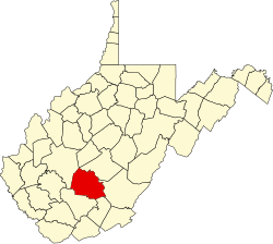
East Kingston is an unincorporated community in Fayette County, West Virginia, United States.
In law, an unincorporated area is a region of land that is not governed by a local municipal corporation; similarly an unincorporated community is a settlement that is not governed by its own local municipal corporation, but rather is administered as part of larger administrative divisions, such as a township, parish, borough, county, city, canton, state, province or country. Occasionally, municipalities dissolve or disincorporate, which may happen if they become fiscally insolvent, and services become the responsibility of a higher administration. Widespread unincorporated communities and areas are a distinguishing feature of the United States and Canada. In most other countries of the world, there are either no unincorporated areas at all, or these are very rare; typically remote, outlying, sparsely populated or uninhabited areas.
Fayette County is a county in the U.S. state of West Virginia. As of the 2010 census, the population was 46,039. Its county seat is Fayetteville. It is part of the Beckley, WV Metropolitan Statistical Area in Southern West Virginia.
West Virginia is a state located in the Appalachian region in the Southern United States and is also considered to be a part of the Middle Atlantic States. It is bordered by Pennsylvania to the north, Maryland to the east and northeast, Virginia to the southeast, Kentucky to the southwest, and Ohio to the northwest. West Virginia is the 41st largest state by area, and is ranked 38th in population. The capital and largest city is Charleston.
Kingston is the capital and largest city of Jamaica, located on the southeastern coast of the island. It faces a natural harbour protected by the Palisadoes, a long sand spit which connects the town of Port Royal and the Norman Manley International Airport to the rest of the island. In the Americas, Kingston is the largest predominantly English-speaking city south of the United States.
Roane County is a county of the U.S. state of Tennessee. As of the 2010 census, the population was 54,181. Its county seat is Kingston.
Hull may refer to:
Preston is a place name, surname and given name that may refer to:
King's Highway 33, commonly referred to as Highway 33 or Loyalist Parkway, is a provincially maintained highway in the Canadian province of Ontario. The route begins at Highway 62 in Bloomfield and travels east to the Collins Bay Road junction at Collins Bay in the city of Kingston, a distance of 60.9 kilometres (37.8 mi). The highway continues farther east into Kingston as Bath Road, ending at the former Highway 2, now Princess Street. Highway 33 is divided into two sections by the Bay of Quinte. The Glenora Ferry service crosses between the two sections just east of Picton, transporting vehicles and pedestrians for free throughout the year.
West Hill is a neighbourhood in Toronto, Ontario, Canada. It is located in the eastern end of the city, in the suburb of Scarborough. It is roughly bounded by Scarborough Golf Club Road and a branch of Highland Creek on the west, the CNR railway tracks and Lake Ontario on the south, and Highland Creek on the north-east. The name comes from its elevated position on the west side of Highland Creek, a deep glacial ravine.
Kingston Road is the southernmost major road along the eastern portion of Toronto, specifically in the district of Scarborough. Until 1998, it formed a portion of Highway 2. The name of the street is derived from Kingston, Ontario as the road was the primary route used to travel from Toronto to the settlements east of it situated along the shores of Lake Ontario; in the west end of Kingston, this highway was referred to as the York Road until at least 1908.
Kingston railway station is in Kingston upon Thames in south-west London. It is 12 miles 9 chains (19.5 km) down the line from London Waterloo. The station and all trains serving it are operated by South Western Railway. It is in Travelcard Zone 6.
East Preston is a village and civil parish in the Arun District of West Sussex, England. It lies roughly halfway between Littlehampton and Worthing. It is primarily residential and a large proportion of retired people, as well as tradespeople and home carers.
Kingston or Kingston by Ferring, is a small civil parish in the Arun District of West Sussex, England. It is a combination of a farmed rural interior and the three neighbourhoods of East Kingston, West Kingston and Kingston Gorse. The parish lies on the coast, between Ferring and East Preston parishes.
Portmore is a large coastal town in southern Jamaica in Saint Catherine, and a dormitory town for the neighbouring city of Kingston and Spanish Town.
Mavis Bank is a rural coffee farming community about 10 miles north east of Kingston, Jamaica in east rural St. Andrew in the Blue Mountains, close to the border of St. Thomas.
This is a list of the National Register of Historic Places listings in Knox County, Tennessee.
The steamboat Defiance operated in the early 1900s as part of the Puget Sound Mosquito Fleet. In later years this vessel was called Kingston.
Kingston is an unincorporated community and coal town in Fayette County, West Virginia, United States. Kingston is 8.5 miles (13.7 km) west of Oak Hill.
The London & South East Men's League is a division within rugby league's tier 4 and was previously a division of the Rugby League Conference. At the division is competed for by teams in the South East of England including London.
Sudbrook and its tributary, the Latchmere stream, are streams that drain the areas of north Kingston upon Thames, Ham and Petersham following the course of a meander scar in a terrace of the River Thames.
Kingston is an district of south-west Glasgow, Scotland, from which the Kingston Bridge takes its name. Together with Ibrox, it forms one of the 56 neighbourhoods of Glasgow defined by Glasgow City Council for operational purposes. The area was assigned to Ward 54 until 2007 when it was reclassified as part of the Govan ward.
This article about a location in Fayette County, West Virginia is a stub. You can help Wikipedia by expanding it. |