Meteorological history | |
---|---|
Formed | February 13, 2021 |
Exited land | February 17, 2021 |
Dissipated | February 24, 2021 |
Category 3 "Major"winter storm | |
Regional Snowfall Index:8.05 (NOAA) | |
Highest winds | 75 mph (120 km/h) |
Lowest pressure | 960 mbar (hPa);28.35 inHg |
Lowest temperature | −30 °F (−34.44 °C) |
Maximum snowfall or ice accretion | 26 in (66 cm) |
Tornado outbreak | |
Tornadoes | 6 |
Maximum rating | EF3 tornado |
Highest winds | 160 mph (260 km/h) |
Overall effects | |
Fatalities | ≥290 (426–978 estimated in Texas) |
Damage | ≥$25.5 billion (2021 USD) |
Areas affected | United States,Canada,Northern Mexico,British Isles,Iceland,Southern Greenland |
Power outages | >9,924,000 |
[1] [2] [3] [4] [5] [6] [7] [8] [9] [10] [11] [12] [13] | |
Part of the 2020–21 North American winter and tornado outbreaks of 2021 |
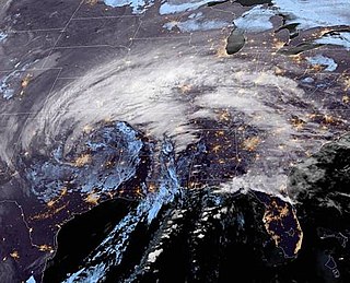
A major winter and ice storm had widespread impacts across the United States,Northern Mexico,and parts of Canada from February 13 to 17,2021. The storm,unofficially referred to as Winter Storm Uri by the Weather Channel, [14] [15] started out in the Pacific Northwest and quickly moved into the Southern United States,before moving on to the Midwestern and Northeastern United States a couple of days later.
The storm resulted in the National Weather Service issuing various winter weather alerts impacting over 170 million Americans. Over 9.9 million people in the U.S. and Mexico experienced blackouts,many due to a major power crisis in Texas, [12] [13] [16] which became the largest in the U.S. since the Northeast blackout of 2003. [17] The storm contributed to a severe cold wave that affected most of North America. The storm also brought severe destructive weather to Southeastern United States,including several tornadoes. On February 16,there were at least 20 direct fatalities and 13 indirect fatalities attributed to the storm; [18] [19] [6] [20] [14] by January 2,2022,the death toll had risen to at least 290,including 276 people in the United States and 14 people in Mexico. [8] [4] [5] [6] [9] [7]
The National Oceanic and Atmospheric Administration officially documented US$24 billion in damage in the United States from the winter storm. [1] Aon PLC,a finance company,estimated the system to have cost over $196.5 billion in damages,including at least $195 billion in the United States and over $1.5 billion in Mexico. This would make it the costliest winter storm on record and the costliest natural disaster recorded in the United States at the time. [21] [3] It was also the deadliest winter storm in North America since the 1993 Storm of the Century,which killed 318 people. [22]
On February 13,a frontal storm developed off the coast of the Pacific Northwest and moved ashore,before moving southeastward,with the storm becoming disorganized in the process. [23] [24] During this time,the storm reached a minimum pressure of 992 millibars (29.3 inHg) over the Rocky Mountains. [24] On the same day,The Weather Channel gave the storm the unofficial name Winter Storm Uri; [14] the Federal Communications Commission adopted the name in their reports from February 17. [15] From February 12 to 13,a trough dipped southward from Northern California into northern Mexico,which channeled moisture from Texas towards the storm,as the system moved southeastward. [25] Over the next couple of days,the storm began to develop as it entered the Southern United States and moved into Texas. [26] From February 13 to 14,a second,much larger trough developed over Central United States,aided by a southward shift from the polar vortex,while the winter storm moved into Texas. The trough became fully developed by February 15,channeling significant amounts of moisture into the winter storm and also contributing to a historic cold wave that affected most of the Central and Eastern United States. [25] Winds in the jet stream reached 170 mph (275 km/h) around the trough. [25] On February 15,the system developed a new surface low off the coast of the Florida Panhandle,as the storm turned northeastward and expanded in size. [27]
On February 16,the storm developed another low-pressure center to the north as the system grew more organized,while moving towards the northeast. [28] [25] Later that day,the storm broke in half,with the newer storm moving northward into Quebec,while the original system moved off the East Coast of the U.S. [29] By the time the winter storm exited the U.S. late on February 16,the combined snowfall from the multiple winter storms within the past month had left nearly 75% of the contiguous United States covered by snow,which was the largest amount of snow cover seen in the United States since early 2003. [3] [30] [25] On February 17,the storm's secondary low dissipated as the system approached landfall on Newfoundland,intensifying in the process. [31] At 12:00 UTC that day,the storm's central pressure reached 985 millibars (29.1 inHg),as the center of the storm moved over Newfoundland. [32] On the same day,the storm was given the name Belrem by the Free University of Berlin. [33] The storm continued to strengthen as it moved across the North Atlantic,with the storm's central pressure dropping to 960 millibars (28 inHg) by February 19. [34] [35] On February 20,the storm developed a second-low pressure area and gradually began to weaken,as it moved northwestward towards Iceland. [36] [37] Afterward,the storm turned westward and moved across southern Greenland on February 22,weakening even further as it did so. [38] The storm then stalled south of Greenland,while continuing to weaken,before dissipating on February 24. [39] [40]
Winter Storm Warning | |||||
Winter Storm Watch | |||||
Winter Weather Advisory | |||||
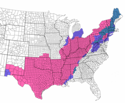
On February 14,the expected impacts from the storm resulted in over 170 million Americans being placed under various winter weather alerts across the United States,which saw the largest portion of the country covered by winter weather alerts in 15 years. [16] [25] Over 120 million of those people were placed under winter storm warnings or ice storm warnings by the National Weather Service. [41] The winter storm caused power grids to fail across the U.S.,causing blackouts for over 5.2 million homes and businesses,the vast majority of which were in the state of Texas,which became one of the largest blackout events in modern U.S. history, [12] [13] [42] the largest one since the Northeast blackout of 2003. [17] The storm was initially reported to have caused 70 deaths across the United States, [43] [44] [9] later updated to at least 276 people dead,246 of them in Texas. [4] [8] A BuzzFeed study in May 2021 estimated that the winter storm may have killed a total of 702 people in Texas,which would add hundreds of deaths to the official death toll if verified. [45] The system was estimated by NOAA to have cost $21 billion in damage in the United States,making it the costliest winter storm in U.S. history at the time. [46] Austin County and Travis County officials estimated that the winter storm caused at least $195 billion in damage in Texas,making the winter storm the single-costliest natural disaster in the history of Texas and the United States as a whole. [21] Some insurance firms had estimated a damage total of between 195 and 295 billion dollars. [47] [48]
The winter storm was the second of the two snowstorms that swept through the region within a one-week period. 11.1 inches (28 cm) of snow in Seattle,Washington,compounded the previous storm. [49] This was the largest two-day snowfall recorded in Seattle since 1972. [50]
The Portland metro area was hit very hard by the storm,which brought a mix of snow and ice to the region. [49] 9.4 inches (24 cm) of snow fell at Portland International Airport on February 12–13,the most snow to fall over this city in a two-day period since 1968. [50] Over 270,000 people were left without power in the region, [51] with 401 miles (645 km) of power lines needing to be restored. [52] The storm led to the largest power outage in state history. [53] Governor Kate Brown declared a state of emergency. [54] [12] Four people were killed in Oregon by carbon monoxide poisoning. [5]
9.9 inches (25 cm) of snow also fell in Boise,Idaho,during this same time period,making this the largest recorded two-day snowfall event for that city since 1996. [50] In Salt Lake City,the 11.7 inches (30 cm) made this storm their snowiest February day on record. [55]
The storm brought heavy snow and bitterly cold temperatures to Colorado and New Mexico. Snow amounts in Colorado ranged from a few inches in the north to over 2 feet (0.61 m) in the San Juan Mountains in northern New Mexico and southern Colorado. [56] In New Mexico,the storm system brought a combination of heavy snow,strong winds,and bitterly cold temperatures. On February 14,a Blizzard Warning was issued for the Albuquerque metro area due to strong winds exceeding 50 miles per hour (80 km/h),cold temperatures,and blowing snow. [57] Meanwhile,Winter Storm Warnings were issued for much of the rest of New Mexico. Up to 2 feet (61 cm) of snow fell in the mountains of northern and central New Mexico. Snow amounts in the Albuquerque metro area ranged from 2 to 6 inches (5.1 to 15.2 cm). Interstate Highway 40 through the Albuquerque metro area was closed for several hours due to numerous motor vehicle crashes caused by the icy conditions. [58] Southern New Mexico received up to 2 inches (5.1 cm) of snow accumulation,with locally higher amounts in the mountains. [59]
With the threat of icing,the Texas Department of Transportation (TxDOT) pre-treated roadways,using a brine-salt mix,across six Southeast Texas counties. [60] For the first time on record,the National Weather Service (through its 13 regional offices serving Texas and adjoining portions of Oklahoma,New Mexico,Arkansas and Louisiana) issued Winter Storm Warnings for all 254 counties in the state. [14] In addition,Houston saw their first ever wind chill warning,as wind chills dipped to 0 °F (−18 °C). [61] Wind chills predicted to be at or below −18 °F (−28 °C) promoted the first ever wind chill warning for Dallas as well. [62]
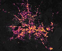
On February 14–15,the storm dropped prolific amounts of snow across Texas and Oklahoma. As a result of the winter storm and a concurrent cold wave,power grids—unable to sustain the higher-than-normal energy and heating demand from residential and business customers—failed across the Texas Interconnection;at the peak of the outages,at least 4.5 million Texas residents were left without electricity. [13] [12] Two of the electricity reliability commissions servicing the Southern U.S.,the Southwest Power Pool (SPP) and the Electric Reliability Council of Texas (ERCOT),ordered rolling blackouts for 14 states amid the frigid temperatures,in an attempt to manage the strain on the power grid and prevent widespread,long-duration blackouts. The controlled outages were initiated after the Southwest Power Pool declared Level 3 Emergency Energy Alerts on both February 15 and 16;the SPP and ERCOT faced criticism by government officials and residents in the region for the limited advanced notice of the outages,and for not outlining the specific areas serviced by SPP partner utilities that would be affected. [63] [64] [65]
At one point during the rolling outages,over 4.2 million people across the south-central states were left without power,with over 3.5 million of them in Texas alone. [66] The rolling blackouts led to calls by Governor Greg Abbott for the Texas Legislature to conduct investigations into preparations and decisions undertaken by ERCOT in advance of the storm. [67] Some of the blackouts were initiated as several cities throughout the Central and Southern Plains experienced record overnight low temperatures:on February 16 alone,daily record lows were broken in Oklahoma City (−14 °F [−26 °C],the city's coldest temperature since 1899 and its second-coldest on record),Dallas (−2 °F [−19 °C],the city's coldest temperature since 1930 and its second-coldest on record),Houston (13 °F [−11 °C],the city's coldest temperature since 1989),San Antonio (5 °F [−15 °C],the city's coldest temperature since 1989) and Little Rock (−1 °F [−18 °C],the city's coldest temperature since 1989),with all-time low temperatures being set in Fayetteville,Arkansas (−20 °F [−29 °C]) and Hastings,Nebraska (−30 °F [−34 °C]). [68]
Rolling blackouts, longer-duration power outages and ice accretion caused by the precipitation and unusually cold temperatures (for the region's climate) caused widespread disruptions to water distribution systems across the Southern Plains. There were water line breaks in many areas, and power disruptions affected water treatment plants in parts of the region that forced several cities—including Houston, San Antonio, Fort Worth, Abilene, Austin, Killeen and Arlington, Texas; and Shreveport, Louisiana—to enact residential boil-water orders (i.e., to boil drinking water to kill pathogens); [70] [71] [72] [73] [74] By February 18, more than 13 million people in Texas lived in areas where boiling water was advised, [75] or using bottled water if heating was not possible. [76] This led to shortages of bottled water in Houston grocery stores. [77] Pipe bursts caused significant damage to numerous residences in the Dallas area and other areas of North Texas.[ citation needed ]
After consulting Dallas Mayor Eric Johnson, two NHL games between the Nashville Predators and the Dallas Stars that were scheduled for the evenings of February 15 and 16 at American Airlines Center were postponed. [78] [79] In contrast, the Oklahoma City Thunder opted to hold their February 16 home game against the Portland Trail Blazers as scheduled, even as most other buildings in Downtown Oklahoma City decided to turn off lighting and electrical equipment overnight to reduce strain on the city's power grid; the NBA team stated that Chesapeake Energy Arena would take steps to conserve power while the game was being played, including turning off concourse lighting, video panels, exterior signage and most outdoor lighting. [80] [81] The Memphis Grizzlies also played against the Oklahoma City Thunder without fans due to the storm. [82]
Due to the deregulated electricity market and the spike in demand, wholesale electricity prices increased, in some places by 10,000 percent, from February 10, [83] leading to extremely high bills [84] of up to $450 for one day's use. [85] Power outages even affected the Big Bend National Park. [86] On February 17, U.S. Senator Ted Cruz (R-TX) stirred controversy when he was filmed boarding an airplane to Cancún, Mexico with his family. He returned to Houston the following day, and admitted he had scheduled the vacation to avoid freezing conditions inside their home. [87]
In Oklahoma, winter storm warnings were issued for all 77 counties in the state ahead of the storm by National Weather Service offices in Norman, Tulsa, Amarillo and Shreveport. Governor Kevin Stitt also issued a statewide winter weather State of Emergency on February 12, as the state was already dealing with effects from minor winter weather events and prolonged sub-freezing temperatures from previous days. [88] Widespread areas of 3–8 inches (7.6–20.3 cm) snowfall were recorded throughout the state, with locally higher amounts. Roosevelt saw 12 inches (30 cm) of snow, the highest total measured in the state during the event. [89]
The heavy, blowing snow caused massive travel issues across the state on February 14. By 5:20 p.m. CST that day, the Oklahoma Highway Patrol had responded to 56 non-injury collisions, 24 injury collisions, and 116 motorist assists. [90] A fiery crash involving multiple vehicles, including two semi-trucks, shut down the Turner Turnpike near Hiwassee Road in northeastern Oklahoma County, with westbound traffic being diverted to the Kickapoo Turnpike and eastbound traffic being diverted to I-35. [91] Another vehicle collision on I-35 near Braman caused one fatality. [6] The record cold temperatures during the event also caused a dam at Lake Overholser to completely freeze over. [92]
By February 16, the storm had killed at least 17 people across the South. [93] [18] By February 18, the death toll rose to at least 47. [94] [95] [96] At least 10 people in Texas died in weather-related incidents since February 14, including a mother and a child due to carbon monoxide poisoning. [5] By January 2, 2022, the Texas State Government revised the official death toll in Texas to 246. [8] Nine other people in the South, outside Texas, died as a result of the system or through indirect storm-related incidents. [5] [6] According to a BuzzFeed study in May 2021, based on the excess mortalities in Texas in February 2021, the actual death toll of the winter storm may range from 426 to 978 in Texas, with a mean estimate of 702, which would add hundreds of deaths to the official death toll, if verified. [45] The official death toll was modified in December 2021 with the Texas Department of State Health Services announcing a death toll of 246. [97]
The storm was also partially responsible for a nationwide chicken shortage, due to the freezing temperatures, widespread power and water outages that lasted days. [98] [99] [100] [101] [102]
Chicago along with other cities in northern Illinois received up to 14–17 in (36–43 cm) of snow along with winds up to 20 mph (32 km/h). Due to the snowstorm, several Chicago Transit Authority trains suspended operations on February 16. [103] Chicago experienced its snowiest 3-week period since 1979. [104] Indianapolis, Indiana, received about 7 in (18 cm) of snow as well as Detroit, Michigan, also had 7 in (18 cm) of snow. Toledo, Ohio, received 14.5 in (37 cm) of snow, the third-highest two-day snowfall record, and the highest since 1912. Other Northern Ohio cities received up to 10–12 in (25–30 cm) of snow while cities in the central part received up to 3 in (7.6 cm) of snow like in Columbus, Ohio. [105] After the storm, Milwaukee set a record for deepest snow depth ever. [106]
EFU | EF0 | EF1 | EF2 | EF3 | EF4 | EF5 |
---|---|---|---|---|---|---|
0 | 4 | 0 | 1 | 1 | 0 | 0 |
A severe weather outbreak struck the Southeastern United States on February 15, with large hail, damaging winds, and six tornadoes affecting five states. [107] An EF2 tornado destroyed two homes and damaged trees near Damascus, Georgia, injuring five people. A more destructive high-end EF3 tornado struck the Ocean Ridge Plantation neighborhood near Sunset Beach, North Carolina, causing major damage to many homes, some of which were leveled or swept away, before moving into rural areas and damaging or snapping hundreds of trees. This tornado killed three and injured 10. [108] [109]
EF# | Location | County / Parish | State | Start Coord. | Time (UTC) | Path length | Max width | Summary |
---|---|---|---|---|---|---|---|---|
EF0 | NW of Panama City Beach | Bay | FL | 30°13′16″N85°53′23″W / 30.2211°N 85.8898°W | 20:02–20:04 | 1.31 mi (2.11 km) | 50 yd (46 m) | A high-end EF0 tornado caused minor damage to structures, poles, benches, and fencing occurred near the beach and at Frank Brown Park in Gulf Resort Beach. [110] |
EF0 | W of Compass Lake | Washington | FL | 30°35′58″N85°27′21″W / 30.5994°N 85.4557°W | 20:39–20:41 | 0.71 mi (1.14 km) | 100 yd (91 m) | A brief high-end EF0 tornado pulled out an outbuilding anchored by wooden poles in shallow concrete, lofting it 20 yards (18 m). Several pine trees were snapped along a driveway. Further north, a double wide manufactured home had minor roof damage. Several other trees were uprooted along the path. [111] |
EF0 | WNW of Lake City | Columbia | FL | 30°12′25″N82°44′17″W / 30.207°N 82.738°W | 21:17–21:21 | 0.25 mi (0.40 km) | 60 yd (55 m) | There was sporadic damage to trees, fences roofs and other damage to residential buildings. A fence panel was blown about 750 feet (230 m). [112] |
EF0 | ENE of Desser | Seminole | GA | 30°53′N84°49′W / 30.89°N 84.82°W | 21:29–21:30 | 0.5 mi (0.80 km) | 50 yd (46 m) | Trees were blown down in a rural area. No structural damage was found, but a brief tornado debris signature appeared on radar. [113] |
EF2 | S of Damascus to E of Iveys Mill | Early, Baker | GA | 31°16′52″N84°43′16″W / 31.281°N 84.7211°W | 21:38–21:48 | 11.58 mi (18.64 km) | 600 yd (550 m) | This strong tornado first touched down just west of SR 45, where it snapped several trees and damaged the roofs of some homes. Further northeast, the tornado reached its peak intensity as it completely destroyed two small and unanchored homes just south of Damascus, one made of concrete blocks, and the other made of wood with a concrete block foundation. Only scattered debris and the foundations remained of these structures, and a nearby detached garage was also completely destroyed. A truck was tossed from the garage, and cars were heavily damaged. Five injuries occurred at these homes. A third home sustained damage to its exterior and was shifted off its foundation. Trees were also snapped or uprooted, with two cases of metal poles being lodged into trees. A propane tank was dislodged and moved, and power lines went down. Farther northeast, the tornado weakened as it snapped and uprooted more trees. Some minor roofing damage occurred before the tornado lifted. [114] [115] |
EF3 | N of Sunset Beach to SW of Delco | Brunswick | NC | 33°54′42″N78°30′35″W / 33.9118°N 78.5096°W | 04:34–05:02 | 21.9 mi (35.2 km) | 275 yd (251 m) | 3 deaths – This destructive tornado touched down at the north edge of Sunset Beach, just north of the border with South Carolina, damaging numerous pine trees and limbs at EF0 intensity as it crossed NC 179, before rapidly intensifying to EF2 strength as it neared NC 904. [116] A tornado warning was not issued until after the tornado touched down and began causing damage. [117] As the tornado crossed the road, a large metal building was destroyed and a number of RVs were overturned. Still rapidly strengthening, the tornado entered Grissettown and struck the Ocean Ridge Plantation subdivision at its peak intensity of high-end EF3. A community garden center and two homes were leveled at this location, one of which was swept completely away. This home was well-constructed, but built on a block foundation, and vehicles parked at the site were moved only short distances. Dozens of other nearby homes were damaged, some of which sustained loss of roofs and exterior walls. Many large trees were snapped and denuded in the subdivision, and a car was overturned. All three fatalities occurred in the Ocean Ridge Plantation subdivision. The tornado then abruptly weakened, but reached its maximum width as it crossed US 17 between Grissettown and Cool Run as it exited Ocean Ridge Plantation at EF1 strength, rolling a double-wide mobile home on the north side of the highway. As the tornado continued northeast, it reintensifed to EF2 strength, causing major damage to several homes and snapping hundreds of trees. It then inflicted a continuous path of tree damage through forest and swamp land, crossing NC 130 and NC 211. [116] The tornado finally lifted east of NC 211. [118] It was the deadliest single tornado in Southeastern North Carolina since an F3 touched down on November 16, 2006, [9] and the first deadly tornado in Brunswick County. [119] The tornado caused three deaths, in the sixth consecutive year with tornado fatalities in February. There were also ten injuries. [120] |
The winter storm strained the power grids in northern Mexico, leading to cascading blackouts for 4.7 million homes and businesses in Mexico. [12] Temperatures as low as −18 °C (0 °F) were recorded, as shortages of natural gas led to blackouts in Nuevo León, Coahuila, Tamaulipas, and Chihuahua along the border with Texas. [121] At least 14 people died in Ciudad Juárez, Chihuahua; Río Bravo and Matamoros, Tamaulipas; and Monterrey, Nuevo León; due to the winter storm. [7] [20] President Andrés Manuel López Obrador (AMLO) said on February 17 that Mexico would increase the use of oil and coal to produce electricity, as well as purchase three shiploads of natural gas to deal with power shortages. He also warned that periodic local outages would continue through February 21. [122] Local authorities said that no hospitals had been left without electricity at any time. [123] The storm was estimated to have caused over US$1.5 billion in damages in Mexico. [3]
In Ontario, snowfall warnings were issued in advance of the winter storm. School bus service was cancelled across the Greater Toronto Area, and schools were completely closed in Halton and Durham. [124] 20 cm (7.9 in) of snow fell in Windsor, 12 cm (4.7 in) at Toronto Pearson International Airport and 18 cm (7.1 in) fell in Ottawa. The highest totals in the region were the over 30 cm (12 in) in and around the Hamilton and Niagara Region. [125]
The storm was shortly followed by another major winter storm a few days later, which caused at least an additional 29 fatalities and US$2 billion in damage, worsening the 2021 Texas power crisis and hampering recovery efforts in the state. [126] [127] [128]
The January 2007 North American ice storm was a severe ice storm that affected a large swath of North America from the Rio Grande Valley to New England and southeastern Canada, starting on January 11 and lasting until January 16. It was followed by a second wave in the Southern United States from Texas to the Carolinas from January 16 through January 18, and a third one that hit the southern Plains and mid-Atlantic states as well as Newfoundland and Labrador from January 19 to January 24. It resulted in at least 74 deaths across 12 U.S. states and three Canadian provinces, and caused hundreds of thousands of residents across the U.S. and Canada to lose electric power.
The 2011 Groundhog Day blizzard was a powerful and historic winter storm that affected large swaths of the United States and Canada from January 31 to February 2, 2011, especially on Groundhog Day. During the initial stages of the storm, some meteorologists predicted that the system would affect over 100 million people in the United States. The storm brought cold air, heavy snowfall, blowing snow, and mixed precipitation on a path from New Mexico and northern Texas to New England and Eastern Canada. The Chicago area saw 21.2 inches (54 cm) of snow and blizzard conditions, with winds of over 60 mph (100 km/h). With such continuous winds, the blizzard continued to the north and affected Eastern and Atlantic Canada. Blizzard conditions affected many other large cities along the storm's path, including Tulsa, Oklahoma City, Kansas City, St. Louis, Springfield, El Paso, Las Cruces, Des Moines, Milwaukee, Detroit, Chicago, Indianapolis, Dayton, Cleveland, New York City, New York's Capital District, and Boston. Many other areas not normally used to extreme winter conditions, including Albuquerque, Dallas and Houston, experienced significant snowfall or ice accumulation. The central Illinois National Weather Service in Lincoln, Illinois, issued only their fourth blizzard warning in the forecast office's 16-year history. Snowfall amounts of 20 to 28 inches were forecast for much of Northern and Western Illinois.
The March 2014 North American winter storm, also unofficially referred to as Winter Storm Titan, was an extremely powerful winter storm that affected much of the United States and portions of Canada. It was one of the most severe winter storms of the 2013–14 North American winter storm season, storm affecting most of the Western Seaboard, and various parts of the Eastern United States, bringing damaging winds, flash floods, and blizzard and icy conditions.
The 2013–14 North American winter was one of the most significant for the United States, due in part to the breakdown of the polar vortex in November 2013, which allowed very cold air to travel down into the United States, leading to an extended period of very cold temperatures. The pattern continued mostly uninterrupted throughout the winter and numerous significant winter storms affected the Eastern United States, with the most notable one being a powerful winter storm that dumped ice and snow in the Southeastern United States and the Northeastern United States in mid-February. Most of the cold weather abated by the end of March, though a few winter storms did affect the Western United States towards the end of the winter.
The December 2014 North American storm complex was a powerful winter storm that impacted the West Coast of the United States, beginning on the night of December 10, 2014, resulting in snow, wind, and flood watches. Fueled by the Pineapple Express, an atmospheric river originating in the tropical waters of the Pacific Ocean adjacent to the Hawaiian Islands, the storm was the strongest to affect California since January 2010. The system was also the single most intense storm to impact the West Coast, in terms of minimum low pressure, since a powerful winter storm in January 2008. The National Weather Service classified the storm as a significant threat, and issued 15 warnings and advisories, including a Blizzard Warning for the Northern Sierra Nevada.
The 2015–16 North American winter was not as frigid across North America and the United States as compared to the 2013–14 and 2014–15 winters. This was mainly due to a strong El Niño, which caused generally warmer-than-average conditions. However, despite the warmth, significant weather systems still occurred, including a snowstorm and flash flooding in Texas at the end of December and a large tornado outbreak at the end of February. The main event of the winter season, by far and large, was when a crippling and historic blizzard struck the Northeastern United States in late January, dumping up to 3 feet of snow in and around the metropolitan areas. Several other smaller snow events affected the Northeast as well, but for the most part the heaviest snowstorms and ice stayed out further west, such as a severe blizzard in western Texas in late December, and a major late-season snowstorm in Colorado in mid-April.
The December 2015 North American storm complex, also known as Winter Storm Goliath, was a major storm complex that produced a tornado outbreak, a winter storm, a blizzard and an ice storm in areas ranging from the Southwestern United States to New England. Tornadoes impacted areas around Dallas, Texas while several other states, especially Missouri, were affected by heavy rain and snow causing severe floods. As the system moved through the Great Lakes region, heavy rain, ice pellets and heavy snow fell in the entire region. Wintry mix moved through southern Ontario and Quebec had significant snowfall on December 29. Almost 60 people were killed in the storm system and its aftermath, which made it one of the deadliest of such systems of 2015 in the United States.
The 2010–11 North American winter was influenced by an ongoing La Niña, seeing winter storms and very cold temperatures affect a large portion of the Continental United States, even as far south as the Texas Panhandle. Notable events included a major blizzard that struck the Northeastern United States in late December with up to 2 feet (24 in) of snowfall and a significant tornado outbreak on New Year's Eve in the Southern United States. By far the most notable event was a historic blizzard that impacted areas from Oklahoma to Michigan in early February. The blizzard broke numerous snowfall records, and was one of the few winter storms to rank as a Category 5 on the Regional Snowfall Index. In addition, Oklahoma set a statewide low temperature record in February.
The 2016–17 North American winter was quite warm across North America in general, due in part to a weak La Niña that was expected to influence weather conditions across the continent. Several notable events occurred during the season, including a potent winter storm that affected the East Coast of the United States in early January, the second-largest winter tornado outbreak on record later that month, and an unusually warm February. In addition, towards the end of the season, a large cyclonic storm system that caused a large tornado outbreak, flooding, and a potent blizzard occurred in the Heartland of the country. However, the most notable event of the winter was a powerful blizzard that impacted the Northeast and New England in mid-March, towards the end of the season.
The January 2017 North American ice storm was a major ice storm that impacted the Great Plains, Pacific Northwest, and American Midwest. During the storm, multiple U.S. states declared states of emergency, and icy road conditions caused traffic incidents and fatalities. It was Named Winter Storm Jupiter by the weather channel. An outbreak of 11 tornadoes also struck Texas, injuring two.
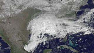
The February 2015 Southeastern United States winter storm was a rare winter storm that dumped up to a foot of snow in the Southeast, an area that rarely receives such heavy snowfall. Forming out of a shortwave trough that developed over Texas near the Gulf of Mexico on February 24, the storm quickly made its way over the southern United States, coalescing into a surface low-pressure area as it did so. With arctic air unusually far south, this helped spawn heavy, wet snowfall across the northern portions of several southern states, including the suburbs of Atlanta, Georgia. States such as Alabama and Georgia declared a state of emergency in the northern portions of the state due to the possibility of up to 6 inches (15 cm) of snow, which was normally never seen.
The 2020–21 North American winter was the most significant winter season to affect North America in several years, and the costliest on record, with a damage total of at least $33.35 billion. The season featured 6 storms ranking on the Regional Snowfall Index scale, with 4 storms ranking as at least a Category 3. Most of the winter's damage and fatalities occurred due to a historic and major cold wave in mid-February. Several other significant events occurred, including a crippling early-season ice storm in the Southern Plains, a powerful nor'easter in mid-December, another major nor'easter in early February, two major and widespread winter storms in mid-February, and a major blizzard in the Rocky Mountains in mid-March. The winter-related events were responsible for at least 358 fatalities, making it the deadliest season since 1992–93. A La Niña pattern influenced much of the winter in North America.
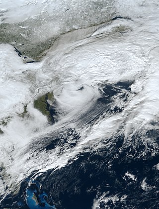
The December 15–17, 2020 nor'easter was a powerful nor'easter that hammered the Northeastern United States and produced widespread swaths of over 1 foot (12 in) of snow in much of the region from December 15–17, 2020, ending a 1,000+ day high-impact snowstorm drought in much of the Mid-Atlantic and coastal New England regions. The system developed out of a weak area of low-pressure that first developed over the Central United States producing some snowfall before moving eastward, and by December 16, a new, dominant area of low pressure began to develop along the Southeast coast. This low steadily deepened as it moved along and impacted the Mid-Atlantic coastline, prompting several winter-related advisories and warnings for much of the Northeast.
The 2020–21 New Year's North American winter storm was a major storm system that brought a wide swath of snow and ice to parts of the High Plains and Central and Northeastern United States during the New Years holiday from December 30–January 2. The system began developing early on December 30, and began spreading wintry precipitation to parts of Texas, coalescing into a low pressure system that formed near the western Gulf of Mexico. The winter storm tracked north and brought heavy snow, ice and strong winds to much of the center of the Midwest and interior parts of the Northeast and New England, causing widespread impacts and travel issues.
The February 15–20, 2021 North American winter storm, also unofficially referred to as Winter Storm Viola, was a significant and widespread snow and ice storm across much of the United States, Northern Mexico, and Southern Canada. The system started out as a winter storm on the West Coast of the United States on February 15, later moving southeast into the Southern Plains and Deep South from February 16–17. It then moved into the Appalachian Mountains and Northeastern United States, before finally moving out to sea on February 20. The storm subsequently became a powerful low pressure system over the North Atlantic, before eventually dissipating on February 26.
In February 2021, the state of Texas suffered a major power crisis, which came about during three severe winter storms sweeping across the United States on February 10–11, 13–17, and 15–20. The storms triggered the worst energy infrastructure failure in Texas state history, leading to shortages of water, food, and heat. More than 4.5 million homes and businesses were left without power, some for several days. At least 246 people were killed directly or indirectly, with some estimates as high as 702 killed as a result of the crisis.
The February 2021 North American cold wave was an extreme weather event that brought record low temperatures to a significant portion of Canada, the United States and parts of northern Mexico during the first half of February 2021. The cold was caused by a southern migration of the polar vortex, likely caused by a sudden stratospheric warming event that occurred the prior month. Temperatures fell as much as 25-50 degrees F below average as far south as the Gulf Coast. Severe winter storms also were associated with the bitter cold, which allowed for heavy snowfall and ice accumulations to places as far south as Houston, Texas, and contributing to one of the snowiest winters ever in some areas in the Deep South.
The 2021–22 North American winter was not as significant and record-breaking as the previous winter season. Despite this, several notable and significant events still occurred, including two separate record-breaking tornado outbreaks in mid-December, a significant winter storm in the South in mid-January, a powerful blizzard that impacted the Northeast coast at the end of January and a wide-ranging, significant winter storm that affected most of the eastern half of the country in early February. Additional significant events included a late-season winter storm in March that affected the Appalachian Mountains, and a major blizzard that affected North and South Dakota in mid-April. Additionally, a very late out-of-season snowstorm struck the Rocky Mountains in late May. During the season, four storms have been ranked on the Regional Snowfall Index (RSI), although none attained the “Major” category. Similar to the previous winter, a developing La Niña was expected to influence weather patterns across the continent.
The January 14–17, 2022, North American winter storm brought widespread impacts and wintry precipitation across large sections of eastern North America and parts of Canada. Forming out of a shortwave trough on January 13, it first produced a swath of snowfall extending from the High Plains to the Midwestern United States. The storm eventually pivoted east and impacted much of the Southern United States from January 15–16 before shifting north into Central Canada, the Mid-Atlantic states, and the Northeastern United States. The system, named Winter Storm Izzy by The Weather Channel, was described as a "Saskatchewan Screamer".
The February 2022 North American winter storm was a widespread, damaging, and severe winter storm which affected a wide swath of much of the United States with widespread wintry precipitation; it spread from Texas northeast to Maine. Nineteen states in the U.S. were impacted by the system; more than 90 million people were in the storm's path. The winter storm was named Winter Storm Landon by The Weather Channel and was also referred to by other media outlets as the Groundhog Snowstorm, primarily due to the storm impacting on Groundhog Day.
{{cite news}}
: CS1 maint: multiple names: authors list (link)