
Apache Junction is a city in Maricopa and Pinal counties in the state of Arizona. According to the 2019 U.S. Census estimates, the population of the city was 42,571, most of whom lived in Pinal County. It is named for the junction of the Apache Trail and Old West Highway. The area where Apache Junction is located used to be known as Youngberg, AZ. Superstition Mountain, the westernmost peak of the Superstition Mountains, is nearby.
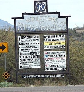
New River is an unincorporated community and a census-designated place (CDP) in Maricopa County, Arizona. The population was 14,952 at the 2010 census.

Superstition Mountain is a prominent mountain and regional landmark located in the Phoenix metropolitan area of Arizona, immediately east of Apache Junction and north of Gold Canyon. It anchors the west end of the federally designated Superstition Wilderness Area and is a popular outdoor recreation destination, home to numerous trails for hiking and horseback riding. The legend of the Lost Dutchman's Gold Mine centers around the mountain.

Mount Graham is a mountain in Graham County, Arizona, United States, approximately 70 miles (110 km) northeast of Tucson. The mountain reaches 10,724 feet (3,269 m) in height. It is the highest elevation in Graham County, Coronado National Forest and the Pinaleño Mountains. It is also the southernmost peak and land area in the continental United States above 10,000 feet (3,048 m). As the name "Mount Graham" is often used by locals to refer to the entire mountain range, the peak itself is frequently referred to as "High Peak". It is twentieth of the 57 ultra prominent peaks of the lower 48 states, and the first of the five in Arizona.

Black Mesa is an upland mountainous mesa of Arizona, north-trending in Navajo County, west and southeast-trending in Apache County. In Navajo it is called Dziłíjiin and during Mexican rule of Arizona it was called Mesa de las Vacas. It derives its dark appearance from the numerous seams of coal that run through it.
Sentinel Peak is a 2,897 ft peak in the Tucson Mountains southwest of downtown Tucson, Arizona. The valley's first inhabitants grew crops at the mountain's base, along the Santa Cruz River. The name "Tucson" is derived from the O'odham Cuk Ṣon[tʃʊk ʂɔːn], meaning "[at the] base of the black [hill]". In the 1910s, University of Arizona students used local basalt rock to construct a 160-ft-tall block "A" on the mountain's east face, near its summit, giving the peak its other name, "A" Mountain. The peak is part of a 272-acre park, the largest natural resource park in the City of Tucson.
The Pinaleño Mountains, are a remote mountain range in southeastern Arizona, near Safford, Arizona. The mountains have over 7,000 feet (2,100 m) of vertical relief, more than any other range in the state. The mountains are surrounded by the Sonoran-Chihuahuan Desert. Subalpine forests cover the higher elevations. According to The Nature Conservancy, they traverse five ecological communities and contain "the highest diversity of habitats of any mountain range in North America." The highest point is Mount Graham at 10,720 feet (3,267 m). Locals often refer to the whole mountain range as "Mount Graham", in which case the peak is referred to as "High Peak". The mountains cover 300 square miles (780 km2) and are part of the Coronado National Forest, Safford ranger district.

Theodore Roosevelt Lake is a large reservoir formed by Theodore Roosevelt Dam on the Salt River in Arizona as part of the Salt River Project (SRP). Located roughly 80 miles (130 km) northeast of Phoenix in the Salt River Valley, Theodore Roosevelt is the largest lake or reservoir located entirely within the state of Arizona. The reservoir and the masonry dam that created it, Roosevelt Dam, were both named after U.S. President Theodore Roosevelt who dedicated the dam himself in March 1911. Roosevelt Lake is a popular recreation destination within the Tonto National Forest; the facilities located at this lake are managed by that authority.

Agassiz Peak is the second-highest mountain in the U.S. state of Arizona at 12,360 feet (3,767 m). It is located north of Flagstaff, Arizona in the San Francisco Peaks. It is in the Kachina Peaks Wilderness on the Coconino National Forest. The peak was named in honor of Louis Agassiz, a Swiss-born American biologist and geologist.

Mount Baldy is a mountain in eastern Arizona in the United States. With a summit elevation of 11,409 feet (3,477 m), the peak of Mount Baldy rises above the tree line and is left largely bare of vegetation, lending the mountain its current name. The Mount Baldy Wilderness occupies the eastern slope of the mountain and is managed by the Apache-Sitgreaves National Forest.
Escudilla Mountain is located in Apache County, Arizona, and is part of the White Mountains. The peak is approximately 3.5 miles from the Arizona-New Mexico border. The summit is the highest point in the Escudilla Wilderness which is administered as part of the Apache-Sitgreaves National Forest.

Red Rock is an unincorporated community and census-designated place (CDP) in Apache County, Arizona, United States. Red Rock is located on the Navajo Nation near the New Mexico border, 16 miles (26 km) northeast of Lukachukai. Red Rock has a post office with ZIP code 86544; the post office uses the Red Valley name. As of the 2010 census, the Red Rock CDP had a population of 169.
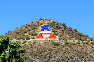
The North Valley Parkway, also named the Gavilan Peak Parkway are two names for a single section of arterial parkway in Phoenix and Anthem, Arizona, generally running parallel to the Interstate 17 (I-17) from Jomax Road to north of New River Road for approximately 15 miles (24.14 km). In the last three years, the parkway has undergone changes from a series of non-contiguous partially unpaved segments of dead end drives into a major alternative route to the often congested I-17 in the North Valley. The parkway is expected to be fully completed by 2020. The parkway follows the alignments of 23rd, 27th, and 35th Avenues in the Maricopa County street grid.

Poston Butte, is a hill located along Hunt Highway in Florence, Pinal County, Arizona, United States, near the eastern end of the Santan Mountains. Geologically, it is characterized by basalts overlying altered granite.

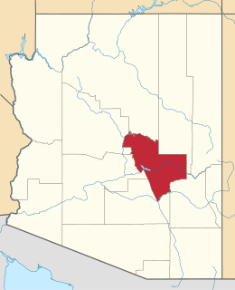
The Pinal Mountains are a mountain range located in Gila County, Arizona. They have a maximum elevation of 7,848 ft (2,392 m) at Pinal Peak and a prominence of over 4,000 ft (1,200 m). The closest city is the Globe, Arizona/Miami, Arizona area, which is just a few miles north of the mountain range. The mountains are located within the Tonto National Forest, and their recreational facilities are maintained by the USDA's United States Forest Service. The San Carlos Indian Reservation is very close to the mountain range, with its boundaries being just a few miles east/northeast of the range. The mountains are covered with Ponderosa Pine and white fir and experience cooler weather than the Globe/Miami area, so that they are a popular recreation area in the summer. The maintained facilities include a maintained dirt road that goes all the way to the summit of Pinal Peak, a campsite and recreational area, many hiking trails, as well as some radio towers near both Pinal and Signal peaks. The mountain range covers an area of 45,760 acres.
The Mescal Mountains are a series of connected mountain ridges in southern Gila County, Arizona. Their highest point is El Capitan Mountain, which has an elevation of 6,568 ft and a prominence of 1,828 ft. The highest point has a topographic isolation of 5.98 miles, with the nearest point of equal or greater elevation being to the north west in the Pinal Mountains. The mountain ridges are visible in the east from Arizona State Route 77 between Globe and Winkelman.The range is approximately 10 miles west of San Carlos Lake, which lies in the San Carlos Apache Indian Reservation; the ridges themselves also mostly fall within the boundary of the reservation, with the exception of the western section and the high point. As such, hiking the ridge may require special permission from San Carlos Apache Indian Reservation, although no trails exist on the mountains themselves or leading to them. The ridge's relative proximity to the more visually dominant Pinal Mountains, make it an often-overlooked feature. The range is one of many to occur in the Arizona transition zone.
The Sevenmile Mountains are a mountain range in central Gila County in the U.S. state of Arizona. The range has a maximum elevation of 6,629 ft (2,021 m) and a prominence of 989 ft (301 m). The highest peak is labelled Seven on the USGS topo sheet and has a topographic isolation of 13.35 miles. The majority of the southern end of the range is located on the San Carlos Apache Indian Reservation. The high point and the northwestern tip of the range is in the Tonto National Forest and is open to free range hiking. The mountains' high point is located just 3 miles east from a section of the U.S. Route 60 in Arizona in between Globe, Arizona and Show Low, Arizona. The southern end of the range that is inside the San Carlos Apache Indian Reservation should only be hiked with permission from the Reservation. The range is one of many that occur in the Arizona transition zone.
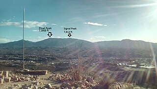
Pinal Peak, located in southern Gila County, Arizona, is the highest point in the Pinal Mountains, with an elevation of 7,848 feet (2,392 m). It is the highest point of land located in between the Salt and Gila rivers in Arizona before they merge, making it visible from miles away on a clear day. The peak ranks as the 11th most prominent in Arizona and has a topographic isolation of 35 miles (56 km), with the nearest point of land of equal or greater elevation being to the southeast in the Santa Teresa Mountains. Pinal Peak is slightly east of the approximate center of the Pinal Mountains. Despite being the most prominent peak in Gila County, it is not the highest point in the county. That title goes to Myrtle Point with an elevation between 7,963 and 8,003 feet (2,427–2,439 m), which lies atop the edge of the Mogollon Rim which forms the county line with Coconino County. The nearest population is in the Globe/Miami, Arizona area, just a few miles north of the range and peak.

The Blackjack Mountains are a mountain range located in Gila County, Arizona. They have a maximum elevation of 6,942 ft (2,116 m) at Apache Peaks and a prominence of 2,580 ft (790 m). The peak has a topographic isolation of 17.88 miles, with the nearest higher peak lying to the south in the Pinal Mountains. The Blackjack mountains are located within the Tonto National Forest and are north of Globe, Arizona. The high point of the range, Apache Peaks, is ranked 36th in prominence for Arizona's most prominent peaks.

