History of Mangalore

Last updated

The History of Mangalore dates back to the 3rd century BC and has been ruled by a number of rulers. In the era of modern India, the area was controlled by the Portuguese in Goa and Bombay, who lost it to Shivappa Nayaka, who in turn lost it to Hyder Ali.

Contents

Mangalore was a part of the Pandyan dynasty Pandya Kingdom (south India).png
Mangalore was a part of the Pandyan dynasty

Until India's independence Mangalore remained under the rule of British India who had taken over by defeating Tipu Sultan in the Third Anglo-Mysore War. Mangalore which was a part of the Madras Presidency was merged into a unified Mysore State in 1956.

Multilingual city

The Sultan Battery in Mangalore, built in 1784 by Tipu Sultan to defend the city from British warships entering the Gurupura river Sultan Battery 2163.JPG
The Sultan Battery in Mangalore, built in 1784 by Tipu Sultan to defend the city from British warships entering the Gurupura river

Mangalore is the heart of a distinct multilinguistic—cultural region : Tulunadu a homeland of Tulu-speaking People, which was nearly coterminous with the modern district of South Canara. [3] In the third century BC, the town formed part of the Maurya Empire, ruled by the Mauryan emperor, Ashoka of Magadha. [4] :176 From the third to sixth century AD, the Kadamba dynasty, whose capital was based in Banavasi in North Canara, ruled over the entire Canara region as independent rulers. [5] From the middle of the seventh century to the end of the 14th century, the South Canara region was ruled by its own native Alupa rulers. An Old Malayalam inscription (Ramanthali inscriptions), dated to 1075 CE, mentioning king Kunda Alupa, the ruler of Alupa dynasty of Mangalore, can be found at Ezhimala (the former headquarters of Mushika dynasty) near Cannanore, in the North Malabar region of Kerala. [6] The Alupas ruled over the region as feudatories of major regional dynasties like the Chalukyas of Badami, Rashtrakutas of Manyakheta, Chalukyas of Kalyani, and Hoysalas of Dwarasamudra. [7] :17 During the reign of the Alupa king Kavi Alupendra (c. 1110 – c.1160), in the 1130s and 1140s, the city was home to the Arabic-speaking Tunisian Jewish merchant Abraham Ben Yiju. [8]

Ibn Battuta

The Moroccan traveller Ibn Battuta, who had visited the town in 1342, referred to it as Manjarur, and stated that the town was situated on a large estuary, called the "estuary of the wolf," and was the greatest estuary in the country of Malabar. [9] [10] :30 By 1345, the Vijayanagara rulers brought the region under their control. [7] :17 During the Vijayanagara period (1345–1550), South Canara was divided into Mangalore and Barkur rajyas (provinces), and two governors were appointed to look after each of them from Mangalore and Barkur. But many times only one governor ruled over both Mangalore and Barkur rajyas, and when the authority passed into the hands of Keladi rulers (c. 1550–1763), they had a governor at Barkur alone. [7] :19 In 1448, Abdur Razzaq, the Persian ambassador of Sultan Shah Rukh of Samarkand, visited Mangalore, en route to the Vijayanagara court. [10] :31 The Italian traveller, Ludovico di Varthema, who visited India in 1506 says that he witnessed nearly sixty ships laden with rice ready for sail in the port of Mangalore. [7] :20

European influence

European influence in Mangalore can be traced back to 1498, when the Portuguese explorer Vasco da Gama landed at St Mary's Island near Udupi, just after his arrival at Koyilandy, Kozhikode. [11] In the 16th century, the Portuguese came to acquire substantial commercial interests in Canara. Krishnadevaraya (1509–1529), the then ruler of the Vijaynagara empire maintained friendly relations with the Portuguese. The Portuguese trade was gradually gathering momentum and they were striving to destroy the Arab and Moplah trade along the coast. In 1524, when Vasco da Gama heard that the Muslim merchants of Calicut had agents at Mangalore and Basrur, he ordered the rivers to be blockaded. In 1526, the Portuguese under the viceroyship of Lopo Vaz de Sampaio took possession of Mangalore. The coastal trade passed out of Muslim hands into Portuguese hands. [7] :20 In 1550, the Vijayanagara ruler, Sadashiva Raya, entrusted the work of administering the coastal region of Canara to Sadashiv Nayaka of Keladi. By 1554, he was able to establish political authority over South Canara. The disintegration of the Vijaynagara Empire in 1565 gave the rulers of Keladi greater power in dealing with the coastal Canara region. [7] :27 They continued the Vijayanagara administrative system. The two provinces of Mangalore and Barkur continued to exist. The Governor of Mangalore also acted as the Governor of the Keladi army in his province. [7] :30 In 1695, the town was torched by Arabs in retaliation for Portuguese restrictions on Arab trade. [12] The 16th century work Tuhfat Ul Mujahideen written by Zainuddin Makhdoom II appears to be the first historical work written in detail about the contemporary history of Mangalore. It is written in Arabic and contains pieces of information about the resistance put up by the navy of Kunjali Marakkar alongside the Zamorin of Calicut from 1498 to 1583 against Portuguese attempts to colonize Tulu Nadu and Malabar coast. [13] [14] [15]

Mysore Sultans

A pen and ink drawing of Mangalore Fort made in 1783, after it had been taken by the English East India Company Mangalorefort1783.jpg
A pen and ink drawing of Mangalore Fort made in 1783, after it had been taken by the English East India Company

Hyder Ali, the de facto ruler of the Kingdom of Mysore, conquered Mangalore in 1763, [16] consequently bringing the city under his administration until 1767. Mangalore was ruled by the British East India Company from 1767 to 1783, [17] but was subsequently wrested from their control in 1783 by Hyder Ali's son, Tipu Sultan; who renamed it Jalalabad. [18] [19] The Second Anglo–Mysore War ended with the Treaty of Mangalore, signed between Tipu Sultan and the British East India Company on 8 March 1784. [20] After the defeat of Tipu at the Fourth Anglo–Mysore War, the city remained in control of the British, headquartering the Canara district under the Madras Presidency. [21] [22] [23]

Ancient port

According to the Scottish physician Francis Buchanan who visited Mangalore in 1801, Mangalore was a rich and prosperous port with flourishing trading activity. [24] Rice was the grand article of export, and was exported to Muscat, Bombay, Goa and Malabar. Supari or Betel-nut was exported to Bombay, Surat and Kutch. Pepper and Sandalwood were exported to Bombay. Turmeric was exported to Muscat, Kutch, Surat and Bombay, along with Cassia Cinnamon, Sugar, Iron, Saltpeter, Ginger, Coir and Timber. [24]

The Light House Hill tower in Light House Hill, Hampankatta, served as a watchtower for the British Navy. Light House Hill, Mangalore.JPG
The Light House Hill tower in Light House Hill, Hampankatta, served as a watchtower for the British Navy.

British period

The British colonial government did not support industrialisation in the region, and local capital remained invested mostly in land and money lending, which led to the later development of banking in the region. With the arrival of European missionaries in the early 19th century, the region saw the development of educational institutions and a modern industrial base, modelled on European industries. The opening of the Lutheran Swiss Basel Mission in 1834 was central to the industrialisation process. Printing press, cloth-weaving mills and tile factories manufacturing the famed Mangalore tiles were set up by the missionaries. [3] When Canara (part of the Madras Presidency until this time) was bifurcated into North Canara and South Canara in 1859, Mangalore was transferred into South Canara and became its headquarters. [26] :5 South Canara remained under Madras Presidency, while North Canara was detached from Madras Presidency and transferred to Bombay Presidency in 1862. [26] :6 The enactment of the Madras Town Improvement Act (1865) mandated the establishment of the Municipal council on 23 May 1866, which was responsible for urban planning and providing civic amenities. [27] :178 The Italian Jesuits, who arrived in Mangalore in 1878, played an important role in education, economy, health, and social welfare of the city. [28] The linking of Mangalore in 1907 to the Southern Railway, and the subsequent proliferation of motor vehicles in India, further increased trade and communication between the city and the rest of the country. [29] The two world wars 1 and 2 saw the migration of natives of undivided Dakshina Kannada district to Mysore kingdom, other parts of Madras presidency and Bombay presidency. By the early 20th century, Mangalore had become a major supplier of educated manpower to Bombay, Bangalore, and the Middle East. [3]

Karnataka state

As a result of the States Reorganisation Act (1956), Mangalore (part of the Madras Presidency until this time) was incorporated into the dominion of the newly created Mysore State (now called Karnataka). [30] [31] :415 Mangalore is the second largest city of Karnataka, and ninth largest port of India, providing the state with access to the Arabian Sea coastline. [3] Mangalore experienced significant growth in the decades 1970–80, with the opening of New Mangalore Port in 1974 and commissioning of Mangalore Chemicals & Fertilizers Limited in 1976. [32] [33] Today, the Mangalore region is a nationally known higher education hub with a flourishing service sector, particularly in medical services, a small but growing IT regional hub, and a booming real estate and banking industry. [3]

Historical references

The first reference to Mangalore came from Pandyan king Chettian, who ruled the coastal region during 715 CE. He called the town Mangalapuram. [34] Mangalore is identified to be at the center of the Satyaputra Kingdom. The region later evolved to become what is present-day South Canara, with the spread of Tulu language. [35] There are many historical references regarding to the town. Cosmas Indicopleustes, a Greek monk referred to the port of Mangarouth. [36] Pliny, a Roman historian made references of a place called Nithrias, [37] and Greek historian Ptolemy referred to Nitre. Both the references were probably to the River Netravathi. Ptolemy had also mentioned this city of Mangalore in his work as Maganoor. [38] Roman writer Arien called Mangalore Mandegora. A 7th-century copper inscription referred to Mangalore as Mangalapura. had ruled this place from 200 to 600 A.D. [39] [40] The ancient history proved that Mangalore had been the capital of Alupa dynasty until the 14th century. [41] A traveler, Ibn Battuta who had visited the town in 1342 stated that he arrived at a place named Manjurun or Mandjaur situated on a large estuary. He had mentioned that the town was a trading centre and Persian and Yemeni merchants disembarked at Mangalore. [42] In 1448, Abdul Razak, a Persian Ambassador passed via this route to Vijayanagar. He said that he had seen a glorious temple here. [43] The inscriptions at Moodabidri stated a King Mangaras Odeya was the governor of Mangaluru Raajya during the reign of Vira Harihararaya II of Vijayanagar dynasty. Another inscription stated that Deeva Raaja Odeya ruled the Mangaluru Raajya in 1429 during the reign of Vijayanagara King Veera Devaraya II. [44] Various powers have fought for control over Mangalore. The major dynasties that ruled the town till the arrival of Portuguese were the Western Chalukyas, Rashtrakutas and Hoysalas.

Mythological associations

The Sultan Battery in Mangalore built in 1784 by Tippu Sultan to prevent British warships from entering the Gurupura river Sultan Battery 2163.JPG
The Sultan Battery in Mangalore built in 1784 by Tippu Sultan to prevent British warships from entering the Gurupura river

According to Hindu mythology, the region covering Mangalore was a part of the Parashurama Srishti, the coastal belt reclaimed from the sea by the legendary sage Parashurama. As for other mythological associations, Rama was the Lord of Kanara during the days of the Ramayana. Sahadeva, the youngest of the Pandavas, was the Governor of this place during the days of the Mahabharatha. The Pandavas lived in Banavasi during their exile visiting Sarapady near Mangalore. Arjuna, the hero of Mahabharata also appears to have visited this place when he travelled from Gokarna to Adur near Kasargod. It was the land of enchantment of Sahyadri mountains, where the great sages Kanva, Vysa, Vashista, Vishvamitra and others spent their days of meditation. [39]

Portuguese

The European influence in Mangalore can be traced back to the year 1498, when the Portuguese explorer Vasco da Gama landed at St Mary's Islands near Mangalore on his voyage from Portugal to India. [46] In 1520 the Portuguese took control of the area from Vijayanagara rulers. During the 16th and 17th centuries, the Portuguese commanded the Arabian Sea from the port of Mangalore and they intruded actively in the affairs of the local chieftains. [39] In 1695, the town was burnt by the Arabs in retaliation for Portuguese restrictions on Arab trade. [47]

Kingdom of Mysore

Hyder Ali (1722–1782) the ruler of Mysore conquered Mangalore in 1763, and it was under his administration till 1768, before being annexed by the British between 1768 and 1794. Later in 1794 Hyder Ali's son Tippu Sultan again took control of the area. [48] During his regime, the city was caught in the crossfires of Anglo-Mysore relations. The Second Anglo-Mysore War ended with the Treaty of Mangalore which was signed in Mangalore between Tippu Sultan and the British East India Company on 11 March 1784. [49] [50]

Mangalore witnessed an economic and industrial boom during the late twentieth century View from our Balcony - Industrial Mangalore.jpg
Mangalore witnessed an economic and industrial boom during the late twentieth century

The English again captured Mangalore in 1791, but Tippu besieged it in 1793 and the English surrendered the city in 1794. With the death of Tippu Sultan and the fall of Srirangapatna during the Fourth Anglo-Mysore War in 1799, the city was recaptured by the British, and it remained under British administration till India's independence in 1947. [51]

British administration

The city had a peaceful administration under British rule and permanent visible improvements effected during this period. It flourished gradually in education and in industry and became a commercial centre for export and import trade. The linking of Mangalore, in 1907, with the Southern Railway and later the advent of motor vehicles further increased the trade and communication with the rich hinterland. The opening of the Basel Mission in 1834 brought many industries into the city. [52]

After independence

After India's independence in 1947, Mangalore which was a part of the Madras Presidency was merged into a unified Mysore State in 1956. Thereafter, Mangalore gained a very important position in the state since it gave the erstwhile Mysore state the benefit of a coastline. The late twentieth century witnessed Mangalore develop as a business and commercial centre. In spite of this, Mangalore still retained its old world charm such as tile-roofed buildings amidst coconut groves, fishing boats silhouetted against the darkening skyline. The present day city bustles with great activity in the upcoming IT Sector and the prognosis of a prosperity in this international trade looms. [53]

Related Research Articles

<span class="mw-page-title-main">Mangalore</span> City in Karnataka, India

Mangalore, officially known as Mangaluru, is a major industrial port city in the Indian state of Karnataka and on the west coast of India. It is located between the Laccadive Sea and the Western Ghats about 352 km (219 mi) west of Bangalore, the state capital, 14 km north of Karnataka–Kerala border and 297 km south of Goa. Mangalore is the state's only city to have all four modes of transport—air, road, rail and sea. The population of the urban agglomeration was 619,664 according to the 2011 national census of India. It is known for being one of the locations of the Indian strategic petroleum reserves.

<span class="mw-page-title-main">Kasaragod</span> Municipal city in Kerala, India

Kasaragod is a municipal town and administrative headquarters of Kasaragod district in the state of Kerala, India. Established in 1966, Kasaragod was the first municipal town in the district. It is the northernmost district of Kerala and is also known as Sapta Bhasha Sangama Bhumi.

<span class="mw-page-title-main">Kanara</span> Region in Karnataka, India

Kanara or Canara, also known as Karavali is the historically significant stretch of land situated by the southwestern coast of India, alongside the Arabian Sea in the present-day Indian state of Karnataka. The subregion comprises three civil districts, namely: Uttara Kannada, Udupi, and Dakshina Kannada. Kassergode was included prior to the States Reorganisation Act.

<span class="mw-page-title-main">Dakshina Kannada</span> District of Karnataka in India

Dakshina Kannada district is located in the state of Karnataka in India, with its headquarters in the coastal city of Mangalore. It is part of the larger Tulu Nadu region. The district covers an area nestled in between the Western Ghats to its east and the Arabian Sea to its west. Dakshina Kannada receives abundant rainfall during the Indian monsoon. It is bordered by Udupi district to the north, Chikmagalur district to the northeast, Hassan district to the east, Kodagu to the southeast and Kasaragod district of Kerala to the south. According to the 2011 census of India, Dakshina Kannada district had a population of 2,083,625. It is the only district in Karnataka state to have all modes of transport like road, rail, water and air due to the presence of a major hub, Mangalore. This financial district is also known as the Cradle of Indian banking.

<span class="mw-page-title-main">Tulu Nadu</span> Region and proposed state in southern India

Tulu Nadu or Tulunad is a region and a proposed state on the southwestern coast of India. The Tulu people, known as 'Tuluva', speakers of Tulu, a Dravidian language, are the preponderant ethnic group of this region. South Canara, an erstwhile district and a historical area, encompassing the undivided territory of the contemporary Dakshina Kannada and Udupi districts of Karnataka State and Kasaragod district of Kerala state forms the cultural area of the Tuluver.

<span class="mw-page-title-main">South Canara</span> District of British India in Madras, British Raj

South Canara was a district of the Madras Presidency of British India, located at 13.00°N 75.40°E. It comprised the towns of Kassergode and Udipi and adjacent villages, with the administration at Mangalore city. South Canara was one of the most heterogeneous areas of Madras Presidency, with Tulu, Malayalam, Kannada, Konkani, Marathi, Urdu, and Beary languages being spoken side by side. It was succeeded by the Tulu-speaking areas of Dakshina Kannada district, the Malayalam-speaking area of Kasaragod district and the Amindivi islands sub-division of the Laccadives, in the year 1956.

The Bunt people are an Indian community who historically have inhabited the Tulunadu region in South India. Bunts were traditionally a warrior-class community, with agrarian origins, forming the landed gentry of the region. They are the dominant land-owning and farming community of Tulu Nadu, and speak Tulu as well as Kundagannada as their mother tongue. Today, the Bunts are a largely urbanised community, with a population size of less than one million worldwide.

Mangalorean Catholics are an ethno-religious community of Latin Christians from the Diocese of Mangalore and the erstwhile South Canara area, by the southwestern coast of present-day Karnataka, India.

<span class="mw-page-title-main">Milagres Church (Mangalore)</span> Building in Dakshina Kannada district, India

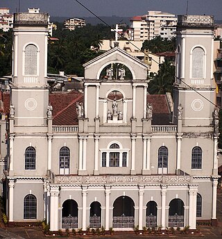
The Milagres Church is a historic Roman Catholic Church situated in the Hampankatta locality of Mangalore. The church was built in 1680 by Bishop Thomas de Castro, a Theatine from Divar, Goa. The original structure was constructed at the site of the present-day cemetery. It is one of the oldest churches in Dakshina Kannada.

<span class="mw-page-title-main">Alupa dynasty</span>

The Alupa dynasty was an ancient ruling dynasty of India. The kingdom they ruled was known as Alvakheda Arusasira and its territory spanned the coastal districts of the modern Indian state known as Karnataka. The Alupas in their prime were an independent dynasty, centuries after reigning due to the dominance of Kadambas from Banavasi, they became feudatory to them. Later they became the vassals of the Chalukyas, Rashtrakutas, Hoysalas with the change in political scenario of Southern India. Their influence over coastal Karnataka lasted for about 1200 years. There is evidence that the Alupas followed the law of matrilineal inheritance (Appekatt/Aliyasantana) since the Alupa king Soyideva was succeeded by his nephew Kulasekhara Bankideva. The legendary king who is credited with introducing matrilineality in Alva Kheda|Tulu Vishaya Kheda is named Bhuta Alupa Pandya The descendants of this dynasty still survive to this date and have spread in the karavali region and they are widely referred to as the Bunt. The Bunts follow Matrilineality instead of the common Patrilineality, and are said to be Nagavanshi Kshatriyas by their maternal origin. They can be identified with their surnames such as Shetty, Rai, Hegde, Alva, Chowta etc. Even though most Bunt are Hindus by faith now, The sizeable section of the community still follows Jainism and they are called Jain Bunt The last Alupa king to have ruled is Kulasekharadeva Alupendradeva whose inscription dated 1444 CE have been found in Mudabidri Jain Basadi.

<span class="mw-page-title-main">Kasaragod district</span> District in Kerala, India

Kasaragod is one of the 14 districts in the southern Indian state of Kerala. Its northern border Thalappady is located just 9 km south to Ullal, which is the southernmost portion of the major port city Mangalore, on the southwestern Malabar coast of India.

The History of Mangalorean Catholics comprises three major eras. The first era consists of the cultural heritage shaped by Indo-Aryan migration into the Indus valley, later the migration to Govapuri and other prominent areas of the Konkan region, possibly due to a natural disaster that caused the drying up of the Sarasvati. Also, the various invasions and the political upheavals that followed in the pre-Partition eras of the northwest Indian subcontinent might be responsible for migration to Konkan in Western India. The second era was the legacy of Lusitanian culture, from the conversion of their Konkani ancestors to Roman Catholicism in the colonies of the Portuguese in Goa and Bombay, and the final era being the migration of the Roman Catholics in Goa to Mangalore and other parts of South Canara between the mid-16th and mid-18th centuries, forming a unique Mangalorean Catholic identity, and the subsequent growth and development of the community. Four centuries of living in South Canara gave these Catholics an identity of their own, distinct from Goans and Bombay East Indians.

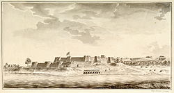
The Captivity of Mangalorean Catholics at Seringapatam (1784–1799) was a 15-year-long imprisonment of Mangalorean Catholics and other Christians at Seringapatam, in the Carnataca region of India by Tippu Sultan; who was the de facto ruler of the Kingdom of Mysore following its usurpation. Estimates of the number of captives range from 30,000 to 80,000, but the generally accepted figure is 60,000, as stated by Tippu himself in the Sultan-ul-Tawarikh. The captivity was the most disconsolate period in the community's history.

<span class="mw-page-title-main">North Malabar</span> Geographical / Historical Area in India

North Malabar refers to the geographic area of southwest India covering the state of Kerala's present day Kasaragod, Kannur, and Wayanad districts, and the taluks of Vatakara and Koyilandy in the Kozhikode District of Kerala and the entire Mahé Sub-Division of the Union Territory of Puducherry. Traditionally North Malabar has been defined as the northern portion of the erstwhile Malabar District which lies between Chandragiri River and Korapuzha River. The region between Netravathi River and Chandragiri River, which included the portions between Mangalore and Kasaragod, are also often included in the term North Malabar, as the Kumbla dynasty in the southernmost region of Tulu Nadu, had a mixed lineage of Malayali Nairs and Tuluva Brahmins.

<span class="mw-page-title-main">Tulu Nadu state movement</span> Formation of separate Tulu Nadu state from Karnataka and Kerala

Tulu Nadu State movement is aimed at increasing Tulu Nadu's influence and political power through the formation of separate Tulu Nadu state from Karnataka and Kerala. Tulu Nadu is a region on the south-western coast of India. It consists of the Dakshina Kannada and Udupi districts of Karnataka and Kasargod district up to the Chandragiri river in Kerala. The Chandragiri River has traditionally been considered a boundary between Tulu Nadu and Kerala from the fourth century AD onwards. The first call for a separate Tulu Nadu state was made just after the Quit India Movement in 1942 by Srinivas Updhyaya Paniyadi, a banker and a press owner from Udupi. Mangalore is the largest and the chief city of Tulu Nadu. Tulu activists have been demanding a separate Tulu Nadu state since the late 2000s, considering language and culture as the basis for their demand.

Participation of Mangalorean Catholics in the Indian Independence Movement recounts the community's role in the Indian Independence Movement.

<span class="mw-page-title-main">Mysorean invasion of Malabar</span>

The Mysorean invasion of Malabar (1766–1792) was the military invasion of the Malabar region of Kerala, including the territories of the Zamorin of Calicut, by the then-de facto ruler of the Kingdom of Mysore, Hyder Ali. After the invasion, the Kingdom of Cochin to the south of Malabar became a tributary state of Mysore.

<span class="mw-page-title-main">St. Paul's Church, Mangalore</span> Church in Mangalore, India

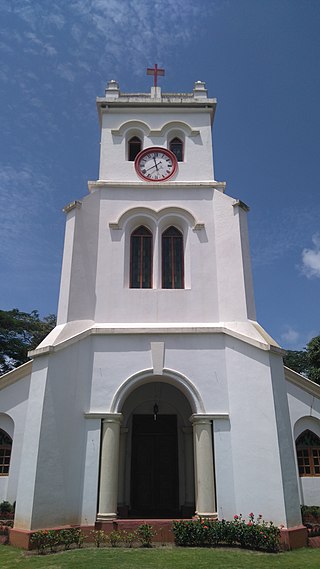
St. Paul's Church is an Anglican church in Mangalore, India.

<span class="mw-page-title-main">History of Kasaragod</span>

Kasaragod District is the northernmost district in the southwestern Indian coastal state of Kerala. The district has a long history starting from pre-historic times to the modern period.

Wayanad district, which is home to Edakkal Caves, has human settlement from prehistoric era. Wayanad is the sole Plateau in Kerala. The tribal dialects of Wayanad like the Ravula language and the Paniya language are closely related to Malayalam.

References

  1. "Worst-Case Scenario". The Times of India . 30 November 2006. Archived from the original on 14 March 2012. Retrieved 25 August 2008.
  2. Kunal Bhatia (26 February 2008). "Mangalore: Of cultural institutions, tiles and religious spots". Mumbai Mirror . Archived from the original on 21 November 2011. Retrieved 25 August 2008.
  3. 1 2 3 4 5 Gavin Shatkin (14 August 2013). "Chapter 10: Planning Mangalore: Garbage Collection in a Small Indian City". Contesting the Indian City: Global Visions and the Politics of the Local. John Wiley & Sons. ISBN   978-1-118-29584-7.
  4. Fedrick Sunil Kumar N.I (2006). "Chapter 6 : The Basel Mission in South Canara" (PDF). The basel mission and social change-Malabar and south canara a case study (1830–1956)" (PhD). University of Calicut.
  5. K. Puttaswamaiah (1980). Economic Development of Karnataka: A Treatise in Continuity and Change. Oxford & IBH. p. 33.
  6. Narayanan, M. G. S. Perumāḷs of Kerala. Thrissur (Kerala): CosmoBooks, 2013. 483.
  7. 1 2 3 4 5 6 7 Bhat, N. Shyam (1998). South Kanara, 1799–1860: a study in colonial administration and regional response. Mittal Publications. ISBN   978-81-7099-586-9.
  8. Ghosh 2002 , p.  189
  9. Lee 1829 , Perils and detours in Malabar
  10. 1 2 A. Wahab Doddamane (1993). Muslims in Dakshina Kannada: A Historical Study up to 1947 and Survey of Recent Developments. Green Words Publication.
  11. Kamath, J. (16 September 2002). "Where rocks tell a tale". The Hindu Business Line . Archived from the original on 22 September 2013. Retrieved 8 July 2008.
  12. Muthanna, I. M. (1977). Karnataka, History, Administration & Culture. Lotus Printers. p. 235.
  13. A. Sreedhara Menon. Kerala History and its Makers. D C Books (2011)
  14. A G Noorani. Islam in Kerala. Books
  15. Roland E. Miller. Mappila Muslim Culture SUNY Press, 2015
  16. South Kanara District Gazetteer 1973 , p. 62
  17. Thornton 1859 , p.  114
  18. Thornton 1859 , p.  170
  19. Lal 2002 , p. 22
  20. Forrest 1887 , pp. 314–316
  21. Raghuram, M. (18 July 2007). "Mangaluru: it has come a long way". The Hindu . Archived from the original on 8 November 2012. Retrieved 27 July 2008.
  22. Townsend 1867 , p.  628
  23. Riddick 2006 , p.  28
  24. 1 2 Prabhu 1999 , p. 152
  25. Raghuram, M. (18 June 2005). "Feeling on top of the world". The Hindu . Archived from the original on 8 November 2012. Retrieved 22 August 2008.
  26. 1 2 N. Shyam Bhat (2001). Judiciary and Police in Early Colonial South Kanara, 1799–1862. Mittal Publications. ISBN   978-81-7099-820-4.
  27. Farias, Kranti K. (1999). The Christian Impact on South Kanara. Church History Association of India.
  28. Monteiro, John B (8 January 2014). "Last of Italian Jesuits in Mangalore dies in his homeland". Daijiworld Media . Retrieved 1 March 2015.
  29. "Mangalore was once the starting point of India's longest rail route". The Hindu . 29 October 2007. Archived from the original on 14 September 2011. Retrieved 19 March 2008.
  30. "States Reorganisation Act 1956". Commonwealth Legal Information Institute. Archived from the original on 16 May 2008. Retrieved 1 July 2008.
  31. South Kanara District Gazetteer. Karnataka State Gazetteer. Vol. 12. Gazetteer Department (Government of Karnataka). 1973.
  32. Damodar Panda (1991). Cargo Handling in the Major Ports of India. Minerva Associates (Publications). p. 30. ISBN   978-81-85195-33-9.
  33. Sharma, Ravi. "Industrial leap". Frontline . 24 (19 ( 22 Sep.-Oct. 05, 2007)).
  34. "New names invoke a hoary past". The Times of India . 19 October 2014. Retrieved 23 February 2015.
  35. "Chapter 16 – the Kingdoms of the South".
  36. "Cosmas Indicopleustes, Christian Topography (1897) pp. 358–373. Book 11". The Tertullian Project. Retrieved 24 May 2007.
  37. "Kodungallur – The Cradle of Christianity in India". Indian Christianity.com. Retrieved 24 May 2007.
  38. Viswa. "My Research into Lost Civilization of Tulu". Tulu Research Institute for Esoteric Physics. Retrieved 20 March 2007.
  39. 1 2 3 "Mangalore-Brief History". Mangalore City Corporation. Archived from the original on 24 March 2008. Retrieved 19 March 2008.
  40. "The Kadambas of Banavasi". OurKarnataka.Com, Inc. Retrieved 19 March 2008.
  41. "Alupa Dynasty". india9.com.
  42. "A Quick Guide to the World History of Globalization". School of Arts & Sciences – University of Pennsylvania. Retrieved 4 June 2007.
  43. Mr. Arthikaje. "Karnataka History". OurKarnataka.Com, Inc. Retrieved 1 March 2008.
  44. Vinay Pais. "Copper Inscriptions of Vijayanagar Empire Found in Barkur". Daijiworld Media Pvt Ltd Mangalore. Retrieved 19 March 2008.
  45. "Sultan Battery – built by Tippu Sultan was known as Sultan's Battery". MangaloreMithr.com. Retrieved 6 March 2008.
  46. "St. Mary's Island Beach". BharatOnline.com. Retrieved 14 January 2008.
  47. "Mangalore". BookRags. Retrieved 19 March 2008.
  48. "Tipu Sultan". Renaissance.com. Archived from the original on 9 June 2007. Retrieved 4 June 2007.
  49. "Treaty of Mangalore between Tipu Sultan and the East India Company, 11 March 1784". Project South Asia. Archived from the original on 21 June 2008. Retrieved 19 March 2008.
  50. "Second Anglo – Mysore War (1780–1784)". Sify Ltd. Archived from the original on 30 September 2007. Retrieved 19 March 2008.
  51. "1799: Fourth Anglo-Mysore War". Sify Ltd. Archived from the original on 12 August 2007. Retrieved 19 March 2008.
  52. John B. Monteiro. "Mangalore: Comtrust Carries on Basel's Mission". Daijiworld Media Pvt Ltd Mangalore. Archived from the original on 28 September 2011. Retrieved 21 March 2008.
  53. "Mangalore". Ukisoft, Corp. Archived from the original on 17 April 2008. Retrieved 18 March 2008.

Works cited