Kingborough Council, Tasmania

Last updated
Kingborough Council
Tasmania
Map showing the Kingborough local government area.
Coordinates 43°11′36″S147°15′48″E / 43.1932°S 147.2632°E / -43.1932; 147.2632 Coordinates: 43°11′36″S147°15′48″E / 43.1932°S 147.2632°E / -43.1932; 147.2632
Population35,853 (2016 census) [1]
 • Density49.8/km2 (129/sq mi)
Established20 August 1907 [2]
Area717 km2 (276.8 sq mi)
MayorDean Winter
Council seat Kingston
Region Kingston and Channel
State electorate(s) Franklin, Clark
Federal Division(s) Franklin, Denison
Kingborough council logo.jpg
Website Kingborough Council
LGAs around Kingborough Council:
Glenorchy Hobart Hobart
Huon Valley Kingborough Council Storm Bay
Huon Valley Southern Ocean Southern Ocean
Kingborough LGA Tasmania locator map inset.svg

Kingborough Council is a local government body in Tasmania, and one of the five municipalities that constitutes the Greater Hobart Area. Kingborough is classified as an urban local government area and has a population of 35,853, it covers the transition from the southern urban areas of Hobart through Kingston, as well as encompassing Bruny Island.

Local government in Australia is the third tier of government in Australia administered by the states and territories, which in turn are beneath the federal tier. Local government is not mentioned in the Constitution of Australia and two referenda in the 1970s and 1980s to alter the Constitution relating to local government were unsuccessful. Every state government recognises local government in their respective constitutions. Unlike Canada or the United States, there is only one level of local government in each state, with no distinction such as cities and counties.

Tasmania island state of Australia

Tasmania is an island state of Australia. It is located 240 km (150 mi) to the south of the Australian mainland, separated by Bass Strait. The state encompasses the main island of Tasmania, the 26th-largest island in the world, and the surrounding 334 islands. The state has a population of around 526,700 as of March 2018. Just over forty percent of the population resides in the Greater Hobart precinct, which forms the metropolitan area of the state capital and largest city, Hobart.

Hobart City in Tasmania, Australia

Hobart is the capital and most populous city of the Australian island state of Tasmania. With a population of approximately 225,000, it is the least populated Australian state capital city, and second smallest if territories are taken into account. Founded in 1804 as a British penal colony, Hobart, formerly known as Hobart Town or Hobarton, is Australia's second oldest capital city after Sydney, New South Wales. Prior to British settlement, the Hobart area had been occupied for possibly as long as 35,000 years, by the semi-nomadic Mouheneener tribe, a sub-group of the Nuennone, or South-East tribe. The descendants of these Aboriginal Tasmanians often refer to themselves as 'Palawa'.

Contents

Etymology

The origin of Kingborough Council is a simple derivation from the name of the main town. The name Kingston was suggested by Mr Lucas in 1851, and the area had been known as Brown's River before then. Why he suggested this name is unknown. Mr Lucas' parents had been raised in England near New Kingston, they had come from Norfolk Island where the capital was Kingston or it might have been named after the Governor of New Norfolk Philip Gidley King. [3]

Philip Gidley King British Colonial governor

Captain Philip Gidley King was the third Governor of New South Wales, and did much to organise the young colony in the face of great obstacles.

History

Europeans settled in the Kingborough Council's district in 1808 at Brown's River (Promenalinah), named after Robert Brown, botanist in 1804. The town and district were both known as Brown's River during the earliest periods of settlement. The Lucas family settled the area and built The Red House, a prominent mansion which is now Kingston Golf Club. Early Kingston developed primarily around The Red House. Development of Kingborough was slow and the first post office opened only in the 1840s. The first road to Hobart, Proctors Road, was opened in 1835. [3]

Kingston was proclaimed a town in 1851. The town's name was suggested by the then Police Magistrate, a member of the Lucas family. By 1890 Kingston had a population of 249. When proclaimed on 20 August 1907, the Kingborough Municipality comprised 3 wards: Kingston, Margate and Longley. On 2 April 1993 Kingborough absorbed the former municipality of Bruny. [2]

In 1877 Keen's Curry was invented in the municipality. [3]

Keen's is a brand of McCormick Foods Australia Pty Ltd, the Australian branch of American food company, McCormick & Co. Inc. McCormick Foods Australia is located in Melbourne and is a producer of food products for both the retail and food service industries.

The area developed as a holiday area, especially the suburbs of Kingston Beach and Blackmans Bay. Margate and Kettering operated fishing fleets and Taroona created had a manufacturing industry, primarily through Taroona Shot Tower. [3] Sandfly became a center for small fruits and apple orcharding. [4] The decline of the apple industry progresses during the 1960s, but the industry collapsed entirely following the 1967 Tasmanian fires, when much of the municipality was devastated [5] and most orchards burnt down. [3] A memorial to the 62 fatalities of the fire was constructed in Snug following the fire, where 80 of the towns 120 buildings burned [6] and a permanent exhibition is present at the Channel Heritage Center.

Kingston Beach, Tasmania Suburb of Hobart, Tasmania, Australia

Kingston Beach is a suburb of the greater Hobart area, capital of Tasmania, Australia. It is located on the Derwent River at the mouth of Browns Rivulet. It was originally known as Browns River Beach in the 1850s. Kingston Beach was a regularly photographed location in the twentieth century.

Sandfly, Tasmania Town in Tasmania, Australia

Sandfly is a suburb in the Kingborough Council local government area in Tasmania, Australia. A region of the Franklin Electorate, Sandfly is a historic area that sits between the suburbs of Longley, Lower Longley, Allens Rivulet, Margate, Leslie Vale and Kaoota. The population of Sandfly in 2011 was 156.

1967 Tasmanian fires series of bushfires in Australia

The 1967 Tasmanian fires were an Australian natural disaster which occurred on 7 February 1967, an event which came to be known as the Black Tuesday bushfires. They were the most deadly bushfires that Tasmania has ever experienced, leaving 62 people dead, 900 injured and over seven thousand homeless.

Demographics

Localities and smaller towns of the region include Taroona, Kettering, Margate, Snug, Blackmans Bay and Woodbridge. Kingston is classified as urban, fringe and medium (UFM) under the Australian Classification of Local Governments. [7]

See also

Related Research Articles

Councils of Tasmania are the 29 administrative districts of the Australian state of Tasmania. Local government areas (LGAs), more generally known as councils, are the tier of government responsible for the management of local duties such as road maintenance, town planning and waste management.

Kingston, Tasmania Town in Tasmania, Australia

Kingston is a town on the outskirts of Hobart, Tasmania, Australia. Nestled 12 km south of the city between and around several hills, Kingston is the seat of the Kingborough Council, and today serves as the gateway between Hobart and the D'Entrecasteaux Channel region, which meets the Derwent River nearby. It is one of the fastest growing regions in Tasmania. The Kingston-Huntingfield statistical area had an estimated population of 11,200 in June 2012.

Margate, Tasmania Town in Tasmania, Australia

Margate is a small seaside town on the Channel Highway between North-West Bay and the Snug Tiers, 7 kilometres (4 mi) south of Kingston in Tasmania, Australia.

Bruny Island island off coast of Tasmania

Bruny Island is a 362-square-kilometre (89,000-acre) island located off the south-eastern coast of Tasmania, Australia. The island is separated from the Tasmanian mainland by the D'Entrecasteaux Channel, and its east coast lies within the Tasman Sea. Storm Bay is located to the island's northeast. Both the island and the channel are named after French explorer Bruni d'Entrecasteaux. Its traditional Aboriginal name is lunawanna-allonah, which survives as the name of two island settlements, Alonnah and Lunawanna.

West Coast Council Local government area in Tasmania, Australia

West Coast Council is a local government body in Tasmania, covering much of the western region of the state. West Coast is classified as a rural local government area and has a population of 4,149, the major towns and localities of the region include Strahan, Rosebery, Queenstown and the principal town of Zeehan.

Central Highlands Council Local government area in Tasmania, Australia

Central Highlands Council is a local government body in Tasmania, encompassing the Central Highlands region of the state. Central Highlands is classified as a rural local government area and has a population of 2,141, the two largest towns are Bothwell and Hamilton.

City of Hobart Local government area in Tasmania, Australia

Hobart City Council is a local government body in Tasmania, covering the central metropolitan area of the state capital, Hobart. The Hobart local government area has a population of 50,439 and includes the suburbs of New Town, Sandy Bay and most of Fern Tree and Mount Nelson.

City of Glenorchy Local government area in Tasmania, Australia

Glenorchy City Council is a local government body in Tasmania, and one of the five municipalities that constitutes the Greater Hobart Area. The Glenorchy local government area has a population of 46,253, covering the suburbs north of central Hobart on the western shore of the Derwent River, including its namesake suburb, Glenorchy.

Taroona Suburb of Hobart, Tasmania, Australia

Taroona is a major residential suburb approximately 15 minutes drive from the centre of Hobart, Tasmania on the scenic route between Hobart and Kingston. Although on the edges of the City of Hobart, Taroona is actually part of the municipality of Kingborough.

Electoral division of Huon Tasmanian Legislative Council electoral division

The Electoral division of Huon is one of the 15 electoral divisions in the Tasmanian Legislative Council. It was created in 1999, however similar electorates of this name have existed since 1900, and members of the Tasmanian upper house for this region appear to have been elected since 1856.

DEntrecasteaux Channel water between Bruny Island and Tasmania

The D'Entrecasteaux Channel is a body of water located between Bruny Island and the south-east of the mainland of Tasmania, Australia. The channel is the mouth for the estuaries of the Derwent and the Huon Rivers and empties into the Tasman Sea of the South Pacific Ocean. It was sighted by Abel Tasman in 1642 and surveyed in 1792 by Bruni d'Entrecasteaux.

Brighton Council is a local government body in Tasmania, situated in the south-east of the state, north of Hobart. The Brighton local government area is classified as urban and has a population of 16,512, it is based in the town of Brighton but also covers the far northern Hobart suburbs of Bridgewater, Gagebrook, Honeywood and Old Beach.

Huon Valley valley and geographic area located in southern Tasmania, Australia

The Huon Valley, or simply the Huon is a valley and geographic area located in southern Tasmania, Australia. The largest town is Huonville, with other smaller towns spread across the area. It includes Australia's most southern permanent settlement at Southport. The Huon Valley Council area had a population of 15,140 in 2011. Famed for its apple growing, the Valley was first settled by British colonists in the 1820s; prior to settlement the Huon Valley area was inhabited by the Palawa people.

Huntingfield, Tasmania Suburb of Hobart, Tasmania, Australia

Huntingfield is an outer suburb of the greater Hobart area, bordering Blackmans Bay and Kingston. The area was created in the late 1980s. Located in Huntingfield are Tarremah Steiner School, St Aloysius Catholic College and Kingborough Family Church. In 2017 its houses were the fastest selling in Australia, which was attributed to reasonable prices, and a good range of services.

The Channel Highway is a regional highway that travels south from Hobart To Huonville, Tasmania, Australia. The Channel Highway starts from the end of Sandy Bay Road and travels south toward Huonville via Taroona, Kingston, Huntingfield, Margate, Kettering, Woodbridge and Cygnet. The shortest way from Hobart to Huonville is via the Huon Highway. Prior to the construction of the Southern Outlet the Channel Highway was the main route used to get to Kingston and other southern towns.

The electoral district of Kingborough was an electoral district of the Tasmanian House of Assembly. It was based in the region to the immediate south of Tasmania's capital city, Hobart, and included the Huon Valley towns of Cygnet, Huonville, Kettering, Margate and Sandfly.

Sandfly Colliery Tramway

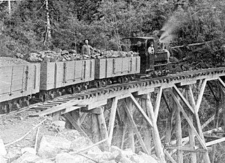
The Sandfly Colliery Tramway was a 20 km (12 mi), 2 ft narrow gauge tramway linking the Kaoota Mine to Margate, Tasmania. Constructed in 1905–06, the Tramway climbed 457 m (1,499 ft) above sea level and crossed ten bridges. After coal mining ceased the tramway was used to transport logs, fruit and passengers. The line was lifted and abandoned in 1922 after bushfires destroyed several bridges along the line. Currently, 6 km (3.7 mi) of the old track is used as cycling/walking tracks, while the remainder of the old line is on private property.

Shot Tower, Taroona

The Shot Tower at Taroona is a historic building shot tower between Hobart and Kingston, Tasmania. It was designed and built by Joseph Moir in 1870 in only eight months. One of only three remaining shot towers in Australia, it is alleged to be the tallest remaining shot tower in the world and the tallest ever built in the Southern Hemisphere, which is disputed by the Clifton Hill Shot Tower.

References

  1. Australian Bureau of Statistics (27 June 2017). "Glenorchy (C)". 2016 Census QuickStats. Retrieved 23 November 2017. Blue pencil.svg
  2. 1 2 "Agency Details: Kingborough Municipal Council". search.archives.tas.gov.au. Tasmanian Government. Retrieved 11 June 2018.
  3. 1 2 3 4 5 "History of Kingston - Early Settlement". kingborough.tas.gov.au/. Kingborough Council. Retrieved 5 November 2015.
  4. Gardam, Julie (2014). Sandfly and surrounds (2nd ed.). Snug, Tasmania. Retrieved 1 August 2015.
  5. "Kingborough's rich heritage revealed". heritage.tas.gov.au. Heritage Tasmania. Retrieved 5 November 2015.
  6. "Snug Bushfire MemorialPrint". monumentaustralia.org.au. Monument Australia. Retrieved 5 November 2015.
  7. "Local government national report 2014-2015". regional.gov.au. Australian Government. Retrieved 8 June 2018.