This is an incomplete list of volcanic eruptions in Iceland. Please see External links below for databases of Icelandic eruptions which include over 530 events.
There are about 32 volcanic systems in Iceland. Volcanic system means a volcano-tectonic fissure system and – very often a bigger volcano, a so-called central volcano which in most cases is a stratovolcano and may contain a caldera.[2][3]
- Bárðarbunga; An active stratovolcano located under the Vatnajökull glacier. The second highest mountain in Iceland, 2,009 metres (6,591ft) above sea level, and part of a volcanic system that is approximately 200 kilometres (120mi) long and 25 kilometres (16mi) wide. Historically there are large eruptions every 250–600 years. Part of the East volcanic zone (EVZ).
- Dyngjufjöll, a volcanic mountain range in the northeast of Iceland. It belongs to the Askja volcanic system or the volcanic system, (sometimes called the (Dyngjufjöll volcanic system), and is part of the Vatnajökull National Park. The central volcano of basalt and rhyolite has its own system of crevices and fissures, which last erupted in 1961. (Part of the North volcanic zone (NVZ)).
- Eldey a small island about 13 kilometres off the coast of the Reykjanes Peninsula in south west. The Eldey and Geirfuglasker volcanic systems together form the 35–40km (22–25mi) long Eldey system on the mid-Atlantic ridge. There is not a central volcano.[5]
- Eldfell, a volcanic cone on the island of Heimaey. It formed in a volcanic eruption which began without warning on the eastern side of Heimaey, in the Westman Islands, on 23 January 1973. The eruption caused a major crisis for the island and led to its temporary evacuation. Volcanic ash fell over most of the island, destroying around 400 homes, and a lava flow threatened to close off the harbour, the island's main income source via its fishing fleet. An operation was mounted to cool the advancing lava flow by pumping sea water onto it, which was successful in preventing the loss of the harbour. Part of the East volcanic zone (EVZ).
- Eldgjá, a volcano and a canyon that is part of the Katla volcano; a segment of a 40 kilometres (25 miles) chain of volcanic craters and fissure vents that extends northeast away from Katla. Part of the East volcanic zone (EVZ).
- Esja, (Esjan), a 914m (2,999ft) mountain situated in the south-west of Iceland, about ten kilometres north of Iceland's capital city Reykjavík. Esja is not a single mountain, but a volcanic mountain range, made from basalt and tuff. Esja was built up at the end of the Pleistocene with the beginning of the Ice Age. During the warm periods lava flowed, and in the cold periods ridges of tuff were built up under the glacier. The western part of the mountain range is the oldest (about 3.2million years) and the eastern part is the youngest (about 1.8million years).[6]Part of the Reykjanes volcanic zone (RVZ).
- Esjufjöll, subglacial volcano at the SE part of the Vatnajökull icecap. A strict nature reserve.[7] The volcanic system consists of the Snaehettacentral volcano with a large caldera. Most of the volcano, including the 40km2 caldera, is covered by the icecap. On the other hand, are parts of the SE flank exposed in NW-SE-trending ridges.[8] Most of the exposed rocks are mildly alkaline basalts, but there are also small amounts of rhyolitic rocks.[8]Part of the East volcanic zone (EVZ) (or Oræfi Volcanic Belt.[9][10])
- Grímsey, is a small Icelandic island, 40 kilometres (20 nautical miles) off the north coast of the main island of Iceland, where it straddles the Arctic Circle.[25] (However, due to long-term oscillations in the Earth's axis, the Arctic Circle is shifting northward by about 14.5 metres (48ft) per year (varying substantially from year to year due to the complexity of the movement). As of 2020, the place where the line crosses the island is close to the northern tip and by the middle of the 21st century it will pass north of Grimsey altogether.) Part of the Kolbeinsey Ridge (KR).
- Kerið is a volcanic crater lake located in the Grímsnes area in south Iceland, along the Golden Circle. It is one of several crater lakes in the area, known as the Western Volcanic Zone, created as the land moved over a localized hotspot, but it has the most visually recognizable caldera still intact. The caldera, like the other volcanic rock in the area, is composed of a red (rather than black) volcanic rock, and is approximately 55m (180ft) deep, 170m (560ft) wide, and 270m (890ft) across. Kerið's caldera is one of the three most recognisable volcanic craters because at approximately 6,500 years old, it is only half the age of most of the surrounding volcanic features. The other two are Seyðishólar and Kerhóll.
Although originally believed to have been formed by a volcanic explosion, studies of the Grímsnes region failed to find any supporting evidence. So it is now believed that Kerið was a cone volcano which erupted and emptied its magma reserve. Once the magma was depleted, the weight of the cone collapsed into the empty magma chamber. The current pool of water at the bottom of the crater is at the same level as the water table and is not caused by rainfall.[26]
- Grímsvötn; an active volcano with a (partially subglacial) fissure system located in Vatnajökull National Park. Including the Skaftá eruption of 1783, Grímsvötn is probably the most eruptive volcano system in Iceland. The Laki/Lakagígar lava field alone is estimated to have produced about 15 cubic kilometres (3.6cumi) of lava. Grímsvötn has probably had more than 30 eruptions in the last 400 years, and produced around 55 cubic kilometres (13cumi) over the last 10,000 years.[1]Part of the East volcanic zone (EVZ).
- Hekla; an active stratovolcano in the south. It is one of the most active volcanoes; over 20 eruptions since the year 1210.[27] During the Middle Ages it was known as the "Gateway to Hell". Part of a volcanic ridge, 40km (25mi) long. Part of the East volcanic zone (EVZ).
- Hengill, A volcanic table mountain the southwest, to the south of Þingvellir. The volcano is still active, evidenced by its numerous hot springs and fumaroles.[30]Part of the Reykjanes volcanic zone (RVZ).
- Hofsjökull, subglacial volcano is a shield type with caldera, formed during the Last Glacial Period. The Hofsjökull glacier is the third largest ice cap after Vatnajökull and Langjökull. The largest active volcano in the country, situated in the west of the Highlands [32][33]
- Hvalbakur. a small, uninhabited island is the easternmost point of Iceland. Located in the Austurland region, 35 kilometres (22mi) offshore, it is 200 metres (660ft) long and up to 100 metres (330ft) wide, with its highest point 5 metres (16ft) above sea level. It appears on maps from 1761[35]
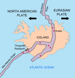
- Iceland hotspot; a hotspot which is partly responsible for the high volcanic activity which has formed the Iceland Plateau and the island of Iceland. Iceland's location astride the Mid-Atlantic Ridge, where the Eurasian and North American Plates are moving apart, is partly responsible for this intense volcanic activity, but an additional cause is necessary to explain why Iceland is a substantial island while the rest of the ridge mostly consists of seamounts, with peaks below sea level.
As well as being a region of higher temperature than the surrounding mantle, the hotspot is believed to have a higher concentration of water. The presence of water in magma reduces the melting temperature, which may also play a role in enhancing Icelandic volcanism.
- Jólnir, was a volcanic island off the south coast between December, 1965 and July, 1966. A vent of Surtsey, along with Syrtlingur and Surtla. Over the following eight months it appeared and disappeared several times, as wave erosion and volcanic activity alternated in dominance, until oceanic erosion led to its final disappearance.[38][39]Part of the East volcanic zone (EVZ).
- Kolbeinsey, is a small basaltislet, devoid of vegetation, in the Greenland Sea located 105 kilometres (55 nautical miles) off the northern coast of Iceland, 74km (40nmi) north-northwest of the island of Grímsey. It is the northernmost point of Iceland and lies north of the Arctic Circle.[43] Kolbeinsey is subject to rapid wave erosion and is expected to disappear in the near future. Erosion rate data from 1994 suggested that this would happen around 2020.[44]As of April2021[update], two small skerries remained visible at low tide.[45][46]
Kolbeinsey is the only sub-aerial expression of this portion of the Mid-Atlantic Ridge. It formed during the late-Pleistocene (from circa 2.58 million to 11,700 years ago.) (or Holocene). Dredged glass shards indicate submarine eruptive activity during the late-Pleistocene until at least 11,800 radiocarbon years ago.[47]Part of the Kolbeinsey Ridge (KR).
- Kolbeinsey Ridge, is a segment of the Mid-Atlantic Ridge located in the Arctic Ocean. It is bounded to the south by the Tjörnes Fracture Zone, which connects the submarine ridge to the on-shore Northern Volcanic Zone rifting center in eastern Iceland.[48] The volcanic islands Kolbeinsey and Grímsey lie along the ridge. Part of the Kolbeinsey Ridge (KR).
- Krakatindur, a volcano in the county of Rangárvallasýsla, located east of Hekla, it is part of the Nýjahraun lava field. It is 858 meters high and last erupted in 1878.[50][51][52](Part of the East volcanic zone (EVZ)).
- Kverkfjöll, a mountain range situated on the north-eastern border of the Vatnajökull glacier, between the Vatnajökull glacier and the Dyngjufjöll mountains. Part of the North volcanic zone (NVZ).
- Laki. Lakagigar is a volcanic fissure that bisects Laki mountain in the western part of Vatnajökull National Park. Lakagígar is part of the Grímsvötn volcanic system. The pollution from the 1783 eruption led to the deaths of over 50% of Iceland's livestock, and the destruction of the vast majority of crops. The resulting famine then killed approximately a quarter of the island's human population.[55] The eight-month emission of sulfuric aerosols resulted in one of the most important climatic and socially significant natural events of the last millennium.[56][57] triggering up to 6 million deaths worldwide. Part of the East volcanic zone (EVZ).
- Langjökull, (long glacier) is the second largest ice cap in Iceland, (953km2), after Vatnajökull. It is situated in the west of the interior or Highlands of Iceland and can be seen clearly from Haukadalur. The volume is 195km3 and up to 580m (1,900ft) thick. The highest point (Baldjökull) is about 1,450m (4,760ft) above sea level. The largest recorded surface area was in 1840.[60]Part of the West volcanic zone (WVZ). Associated volcanoes: Hveravellir, Prestahnúkur
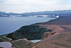
- The Mývatn fires were a series of fires at Krafla that raged from 1724 to 1729. Lava flowed into Mývatn and the explosive crater Víti at Krafla was formed.
- Reykjanes, The "Reykjanes Volcanic System" is one of the volcanic systems on Reykjanes Peninsula, and consists of (volcanic and tectonic) fissures and faults directed mostly NE-SW. It is part of Reykjanes Volcanic Belt like the 3-6 (depending on author) other volcanic systems on Reykjanes Peninsula.[66][67][68][69] No volcanic eruption had occurred for 815 years on the Peninsula until 19March 2021 when a fissure vent appeared in Geldingadalir to the south of Fagradalsfjall mountain.[70][71]Part of the Reykjanes volcanic zone (RVZ). See Fagradalsfjall in index.
- Sundhnúkur eruptions, near Grindavik on the Reykjanes peninsula. Eruptions from 18 December 2023. No volcanic eruption had occurred for 815 years on the Reykjanes Peninsula until 19March 2021, - See Fagradalsfjall index)Part of the Reykjanes volcanic zone (RVZ).
- Surtsey, A volcanic island located in the Vestmannaeyjararchipelago off the southern coast. It was formed in a volcanic eruption which began 130 metres (430 feet) below sea level, and reached the surface on 14 November 1963. The eruption lasted until 5 June 1967, when the island reached its maximum size of 2.7km2 (1.0sqmi).[74] The most recent survey (2007) shows the island's maximum elevation at 155m (509ft) above sea level.[75]Part of the East volcanic zone (EVZ).
- Thrihnukagigur (Thríhnúkagígur), (Three Peaks Crater) is a dormant volcano in the volcanic system of Brennisteinsfjöll near Reykjavík, Iceland.[80] Covering a 3,270 square metres (35,200sqft) area and a depth of 213 meters (699ft),[81] it has not erupted in the past 4000 years.[82] It opened for tourism in 2012, the only volcano in the world where visitors can take an elevator into the magma chamber. The magma that would normally fill the chamber and become sealed is believed to have drained away, revealing the rift beneath the surface.[83]Part of the Reykjanes volcanic zone (RVZ).
- Tindfjallajökull is a stratovolcano in the south of Iceland.[72] It has erupted rocks of basaltic to rhyolitic composition, and a 5-km-wide caldera was formed during the eruption of the 54,000-year-old Thórsmörk Ignimbrite. It is capped by a glacier of 19km2.[84] Its highest peak is Ýmir.
- Tjörnes, Fracture Zone is a submarine volcano situated northeast of Iceland, between the fjords of Öxarfjörður and Skjálfandi. It is a series of underwater fissure vents that last erupted from 1867 to 1868. The Tjörnes Fracture Zone (TFZ) connects the North Volcanic Zone to the Kolbeinsey Ridge (KR), which is part of the Mid-Atlantic Ridge. It contains its own volcanic systems, which are smaller than those in the Mid-Iceland Belt. It is one of two major and active transform faults zones striking west-northwest in northern and southern Iceland.[85] The Tjörnes and Reykjanes Fracture Zones are found striking about 75°N to 80°W.[86]
- Trölladyngja, Situated in the Ódáðahraunlava field, it is the biggest Icelandic shield volcano, with a height of 1,468 metres (4,816ft)[90] and rising almost 600metres above the surrounding desert and lava fields. It is about 10kilometres in diameter. Its oblong crater is about 1,200 to 1,500metres in length, 500metres broad, and about 100metres deep. Most of its lava fields have flowed in a northerly direction, with one branch of it reaching the valley of Bárðardalur, a distance of roughly 100km. It is not to be confused with the Krýsuvík-Trölladyngja volcanic system on the Reykjanes Peninsula. (Part of the North volcanic zone (NVZ))
- Viðey, (caldera,[citation needed]) at Reykjavík. About two million years ago during the Pleistocene, Viðey was an active volcano with a massive caldera.[95] The remains of the caldera are much larger than the modern island itself, with the island near the caldera's center. The rest of the caldera underlies a large part of what is now Kollafjörður.[96] The underwater eruption that formed Viðey island stopped circa 9,000 years ago. (Part of the Reykjanes volcanic zone (RVZ))
Dates are approximate. Please see individual articles that may have more date detail.
16,000,000 years ago - the oldest known rock in Iceland was formed in a lava eruption. The age of the basaltic strata from west to east is 16–10 million years.[97][98] (See Geology of Iceland - Origins)
Circa 3,200,000 years ago (Plio-Pleistocene) - Esjan (Esja) - The western part is about 3.2million years and the eastern part is about 1.8million years. The movements of the plate boundaries are continually moving the strata to the west and away from the active volcanic zone.[6] Two volcanoes were active in the Reykjavík region, Viðey volcano and Stardals volcano.[citation needed] They partially formed Esja (Esjan); the smaller mountains near Reykjavík; plus the islands and small peninsulas like Viðey and Kjalarnes.[6][99](Part of the Reykjanes volcanic zone (RVZ))
2,600,000-9,000 years ago - Viðey About two million years ago during the Pleistocene, Viðey was an active volcano with a massive caldera.[95] The remains of this caldera are much larger than the modern island itself, with the island near the caldera's center. The rest of the caldera underlies a large part of what is now Kollafjörður.[96] The underwater eruption that formed Viðey island stopped circa 9,000 years ago. (Part of the Reykjanes volcanic zone (RVZ))
2,500,000-11,000 years ago - Hofsjökull, subglacial volcano is a shield type with caldera. The third largest ice cap after Vatnajökull and Langjökull and the largest active volcano in the country, situated in the west of the Highlands [32][102][103]
Circa 1,800,000 years ago (Plio-Pleistocene) - Esjan (Esja) - The western part is about 3.2million years and the eastern part is about 1.8million years. The movements of the plate boundaries are continually moving the strata to the west and away from the active volcanic zone.[6] Two volcanoes were active in the Reykjavík region, Viðey volcano and Stardals volcano.[citation needed] They partially formed Esja (Esjan); the smaller mountains near Reykjavík; plus the islands and small peninsulas like Viðey and Kjalarnes.[6][99](Part of the Reykjanes volcanic zone (RVZ))
42,000-12,400 years ago - Sveifluháls, volcanic melting of glacier ice induced the formation of one or more subglacial meltwater lakes. Dropping overburden pressures led to the eruption of vitric phreatomagmatictuff.[105]
Circa 10,600 years ago - Katla. It is thought that Katla is the source of more than 6 to 7 cubic kilometers (1.4 to 1.7cumi) of tephra[106][107][108][109] 'Vedde Ash' found at a number of sites including Vedde in Norway, Denmark, Scotland and North Atlantic cores.[110]
circa 9,000 years ago - Skjaldbreiður lava shield formed in one huge and protracted eruption.[citation needed] The lava flowed south and formed the basin of Þingvallavatn, Iceland's largest lake.
6700 BC. - the "Great Þjórsá Lava flow", the largest known effusive eruption in Iceland in the last 10,000 years, originated from the Veiðivötn (is:Veiðivötn) (area.[114] The Þjórsá lava field is up to 1,000km2 (390sqmi) in area and flowed over 100km (62mi) to the sea and forms the coast between Þjórsá and Ölfusá.[115][116](Part of the East volcanic zone (EVZ)) Note: Bárðarbunga 6600 BC is also described as "about 8,600 years ago, with a total volume of 21[4] to 30 cubic kilometres and covering approximately 950 square kilometres."[117]
Circa 5,800 BC - Hveravellir? The Kjalhraun (hraun means "lava field") lava field is about 7,800 years old.[118]
5000 BC - Hekla (H5). The first acidic eruption in Hekla. The ash layer H5 is found in soil in the central highlands and in many parts of the North. (Part of the East volcanic zone (EVZ))
Circa 6,500 BP - Kerið, is a volcanic crater lake located in the Grímsnes area. It is believed that Kerið was a cone volcano which erupted and emptied its magma reserve. Once the magma was depleted, the weight of the cone collapsed into the empty magma chamber. The pool of water at the bottom of the crater is at the same level as the water table and is not caused by rainfall.[26]
3350 BCE (?) - Prestahnúkur, volcano in the west of the Highlands of Iceland to the west of Langjökull glacier. (Part of the North volcanic zone (NVZ).
3550 BC Thórðarhyrna, An eruption in 3550 BC ± 500 years poured out 150,000,000 cubic meters of lava in the area of Bergvatnsárhraun, to the south of Thordarhyrna.[121]
3500 BC - Grímsnes, VEI 3. The Grímsneshraun lava-fields in the area cover a total of 54km2 (21sqmi). The total volume of lava produced in the lava flows of Grímsnes has been estimated at 1.2 cubic kilometres (0.29cumi). (Part of the South Iceland Seismic Zone (SISZ))
4,000 BP - Thríhnúkagígur, an eruption in the volcanic system of Brennisteinsfjöll covered an area of 3,270 square metres (35,200sqft) to a depth of 213 meters (699ft),[80][81][82] It is the only volcano in the world where visitors can take an elevator into the magma chamber. The magma that would normally fill the chamber and become sealed is believed to have drained away, revealing the rift beneath the surface. Part of the Reykjanes volcanic zone (RVZ).
1200 BC - Veiðivatnasvæði, Búrfellshraun flowed from a series of craters near Veiðivötn (is:Veiðivötn), on the one hand to Þórisós and on the other hand down with Tungná and Þjórsá all the way down to Landsveit
300 BC Mývatn, large fissure eruption pouring out basaltic lava. The lava flowed down the valley Laxárdalur to the lowland plain of Aðaldalur where it entered the Arctic Ocean about 50km (31mi) away from Mývatn. The crater row that was formed on top of the eruptive fissure is called Þrengslaborgir (or Lúdentsborgir). (Part of the North volcanic zone (NVZ))
Circa 50-350 CE Snæfellsjökull, The latest eruption took place circa 50-350 CE and released approximately 0.11km3 (144,000,000cuyd) of volcanic material. The eruption was explosive and originated from the summit crater, and may have produced lava flows.[137][138](Part of the Snæfellsnes volcanic belt (SVB))
Note. The Volcanic winter of 536 was the most severe and protracted episode of climatic cooling in the Northern Hemisphere in the last 2,000 years.[139] The source of the eruption remains to be found. Icelandic volcanos were proposed.[93][140] However, the cryptotephras dated exactly to AD 536 are geochemically distinct from Icelandic tephra,[141] and the shards in the Swiss glacier have large age uncertainty.[93]
Katla 751-763 ± 2 Hrafnkatla (AT-8 or E2) series of eruptions including large eruptions in 757 and 763 ± 2 with total tephra volume greater than 4,500km3 (1,100cumi)[142]
877 - Ash and lava eruptions in Vatnaöldur in so called "Settlement eruption" dated to 877 ± 2 CE.[142] The craters resulted from 65 kilometres (40mi) (or 42 kilometres (26mi)[91]) long volcanic fissures within the area of a lake. The mainly explosive eruptions emitted 5–10km3 (1.2–2.4cumi) of tholeiite basalt.[145][146] The first eruption since human settlement of Iceland was the Vatnaöldur (Bárðarbunga) eruption, which had a volcanic explosivity index (VEI) of 4.[72](It is part of the East volcanic zone (EVZ))
Circa 1000 - Hveravellir. A volcanic system in the Arnarvatnsheiði. The craters of this system produced the lava field Hallmundarhraun which extends some 50 kilometres (31mi) westward into the valley of the Hvítá.[154]
1158 - Hekla, second eruption. A VEI 4 eruption began on 19 January 1158 producing over 0.15km3 of lava and 0.2km3 of tephra. It is likely to be the source of the Efrahvolshraun lava on Hekla's west.[129][156](Part of the East volcanic zone (EVZ))
1226-1227 - some eruptions in Reykjanes. They are owned[clarification needed] by Yngra Stampahraun, (Klofningahraun), Eldvarpahraun, Illahraun and Arnarseturshraun. Sandy winter due to a large ash eruption at Reykjanestá and the so-called Medieval Valley fell. Famine as a result. (Part of the Reykjanes volcanic zone (RVZ))
1311 - Katla. Darkness in the Eastfjords and ash fall in many parts of the country. Major lava flow, probably on Mýrdalssandur, but sources are unclear and contradictory. Crop and hay failure the following year with associated casualties. (Part of the East volcanic zone (EVZ))
1341 - (± 1 year) Brennisteinsfjöll, a VEI-2 eruption.[157] One of the bigger lava flows, runs south to the coast at Herdísarvík bay forming lava falls on their way.[158]
1389-1390 - in and around Hekla, eruption number 7. Norðurhraun lava flows, Skarð, Tjaldastaðir and maybe more farms are subsumed.[155](Part of the East volcanic zone (EVZ))
1554 - Vondubjallar southwest of Hekla. The eruption lasted for 6 weeks in the spring. Red bells formed and from them flowed Pálssteinshraun. (Part of the East volcanic zone (EVZ))
1597 - Hekla, eruption number 9. From 3 January into the summer. Volcanic eruptions were widespread but caused little living space, although mainly in Mýrdalur. (Part of the East volcanic zone (EVZ))
1612 - Katla (and / or Eyjafjallajökull). The eruption began on 16 October, but sources do not agree on location, Katla is considered more likely. (Part of the East volcanic zone (EVZ))
1625 - Katla, 2–14 September. Large eruption with heavy ash fall to the east. Twenty-five farms were deserted. Þorsteinn Magnússon, abbot of Þykkvabær, wrote a report on the eruption, the first of its kind in Iceland. (Part of the East volcanic zone (EVZ))
1636-37 - Hekla, eruption number 10 began on 8 May and lasted for over a year. Ash fall to the northeast and little damage. (Part of the East volcanic zone (EVZ))
1660-61 - Katla. The eruption began on 3 November and lasted until the end of the year. A small ash fall but a large flow on Mýrdalssandur and cut Höfðabrekka off. (Part of the East volcanic zone (EVZ))
1693 - Hekla, eruption number 11 began on 13 February and lasted until the autumn. Heavy ash fall to the northwest at the beginning of the eruption which caused great and permanent damage in the surrounding areas. (Part of the East volcanic zone (EVZ))
1701-1864 Bárðarbunga. Studies of tephra layers have shown that a number of eruptions occurred beneath the glacier, probably in the north-east of the crater or in Bárðarbunga. There have also been smaller eruptions in an ice-free area of DyngjuhálsIcelandic pronunciation:[ˈtiɲcʏˌhauls] to the north-east. Eruptions appear to follow a cycle: there were several eruptions in the glacier between 1701 and 1740 and since 1780. (Part of the East volcanic zone (EVZ))
1755-56 - Katla. The eruption began on 17 October and lasted until mid-February. A large amount of ash, about 1.5km3 (0.36cumi), reached the northeast and caused great damage in Skaftártunga, Álftaveri and Síða. A big lava flow on Mýrdalssandur, mostly west of Hafursey. Lightning killed two people. About 50 farms were deserted, most of them only temporarily. (Part of the East volcanic zone (EVZ))
1783-84 Laki / Lakagigar. ( Skaftáreldar, Grímsvötn, Þórðarhyrna, sometimes referred to in Icelandic as the Skaftáreldur, Skaftá Fires)[160] Lava flowed along Skaftá river valley and Hverfisfljót, down into the lowlands and covered about 580km2 (220sqmi) (including a gorge thought to have been 200 metres (660ft) deep).[161] The eruption has been estimated to have killed over six million people globally. Ash fall and poisoning caused hay failure leading to a famine that killed about 25% of the island's population[55] and resulted in a drop in global temperatures, as sulfur dioxide was spewed into the Northern Hemisphere. This caused crop failures in Europe and may have caused droughts in India.[162](Part of the East volcanic zone (EVZ))
1845-46 - Hekla, eruption number 13 began on 2 September and lasted for about seven months. Heavy ash fall to the southeast and a lava flow in Ytri-Rangá. Lava flowed west and northwest, about 25km2 (9.7sqmi), so the farm of Næfurholt had to be relocated. (Part of the East volcanic zone (EVZ))
1875 January - Askja. Lava eruption began on 3 January. Sigketill began to form later that month. (Part of the North volcanic zone (NVZ))
1875 February - Askja. A lava eruption began in Sveinagjá in Mývatnsöræf on 18 February on a 25km (16mi) long fissure. It lasted until mid-August and flowed from Nýjahraun. It is believed to be a magma flow from Askja. (Part of the North volcanic zone (NVZ))
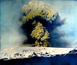
1875 March - Askja One of the largest ash eruptions in Icelandic history began on 28 March and lasted for about eight hours. Eruption from Víti and other craters. Heavy damage from ash fall in the middle of East Iceland and many farms were deserted. Many East Fjord people moved to the West as a result. Öskjuvatn was formed and it grew steadily. Eruptions occurred for several months. (Part of the North volcanic zone (NVZ))
1910 - Grímsvötn. Ashfall was observed in the east of the country from June to November. This eruption has been assigned by some to Thórðarhyrna which has geological interactions with Grímsvötn,[164][165] although not in official databases[166][167] It may also be linked to the Loki-Fögrufjöll eruption of the same year. (Part of the East volcanic zone (EVZ))
1910 Loki-Fögrufjöll The last confirmed eruption was in 1910 when tephra was erupted. (Part of the Bárðarbunga fissure system. 1910 was the last known eruption of Bárðarbunga before the 2014 eruptions.)[168][169] It may also be linked to the Grímsvötn eruption of the same year.(Part of the East volcanic zone (EVZ))
1930s - Gjálp An eruption took place in the 1930s. It had also caused a Jökulhlaup (literally "glacial run") a type of glacialoutburst flood), but at the time, science could not yet analyze the events. The eruption remained subglacial.[20] Might be the same as the following eruption north of Grímsvötn. (Part of the East volcanic zone (EVZ))
1947-48 - Hekla, eruption number 14 began on 29 March with an explosion. First eruption in Hekla in over 100 years. The plume reached a height of 30km (19mi) ash fall to the south over Fljótshlíð and Eyjafjöll. Heklugjá opened lengthwise, about 0.8km3 (0.19cumi) of lava flowed, mostly to the west and southwest from Axlargígur. One Icelandic geologist died while doing research at the eruption.[171](Part of the East volcanic zone (EVZ))
1961 - Askja. Lava eruption began on 26 October on a 300m-long (980ft) fissure and lasted until the end of November. (Part of the North volcanic zone (NVZ))
1961 - Trölladyngja. Reports of an eruption in 1961 at Trölladyngja are most likely attributed to nearby Askja Caldera, which erupted the same year.[90][172]
1963- 67 - Vestmannaeyjar: Surtsey rose from the sea on 14 November in an underwater eruption southwest of Geirfuglasker. Later, the islands Syrtlingur and Jólnir were formed but soon disappeared again.
1970 - Hekla, eruption number 15 began on 5 May in the southwestern part of Heklugjár and in Skjólkvíar north of the mountain. Considerable ash fall to NNV, all the way north to Húnavatnssýslur. In the mountain itself the activity stopped after a few days but in Skjólkvíar it erupted for about 2 months. (Part of the East volcanic zone (EVZ))
1973 - Eldfell, Westman Islands, VEI 3. A 1,600m-long (5,200ft) eruption fissure opens east of the town Vestamnnaeyar on the island Heimaey on 23 January. About a third of the town was buried under lava, over 400 properties were destroyed. The lava front was cooled by pumping seawater on it, it saved the important harbour entrance. A volcano formed and Heimaey expanded to the east.[173]
1980-81 - Hekla, eruption number 16 began on 17 August and lasted until the 20th. Ash spread to the north, lava flowed mostly to the west and north. The eruption resumed on 9 April of the following year and ended on 16 April. (Part of the East volcanic zone (EVZ))
? 1985 - Final ridge under Vatnajökull. Possible eruption. small earthquakes and sigg boilers in the glacier.
1986 Loki-Fögrufjöll Possible subglacial eruption - the last confirmed eruption was in 1910. (Part of the Bárðarbunga fissure system. See Loki-Fögrufjöll 1910 above).[169]
1991 - Hekla, eruption number 17 began on 17 January in the southern part of Heklugjár but soon subsided. One crater east of the mountain was active until 17 March. A considerable amount of lava flowed on the south side of the mountain, but there was little ash fall. (Part of the East volcanic zone (EVZ))
1991 Loki-Fögrufjöll Possible subglacial eruption - the last confirmed eruption was in 1910. (Part of the Bárðarbunga fissure system. See Loki-Fögrufjöll 1910 above).[169]
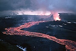
1996 - 1996 eruption of Gjálp (Gjálpargosið / Bárðarbunga). An eruption began on 30 September in a 4–5km (2.5–3.1mi) fissure under Vatnajökull between Bárðarbunga and Grímsvötn and lasted until 13 October. The seismic activity indicated a magma flow from Bárðarbunga. Melting water flowed to Grímsvötn and filled the subglacial lake to highest level ever recorded. The long-awaited jökulhlaup then submerged Skeiðarársandur on 5 November, damaging several bridges. (Part of the East volcanic zone (EVZ))
2010 - Eyjafjallajökull. The VEI 4 eruption began in Eyjafjallajökull on 14 April. It caused major disruption to air travel in Northwestern Europe and across the North Atlantic, not seen before. (Part of the East volcanic zone (EVZ))
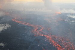
2014-15 Bárðarbunga. (main article - Bárðarbunga). In August 2014, a swarm of around 1,600 earthquakes in 48 hours, with magnitudes up to 4.5MW,[177][178] was followed on 23 August by the USGSAviation Color Codes being raised from orange to red, indicating an eruption in progress.[179] The following day, the aviation risk was lowered from red to orange and the statement that there was an eruption in progress was retracted.[180] However, later aerial observations of glacial depressions southeast of the volcano suggested that the now-retracted report of an eruption had been correct and that a short eruption did occur under the ice, but the lack of further melting indicated that this eruption had now ceased. Then, a new fissure eruption breached the surface between Bárðarbunga and Askja, in the Holuhraun lava field, in the early hours of 29 August.[181] This was followed by a second fissure eruption in the Holuhraun area, along the same volcanic fissure, which started shortly after 4 am on 31 August.[182]Part of the East volcanic zone (EVZ))
2022 - Fagradalsfjall. The eruption began in the valley Meradalir on 3 August on top of a lava flow from the previous year's eruption. (Part of the Reykjanes volcanic zone (RVZ))
- Sundhnúkur first eruption - began on 18 December 2023, around 22:00, at the Sundhnúkur crater chain and ended 3 days later on December 21.[184][185][186] See (Main article: December 2023 eruption)
- Sundhnúkur second eruption - began in the early hours of 14 January 2024 (around 7:57 UTC) and ended on 16 January. It resulted in damage by lava to the outskirts of Grindavík.[187][186][188][189] See (Main article: January 2024 eruption)
- Sundhnúkur third eruption - began on 8 February 2024 (around 6:07 UTC), about a kilometre north of Grindavík, in the same area as the December eruption.[186] See (Main article: February 2024 eruption)
- Sundhnúkur fourth eruption - began on 16 March 2024 (at 20:23 UTC) in the same area as the February eruption.[186] See (Main article: March 2024 eruption)
- Sundhnúkur fifth eruption - began on 29 May 2024 (at 12:45 UTC) and lasted until 22 June, being the largest in the Sundhnúkur series to date.[186] See (Main article: May 2024 eruption)
- Sundhnúkur sixth eruption - began on 22 August 2024 (at 21:25 UTC) and finished 6 September.[186] See (Main article: August 2024 eruption)
- Sundhnúkur seventh eruption - began on 20 November 2024 (at 23:14 UTC).[190] and lasted for 18 days, ending on 8 December.[191] See (Main article: November 2024 eruption)
- Sundhnúkur eighth eurption - began on 1 April 2025 (at 09:45 UTC)[192]
Volcanism in Iceland. The Volcanic zones and the dotted circle approximating to the hotspot.Topographic map showing the Iceland Plateau (light blue oval area) encircling Iceland in the Atlantic Ocean.
Iceland has several major volcanic zones surrounding the Iceland hotspot:
The East Volcanic Zone (EVZ), the central volcanoes Vonarskarð and Hágöngur, belong to the same volcanic system.[193] The southern propagating rift region of the EVZ with more tendency to explosive eruption characteristics is known as the Southern Iceland Volcanic Zone (SIVZ).[62]
The Kolbeinsey Ridge is a segment of the Mid-Atlantic Ridge located to the north of Iceland in the Arctic Ocean. It is bounded to the south by the Tjörnes Fracture Zone, which connects the submarine ridge to the on-shore Northern Volcanic Zone rifting center in eastern Iceland.[48] The volcanic islands Kolbeinsey and Grímsey lie along the Kolbeinsey Ridge.
North of Iceland, the Mid-Atlantic Ridge is called Kolbeinsey Ridge (KR) and is connected to the North Volcanic Zone via the Tjörnes Fracture Zone (TFZ).
The Reykjanes volcanic zone (RVZ or Reykjanes volcanic belt, RVB) contains multiple fissure vent orientated volcanic systems including one with a similar name. It is the continuation of the Reykjanes Ridge (RR) (the Mid-Atlantic Ridge south of Iceland and intersects to its north-east at Hengill with the WVZ and the South Iceland seismic zone (SISZ, also known as the Reykjanes fracture zone, RFZ).
The Snæfellsnes volcanic belt (SVB) is an intraplate volcanic belt, connected to the North American plate.[194]
It is proposed that the east–west line from the Grímsvötn volcano in the Mid-Iceland Belt (MIB) to the SVB shows the movement of the North American Plate over the Iceland hotspot.[196]
The South Iceland Seismic Zone (SISZ) is a fracture zone, which connects the East and West Volcanic Zones. It contains its own volcanic systems, smaller than those in the Mid-Iceland Belt. The SISZ is a set of major and active transform faults striking west-northwest in southwestern Iceland, being one of two large fracture zones, associated with such transform faults, striking about 75°N to 80°W, the other being the Tjörnes Fracture Zone.[85][86]
The Tjörnes Fracture Zone (TFZ) connects the North Volcanic Zone to the Kolbeinsey Ridge (KR), which is part of the Mid-Atlantic Ridge. It contains its own volcanic systems, which are smaller than those in the Mid-Iceland Belt.
It is one of two major and active transform faults zones striking west-northwest in northern and southern Iceland.[85] The Tjörnes and Reykjanes Fracture Zones are found striking about 75°N to 80°W.[86]
Grímsvötn, including the Skaftá eruption of 1783, is probably the most eruptive volcano system. The Lakagígar lava field alone is estimated to have produced about 15 cubic kilometres (3.6cumi) of lava. Grímsvötn has probably had more than 30 eruptions in the last 400 years, and produced around 55 cubic kilometres (13cumi) over the last 10,000 years.[1](Part of the East volcanic zone (EVZ)) See Grímsvötn index above.
Katla eruptivity
Katla has erupted 17 times in historical times, and Eldgjá seems to be part of the same system. The total volume of volcanic eruptions from Katla over the last 10,000 years is very similar to Grímsvötn.[1](Part of the East volcanic zone (EVZ)). See Katla index above.
Hekla eruptivity
Hekla has erupted at least 17 times in historical times, with total volume about 7 cubic kilometres (1.7cumi), but around 42 cubic kilometres (10cumi) since the last ice age.[1](Part of the East volcanic zone (EVZ)). See Hekla index above.
↑ Íslandshandbókin. Náttúra, saga og sérkenni. Reykjavík 1989, p.53
↑ See eg. maps herein: Ermias Yohannes Berhane: Geochemical interpretation of thermal water and gas samples from Krýsuvík, Iceland and Alid, Eritrea. The United Nations University. Report No. 18, 2004.
↑ "Svarfdæla saga". www.snerpa.is. Archived from the original on 20 November 2020. Retrieved 28 August 2020.
↑ Sæmundsson, Kristján; Hjartarson, Árni (1994). "Geology and erosion of Kolbeinsey". In Gísli Viggóson (ed.). Proceedings of the Hornafjörlur International Costal Symposium. Orkustofnun (National Energy Authority of Iceland). pp.443–451. Archived from the original on 9 January 2006. Retrieved 11 April 2008.
↑ "Nýjahraun". Iceland Road Guide. Retrieved 13 May 2022.
↑ Jaggar, TAKE (1947). Origin and Development of Craters. Origin and Development of Craters. p.376. ISBN9780813710211.{{cite book}}: ISBN / Date incompatibility (help)
↑ Thorvaldur Thordarson and Ármann Höskuldsson: Postglacial volcanism in Iceland, Jökull no. 58, 2008. Retrieved 2 August 2020. (System no. 2 on the maps and tables)
1 2 Gunnar Karlsson (2000), Iceland's 1100 Years, p. 181
↑ Brayshay and Grattan, 1999; Demarée and Ogilvie, 2001
1 2 Sigurður Steinþórsson. "Í hvaða gosi myndaðist hraunið hjá Landmannalaugum og hvaða ár?". The Icelandic Web of Science July 4. 2008. Retrieved 21 August 2014. (in Icelandic)
1 2 Kahl, M; Bali, E.; Guðfinnsson, G.H.; Neave, D.A.; Ubide, T.; van der Meer, Q.H.A.; Matthews, S. (2021). "Conditions and Dynamics of Magma Storage in the Snæfellsnes Volcanic Zone, Western Iceland: Insights from the Búðahraun and Berserkjahraun Eruptions". Journal of Petrology. 62 (9) egab054. doi:10.1093/petrology/egab054.
↑ "Katla Volcano". Institute of Earth Sciences. University of Iceland. Archived from the original on 9 November 2009. Retrieved 12 March 2010.
↑ Mangerud, J., Lie, S.V., Furned, H., Kristiansen, I.L., Lømo, L. (1984) A Younger Dryas Ash Bed in Western Norway, and Its Possible Correlations with Tephra in Cores from the Norwegian Sea and the North Atlantic. Quaternary Research 21 85–104
↑ Árni Hjartarson 1988: „Þjórsárhraunið mikla - stærsta nútímahraun jarðar". Náttúrufræðingurinn 58: 1-16.
↑ Árni Hjartarson 1994: „Environmental changes in Iceland following the Great Þjórsá Lava Eruption 7800 14C years BP". In: J. Stötter og F. Wilhelm (ed.) Environmental Change in Iceland (Munchen): 147-155.
↑ Árni Hjartarson 1988: „Þjórsárhraunið mikla – stærsta nútímahraun jarðar". Náttúrufræðingurinn 58: 1–16.
↑ Guðrún Sverrisdóttir; Níels Óskarsson; Árný E. Sveinbjörnsdóttir; Rósa Ólafsdóttir. "The Selsund Pumice and the old Hekla crater"(PDF). Institute of earth sciences, Reykjavik. Archived from the original(PDF) on 19 December 2008. Retrieved 7 July 2008.
↑ Elsa G. Vilmundardóttir og Árni Hjartarson 1985: Vikurhlaup í Heklugosum. Náttúrufræðingurinn 54, 17-30.
↑ Yurco, Frank J. (1999). "End of the Late Bronze Age and Other Crisis Periods: A Volcanic Cause". In Teeter, Emily; Larson John (eds.). Gold of Praise: Studies on Ancient Egypt in Honor of Edward F. Wente. Studies in Ancient Oriental Civilization. Vol.58. Chicago, IL: Oriental Institute of the Univ. of Chicago. pp.456–458. ISBN1-885923-09-0.
↑ Reynir Ingibjartsson: 25 Gönguleiðir á Reykjanesskaga. Náttúrann við Bæjarveggin. Reykjavík, p.112 - 117
↑ Íslandshandbókin. Náttúra, saga og sérkenni. Reykjavík 1989, p.45
↑ Sæmundsson, Kristján (2019). "Catalogue of Icelandic Volcanoes - Hengill". Icelandic Meteorological Office, Institute of Earth Sciences at the University of Iceland, Civil Protection Department of the National Commissioner of the Iceland Police. Retrieved 3 July 2024.:Short description
↑ Rosi, Mauro; Luip, Luca; Papale, Paolo; Stoppato, Marco (2003). Volcanoes (A Firefly Guide). Firefly Books. pp.130, 131. ISBN978-1-55297-683-8.
↑ Abbott, D. H.; Biscaye, P.; Cole-Dai, J.; Breger, D. (December 2008). "Magnetite and Silicate Spherules from the GISP2 Core at the 536 A.D. Horizon". AGU Fall Meeting Abstracts. American Geophysical Union, Fall Meeting 2008. Vol.41. pp.41B–1454. Bibcode:2008AGUFMPP41B1454A. Abstract #PP41B-1454.
↑ Jaggar, TAKE (1947). Origin and Development of Craters. Origin and Development of Craters. p.376. ISBN9780813710211.{{cite book}}: ISBN / Date incompatibility (help)
↑ T. Gudmundsson; Thórdís Högnadóttir (January 2007). "Volcanic systems and calderas in the Vatnajökull region, central Iceland: Constraints on crustal structure from gravity data". Journal of Geodynamics. 43 (1): 153–169. Bibcode:2007JGeo...43..153G. doi:10.1016/j.jog.2006.09.015.
1 2 T. Thordarson; G. Larsen (January 2007). "Volcanism in Iceland in historical time: volcano types, eruption styles and eruptive history". Journal of Geodynamics. 43 (1): 118–152. Bibcode:2007JGeo...43..118T. doi:10.1016/j.jog.2006.09.005.
↑ H. Jóhannesson; K. Sæmundsson (1998). Geologic Map of Iceland, 1:500,000. Bedrock Geology. Reykjavík: Icelandic Institute of Natural History and Iceland Geodetic Survey.
This page is based on this Wikipedia article Text is available under the CC BY-SA 4.0 license; additional terms may apply. Images, videos and audio are available under their respective licenses.