
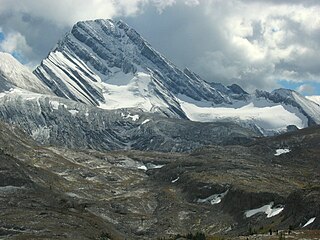
Mount Columbia is a mountain located in the Winston Churchill Range of the Rocky Mountains. It is the highest point in Alberta, Canada, and is second only to Mount Robson for height and topographical prominence in the Canadian Rockies. It is located on the border between Alberta and British Columbia on the northern edge of the Columbia Icefield. Its highest point, however, lies within Jasper National Park in Alberta.

Mount Lyell is a mountain on the Alberta–British Columbia border in western Canada. Comprising five distinct summits, Mount Lyell reaches a height of 3,498 m (11,476 ft). The mountain was named by James Hector in 1858 in recognition of Scottish geologist Sir Charles Lyell.

Mount Balfour is a mountain located on the Continental Divide, part of the border between British Columbia and Alberta, in the Waputik Range in the Park Ranges of the Canadian Rockies. It is the 71st highest peak in Alberta and the 113th highest in British Columbia; it is also the 52nd most prominent in Alberta.

Mount Robertson is a mountain in the Canadian Rockies, standing astride the British Columbia-Alberta boundary between Palliser Pass and North Kananaskis Pass. The British Columbia side of the pass is in Mount Assiniboine Provincial Park. The mountain is named for Sir William Robertson (1860–1933), 1st Baronet, Chief of the Imperial General Staff from 1916 to 1918 during the First World War.
Apex Mountain is located on the Canadian provincial boundary between Alberta and British Columbia. It was named in 1927 and is located in the centre of the Clemenceau Icefield.
Mount Lambe is a 3,182-metre (10,440-foot) mountain summit located in the Canadian Rockies on the border of Alberta and British Columbia. It was named in 1918 after Lawrence Morris Lambe, a Canadian geologist, palaeontologist, and ecologist from the Geological Survey of Canada.

Mount Olive is located N of the head of the Yoho River on the Continental Divide, on the Alberta-British Columbia border, in both Banff National Park and Yoho National Park. It lies on the eastern edge of the Wapta Icefield, and is part of the Waputik Mountains. It was named in 1898 by H.B. Dixon after his wife Dixon, Olive.

Mount Daly is located on the border of Alberta and British Columbia. It was named in 1898 by Charles E. Fay after Charles P. Daly, a geographer. Mount Niles is located two km southwest of Daly.

Mount Bosworth is located in the Canadian Rockies on the border of Alberta and British Columbia. The mountain is situated immediately northwest of Kicking Horse Pass and straddles the shared border of Banff National Park with Yoho National Park. It was named in 1903 after George Morris Bosworth, an executive and long-time employee of the Canadian Pacific Railway.

Mount Bowlen is located on the border of Alberta and British Columbia and forms part of the Valley of the Ten Peaks. It was named in 1953 after John J. Bowlen, a native of Prince Edward Island, successful Alberta rancher, honorary chief of the Blackfoot, and a Lieutenant Governor of Alberta. Its former name was "Yamnee", which translates to the number 3 in the local Nakoda (Stoney) language.

Mount Fay is a mountain located on the border of Alberta and British Columbia on the Continental Divide in the Canadian Rockies. The mountain forms part of the backdrop to Moraine Lake in the Valley of the Ten Peaks of Banff National Park. It was named in 1902 by Charles E. Fay, an early explorer of the Canadian Rockies. He was a member of the party who attempted Mount Lefroy in 1896 when the first mountaineer to be killed in the Canadian Rockies occurred.

Aye Mountain is located on the Canadian provincial boundary between Alberta and British Columbia on the Continental Divide. It was named in 1913 by the Interprovincial Boundary Survey.
Mount Sir Douglas is located on the border of Alberta and British Columbia on the Continental Divide, at the northern end of Height of the Rockies Provincial Park and east of Invermere. It is Alberta's 18th highest peak, and 28th prominence mountain as well as British Columbia's 28th highest peak. It was named in 1916 by interprovincial boundary surveyors after Field Marshal Sir Douglas Haig.

Mount Beatty is a mountain located on the border of Alberta and British Columbia on the Continental Divide. It was named in 1924 after David Beatty, a British naval officer of Irish ancestry who commanded ships in the First World War.

Mount Foch is a 3,194-metre (10,479-foot) mountain summit located on the border of Alberta and British Columbia on the Continental Divide. It was named in 1918 after Marshal Ferdinand Foch.

Warrior Mountain is located north of Mount Joffre in Height of the Rockies Provincial Park and straddles the Continental Divide marking the Alberta-British Columbia border. It was named in 1917 after HMS Warrior. The first ascent of the mountain was made in 1930 by Kate (Katie) Gardiner and Walter Feuz. The duo also made the first ascents of nearby Mount Sarrail and Mount Lyautey that same year.

Mount Fox is a 2,973-metre (9,754-foot) mountain on the shared border between Alberta and British Columbia, Canada. It is situated on the Continental Divide south of the Kananaskis Lakes area of the Canadian Rockies. It was named in 1859 by John Palliser after Sir Charles Fox (1810-1874), a member of the Royal Geographical Society.

Mount Odlum is located on the border of Alberta and British Columbia on the Continental Divide. It was named in 1917 after Victor Wentworth Odlum, Brigadier-General in the Canadian army during World War I. After the war, he entered politics from 1924–1947.

Baril Peak is located on the border of Alberta and British Columbia on the Continental Divide. It was named in 1918 after Conrad M.L. Baril, a Dominion surveyor killed in World War I.
Mount Huber is a 3,348-metre (10,984-foot) summit located two kilometres east of Lake O'Hara in the Bow Range of Yoho National Park, in the Canadian Rockies of British Columbia, Canada. The nearest higher neighbor is Mount Victoria, 1.0 km (0.62 mi) to the north-northeast on the Continental Divide. Mount Huber is a secondary summit of Mount Victoria.


