Mount Head (Alberta)

Last updated
Mount Head
TSL 2752 (14971256307).jpg
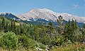
West aspect at sunset
Highest point
Elevation 2,782 m (9,127 ft) [1]
Prominence 403 m (1,322 ft) [2]
Parent peak Lineham Ridge [2]
Isolation 10.94 km (6.80 mi) [2]
Listing Mountains of Alberta
Coordinates 50°26′25″N114°39′00″W / 50.44028°N 114.65000°W / 50.44028; -114.65000 Coordinates: 50°26′25″N114°39′00″W / 50.44028°N 114.65000°W / 50.44028; -114.65000 [3]
Naming
Etymology Edmund Walker Head
Geography
Canada Alberta relief location map - transverse mercator proj.svg
Red triangle with thick white border.svg
Mount Head
Location of Mount Head in Alberta
Canada relief map 2.svg
Red triangle with thick white border.svg
Mount Head
Mount Head (Canada)
Country Canada
Province Alberta
Protected area Don Getty Wildland Provincial Park
Parent range Highwood Range
Canadian Rockies
Topo map NTS 82J7 Mount Head [3]
Geology
Mountain type Fault block
Type of rock Sedimentary rock
Climbing
First ascent 1934 by Raymond M. Patterson
Easiest route Scrambling [4]

Mount Head is a 2,782-metre (9,127-foot) mountain summit located in Alberta, Canada.

Contents

Description

Mount Head is situated 83 km (52 mi) southwest of Calgary near the southern end of the Highwood Range which is a subrange of the Canadian Rockies. [5] The peak is set 14 km (8.7 mi) east of the Continental Divide, in Don Getty Wildland Provincial Park. Precipitation runoff from the mountain drains into tributaries of the Highwood River. Topographic relief is significant as the summit rises 1,200 meters (3,937 ft) above the Highwood Valley in 5 km (3.1 mi). The mountain can be seen from Highway 40 and Highway 541. [6]

History

The mountain was named in 1859 by John Palliser to honor Edmund Walker Head (1805–1868), the Governor General of the Province of Canada who had provided support for the Palliser expedition. [1] The mountain's toponym was officially adopted March 31, 1924, by the Geographical Names Board of Canada. [3]

The first ascent of the summit was made in 1934 by Raymond M. Patterson. [6] The peak immediately northwest of Mt. Head on the opposite side of Head Creek is officially named "Patterson's Peak" in his honor. [7]

Geology

Mount Head was created during the Lewis Overthrust. The peak is underlain by folded and thrust-faulted sedimentary rock laid down during the Mesozoic and Paleozoic eras. Formed in shallow seas, this sedimentary rock was pushed east and over the top of younger rock during the Laramide orogeny. [8] The Mount Head Formation formed during the Viséan age.

Climate

Based on the Köppen climate classification, Mount Head is located in a subarctic climate zone with cold, snowy winters, and mild summers. [9] Winter temperatures can drop below −20 °C with wind chill factors below −30 °C. The months June through September offer the most favorable weather to climb or view Mount Head.

See also

Related Research Articles

<span class="mw-page-title-main">Mount Ball</span>

Mount Ball is a mountain located on the Continental Divide, on the borders of Banff and Kootenay national parks in Western Canada. Mt. Ball is the highest peak of the Ball Range in the Canadian Rockies.

<span class="mw-page-title-main">Mount Saskatchewan (Alberta)</span> Mountain in Banff National Park, Alberta, Canada

Mount Saskatchewan is a mountain located in the North Saskatchewan River valley of Banff National Park, in the Canadian Rockies of Alberta, Canada.

<span class="mw-page-title-main">Mount Glasgow</span>

Mount Glasgow is a prominent 2,935-metre (9,629 ft) pyramid-shaped summit located between the Elbow River valley and Little Elbow River valley of Kananaskis Country in the Canadian Rockies of Alberta, Canada. The peak is visible from Calgary, weather permitting. Mount Glasgow's nearest higher peak is Mount Cornwall, 2.0 km (1.2 mi) to the southwest.

<span class="mw-page-title-main">Mount Nestor (Alberta)</span> Mountain in Alberta, Canada

Mount Nestor is a 2,970-metre (9,740 ft) mountain summit located in Kananaskis Country in the Canadian Rockies of Alberta, Canada. It is named after HMS Nestor, a destroyer sunk in the Battle of Jutland during World War I. Mount Nestor is situated at the south end of the Goat Range along the west shore of Spray Lakes Reservoir. Nestor's east flank is within Spray Valley Provincial Park, while the west aspect is within Banff National Park, with the boundary line between the two parks running roughly north-to-south over its summit. The nearest higher peak is Old Goat Mountain, 2.0 km (1.2 mi) to the north. Mount Nestor can be seen from Alberta Highway 742, the Smith-Dorrien/Spray Trail.

<span class="mw-page-title-main">Mount Lougheed</span>

Mount Lougheed is a 3,107-metre (10,194-foot) triple-peak mountain located between Spray Lakes Reservoir and the Wind Valley of Kananaskis Country in the Canadian Rockies of Alberta, Canada. The highest summit is known as Peak 2. Peak 1 to the northwest is 3,080 metres. Peak 3 to the southeast is 3,010 metres. The nearest higher peak is Wind Mountain, 2.0 km (1.2 mi) to the southeast. Mount Lougheed is a conspicuous landmark that can be seen from Highway 1, the Trans-Canada Highway at Dead Man's Flats which is east of Canmore.

<span class="mw-page-title-main">Mount Weed</span> Mountain in Banff NP, Alberta, Canada

Mount Weed is a 3,080-metre (10,100-foot) mountain summit located in the Mistaya River valley of Banff National Park, in the Canadian Rockies of Alberta, Canada. Mount Weed is situated at the confluence of Silverhorn Creek and Mistaya River, 3.5 kilometres southwest of Mount Noyes, 4.5 km east of Mistaya Lake, and 14 km north of Bow Lake. Its nearest higher peak is Mount Patterson, 5.82 km (3.62 mi) to the southwest. Patterson stands directly across the Mistaya River valley from Weed, and both are prominent features seen from the Icefields Parkway.

<span class="mw-page-title-main">Gap Mountain (Alberta)</span> Mountain in Alberta, Canada

Gap Mountain is a 2,675-metre (8,776-foot) mountain summit located at the southern end of the Opal Range in the Canadian Rockies of Alberta, Canada. The nearest higher neighbor is Elpoca Mountain, 2.0 km (1.2 mi) to the east. Gap Mountain is situated 5.0 km south of Mount Wintour, within Peter Lougheed Provincial Park. Gap Mountain is a conspicuous peak seen from Alberta Highway 40 at Highwood Pass. It is a popular climbing destination because it offers interesting, exposed scrambling on its eastern flanks with excellent summit views of Kananaskis Country.

<span class="mw-page-title-main">Mount Shark</span> Mountain in Alberta, Canada

Mount Shark is a 2,786-metre (9,140-foot) mountain summit located in the Spray Valley of Kananaskis Country at the northern tip of the Spray Mountains range. It is situated on the southern boundary of Banff National Park in the Canadian Rockies of Alberta, Canada. Mount Shark in not visible from any road in Banff Park, however, it can be seen from Alberta Highway 742, also known as the Smith-Dorrien/Spray Trail. Mount Shark's nearest higher peak is Mount Smuts, 3.0 km (1.9 mi) to the southeast.

<span class="mw-page-title-main">Commonwealth Peak</span>

Commonwealth Peak is a 2,775-metre (9,104-foot) mountain summit in the Spray Mountains, a sub-range of the Canadian Rockies in Alberta, Canada. The mountain is situated in Peter Lougheed Provincial Park. Its nearest higher peak is Mount Birdwood, 1.0 km (0.62 mi) to the west. Both can be seen from Alberta Highway 742, also known as Smith-Dorrien/Spray Trail in Kananaskis Country.

<span class="mw-page-title-main">Mount Tekarra</span>

Mount Tekarra is a 2,694 metres mountain summit located in the Athabasca River valley of Jasper National Park, in the Canadian Rockies of Alberta, Canada. It is situated at the northwest end of the Maligne Range and is visible from Jasper and the Icefields Parkway. The nearest higher neighbor is The Watchtower, 7.0 km (4.3 mi) to the east.

<span class="mw-page-title-main">Mount Andromache</span>

Mount Andromache is a 3,033-metre (9,951-foot) mountain summit located in the Bow River valley of Banff National Park, in the Canadian Rockies of Alberta, Canada. The nearest higher neighbor is Mount Hector, 4.00 km (2.49 mi) to the south. Mount Andromache can be seen from the Icefields Parkway as the road traverses the western base of the peak. Topographic relief is significant as the summit rises 1,180 meters (3,870 ft) above the parkway in 1.5 km (0.93 mi). The Molar Glacier is situated on the northeast aspect of the mountain. Precipitation runoff from Mount Andromache drains into tributaries of the Bow River.

<span class="mw-page-title-main">Mount Peskett</span>

Mount Peskett is a 3,124-metre (10,249-foot) mountain summit located in the North Saskatchewan River valley of Alberta, Canada. Mount Peskett is situated in the Canadian Rockies on the northern boundary the Siffleur Wilderness Area. Its nearest higher peaks are Mount Loudon, 3.7 km (2.3 mi) to the south, and Siffleur Mountain 3.7 km to the southeast. Mount Peskett can be seen from Highway 11, the David Thompson Highway. Precipitation runoff from the mountain flows north via Loudon Creek and Spreading Creek which are both tributaries of the North Saskatchewan River.

<span class="mw-page-title-main">Mount Noyes</span> Mountain in Banff NP, Alberta, Canada

Mount Noyes is a 3,080-metre (10,100-foot) mountain summit located in the Mistaya River valley of Banff National Park, in the Canadian Rockies of Alberta, Canada. Mount Noyes is situated at the confluence of Silverhorn Creek and Mistaya River, 3.5 km northwest of Mount Weed, and 9.2 km east of Howse Peak. Its nearest higher peak is Mount Patterson, 8.55 km (5.31 mi) to the south. Topographic relief is significant as it rises over 1,380 metres above the Icefields Parkway in two km.

<span class="mw-page-title-main">Mount Tecumseh (Alberta)</span>

Mount Tecumseh is a 2,547-metre-high (8,356 ft) mountain summit located in the Canadian Rockies of Alberta, Canada.

<span class="mw-page-title-main">Seven Sisters Mountain</span>

Seven Sisters Mountain is a 2,591-metre-high (8,501 ft) mountain summit located in the Canadian Rockies of Alberta, Canada.

<span class="mw-page-title-main">Mount Parrish</span>

Mount Parrish is a 2,530-metre (8,301-foot) mountain summit located in Alberta, Canada.

<span class="mw-page-title-main">Holy Cross Mountain</span> Mountain in Alberta, Canada

Holy Cross Mountain is a 2,650-metre (8,694-foot) mountain summit located in Alberta, Canada.

<span class="mw-page-title-main">Mount Bell (Alberta)</span> Mountain in Alberta, Canada

Mount Bell is a 2,910-metre (9,550 ft) summit in Alberta, Canada.

<span class="mw-page-title-main">Mount Howard (Alberta)</span>

Mount Howard is a 2,777-metre (9,111-foot) mountain summit located 68 km (42 mi) west-southwest of Calgary in Kananaskis Country of Alberta, Canada. Mount Howard is the fourth-highest peak in the Fisher Range which is a subrange of the Canadian Rockies. The nearest higher neighbor is Fisher Peak, 5.03 km (3.13 mi) to the southwest. Precipitation runoff from the mountain drains into Nihahi Creek and Canyon Creek which are tributaries of the Elbow River. Topographic relief is modest as the summit rises 777 metres (2,549 ft) above Canyon Creek in approximately 2 km (1.2 mi).

<span class="mw-page-title-main">Pyriform Mountain</span>

Pyriform Mountain is a 2,739-metre (8,986-foot) mountain summit located 74 km (46 mi) southwest of Calgary in Kananaskis Country of Alberta, Canada. Pyriform Mountain is the third-highest officially named peak in the Highwood Range which is a subrange of the Canadian Rockies. Precipitation runoff from the mountain's west slope drains into headwaters of Junction Creek which is a tributary of the Sheep River; and the east slope drains to Trap Creek which is a tributary of the Highwood River. Topographic relief is modest as the summit rises approximately 740 metres (2,428 ft) above Junction Creek in 2 km (1.2 mi).

References

  1. 1 2 Glen W. Boles, William Lowell Putnam, Roger W. Laurilla (2006), Canadian Mountain Place Names: The Rockies and Columbia Mountains, Rocky Mountain Books, ISBN   9781894765794, p. 120
  2. 1 2 3 "Mount Head, Peakvisor.com" . Retrieved November 25, 2022.
  3. 1 2 3 "Mount Head". Geographical Names Data Base . Natural Resources Canada . Retrieved 2022-11-25.
  4. Andrew Nugara (2014), More Scrambles in the Canadian Rockies, Rocky Mountain Books, ISBN   9781771600163, p. 204
  5. Dave Birrell, Ron Ellis (2000), Calgary's Mountain Panorama, Rocky Mountain Books, ISBN   9780921102120, p. 20
  6. 1 2 "Mount Head". PeakFinder.com. Retrieved 2022-11-25.
  7. David Finch (2011), R.M. Patterson: A Life of Great Adventure, Touchwood Editions, ISBN   9781926971292]
  8. Gadd, Ben (2008). Geology of the Rocky Mountains and Columbias.
  9. Peel, M. C.; Finlayson, B. L.; McMahon, T. A. (2007). "Updated world map of the Köppen−Geiger climate classification". Hydrol. Earth Syst. Sci. 11: 1633–1644. ISSN   1027-5606.