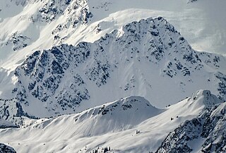
The Monarch is a 2,895-metre (9,498-foot) mountain summit located in the Ball Range of the Canadian Rockies in British Columbia, Canada. The Monarch is situated on the boundary between Kootenay National Park and Mount Assiniboine Provincial Park, four kilometres to the west side of the Continental Divide. Although not visible from roads, The Monarch is a prominent feature seen from the slopes above Sunshine Village ski resort. Its nearest higher peak is Mount Bourgeau, 10.35 km (6.43 mi) to the north-northeast.

Mount Fisher, also known locally as Fisher Peak, is a 2,843-metre (9,327-foot) mountain summit located in the Hughes Range of the Canadian Rockies in British Columbia, Canada. Situated east of historic Fort Steele and the Rocky Mountain Trench, this prominent peak is visible from the Crowsnest Highway and Cranbrook. Its nearest higher peak is Mount Morro, 23.0 km (14.3 mi) to the north. The Steeples are located 10.0 km (6.2 mi) to the south.

The Steeples is a 2,843-metre (9,327-foot) elevation mountain ridge located at the southern end of the Hughes Range in the Canadian Rockies of British Columbia, Canada. Situated immediately east of Norbury Lake Provincial Park and the Rocky Mountain Trench, this prominent five kilometres in length ridge is visible from the Crowsnest Highway and Cranbrook. The nearest higher peak is Mount Fisher, 10.0 km (6.2 mi) to the north-northwest.

Floe Peak is a 3,006-metre (9,862 ft) mountain summit located on the western border of Kootenay National Park, in the Canadian Rockies of British Columbia, Canada. The name for this mountain has not been officially adopted yet. Its nearest higher peak is Foster Peak, 3.0 km (1.9 mi) to the northwest, and both are part of the Vermilion Range. The mountain is part of what is known as the Rockwall in the Vermilion Range, and is named for Floe Lake which is situated below the enormous northern cliffs of the peak. Floe Lake, one of the beauty spots of Kootenay Park, is accessible via the Floe Lake Trail.

Foster Peak is a 3,204-metre (10,512-foot) mountain summit located on the western border of Kootenay National Park. It is the highest point in the Vermilion Range, a sub-range of the Canadian Rockies of British Columbia, Canada. Its nearest higher peak is Mount Ball, 14.96 km (9.30 mi) to the northeast. The mountain is part of what is known as The Rockwall. Floe Lake, southeast of the peak, is one of the beauty spots of Kootenay National Park. The area is accessible via the Floe Lake Trail and Rockwall Trail. The Rockwall Trail is a scenic 55 kilometre traverse of alpine passes, subalpine meadows, hanging glaciers, and limestone cliffs, in some places in excess of 900 metres above the trail.

Mount Gray is a 2,886-metre (9,469-foot) mountain summit located on the western border of Kootenay National Park in the Vermilion Range, which is a sub-range of the Canadian Rockies in British Columbia, Canada. Its nearest higher peak is Tumbling Peak, 3.1 km (1.9 mi) to the southeast. The mountain is part of what is known as the Rockwall which is an escarpment of the Vermilion Range. The Rockwall Trail is a scenic 55 kilometre traverse of alpine passes, subalpine meadows, hanging glaciers, and limestone cliffs, in some places in excess of 900 m (2,953 ft) above the trail.

Gladsheim Peak is a prominent 2,830-metre (9,280-foot) mountain summit located in the Valhalla Ranges of the Selkirk Mountains in British Columbia, Canada. Gladsheim is the highest point in the Valhalla Ranges. It is situated in the southern part of Valhalla Provincial Park, 2.7 km (1.7 mi) northeast of Gimli Peak, and 12 km (7.5 mi) west of Slocan and Slocan Lake. The name "Valhalla Mountains" first appeared in George Mercer Dawson's Geological Survey of Canada map published in 1890. Dawson applied names derived from Scandinavian mythology to several of the mountain ranges and peaks in Southern Kootenay. Gladsheim is the magnificent meeting hall containing thirteen council seats where, according to Norse mythology, Odin presided over all the realms. In keeping with the Valhalla theme, this peak's name was submitted in 1900 by R. W. Brock to the Geological Survey of Canada for consideration, and it was officially adopted March 31, 1924, by the Geographical Names Board of Canada.

Limestone Peak is a 2,878-metre (9,442-foot) mountain summit located in British Columbia, Canada.

Mount Shanks is a 2,838-metre (9,311-foot) mountain summit located in British Columbia, Canada.

Octopus Mountain is a 2,932-metre (9,619-foot) mountain summit located in Mount Assiniboine Provincial Park of British Columbia, Canada.

Mount Battisti is a 3,155-metre (10,351-foot) mountain summit in British Columbia, Canada.

Mount Sir Richard is a 2,681-metre (8,796-foot) glaciated summit in British Columbia, Canada.

Outlier Peak is a 2,422-metre (7,946-foot) mountain summit in British Columbia, Canada.

Nivalis Mountain is a 2,659-metre (8,724-foot) mountain summit in British Columbia, Canada.

Mount Neal is a 2,552-metre (8,373-foot) glaciated summit in British Columbia, Canada.

Carcajou Peak is a 2,239-metre (7,346-foot) mountain summit in British Columbia, Canada.

Mount Roberts is a 1,991-metre (6,532-foot) mountain summit in British Columbia, Canada.

Mount Wilkie is a 2,699-metre (8,855-foot) summit in British Columbia, Canada.

Mount Pitt is a 2,487-metre (8,159-foot) summit in British Columbia, Canada.

Mount Kindersley is a 2,697-metre (8,848-foot) mountain in British Columbia, Canada.


