Aoraki / Mount Cook is the highest mountain in New Zealand. Its height, as of 2014, is listed as 3,724 metres. It sits in the Southern Alps, the mountain range that runs the length of the South Island. A popular tourist destination, it is also a favourite challenge for mountain climbers. Aoraki / Mount Cook consists of three summits: from south to north, the Low Peak, the Middle Peak and the High Peak. The summits lie slightly south and east of the main divide of the Southern Alps, with the Tasman Glacier to the east and the Hooker Glacier to the southwest. Mount Cook is ranked 10th in the world by topographic isolation.
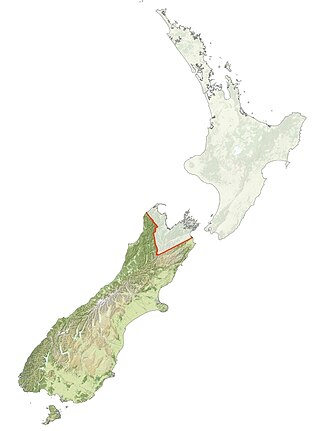
Ngāi Tahu, or Kāi Tahu, is the principal Māori iwi (tribe) of the South Island. Its takiwā is the largest in New Zealand, and extends from the White Bluffs / Te Parinui o Whiti, Mount Mahanga and Kahurangi Point in the north to Stewart Island / Rakiura in the south. The takiwā comprises 18 rūnanga corresponding to traditional settlements. According to the 2018 census an estimated 74,082 people affiliated with the Kāi Tahu iwi.

Mount Anglem / Hananui is the highest point on New Zealand's Stewart Island / Rakiura. It is located 20 kilometres (12 mi) northwest of Oban, close to the island's north coast, and rises to an elevation of 980 metres (3,215 ft) above sea level. Following the passage of the Ngāi Tahu Claims Settlement Act 1998, the name of the peak was officially altered to Mount Anglem / Hananui.

South Cape / Whiore is a cape marking the southernmost point of Stewart Island / Rakiura, and by extension the main New Zealand archipelago. It is one of the four Cardinal Capes of New Zealand identified by Captain James Cook on his first voyage, along with North Cape, Cape East and West Cape. Cook originally named the place "Cape South". At the time, Cook incorrectly charted the island as a peninsula attached to the South Island of New Zealand, with a narrow isthmus in place of Foveaux Strait. South Cape is also one of the world's five Great Capes, along with capes in South America, Africa, and Australia.
Claims and settlements under the Treaty of Waitangi have been a significant feature of New Zealand politics since the Treaty of Waitangi Act 1975 and the Waitangi Tribunal that was established by that act to hear claims. Successive governments have increasingly provided formal legal and political opportunity for Māori to seek redress for what are seen as breaches by the Crown of guarantees set out in the Treaty of Waitangi. While it has resulted in putting to rest a number of significant longstanding grievances, the process has been subject to criticisms including those who believe that the redress is insufficient to compensate for Māori losses. The settlements are typically seen as part of a broader Māori Renaissance.

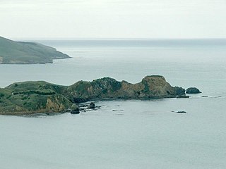
The Ōnawe Peninsula is a volcanic plug inside Akaroa Harbour, on Banks Peninsula in Canterbury, New Zealand. It is the site of a former pā. It is part of the Banks Peninsula Volcano.

The Jacobs River or Makawhio River is located some 30 km (19 mi) south of Fox Glacier in South Westland, New Zealand. From its headwaters near Fettes Peak below the Hooker Range it flows in a westerly direction to enter the Tasman Sea near Hunts Beach. Its tributaries include Jumbo Creek and Pavo Creek. Just upstream from the bridge is Borat Flat.
The Otago region of New Zealand is one of the more isolated places of the inhabited earth. Its high latitude, elevation and distance from larger foreign and domestic population centres have defined Otago at each stage of its history.

The Arahura River, for a time called the Brunner River after the explorer Thomas Brunner, is a river located on the West Coast of the South Island of New Zealand. In 1846 Brunner and Heaphy sketched and described a Māori settlement they called Araura [sic] (Arahura).
The New River / Kaimata is a river in the West Coast region of the South Island of New Zealand. It rises in the hills to the west of Lake Brunner and flows down the north edge of the floodplain of the Taramakau River then turns north for about 2 kilometres (1.2 mi) behind coastal dunes before meeting the Tasman Sea. There was much gold dredging activity around the river.

The Cam River / Ruataniwha is a small river in Canterbury in the South Island of New Zealand. It is a tributary of the Kaiapoi River, itself a tributary of the Waimakariri River.
Mount Grey is a 934-metre (3,065 ft) mountain 15 kilometres west of Amberley in New Zealand. It is named after Sir George Grey who was governor of New Zealand when English surveyors climbed it in 1849. In Te Reo Māori, the mountain is called Maukatere, 'floating mountain', from where the spirits of the dead leave on the long journey to Cape Reinga.

The Ashburton River / Hakatere is a river in the Canterbury region of New Zealand, flowing across Mid Canterbury from the Southern Alps to the Pacific Ocean. The official name of the river was amended to become a dual name by the Ngāi Tahu Claims Settlement Act 1998. It has been identified as an Important Bird Area by BirdLife International because it supports breeding colonies of the endangered black-billed gull.

Mount Herbert / Te Ahu Pātiki is, at 919 metres (3,015 ft), the highest peak on Banks Peninsula, New Zealand. It is south of Lyttelton Harbour with the township of Diamond Harbour at its northern foot.

The Ngāi Tahu Claims Settlement Act 1998 is an act of Parliament passed in New Zealand relating to Ngāi Tahu, the principal Māori iwi (tribe) of Te Waipounamu the South Island. It was negotiated in part by Henare Rakiihia Tau. The documents in relation to the Ngāi Tahu land settlement claim are held at Tūranga, the main public library in Ōtautahi Christchurch.
Huriawa, commonly known as Huriawa Peninsula or Karitane Peninsula, is a headland on the coast of Otago, New Zealand. It is located 35 kilometres north of Dunedin city centre, immediately to the southeast of the settlement of Karitane.
Rākaihautū was the captain of the Uruaokapuarangi canoe and a Polynesian ancestor of various iwi, most famously of Waitaha and other southern groups, though he is also known in the traditions of Taitokerau and in those of Rarotonga.

Kemp's Deed, also known as the Canterbury Purchase, Kemp's Purchase, or the Ngāi Tahu Purchase, is the purchase of Canterbury, New Zealand, from some Ngāi Tahu chiefs by Tacy Kemp on behalf of the New Zealand Company. It is the Crown's largest purchase from Ngāi Tahu and the "least carefully transacted". The grievance caused by the Crown was settled 150 years later through the Ngāi Tahu Claims Settlement Act 1998 and a compensation package valued at NZ$170 million.
Mount Harper / Mahaanui is a mountain in Canterbury, New Zealand, within the foothills of the Southern Alps / Kā Tiritiri o te Moana. The mountain is the tallest point of the Harper Range, which is separated from the nearby Ben Macleod and Tara Haoa ranges to the south by the Rangitata River, and from the Moorhouse Range to the east by the Pudding valley. A number of small lakes lie to the north of Mahaanui, most notably including Lake Clearwater.
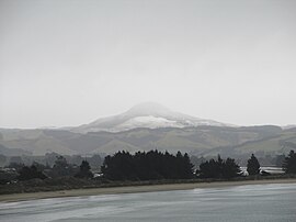
Mount MacKenzie / Pakihiwitahi is a hill in eastern Otago, New Zealand, roughly 11 kilometres (6.8 mi) northwest of the township of Waikouaiti. The hill is volcanic in origin, being associated with the Dunedin Volcanic Group, an intraplate volcanic field which was active during the Miocene. The volcanic material is believed to have resulted in the hill being a magnetic anomaly, with the terrain on the hill having a significantly lower magnetic response than the surrounding terrain.