National Register of Historic Places listings in Jefferson County, Wisconsin
Last updated
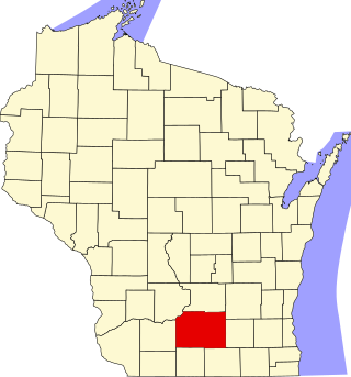
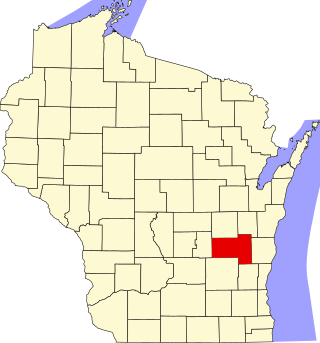
Location of Jefferson County in Wisconsin
This is a list of the National Register of Historic Places listings in Jefferson County, Wisconsin. It is intended to provide a comprehensive listing of entries in the National Register of Historic Places that are located in Jefferson County, Wisconsin. The locations of National Register properties for which the latitude and longitude coordinates are included below may be seen in a map.[1]
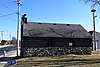
One-time village along the Crawfish River, which had three platform mounds and dwellings surrounded by a large stockade. The village was a northern outpost of Mississippian culture, occupied from around 900 to 1300 CE. Now a state park.
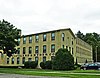
Four-story brick shoe factory built in 1904. Beals and Torrey had the largest payroll in Watertown from 1917 through 1954. The building housed the Kusel Dairy Equipment factory from the 1930s to 1960s.[6] Now apartments.[7]
Highly intact farm established in 1865 by German immigrants, which made the transition from wheat to dairy. Includes 1880 brick farmhouse, basement barn, milk-house, granary, machine shed, and privy.[8][9]
Depot of the C&NW, designed by Charles Sumner Frost in Victorian picturesque style and built of wood in 1903, with separate men's and women's waiting rooms and gas lighting fixtures.[12][13]
Two-row, country style, portable merry-go-round with hand-carved jumping horses, built in 1911 by C.W. Parker Amusement Co. of Leavenworth and now located at Firemen's Park.[14][15] Submerged in the 2008 flood of the Maunesha River. Restored by 2011 and moved to higher ground.[16]
Brick shoe factory complex, displaying utilitarian-industrial design. George Copeland and son-in-law Lewis Ryder started Jefferson Boot and Shoe in the late 1860s, mechanizing early and expanding. Oldest remaining buildings are from 1885, 1895, etc. In 1900, C-R was the largest manufacturer in Jefferson. Sold to Dr. Scholl's in 1946 and closed in 1977. Now remodeled as apartments.[30][31]
2-story commercial building built in the late 1840s, with cobblestone front, limestonequoins, and fieldstone sides. Originally housed a store, then Oliver Dow's Palmyra Enterprise for many years.[32][33]
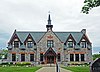
Private clubhouse designed by Charles Fitzgerald in Craftsman style and built in 1912, with card room, billiard room, dining room, gym and bowling alley. Housed a Masonic lodge from the 1930s to 90s.[39]
Early municipal water tower, with a 78-foot brick base supporting a 33-foot steel tank. The agreement to build it in 1901 was a landmark in the development of utilities in Fort Atkinson.
2.5-story cream brick Queen Anne-styled house, built in 1893. August worked in his family's Empire Brewery. Local milliner Clara Weiss lived in the house from 1893 to 1933.[40][41]
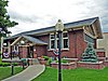
Highly intact 2-story town hall designed in simple Classical Revival style with a pediment in each gable end, built in 1902 by the Pollock Brothers and local residents. Now a museum.[42][43]
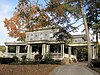
2-story Italianate-styled house built around 1860 for George Marston, storekeeper and brewer. Later owned by several prominent families, including Arthur R. Hoard of Hoard's Dairyman, who added Queen Anne elements to the house.
The 2-story main block with yellow Watertown brick and Italianate styling was designed by Alexander Kirkland and built in 1871. Adam Spangler designed a complementary expansion and the hose-drying tower, which were added in 1876.[46][47]
Two-story brick school designed in Collegiate Gothic style by Van Ryn & DeGelleke and Jefferson native Julius Heimerl, and built 1924-25. The 1953 addition was designed by Foeller, Schober, Berners, Safford and Jahn of Green Bay.[48][49]
Farm complex begun in the 1840s by Vermonter, pioneer and civic leader Milo Jones. When son Milo C. Jones developed arthritis in 1889 he tried making and selling sausage, which has grown into a successful meat-processing business.
38 historic buildings in the old downtown,[56] including the 1854 Kaltenbrun and Bruns hardware store and tin shop,[57] the 1876 commercial vernacular-style Foote building,[58] 1881 Joeckel building,[59] the 1883/1899 German Renaissance Revival-styled Greenwood's State Bank,[60] the 1890 Neupert Blacksmith shop,[61] the 1890 Gericke Brothers building,[62] the 1891 Yandre Brothers livery,[63] the 1892 Fargo Dairy Supply building,[64] the 1893 Queen Anne-styled Fargo block,[65] the 1895 Richardsonian Romanesque Williams block,[66] the 1900 Klein Wagon Shop,[67] the 1903 Dodge Creamery office building,[68] the 1907 Fargo building,[69] the 1921 Neoclassical-styled Greenwood's State Bank.[70] the 1923 20th-Century Commercial-styled Luetzow Meat Market,[71] and the 1931 Lake Mills Shoe Factory.[72]
Farm begun in 1870 by German immigrant Victor Loewe and wife Antionette, who started the Italianate-style house in 1872 and began selling drinking water from a spring on the farm, which led to Palmyra becoming a mineral springs resort. Later owned by William Weis, who ran a wholesale liquor business in Milwaukee, operated the farm as a dairy with Jersey cattle, and added many of the outbuildings around 1910. Woodrow and Gertrude Wilson bought the farm in 1950 and developed their own line of Holsteins there.[73][74][75]
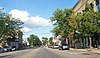
Fort Atkinson's old downtown, including the 1857 Italianate-styled Albert Winslow Grocery, the 1886 Dr. L.C. Bicknell Building (at left in photo), the 1894 Queen Anne-styled Andra saloon, the 1908 W.D. Hoard Publishing Co., and the 1929 Neoclassical Municipal Building.
The site where Fort Koshkonong (later named Fort Atkinson) was built during the Black Hawk War in 1832. In 1864 May built his elegant 2.5 story cream brick house on the site. May was a teacher, farmer, developer, banker and philanthropist.[92][93]
Greek Revival-styled house with walls of poured grout and a wooden cornice, built in 1846, which is early for concrete construction. McKenzie and his three boarders manufactured boots and shoes.[94][95]
Cluster of 10 large-scale historic homes,[96] including the 1853 Italianate-styled Griswold house,[97] the 1877 Second Empire-styled Frank Fargo house,[98] the 1893 Queen Anne Earl house,[99] and the 1897 Queen Anne Rev. Zimmerman house.[100]
Small, simple cottage clad in vertical logs on Blackhawk Island, where Objectivist poetLorine Niedecker lived in isolation and did some of her writing.[101]
3-story Italianate-styled brick octagon house with cupola and central spiral staircase, designed and built in 1854 by John Richards, pioneer attorney.[110]
Meeting hall of local Boy Scouts, built 1935-1937 by fathers of scouts and volunteers. Constructed of tamarack logs cut from Jolliffes' and Williams' swamps.[111]
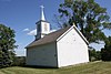
Site of Jefferson County's first incorporated village, settled in 1836, but largely abandoned by 1900 because it was bypassed by the railroads. The only remaining original building is the 1852 Greek Revival Baptist church.[112] Several historic cabins have been moved in from elsewhere for the museum.[113]
Four Italianate-styled buildings with party walls and elaborate brickwork, including James Barr's 1850 dry goods store which was the first brick store in Jefferson, Jacob Breunig's 1863 brewery and commercial block, and Nicholas Jung's dry goods store. Much of this was bought by Andreas Puerner in 1892 and developed into a department store which lasted in various forms until 1978.[114][115]
High Victorian Gothic church with 210-foot steeple, designed by Patrick Keely and built in 1872 by the largely Irish parish. Also an 1883 rectory and 1892 church school.
2.5-story Queen Anne-styled house with round corner turret, designed by Van Ryn, Andree & Lesser and built in 1893 by Frank Greve of Watertown for Emil Stoppenbach. Stoppenbach was a founder of the C. Stoppenbach & Sons packing plant.[141]
This is a list of the National Register of Historic Places listings in Dane County, Wisconsin. It aims to provide a comprehensive listing of buildings, sites, structures, districts, and objects in Dane County, Wisconsin listed on the National Register of Historic Places.
This is a list of the National Register of Historic Places listings in Waukesha County, Wisconsin. It is intended to provide a comprehensive listing of entries in the National Register of Historic Places that are located in Waukesha County, Wisconsin. The locations of National Register properties for which the latitude and longitude coordinates are included below may be seen in a map.
This is a list of the National Register of Historic Places listings in Winnebago County, Wisconsin.
This is a list of the National Register of Historic Places listings in Fond du Lac County, Wisconsin. It is intended to provide a comprehensive listing of entries in the National Register of Historic Places that are located in Fond du Lac County, Wisconsin. The locations of National Register properties for which the latitude and longitude coordinates are included below may be seen in a map.
This is a list of the National Register of Historic Places listings in Grant County, Wisconsin. It is intended to provide a comprehensive listing of entries in the National Register of Historic Places that are located in Grant County, Wisconsin. The locations of National Register properties for which the latitude and longitude coordinates are included below may be seen in a map.
This is a list of the National Register of Historic Places listings in Iowa County, Wisconsin. It is intended to provide a comprehensive listing of entries in the National Register of Historic Places that are located in Iowa County, Wisconsin. The locations of National Register properties for which the latitude and longitude coordinates are included below may be seen in a map.
This is a list of the National Register of Historic Places listings in La Crosse County, Wisconsin. It is intended to provide a comprehensive listing of entries in the National Register of Historic Places that are located in La Crosse County, Wisconsin. The locations of National Register properties for which the latitude and longitude coordinates are included below may be seen in a map.
This is a list of the National Register of Historic Places listings in Ozaukee County, Wisconsin. It is intended to provide a comprehensive listing of entries in the National Register of Historic Places that are located in Ozaukee County, Wisconsin. The locations of National Register properties for which the latitude and longitude coordinates are included below may be seen in a map.
This is a list of the National Register of Historic Places listings in Racine County, Wisconsin. It is intended to provide a comprehensive listing of entries in the National Register of Historic Places that are located in Racine County, Wisconsin. The locations of National Register properties for which the latitude and longitude coordinates are included below may be seen in a map.
This is a list of the National Register of Historic Places listings in Sheboygan County, Wisconsin. It is intended to provide a comprehensive listing of entries in the National Register of Historic Places that are located in Sheboygan County, Wisconsin. The locations of National Register properties for which the latitude and longitude coordinates are included below may be seen in a map.
This is a list of the National Register of Historic Places listings in Walworth County, Wisconsin. It is intended to provide a comprehensive listing of entries in the National Register of Historic Places that are located in Walworth County, Wisconsin. The locations of National Register properties for which the latitude and longitude coordinates are included below may be seen in a map.
This is a list of the National Register of Historic Places listings in Dodge County, Wisconsin. It is intended to provide a comprehensive listing of entries in the National Register of Historic Places that are located in Dodge County, Wisconsin. The locations of National Register properties for which the latitude and longitude coordinates are included below may be seen in a map.
This is a list of the National Register of Historic Places listings in Green County, Wisconsin. It is intended to provide a comprehensive listing of entries in the National Register of Historic Places that are located in Green County, Wisconsin. The locations of National Register properties for which the latitude and longitude coordinates are included below may be seen in a map.
This is a list of the National Register of Historic Places listings in Washington County, Wisconsin. It is intended to provide a comprehensive listing of entries in the National Register of Historic Places that are located in Washington County, Wisconsin. The locations of National Register properties for which the latitude and longitude coordinates are included below may be seen in a map.
This is a list of the National Register of Historic Places listings in Manitowoc County, Wisconsin. It is intended to provide a comprehensive listing of entries in the National Register of Historic Places that are located in Manitowoc County, Wisconsin. The locations of National Register properties for which the latitude and longitude coordinates are included below may be seen in a map.
This is a list of the National Register of Historic Places listings in Portage County, Wisconsin. It is intended to provide a comprehensive listing of entries in the National Register of Historic Places that are located in Portage County, Wisconsin. The locations of National Register properties for which the latitude and longitude coordinates are included below may be seen in a map.
This list comprises buildings, sites, structures, districts, and objects in the City of Milwaukee, Wisconsin, which are listed on the National Register of Historic Places. There are 286 NRHP sites listed in Milwaukee County, including 72 outside the City of Milwaukee included in the National Register of Historic Places listings in Milwaukee County, Wisconsin and 214 in the city, listed below. One previously listed site in the city has been removed.
References
↑ The latitude and longitude information provided is primarily from the National Register Information System, and has been found to be fairly accurate for about 99% of listings. For 1%, the location info may be way off. We seek to correct the coordinate information wherever it is found to be erroneous. Please leave a note in the Discussion page for this article if you believe any specific location is incorrect.
↑ Numbers represent an alphabetical ordering by significant words. Various colorings, defined here, differentiate National Historic Landmarks and historic districts from other NRHP buildings, structures, sites or objects.
↑ The eight-digit number below each date is the number assigned to each location in the National Register Information System database, which can be viewed by clicking the number.
This page is based on this Wikipedia article Text is available under the CC BY-SA 4.0 license; additional terms may apply. Images, videos and audio are available under their respective licenses.