National Register of Historic Places listings in Outagamie County, Wisconsin
Last updated
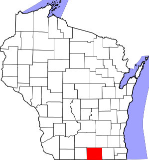
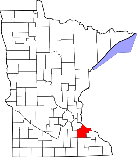
Location of Outagamie County in Wisconsin
This is a list of the National Register of Historic Places listings in Outagamie County, Wisconsin. It is intended to provide a comprehensive listing of entries in the National Register of Historic Places that are located in Outagamie County, Wisconsin. The locations of National Register properties for which the latitude and longitude coordinates are included below may be seen in a map.[1]
Part of the system of locks and dams built starting around 1851 to allow navigation of the Fox River from Green Bay to Portage. Maintained by the Army Corps of Engineers from 1872 to 1984, and used until 1987. Each lock now consists of a masonry chamber, wooden gates, and mechanical apparatus for operating the locks.[15]
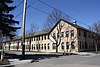
Factory built in 1896 by the first wire cloth company in the Midwest. Wire cloth is used by paper mills. The company expanded and in 1938 was the largest weaver of Fourdrinier wire in the world.[17]
Mill complex on the Fox River, begun in 1881 as a yarn factory, and expanded to produce mackinaws and flannels in 1888. Expanded to make papermakers' felt in 1890 and continued that until 1969. Once was "the only source of [that felt] east of Ohio."[18]
Large stone arch bridge across the Shioc River with four limestone arches. Designed by John Hayes of Appleton, who designed most of the early stone-arch bridges in the county, and built by James Garvey in 1905-06. Now a pedestrian crossing.[19]
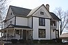
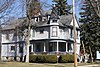
Queen Anne house with three-story corner tower and exterior of cut stone, built in 1898. Merritt was a farmer, well-driller, realtor, and owned the quarry which produced the stone that covers the house.[20]
Lock, dam and canal to allow navigation of this section of the Fox River. Construction of the lock began in 1850 and it was rebuilt around 1888. Current lock has limestone walls and wooden gates. Nearby is a Dutch Colonial Revival locktender's house built in 1927. The lock is named for the Treaty of the Cedars, which was signed with the Menominee in 1836 on the riverbank nearby.[22]
First paper mill in Kaukauna, initially making paper in 1872 from farmers' straw and cloth rags using hydro power from the Fox. Soon after under Henry Frambach was the first mill in the state to make paper from wood pulp.[35] Began as a flour mill.[36]
Neoclassical store built in 1928, originally with Bert Fargo's furniture showroom downstairs and undertaker business upstairs. His father George had begun the family business in Kaukauna in 1881, describing his enterprise in 1890 as "an undertaking business, repairing, picture framing, large stock of wallpaper, and furniture."[37]
2.5 story American Foursquare house with Craftsman detailing and a porte cochere, designed by Herman Wildhagen of Appleton and built in 1921. William started a milk delivery business, ran a greenhouse adjacent to this house, served as clerk for the Kimberley School District many years, and served as vice-president of the State Bank of Little Chute for 34 years.[43]
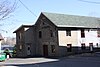
2.5 story Federal-style house built in 1836, once known as "the Mansion in the Woods." Served as inn, church, trading post, and Indian meeting place. Grignon's French-Canadian family had run a trading post at Kaukauna since at least 1760. Charles continued the fur trade and was U.S. interpreter at all treaties with the Menominee from 1830 to 1862. Now a museum.[45]
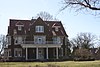
1881 home with nine fireplaces designed by William Waters in Queen Anne style for Henry Rogers, who ran the Appleton Paper and Pulp Company. In 1882 it became the first private home in the nation lit with electricity from an Edison central hydroelectric power station, which was located at the paper mill's plant on the river below.[46][47]
Neogothic/Romanesque church built in 1916. Holy Cross is the original Roman Catholic parish in Kaukauna, with a previous church building on the site built in 1873 and the Grignons included among its early members.[48]
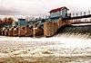
Part of the Fox–Wisconsin Waterway: five locks with hand-operated wooden gates, a guard lock, a dam, canal, boathouse, drydock, lock-keeper's house, and various sheds.[50] All help vessels around a 50-foot rapids in the Fox River. Constructed in the 1850s by private companies. Largely rebuilt in the 1880s by the Army Corps of Engineers.[51]
The 1892 Queen Anne-styled house with square corner turret is a remnant of a large dairy farm. The Kleins immigrated from Germany in 1842 and over the years farmed, ran a flour and feed mill, and sold milk to households from a horse-drawn cart.[52]
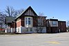
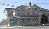
1897 hotel built with 5 bedrooms to serve travelers on the railroad. Also housed railroad ticket office, barber shop, bus stop, funeral parlor, and served as community meeting place.[53][54]
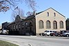
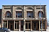
Brick Romanesque Revival store built in 1891 around two earlier buildings by Julius Kuehn, blacksmith and later mayor. By 1911, Fred Merbach owned the building, advertising general hardware, furniture, and undertaking services.[55]
3-story Romanesque Revival commercial building built in 1895, during the railroad boom. After Luther Lindauer lost a hand in a planing mill accident, he drove horses, worked on the canal, ran a quarry, an ice business, a fuel business, a brickyard, and served as mayor of Kaukauna for 3 terms. His building later housed the Elks Club for many years.[56]
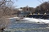
Navigation canal with locks, fed by a 561-foot concrete dam, and supported by other miscellaneous structures. Initially built around 1850 and upgraded at various times since.[57][58] Part of the Fox–Wisconsin Waterway.
Italianate-styled store built in 1901, with retail space on first floor and elegant apartments on the second. Martens originally sold dry goods, groceries and crockery downstairs. He also served various civic roles, in other businesses, and organized Kaukauna's first successful farmers' market.[60]
1884 Italianate villa with a 3-story square tower. Meade led a company of Wisconsin volunteers which marched with Sherman through Georgia. He invested in land in the Fox valley, developed a power canal along the river in front of this house, and served in the State Senate.[63]
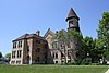
Designed by local architect Phillip Deane in Romanesque Revival style and built in 1891, the school was named for Jean Nicolet, who probably visited Kaukauna in 1634.[64]
1911 stucco-clad bungalow with leaded stained glass windows and oak-trimmed interior, largely intact. One of the best examples of a bungalow in Kaukauna.[70]
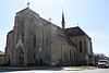
Neogothic Revival church with cruciform floor plan, designed by Adolphus Druiding and built in 1898 with European influences for the largely German and Irish congregation which grew during south Kaukauna's (Ledyard's) boom in rail and water power.[71]
Meeting hall of the local chapter of the Grange, a national farmers' organization. The 2-story brick building also served as a general community center.[74][75]
Elegant 3-story Tudor Revival house facing the Fox River, designed by Van Ryn & DeGelleke and built in 1910. It has a red tile roof, stained glass windows, marble thresholds, and a 175-year-old hand-carved fireplace, yet also an early central vacuum system and telephone intercom. Stribley rose from bookkeeper to director at Thilmany Pulp and Paper Co. and was a key founder of the Outagamie County Teachers' College.[76]
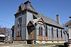
Stick-stylesynagogue built by the local Jewish community in 1883, one of the earliest in Wisconsin.[5][77] A young Edna Ferber worshiped there, and Harry Houdini's father was rabbi of the congregation just before moving to this building, but was dismissed because he preached only in German. Now houses Wahl Organbuilders.[78]
1868 Italianate home[79] with "grout block" exterior.[80] James was a pioneer farmer in Greenville from 1848, then moved to Appleton in 1865 and founded the Empire Soap Company.[81]
Victorian brick house with 3-story corner tower designed in Italianate style by William Waters and built in 1870. Whorton owned lumber mills and was a bank president.[90]
High VictorianItalianate commercial building with an elaborate corner tower, built in 1891 to house an independent German newspaper. A.k.a. W. A. Close Store. Damaged by fire in 1981 and demolished.[93][94]
Outagamie County is a county in the northeast region of the U.S. state of Wisconsin. As of the 2020 census, the population was 190,705. Its county seat is Appleton.
Kaukauna is a city in Outagamie and Calumet counties, Wisconsin, United States. It is situated on the Fox River, approximately 100 miles (160 km) north of Milwaukee. The population was 15,462 at the 2010 census. It is a part of the Appleton, Wisconsin Metropolitan Statistical Area.
This is a list of the National Register of Historic Places listings in Rock County, Wisconsin. It is intended to provide a comprehensive listing of entries in the National Register of Historic Places that are located in Rock County, Wisconsin. The locations of National Register properties for which the latitude and longitude coordinates are included below may be seen in a map.
This is a list of the National Register of Historic Places listings in Dakota County, Minnesota. It is intended to be a complete list of the properties and districts on the National Register of Historic Places in Dakota County, Minnesota, United States. Dakota County is located in the southeastern part of the U.S. state of Minnesota, bounded on the northeast side by the Upper Mississippi River and on the northwest by the Minnesota River. The locations of National Register properties and districts for which the latitude and longitude coordinates are included below, may be seen in an online map.
This is a list of the National Register of Historic Places listings in Winnebago County, Wisconsin.
This is a list of the National Register of Historic Places listings in Sauk County, Wisconsin. It is intended to provide a comprehensive listing of entries in the National Register of Historic Places that are located in Sauk County, Wisconsin. The locations of National Register properties for which the latitude and longitude coordinates are included below may be seen in a map.
This is a list of the National Register of Historic Places listings in Brown County, Wisconsin. It is intended to provide a comprehensive listing of entries in the National Register of Historic Places that are located in Brown County, Wisconsin. The locations of National Register properties for which the latitude and longitude coordinates are included below may be seen in a map.
This is a list of the National Register of Historic Places listings in Columbia County, Wisconsin.
This is a list of the National Register of Historic Places listings in Door County, Wisconsin. It is intended to provide a comprehensive listing of entries in the National Register of Historic Places that are located in Door County, Wisconsin. The locations of National Register properties for which the latitude and longitude coordinates are included below may be seen in a map.
This is a list of the National Register of Historic Places listings in Grant County, Wisconsin. It is intended to provide a comprehensive listing of entries in the National Register of Historic Places that are located in Grant County, Wisconsin. The locations of National Register properties for which the latitude and longitude coordinates are included below may be seen in a map.
This is a list of the National Register of Historic Places listings in La Crosse County, Wisconsin. It is intended to provide a comprehensive listing of entries in the National Register of Historic Places that are located in La Crosse County, Wisconsin. The locations of National Register properties for which the latitude and longitude coordinates are included below may be seen in a map.
This is a list of the National Register of Historic Places listings in Ozaukee County, Wisconsin. It is intended to provide a comprehensive listing of entries in the National Register of Historic Places that are located in Ozaukee County, Wisconsin. The locations of National Register properties for which the latitude and longitude coordinates are included below may be seen in a map.
This is a list of the National Register of Historic Places listings in Sheboygan County, Wisconsin. It is intended to provide a comprehensive listing of entries in the National Register of Historic Places that are located in Sheboygan County, Wisconsin. The locations of National Register properties for which the latitude and longitude coordinates are included below may be seen in a map.
This is a list of the National Register of Historic Places listings in Walworth County, Wisconsin. It is intended to provide a comprehensive listing of entries in the National Register of Historic Places that are located in Walworth County, Wisconsin. The locations of National Register properties for which the latitude and longitude coordinates are included below may be seen in a map.
This is a list of the National Register of Historic Places listings in Goodhue County, Minnesota. It is intended to be a complete list of the properties and districts on the National Register of Historic Places in Goodhue County, Minnesota, United States. The locations of National Register properties and districts for which the latitude and longitude coordinates are included below, may be seen in an online map.
Washington Avenue Historic District is the historic center of Cedarburg, Wisconsin, the location of the early industry and commerce that was key to the community's development. The historic district was listed on the National Register of Historic Places (NRHP) in 1986.
This is a list of the National Register of Historic Places listings in Manitowoc County, Wisconsin. It is intended to provide a comprehensive listing of entries in the National Register of Historic Places that are located in Manitowoc County, Wisconsin. The locations of National Register properties for which the latitude and longitude coordinates are included below may be seen in a map.
This is a list of the National Register of Historic Places listings in Portage County, Wisconsin. It is intended to provide a comprehensive listing of entries in the National Register of Historic Places that are located in Portage County, Wisconsin. The locations of National Register properties for which the latitude and longitude coordinates are included below may be seen in a map.
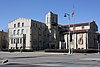
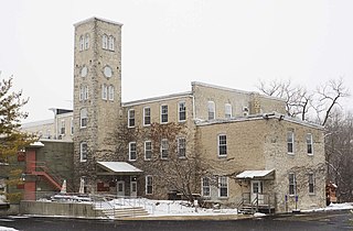
St. Mary's Catholic Church is a Roman Catholic church in Kaukauna, Wisconsin. It was added to the National Register of Historic Places in 1984 for its significance in architecture and community planning and development.
The Cedarburg Woolen Co. Worsted Mill is a former woolen mill on the Milwaukee River in Grafton, Wisconsin. In the late-1800s, the Cedarburg Woolen Company in neighboring Cedarburg decided to expand their production by opening a second mill.
References
↑ The latitude and longitude information provided is primarily from the National Register Information System, and has been found to be fairly accurate for about 99% of listings. For 1%, the location info may be way off. We seek to correct the coordinate information wherever it is found to be erroneous. Please leave a note in the Discussion page for this article if you believe any specific location is incorrect.
1 2 Numbers represent an alphabetical ordering by significant words. Various colorings, defined here, differentiate National Historic Landmarks and historic districts from other NRHP buildings, structures, sites or objects.
↑ The eight-digit number below each date is the number assigned to each location in the National Register Information System database, which can be viewed by clicking the number.
↑ Geenen, David J. (1992-09-30). "Geenen, William and Susanna, House". National Register of Historic Places Nomination Form. US Department of the Interior. National Park Service. Retrieved 2015-02-07.
↑ Richards, Dr. John D.; Lusk, Georgia A.; Richards, Patricia B.; Watson, Robert J. "Kaukauna Locks and Dam"(PDF). Historic American Engineering Record. National Park Service. Retrieved 2015-02-01.
This page is based on this Wikipedia article Text is available under the CC BY-SA 4.0 license; additional terms may apply. Images, videos and audio are available under their respective licenses.