

The following outline is provided as an overview of and topical guide to Egypt:
Contents
- General reference
- Geography of Egypt
- Environment of Egypt
- Regions of Egypt
- Demography of Egypt
- Government and politics of Egypt
- Branches of the government of Egypt
- Foreign relations of Egypt
- Law and order in Egypt
- Media of Egypt
- Military of Egypt
- History of Egypt
- History of Egypt, by period
- History of Egypt, by region
- History of Egypt, by subject
- Culture of Egypt
- Art in Egypt
- Sports in Egypt
- Economy and infrastructure of Egypt
- Education in Egypt
- See also
- References
- External links
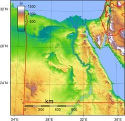
Egypt , officially the Arab Republic of Egypt, is a country spanning the northeast corner of Africa and southwest corner of Asia via the Sinai Peninsula . It is bordered by the Mediterranean Sea to the north , Palestine and Israel to the northeast , the Red Sea to the east, Sudan to the south , and Libya to the west . The Gulf of Aqaba in the northeast separates Egypt from Jordan and Saudi Arabia . Cairo is the capital, largest city , and leading cultural center, while Alexandria is the second-largest city and an important hub of industry and tourism. With over 107 million inhabitants, Egypt is the third-most populous country in Africa and 15th-most populated in the world .