
Gila Bend, founded in 1872, is a town in Maricopa County, Arizona, United States. The town is named for an approximately 90-degree bend in the Gila River, which is near the community's current location. As of the 2020 census, the population of the town was 1,892.

Hohokam was a culture in the North American Southwest in what is now part of Arizona, United States, and Sonora, Mexico. It existed between 300 and 1500 AD, with cultural precursors possibly as early as 300 BC. Archaeologists disagree about whether communities that practiced the culture were related or politically united. According to local oral tradition, Hohokam societies may be the ancestors of the historic Pima and Tohono O'odham peoples in Southern Arizona.

Mogollon culture is an archaeological culture of Native American peoples from Southern New Mexico and Arizona, Northern Sonora and Chihuahua, and Western Texas. The northern part of this region is Oasisamerica, while the southern span of the Mogollon culture is known as Aridoamerica.
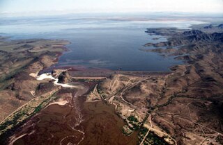
The Painted Rock Dam is an earthfill embankment dam located west of Gila Bend, Arizona. It is primarily used for flood control purposes.

The Hohokam Pima National Monument is an ancient Hohokam village within the Gila River Indian Community, near present-day Sacaton, Arizona. The monument features the archaeological site Snaketown 30 miles (48 km) southeast of Phoenix, Arizona, designated a National Historic Landmark in 1964. The area was further protected by declaring it a national monument in 1972, and was listed on the National Register of Historic Places in 1974.
Patayan is a group of prehistoric and historic Native American cultures in parts of modern-day Arizona, west to Lake Cahuilla in California, and in Baja California, from AD 700 to 1550. This included areas along the Gila River, Colorado River and in the Lower Colorado River Valley, the nearby uplands, and north to the vicinity of the Grand Canyon.

Tumamoc Hill is a butte located immediately west of "A" Mountain and downtown Tucson, Arizona. It is home to many radio, television, and public safety transmitters. The 860-acre ecological reserve and U.S. National Historic Landmark was established by the Carnegie Institution in 1903. The University of Arizona (UA) owns a 340-acre (1.4 km2) preserve and leases another 509 acres (2.06 km2) as a research and education facility. The Steward Observatory maintains a small astronomical observatory with a 20-inch (510 mm) telescope on the hill. Besides being a prominent landmark, Tumamoc Hill has a long and varied history, and is currently an important site for ecological and anthropological research as well as a refuge and a recreational option for the people of Tucson. The Desert Laboratory located on Tumamoc welcomed a new director, Ben Wilder, as of 2018.
The Crow Canyon Archaeological District is located in the heart of the Dinétah region of the American Southwest in Rio Arriba and San Juan counties in New Mexico approximately 30 miles southeast of the city of Farmington. This region, known to be the ancestral homeland of the Navajo people, contains the most extensive collection of Navajo and Ancient Pueblo petroglyphs or rock art in the United States. Etched into rock panels on the lower southwest walls of the canyon are petroglyphs or rock art depicting what is believed to be ceremonial scenes and symbolic images that represent the stories, traditions and beliefs of the Navajo people. Dating back to the 16th, 17th, and 18th centuries, the petroglyphs have maintained their integrity despite the environmental conditions of the canyon and the effects of tourism. Among the ruins in the Crow Canyon Archaeological District there is also a cluster of Navajo defensive structures or pueblitos, which were built in the 18th century during periods of conflict with the Utes and the beginnings of Spanish Colonialism.
Southwestern archaeology is a branch of archaeology concerned with the Southwestern United States and Northwestern Mexico. This region was first occupied by hunter-gatherers, and thousands of years later by advanced civilizations, such as the Ancestral Puebloans, the Hohokam, and the Mogollon.

The Gatlin Site is an archaeological site in Gila Bend, Arizona. The site preserves one of the few documented Hohokam platform mounds. Associated with the mound are pit houses, ball courts, middens, and prehistoric canals. Between AD 800 and 1200 it was an important Hohokam settlement at the great bend of the Gila River. The Hohokam people were the first farmers in southern Arizona, where the permanent Salt and Gila Rivers flowing through the hot Sonoran Desert made the irrigation strategy possible. The site is the largest in the area and was home to over 500 people. Its importance is indicated by the presence of two ceremonial ball courts and one of the earliest platform mounds known. The mound is notable as being one of only few excavated and documented Sedentary Period platform mounds still relatively intact. The site was declared a National Historic Landmark in 1964.

Pueblo Grande Ruin and Irrigation Sites are pre-Columbian archaeological sites and ruins, located in Phoenix, Arizona. They include a prehistoric platform mound and irrigation canals. The City of Phoenix manages these resources as the Pueblo Grande Museum Archaeological Park.

Mesa Grande Cultural Park, in Mesa, Arizona, preserves a group of Hohokam structures constructed during the Classic Period. The ruins were occupied between AD 1100 and 1400 and were a product of the Hohokam civilization that inhabited the Salt River Valley. There the Hohokam constructed an extensive system of water canals. It is one of only two Hohokam mounds remaining in the metro Phoenix area, with the other being the Pueblo Grande Museum Archaeological Park. The site's central feature is a massive ruin of adobe walls and platforms.
La Proveedora is an archeological site located some 15 kilometers west of the city of Caborca, Sonora, México, on the “La Proveedora” and “San José” hills within the “Rancho Puerto Blanco” Ejido, where most of these petroglyphs are located.

Painting in the Americas before European colonization is the Precolumbian painting traditions of the Americas. Painting was a relatively widespread, popular and diverse means of communication and expression for both religious and utilitarian purpose throughout the regions of the Western Hemisphere. During the period before and after European exploration and settlement of the Americas; including North America, Central America, South America and the islands of the Caribbean, the Bahamas, the West Indies, the Antilles, the Lesser Antilles and other island groups, indigenous native cultures produced a wide variety of visual arts, including painting on textiles, hides, rock and cave surfaces, bodies especially faces, ceramics, architectural features including interior murals, wood panels, and other available surfaces. Many of the perishable surfaces, such as woven textiles, typically have not been preserved, but Precolumbian painting on ceramics, walls, and rocks have survived more frequently.

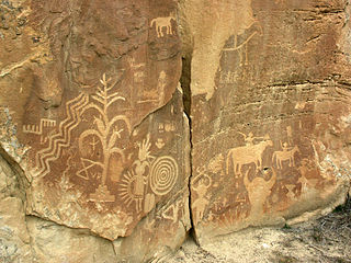
The Deer Valley Petroglyph Preserve, formerly known as the Deer Valley Rock Art Center, is a 47-acre nature preserve featuring over 1500 Hohokam, Patayan, and Archaic petroglyphs visible on 500 basalt boulders in the Deer Valley area of Phoenix, Arizona. In 1980, the US Army Corps of Engineers contracted Simon J. Bruder to conduct an archaeological investigation prior to the construction of the Adobe Dam at the Hedgpeth Hills. The petroglyphs are between 500 and 5,000 years old. The site was listed on the National Register of Historic Places in 1984, and it was also listed with the Phoenix Points of Pride. The preserve and museum are operated by the ASU College of Liberal Arts and Sciences's School of Human Evolution and Social Change.

Black Mountain is a lava capped mesa in Pima County, Arizona, that rises 1,000 feet above its base to an altitude of 3,700 feet (1,128 m). It is a northeast trending ridge, 5,600 feet in length, located along Mission Road nine miles southwest of Tucson. It is on the San Xavier Indian Reservation, 3.18 miles southwest of the Mission San Xavier del Bac. The Sierrita Mountains rise to the southwest and the Santa Cruz River is about four miles to the east.
Norton Allen (1909–1997) was an American artist and avocational archaeologist who worked in the American Southwest, primarily in California and Arizona.

The Painted Rocks Mountains are a short 15-mile (24 km) long mountain range of the north-central Sonoran Desert southwest of Phoenix, Arizona and in southwest Maricopa County. The Gila River flows through the central-north end of the range.

The Indigenous peoples of the North American Southwest are those in the current states of Colorado, Arizona, New Mexico, Utah, and Nevada in the western United States, and the states of Sonora and Chihuahua in northern Mexico. An often quoted statement from Erik Reed (1964) defined the Greater Southwest culture area as extending north to south from Durango, Mexico to Durango, Colorado and east to west from Las Vegas, Nevada to Las Vegas, New Mexico. Other names sometimes used to define the region include "American Southwest", "Northern Mexico", "Chichimeca", and "Oasisamerica/Aridoamerica". This region has long been occupied by hunter-gatherers and agricultural people.

