
Ulster County is a county in the U.S. state of New York. It is situated along the Hudson River. As of the 2020 census, the population was 181,851. The county seat is Kingston. The county is named after the Irish province of Ulster. The county is part of the Hudson Valley region of the state.

East Kingston is a hamlet in Ulster County, New York, United States. The population was 277 at the 2020 census.

Ellenville is a village within the town of Wawarsing, Ulster County, New York, United States. Its population was 4,167 at the 2020 census.

Esopus is a town in Ulster County, New York, United States. The population was 9,548 at the 2020 census. The town was named after the local indigenous tribe and previously thought to mean "small river" in English. However, in the Lenape` language, the word translates to "Wellspring of Creation". The Esopus people were one of the Lenape (Delaware) bands, belonging to a people who ranged from western Connecticut through lower New York, western Long Island, and parts of New Jersey and Pennsylvania along the Delaware River. The town is on the west bank of the Hudson River south of the city of Kingston. Its center is in Port Ewen. US Route 9W passes along the eastern side of the town.

Kerhonkson is a hamlet and census-designated place (CDP) in Ulster County, New York, United States. The population was 1,722 at the 2020 census.

Rifton is a hamlet in Ulster County, New York, United States. The population was 481 at the 2020 census.

Rosendale is a town in the center of Ulster County, New York, United States. It once contained a village Rosendale, primarily centered around Main Street, but which was dissolved through vote in 1977. The population was 5,782 at the 2020 census.

Rosendale is a hamlet located in the Town of Rosendale in Ulster County, New York, United States. The population was 1,285 at the 2020 census. It was also a census-designated place known as Rosendale Village until 2010, when the U.S. Census Bureau designated it Rosendale Hamlet. Some maps continue to list the place as just Rosendale. As of 2020, the "Hamlet" in the CDP name was dropped.

Ulster is a town in Ulster County, New York, United States. The population was 12,660 at the 2020 census.

Wallkill is a hamlet, generally identified as coterminous with ZIP code 12589, telephone exchange 895 in the 845 area code and most of the Wallkill Central School District located mostly in the eastern half of the town of Shawangunk, Ulster County, New York, United States, but partly spilling over into adjacent regions of the Orange County towns of Newburgh and Montgomery. The population was 2,166 at the 2020 census.
Rondout Creek is a 63.3-mile-long (101.9 km) tributary of the Hudson River in Ulster and Sullivan counties, New York, United States. It rises on Rocky Mountain in the eastern Catskills, flows south into Rondout Reservoir, part of New York City's water supply network, then into the valley between the Catskills and the Shawangunk Ridge, where it goes over High Falls and finally out to the Hudson at Kingston, receiving along the way the Wallkill River.

The Kingston–Port Ewen Suspension Bridge, sometimes known as the "Rondout Creek bridge", "Old Bridge" or "Wurts Street Bridge", is a steel suspension bridge spanning Rondout Creek, near where it empties into the Hudson River. It connects the City of Kingston to the north, with the village of Port Ewen to the south. Completed in 1921, it was the final link in New York's first north-south highway on the West Shore of the Hudson, and is considered an important engineering accomplishment associated with the development of early motoring.
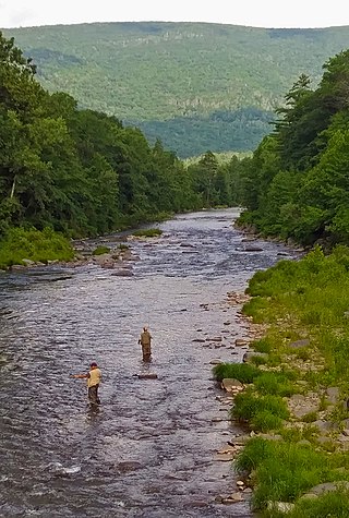
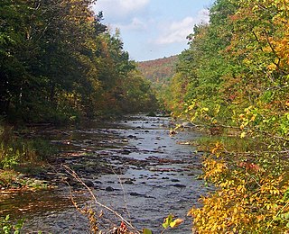
Esopus Creek is a 65.4-mile-long (105.3 km) tributary of the Hudson River that drains the east-central Catskill Mountains in the U.S. state of New York. From its source at Winnisook Lake on the slopes of Slide Mountain, the Catskills' highest peak, it flows across Ulster County to the Hudson at Saugerties. Many tributaries extend its watershed into neighboring Greene County and a small portion of Delaware County. Midway along its length, it is impounded at Olive Bridge to create Ashokan Reservoir, the first of several built in the Catskills as part of New York City's water supply system. Its own flow is supplemented 13 miles (21 km) above the reservoir by the Shandaken Tunnel, which carries water from the city's Schoharie Reservoir into the creek.

New York State Route 213 (NY 213) is a state highway located entirely in Ulster County. It runs from the eastern Catskills to downtown Kingston.

Rondout, is situated in Ulster County, New York, on the Hudson River at the mouth of Rondout Creek. Originally a maritime village, the arrival of the Delaware and Hudson Canal helped create a city that dwarfed nearby Kingston. Rondout became the third largest port on the Hudson River. Rondout merged with Kingston in 1872. It now includes the Rondout–West Strand Historic District.
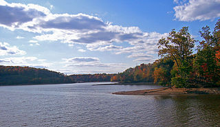
Sturgeon Pool is a reservoir near the hamlet of Rifton, in the Town of Esopus in Ulster County, New York.

The Rondout–West Strand Historic District is located on the shore of Rondout Creek along the southern boundary of the city of Kingston, New York, United States. Formerly Rondout, New York, it is bounded by the creek, Broadway, Hone, Ravine and McEntee streets, an area of 570 acres (2.3 km²) containing 259 buildings, most dating to the 19th century. US 9W and the John T. Loughran Bridge are immediately to the east; the Kingston-Port Ewen Suspension Bridge crosses the creek to the west. The neighborhood is often referred to locally by either of the two names.

Hurley is a hamlet in the Town of Hurley, Ulster County, New York, United States. The population was 3,346 at the 2020 census.

Kingston is the only city in, and the county seat of, Ulster County, New York, United States. It is 91 miles (146 km) north of New York City and 59 miles (95 km) south of Albany. The city's metropolitan area is grouped with the New York metropolitan area around Manhattan by the United States Census Bureau. The population was 24,069 at the 2020 United States Census.
Saugerties is a town in the northeastern corner of Ulster County, New York. The population was 19,038 at the time of the 2020 Census, a decline from 19,482 in 2010. The village of the same name is located entirely within the town.


