Rochester Hills, Michigan

Last updated
Rochester Hills, Michigan
City of Rochester Hills
Autumn at Spencer Park.jpg
Autumn Sunrise at Spencer Park.
Flag of Rochester Hills, Michigan.svg
Rochester Hills, MI location.png
Location within Oakland County
USA Michigan location map.svg
Red pog.svg
Rochester Hills
Location within the state of Michigan
Coordinates: 42°39′57″N83°09′29″W / 42.66583°N 83.15806°W / 42.66583; -83.15806
Country United States
State Michigan
County Oakland
Settled1817
Organized1835 (Avon Township)
Incorporated1984 (City of Rochester Hills)
Government
  Type Mayor–council
   Mayor Bryan K. Barnett (R)
   Clerk Leanne Scott
Area
[1]
   City 32.90 sq mi (85.22 km2)
  Land32.80 sq mi (84.96 km2)
  Water0.10 sq mi (0.25 km2)
Elevation
820 ft (250 m)
Population
 (2020)
   City 76,300
  Density2,325.94/sq mi (898.06/km2)
   Metro
4,296,250 (Metro Detroit)
Time zone UTC-5 (Eastern (EST))
  Summer (DST) UTC-4 (EDT)
ZIP code(s)
48306–48309
Area code(s) 248 and 947
FIPS code26-69035 [2]
GNIS feature ID1675440 [3]
Website Official website

Rochester Hills is a city in Oakland County in the U.S. state of Michigan. As of the 2020 census, the city had a total population of 76,300. [4] It is the 14th-largest city in Michigan. [5] It has also ranked as the safest city in Michigan for the past seven years. [6]

Contents

The area was first settled by European Americans in 1817, and organized as Avon Township in 1835. The City of Rochester incorporated in 1967, while the remaining area of Avon Township was incorporated and renamed the City of Rochester Hills in 1984. Considered a northern suburb of Metro Detroit, Rochester Hills is about 12 miles (19.3 km) north of Detroit.

Communities

History

Prior to European settlement, the area now known as Rochester Hills was inhabited by Native Americans, namely the Potawatomi. [9] The Potawatomi depended on the area's abundant water sources, such as the Clinton River and Paint Creek, to grow crops, fish, and travel. [9] [10] They resided here until the 1807 Treaty of Detroit caused them, along with the Odawa, Wyandot, and Ojibwe peoples, to cede their land in Southeast Michigan. [11] [12]

The first European settler was James Graham who arrived in 1817. Graham and his family reached the area by following trails created by the Sauk Native Americans. [13] [14] Avon Township was organized in 1835. Rochester incorporated as a village within the township in 1869. The township adopted a charter in 1948 under the Home Rule Act. Also in 1948 a post office was established under the name of Brooklands for the area between Auburn Road and Hamlin Road just to the west of Dequindre Road. [15]

In 1966, village residents voted to become the City of Rochester, effective in February 1967. As a result, Rochester residents no longer had to pay property taxes to the township, as it was now a separate municipality.

In 1967, Avon Township filed a petition to become a city. In January 1968, township voters approved the petition to move forward with seeking city status. Three proposed city charters were voted down by residents, the first in March 1969, the second in May 1970, and the third in September 1971. The city of Rochester then sought to annex all of the township, which was unanimously denied by the Michigan Boundary Commission. In 1972, petitions were filed to consolidate Avon Township and Rochester. In April 1974, the consolidation petition lost by 350 votes in the township, while passing by four votes in Rochester. In May 1974, Rochester's petition to annex 2.2 square miles (5.7 km2) of Avon Township was approved by the Michigan Boundary Commission, depriving Avon Township of its largest taxpayer. [16] The township became Avon Charter Township in August 1978. Court challenges to the 1974 annexation continued until November 1981, when the township was ordered to surrender the annexed property. An impending annexation request from the City of Troy, due south, for 300 acres of southeast Avon Township brought the cityhood question to a crisis. [16]

In May 1984, township voters approved a city charter. On November 20, 1984, Avon Township became the City of Rochester Hills. The name of the new city was put to a vote, with the other choice being "Avon Hills." The name "Rochester Hills" won by a landslide with voters, based on the area's historical ties to Rochester and the rolling hills in the area. Township Supervisor Earl E. Borden became the first mayor of Rochester Hills.

Geography

According to the United States Census Bureau, the city has a total area of 32.91 square miles (85.24 km2), of which 32.82 square miles (85.00 km2) is land and 0.09 square miles (0.23 km2) (0.27%) is water. [17]

Rochester Hills is bordered to the north by Oakland Charter Township along Dutton Road, to the south by the city of Troy along South Boulevard, to the east by Shelby Township in Macomb County along Dequindre Road, and to the west by the city of Auburn Hills along part of Adams Road. Rochester Hills is also partially bordered by the city of Rochester to the east. Elevations in the city range from 690 feet (210 m) above sea level in the southeastern portion of the city to 1,032 feet (315 m) in the northwestern section.

Demographics

Historical population
CensusPop.Note
1990 61,766
2000 68,82511.4%
2010 70,9953.2%
2020 76,2937.5%
U.S. Decennial Census [18]

2020 census

As of the 2020 census, [19] there were 76,293 people, in 28,766 households, residing in the city. The population density was 2,359.9 inhabitants per square mile (911.2/km2). The racial makeup of the city was 79.6% White, 12.8% Asian, 3.7% African American, 2.9% from two or more races, and 0.1% Native American. Hispanic or Latino of any race were 5.6% of the population. 19.8% of the population was foreign-born. [20]

There were 28,766 households, and the median household income was $99,666. 4.2% of persons were living in poverty. 77.4% of residents lived in owner-occupied housing units.

Between 2000 and 2010, the Asian population in Rochester Hills increased to almost 10% of the community's population, a 61% increase from the 2000 figure. [21] It grew to 12.8% in 2020. [20]

2010 census

As of the census [22] of 2010, there were 70,995 people, 27,578 households, and 19,308 families residing in the city. The population density was 2,163.2 inhabitants per square mile (835.2/km2). There were 29,494 housing units at an average density of 898.7 per square mile (347.0/km2). The racial makeup of the city was 89.1% White, 2.5% African American, 0.2% Native American, 4.5% Asian, 0.7% from other races, and 1.9% from two or more races. Hispanic or Latino of any race were 1.1% of the population.

There were 27,578 households of which 33.2% had children under the age of 18 living with them, 59.2% were married couples living together, 8.1% had a female householder with no husband present, 2.8% had a male householder with no wife present, and 30.0% were non-families. 25.7% of all households were made up of individuals and 10.3% had someone living alone who was 65 years of age or older. The average household size was 2.53 and the average family size was 3.08.

The median age in the city was 40.9 years. 23.7% of residents were under the age of 18; 7.7% were between the ages of 18 and 24; 24.6% were from 25 to 44; 30.3% were from 45 to 64; and 13.8% were 65 years of age or older. The gender makeup of the city was 48.4% male and 51.6% female.

Government

Rochester Hills Public Library, Rochester, Michigan. Rochester Michigan Public Library.JPG
Rochester Hills Public Library, Rochester, Michigan.

Rochester Hills has a mayor-council government. The Rochester Hills City Council consists of seven Council Members: four district members and three at-large members. They are elected to four-year terms and, due to term limiting, can serve no more than two terms for a maximum of eight years. However, there are no limits on how many times the mayor can run for re-election as a write-in candidate.

Rochester Hills does not have a police department, so the city's police services are provided by the Oakland County Sheriff's Office. The 52nd District Court Division Three is also located in Rochester Hills.

In the 2020 United States presidential election in Michigan, 23,173 (50.67%) votes went to Joseph Biden and 21,680 (47.4%) votes were cast for Donald Trump. [23]

Federally, Rochester Hills is split between Michigan's 8th congressional district, represented by Democrat Elissa Slotkin, and Michigan's 11th congressional district, represented by Democrat Haley Stevens. However, as of 2023, Rochester Hills will be appended to the Macomb County-centered Michigan's 10th congressional district. [24]

Education

Rochester Community Schools serve most of the city. Rochester Adams High School, Rochester High School, and Stoney Creek High School are in Rochester Hills. The city also hosts college and graduate-level programs in various disciplines at Oakland University and Rochester Christian University.

Some portions of the city, however, are in the Avondale School District. Much of the ASD portion of Rochester Hills is zoned to Deerfield Elementary School, also within the city. Other portions are zoned to Auburn Elementary School in Auburn Hills and Woodland Elementary School in Troy. All ASD residents are zoned to Avondale Middle School in Rochester Hills and Avondale High School in Auburn Hills. The Meadows School, Avondale Academy, and the ASD transportation department are all in Rochester Hills. [25]

City services include Rochester Hills Public Library. (The neighboring City of Rochester and Oakland Township contract with the City of Rochester Hills to permit their residents' use of the library.)

The Japanese School of Detroit, a supplementary school for Japanese citizens of school age, at one time had its administrative offices in the former Oakland Steiner School in Rochester Hills. [26]

Notable people

This list includes people from Rochester and Rochester Hills:

Related Research Articles

<span class="mw-page-title-main">Oakland County, Michigan</span> County in Michigan, United States

Oakland County is a county in the U.S. state of Michigan. It is a principal county of the Detroit metropolitan area, containing the bulk of Detroit's northern suburbs. Due to the county's government complex spanning 2 municipalities, its county seat is shared between Pontiac and Waterford. Its largest city is Troy. As of the 2020 Census, its population was 1,274,395, making it the second-most populous county in Michigan, and the largest county in the United States without a city of 100,000 residents.

<span class="mw-page-title-main">Macomb County, Michigan</span> County in Michigan, United States

Macomb County is a county located in the eastern portion of the U.S. state of Michigan, bordering Lake St. Clair, and is part of northern Metro Detroit. As of the 2020 Census, the population was 881,217, making it the third-most populous county in the state. The county seat is Mt. Clemens. Macomb County is part of the Detroit-Warren-Dearborn, MI Metropolitan Statistical Area. The city of Detroit is located on the county's southern border. Macomb County contains 27 cities, townships and villages, including three of the top ten most-populous municipalities in Michigan as of the 2020 census: Warren (#3), Sterling Heights (#4) and Clinton Township (#8). Most of this population is concentrated south of Hall Road (M-59), one of the county's main thoroughfares.

<span class="mw-page-title-main">Shelby Charter Township, Michigan</span> Charter township in Michigan, United States

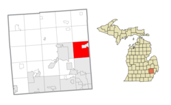
Shelby Charter Township, officially the Charter Township of Shelby, is a charter township located in Macomb County in the U.S. state of Michigan. The township is an affluent northern suburb of Detroit. As of the 2020 census, the population was 79,408, up from 73,804 in 2010. Shelby Charter Township is one of the fastest-growing communities in Metro Detroit.

<span class="mw-page-title-main">Sterling Heights, Michigan</span> City in Michigan, United States

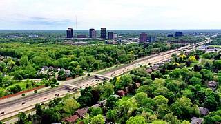
Sterling Heights is a city in Macomb County of the U.S. state of Michigan, and a suburb of Detroit. As of the 2020 census, the city had a total population of 134,346. It is the second largest suburb in Metro Detroit, and the fourth largest city in Michigan.

<span class="mw-page-title-main">Auburn Hills, Michigan</span> City in Michigan, United States

Auburn Hills is a city in Oakland County in the U.S. state of Michigan. A northern suburb of Detroit, Auburn Hills is located about 26 miles (42 km) north of downtown Detroit. As of the 2020 census, the city had a population of 24,360.

<span class="mw-page-title-main">Bloomfield Hills, Michigan</span> City in Michigan, United States

Bloomfield Hills is a city in Oakland County in the U.S. state of Michigan. A northern suburb of Detroit on the Woodward Corridor, Bloomfield Hills is located roughly 20 miles (32.2 km) northwest of downtown Detroit, and is surrounded on most sides by Bloomfield Township. As of the 2020 census, the city had a population of 4,460.

<span class="mw-page-title-main">Farmington Hills, Michigan</span> City in Michigan, United States

Farmington Hills is a city in Oakland County in the U.S. state of Michigan. A northwestern suburb of Detroit, Farmington Hills is located roughly 22 miles (35.4 km) from downtown Detroit. As of the 2020 census, the city's population was 83,986, making it the second-largest community in Oakland County.

<span class="mw-page-title-main">Lake Angelus, Michigan</span> City in Michigan, United States

Lake Angelus is a city in Oakland County in the U.S. state of Michigan. An affluent northern suburb of Detroit, Lake Angelus is located about 35 miles (56 km) north of downtown Detroit. With a population of 287 as of the 2020 census, Lake Angelus is the second-smallest city in Michigan, behind Omer; it also has one of the highest per capita incomes of any community in the state.

<span class="mw-page-title-main">Oakland Charter Township, Michigan</span> Charter township in Michigan, United States

The Charter Township of Oakland is a charter township on the north Oakland County outskirts of Metro Detroit, in the U.S. state of Michigan. It is colloquially referred to as "Oakland Township". The population was 20,067 at the 2020 census.

<span class="mw-page-title-main">Orion Township, Michigan</span> Charter township in Michigan, United States

Orion Charter Township is a charter township of Oakland County, Michigan, United States. The population was 38,206 as of the 2020 census.

<span class="mw-page-title-main">Rochester, Michigan</span> City in Michigan

Rochester is a city in Oakland County in the U.S. state of Michigan. The population was 12,711 at the 2010 census. It is a northern suburb in Metro Detroit located 20 miles north of the city of Detroit.

<span class="mw-page-title-main">Southfield, Michigan</span> City in Michigan, United States

Southfield is a city in Oakland County in the U.S. state of Michigan. An inner-ring suburb of Detroit, Southfield borders Detroit to the north, lying roughly 15 miles (24.1 km) northwest of downtown Detroit. As of the 2020 census, the city had a population of 76,618.

<span class="mw-page-title-main">Sylvan Lake, Michigan</span> City in Michigan, United States

Sylvan Lake is a city in Oakland County in the U.S. state of Michigan. A northern suburb of Detroit, Sylvan Lake is located roughly 26 miles (41.8 km) from downtown Detroit, and borders Pontiac to the east. As of the 2010 census, the city had a population of 1,720. With a land area of 0.51 square miles (1.32 km2), Sylvan Lake is the fourth-smallest city by land area in the state after Clarkston, Petersburg, and neighboring Keego Harbor.

<span class="mw-page-title-main">Troy, Michigan</span> City in Michigan, United States

Troy is a city in Oakland County in the U.S. state of Michigan. A northern suburb of Detroit, Troy is located about 22 miles (35 km) north of downtown Detroit. As of the 2020 census, the city had a population of 87,294, making Troy the largest community in Oakland County, and the 13th-most-populous municipality in the state.

<span class="mw-page-title-main">Clarkston, Michigan</span> City in Michigan, United States

Clarkston is a city in Oakland County, Michigan, United States. A northern suburb of Detroit, located about 34 mi (55 km) northwest of downtown Detroit, Clarkston is surrounded by Independence Township, but administered independently since its incorporation in 1992. At the 2020 census, the city had a population of 928. With a total land area of 0.44 square miles (1.14 km2), Clarkston is the smallest city by land area in the state of Michigan.

<span class="mw-page-title-main">Madison Heights, Michigan</span> City in Michigan, United States

Madison Heights is a city in Oakland County in the U.S. state of Michigan. An inner-ring suburb of Detroit, Madison Heights is located roughly 12 miles (19.3 km) north of downtown Detroit. As of the 2020 census, the city had a population of 28,468.

<span class="mw-page-title-main">Northville, Michigan</span> City in Michigan, United States

Northville is a city in Wayne and Oakland counties in the U.S. state of Michigan. A western suburb of Detroit, Northville is located roughly 27 miles (43.5 km) northwest of downtown Detroit, and 17 miles (27.4 km) northeast of Ann Arbor. As of the 2020 census, the city had a population of 6,119. It is entirely surrounded by Northville Township to the south, and Novi to the north.

<span class="mw-page-title-main">Bloomfield Township, Oakland County, Michigan</span> Charter township in Michigan, United States

Bloomfield Township is a charter township in Oakland County in the U.S. state of Michigan. A northern suburb of Detroit, Bloomfield Township is located roughly 20 miles (32 km) northwest of downtown Detroit. As of the 2020 census, the township had a population of 44,253.

<span class="mw-page-title-main">West Bloomfield Township, Michigan</span> Charter township in Michigan, United States

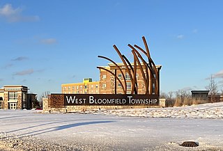
West Bloomfield Township is a charter township in Oakland County in the U.S. state of Michigan. A northwestern suburb of Detroit, West Bloomfield is located roughly 27 miles (43.5 km) from downtown Detroit. As of the 2020 census, the township had a population of 65,888.

<span class="mw-page-title-main">Washington Township, Macomb County, Michigan</span> Charter township in Michigan, United States

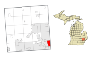
Washington Charter Township, located within Metro Detroit, is a charter township of Macomb County in the U.S. state of Michigan. The population was 28,165 at the 2020 census, up from 25,139 in 2010.

References

Notes

  1. "2020 U.S. Gazetteer Files". United States Census Bureau. Retrieved May 21, 2022.
  2. "U.S. Census website". United States Census Bureau . Retrieved 2008-01-31.
  3. "Rochester Hills". Geographic Names Information System . United States Geological Survey, United States Department of the Interior.
  4. "U.S. Census Bureau QuickFacts: Rochester Hills city, Michigan". Census.gov. Retrieved 2022-07-20.
  5. "Cities in Michigan by Population (2022)".
  6. "Welcome to Rochester Hills, MI". www.rochesterhills.org. Retrieved 2024-04-26.
  7. U.S. Geological Survey Geographic Names Information System: Stony Creek
  8. U.S. Geological Survey Geographic Names Information System: Yates, Michigan & GNIS in Google Map
  9. 1 2 "Native Americans of the Clinton River Watershed". Clinton River Watershed Council. Retrieved 23 November 2016.
  10. De Vaudreuil, M. "General Memoir Respecting the Indians between Lake Erie and the Mississippi, with Remarks upon Their Territory, Manners, Habits, Etc." In Documents Relative to the Colonial History of the State of New York, edited by E. B. O'Callaghan, MD, compiled by John Romeyn Brodhead, Esq, 887-90. Vol. IX. Albany, NY: Weed, Parsons and Company Printers, 1855.
  11. Duval, Roger. "Potawatomi Native Americans Fish and Hunt at Bald Eagle Lake". History of Bald Eagle Lake. Bald Eagle Lake Property Owner's Association. Retrieved 26 November 2016.
  12. Hull, William. "Treaty with the Ottawa, Etc., 1807". Indian Affairs: Laws and treaties. Oklahoma State University. Retrieved 25 November 2016.
  13. "Our Community's History." Rochester Hills, MI Official Website. https://www.rochesterhills.org/index.aspx?NID=267.
  14. "Saginaw Trail Historic Marker." Detroit: The History and Future of the Motor City. July 2009. http://www.detroit1701.org/.
  15. Romig 1986, p. 80.
  16. 1 2 "The Battle for Avon Township, Rochester and Rochester Hills, A Tale of Two Cities".
  17. "Michigan: 2010 Population and Housing Unit Counts 2010 Census of Population and Housing" (PDF). 2010 United States Census . United States Census Bureau. September 2012. p. 37 Michigan. Archived (PDF) from the original on 2012-10-19. Retrieved May 1, 2020.
  18. "Census of Population and Housing". Census.gov. Retrieved June 4, 2015.
  19. "U.S. Census website". United States Census Bureau.
  20. 1 2 "Search Results".
  21. Steele, Micki. "Asian-Americans settle in Metro Detroit enclaves." The Detroit News . April 19, 2011. Retrieved on September 9, 2013.
  22. "American FactFinder". United States Census Bureau . Retrieved 2012-11-25.
  23. "How Detroit's Oakland County suburbs voted in 2020 presidential election". 10 November 2020.
  24. https://www.michigan.gov/micrc/-/media/Project/Websites/MiCRC/District-Maps-by-County/MI_AllDistricts_byCounty_Oakland.pdf?rev=7343c1fcc5e24ef48f9e8d264ddd1817&hash=039744F56332FC662598D4A572A10A92 [ bare URL PDF ]
  25. "District Map Archived 2015-06-20 at WebCite " (Archive). Avondale School District. Retrieved on June 20, 2015.
  26. "JSD History" (Archive). Japanese School of Detroit. May 2, 2001. Retrieved on April 16, 2015. "(1999)  事務局移転(インターナショナル・アカデミー校→旧オークランド・シュタイナー校) "
  27. "Amy Frazier Enjoys Her Anonymity". Associated Press .
  28. "Jay Gibbons Stats". Baseball Almanac. Retrieved November 21, 2012.
  29. "Dita von Teese". IMDb .
  30. "Peter Vanderkaay".
  31. "Rochester's Famous Scientist". 23 October 2009.

Sources