Shannon, Illinois

Last updated

Shannon
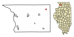
Carroll County Illinois Incorporated and Unincorporated areas Shannon Highlighted.svg
Location of Shannon in Carroll County, Illinois.
Illinois in United States (US48).svg
Location of Illinois in the United States
Coordinates: 42°09′07″N89°44′25″W / 42.15194°N 89.74028°W / 42.15194; -89.74028
CountryUnited States
StateIllinois
County Carroll
Township Cherry Grove
Government
  Village PresidentBonnie Foust
Area
[1]
  Total0.48 sq mi (1.25 km2)
  Land0.48 sq mi (1.25 km2)
  Water0.00 sq mi (0.00 km2)
Elevation
[2]
915 ft (279 m)
Population
 (2020)
  Total801
  Density1,661.83/sq mi (641.57/km2)
Time zone UTC-6 (CST)
  Summer (DST) UTC-5 (CDT)
ZIP Code(s)
61078
Area code 815
FIPS code 17-68991
Wikimedia CommonsShannon, Illinois
Website shannonillinois.com

Shannon is a village in Carroll County, Illinois, United States. The population was 801 at the 2020 census, up from 757 at the 2010 census.

Contents

History

Geography

Shannon is located at 42°9′7″N89°44′25″W / 42.15194°N 89.74028°W / 42.15194; -89.74028 (42.152039, -89.740211). [3]

According to the 2021 census gazetteer files, Shannon has a total area of 0.48 square miles (1.24 km2), all land. [4]

Demographics

Historical population
CensusPop.Note
1870 635
1880 71312.3%
1890 591−17.1%
1900 67814.7%
1910 633−6.6%
1920 6360.5%
1930 575−9.6%
1940 561−2.4%
1950 66819.1%
1960 76614.7%
1970 84810.7%
1980 93810.6%
1990 887−5.4%
2000 854−3.7%
2010 757−11.4%
2020 8015.8%
U.S. Decennial Census [5]

As of the 2020 census [6] there were 801 people, 326 households, and 212 families residing in the village. The population density was 1,661.83 inhabitants per square mile (641.64/km2). There were 367 housing units at an average density of 761.41 per square mile (293.98/km2). The racial makeup of the village was 94.01% White, 1.12% African American, 0.25% Native American, 0.12% Asian, 0.75% from other races, and 3.75% from two or more races. Hispanic or Latino of any race were 4.74% of the population.

There were 326 households, out of which 27.3% had children under the age of 18 living with them, 56.13% were married couples living together, 3.37% had a female householder with no husband present, and 34.97% were non-families. 32.82% of all households were made up of individuals, and 20.55% had someone living alone who was 65 years of age or older. The average household size was 2.89 and the average family size was 2.29.

The village's age distribution consisted of 20.7% under the age of 18, 8.2% from 18 to 24, 21% from 25 to 44, 23.6% from 45 to 64, and 26.4% who were 65 years of age or older. The median age was 45.0 years. For every 100 females, there were 96.6 males. For every 100 females age 18 and over, there were 98.3 males.

The median income for a household in the village was $52,500, and the median income for a family was $67,500. Males had a median income of $41,776 versus $30,893 for females. The per capita income for the village was $30,005. About 4.7% of families and 6.8% of the population were below the poverty line, including 13.0% of those under age 18 and 7.6% of those age 65 or over.

Religion

Shannon is home to three churches, Shannon Baptist, St. Wendelin's Catholic and Bethel United Methodist.

Notable person

Related Research Articles

<span class="mw-page-title-main">Loraine, Illinois</span> Village in Illinois, United States

Loraine is a village in Adams County, Illinois, United States. The population was 300 at the 2020 census.

<span class="mw-page-title-main">Nora, Illinois</span> Village in Illinois, United States

Nora is a village in Jo Daviess County, Illinois, United States. In 2020, the population was 107, down from 121 according to the 2010 census, which was up from 118 in 2000.

<span class="mw-page-title-main">St. Jacob, Illinois</span> Village in Illinois, United States

St. Jacob or Saint Jacob is a village in Madison County, Illinois, United States. The population was 1,358 at the 2020 census, up from 1,098 in 2010.

<span class="mw-page-title-main">Kinderhook, Illinois</span> Village in Illinois, United States

Kinderhook is a village in Pike County, Illinois, United States. The population was 216 at the 2010 census, a decline from 249 in 2000.

<span class="mw-page-title-main">Ellis Grove, Illinois</span> Village in Illinois, United States

Ellis Grove is a village in Randolph County, Illinois, United States. The population was 328 at the 2020 census.

<span class="mw-page-title-main">Pearl City, Illinois</span> Village in Illinois, United States

Pearl City is an incorporated village in Stephenson County, Illinois, with a population of 838 at the 2010 census, up from 780 in 2000.

<span class="mw-page-title-main">New Milford, Illinois</span> Village in Illinois, United States

New Milford is a village in Winnebago County, Illinois, United States on the south bank of the Kishwaukee River overlooking the south side of Rockford. It is part of the Rockford, Illinois Metropolitan Statistical Area. The population was 697 at the 2010 census, up from 541 in 2000.

<span class="mw-page-title-main">Whiting, Iowa</span> City in Iowa, United States

Whiting is a city in Monona County, Iowa, United States. The population was 745 at the time of the 2020 census.

<span class="mw-page-title-main">Grand Isle, Maine</span> Town in the state of Maine, United States

Grand Isle is a town in Aroostook County, Maine, United States. The population was 366 at the 2020 census. The village of Grand Isle is in the northwestern part of the town.

<span class="mw-page-title-main">Shoreham, Michigan</span> Village in Michigan, United States

Shoreham is a village in Berrien County in the U.S. state of Michigan. The population was 844 at the 2020 census. The village is located within St. Joseph Charter Township on the shore of Lake Michigan, just south of the City of St. Joseph.

<span class="mw-page-title-main">Lambert, Missouri</span> Inactive Village in Missouri, United States

Lambert is an inactive village in Scott County, Missouri, United States. The population was 48 at the 2020 census.

<span class="mw-page-title-main">Rockdale, Wisconsin</span> Village in Wisconsin, United States

Rockdale is a village in Dane County, Wisconsin, United States. The population was 207 at the 2020 census, making it the smallest incorporated municipality in Dane County. The village is split in half by the Koshkonong Creek. It is part of the Madison Metropolitan Statistical Area.

<span class="mw-page-title-main">Browntown, Wisconsin</span> Village in Wisconsin, United States

Browntown is a village in Green County, Wisconsin, United States. The population was 280 at the 2010 census.

<span class="mw-page-title-main">South Wayne, Wisconsin</span> Village in Wisconsin, United States

South Wayne is a village in Lafayette County, Wisconsin, United States. The population was 446 at the 2020 census.

<span class="mw-page-title-main">Bonduel, Wisconsin</span> Village in Wisconsin, United States

Bonduel is a village in Shawano County, Wisconsin, United States. The population was 1,417 at the 2020 census, and 1,478 at the 2010 census.

<span class="mw-page-title-main">Tigerton, Wisconsin</span> Village in Wisconsin, United States

Tigerton is a village in Shawano County, Wisconsin, United States. The population was 741 at the 2010 census.

<span class="mw-page-title-main">Kingston, Wisconsin</span> Village in Wisconsin, United States

Kingston is a village in Green Lake County, Wisconsin, United States. The population was 326 at the 2010 census. The village is located within the Town of Kingston. The unincorporated community of Dalton, Wisconsin is near Kingston.

<span class="mw-page-title-main">Ridgeway, Wisconsin</span> Village in Wisconsin, United States

Ridgeway is a village in Iowa County, Wisconsin, United States. The population was 624 at the 2020 census. The village is adjacent to the Town of Ridgeway. It is part of the Madison Metropolitan Statistical Area.

<span class="mw-page-title-main">Clinton (village), Rock County, Wisconsin</span> Village in Wisconsin, United States

Clinton is a village in Rock County, Wisconsin, United States. The population was 2,221 in the 2020 census. The village is located within the town of Clinton. The Norwegian-American Jefferson Prairie Settlement was located near the village.

<span class="mw-page-title-main">Lohrville, Wisconsin</span> Village in Wisconsin, United States

Lohrville is a village in Waushara County, Wisconsin, United States. The population was 402 at the 2010 census.

References

  1. "2020 U.S. Gazetteer Files". United States Census Bureau. Retrieved March 15, 2022.
  2. "USGS detail on Newtown" . Retrieved October 21, 2007.
  3. "US Gazetteer files: 2010, 2000, and 1990". United States Census Bureau. February 12, 2011. Retrieved April 23, 2011.
  4. Bureau, US Census. "Gazetteer Files". Census.gov. Retrieved June 29, 2022.{{cite web}}: |last= has generic name (help)
  5. "Census of Population and Housing". Census.gov. Retrieved June 4, 2015.
  6. "Explore Census Data". data.census.gov. Retrieved June 28, 2022.
  7. 'Illinois Blue Book 1931-1932,' Biographical Sketch of Alfred S. Babb, pg. 236-237