Show Low, Arizona

Last updated

Show Low
ShowLow AZ from northwest.jpg
Flag of Show Low, Arizona.svg
Motto: 
"Named By The Turn Of A Card"
Navajo County Arizona Incorporated and Unincorporated areas Show Low Highlighted 0466470.svg
Location of Show Low in Navajo County, Arizona
Usa edcp location map.svg
Red pog.svg
Show Low
Location in United States
Coordinates: 34°14′37″N110°02′53″W / 34.24361°N 110.04806°W / 34.24361; -110.04806
CountryUnited States
State Arizona
County Navajo
Founded1870
Incorporated 1953
Government
  Type Council–Manager
  BodyShow Low City Council
  MayorJohn Leech[ citation needed ]
Area
[1]
  Total65.98 sq mi (170.88 km2)
  Land65.50 sq mi (169.66 km2)
  Water0.47 sq mi (1.23 km2)
Elevation
[2]
6,349 ft (1,935 m)
Population
 (2020)
  Total11,732
  Density179.10/sq mi (69.15/km2)
Time zone UTC−7 (Mountain)
  Summer (DST) UTC−7 (no DST/PDT)
ZIP Codes
85901, 85902, 85911
Area code 928
FIPS code 04-66470
GNIS ID(s)2411895 [2]
Major airport Show Low Regional Airport
U.S. Highways US 60.svg
State Routes Arizona 77.svg Arizona 260.svg
Website www.ci.show-low.az.us OOjs UI icon edit-ltr-progressive.svg
U.S. Decennial Census [3]

Show Low is a city in Navajo County, Arizona. It lies on the Mogollon Rim in east central Arizona, at an elevation of 6,345 feet (1,934 m). The city was established in 1870 and incorporated in 1953. According to the 2010 census, the population of the city was 10,660. [4]

Contents

Name and history

According to a legend, the city's unusual name [5] resulted from a marathon poker game between Corydon E. Cooley and Marion Clark. The two men were equal partners in a 100,000-acre (400 km2) ranch; however, the partners determined that there was not enough room for both of them in their settlement, and agreed to settle the issue over a game of "Seven Up" (with the winner taking the ranch and the loser leaving). [6] After the game seemed to have no winner in sight, Clark said, "If you can show low, you win." In response, Cooley turned up the deuce of clubs (the lowest possible card) and replied, "Show low it is." [7] As a tribute to the legend, Show Low's main street is named "Deuce of Clubs" in remembrance. [5]

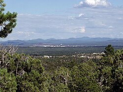
In 2002, a large forest fire, the Rodeo–Chediski Fire, threatened the city and forced an evacuation. The fire was extinguished less than a half mile from the city's border, and Show Low was completely spared. The city is near extensive forests, and is a popular recreational area.

Geography

According to the United States Census Bureau, the city has a total area of 27.9 square miles (72 km2), of which 27.9 square miles (72 km2) is land and 0.1 square miles (0.26 km2) (0.25%) is water.

Show Low is located roughly 270 miles from both Why and Nothing. [8]

Climate

Winters in Show Low bring highs between 45 °F (7 °C) and 55 °F (13 °C), with lows usually below freezing between November and March, averaging in the 20s December through February, and in the low 30s for November and March.

In the summer, highs in Show Low average approximately 85 °F (29 °C), with an occasional day above 90 °F (32 °C) not uncommon for the city. As the sun sets in the summertime, temperatures plummet dramatically, sometimes upwards of 30 °F (17 °C). This nightly temperature swing results in summertime lows typically ranging between 50 °F (10 °C) and 60 °F (16 °C).

Show Low has reached below-freezing temperatures every month at least once in its history except July and August, where temperatures have only reached 38 °F (3 °C) and 37 °F (3 °C) respectively.

Show Low has twice reached 100 °F (38 °C), its record high temperature: once on May 31, 1969, and again on July 14, 2003. Show Low's record low temperature of -25 °F (-32 °C) was set on January 8, 1971.

Show Low averages about 15.7 inches (400 mm) of rain per year.

The city has a Mediterranean climate (Köppen Csa). Unlike most locations with this climate, but similar to most of Arizona, the rainfall maximum is in the summer due to the North American Monsoon.

Climate data for Show Low Airport, Arizona (1991–2020 normals, extremes 1984–present)
MonthJanFebMarAprMayJunJulAugSepOctNovDecYear
Record high °F (°C)69
(21)
71
(22)
80
(27)
84
(29)
94
(34)
98
(37)
100
(38)
97
(36)
93
(34)
85
(29)
76
(24)
68
(20)
100
(38)
Mean maximum °F (°C)59.4
(15.2)
63.9
(17.7)
70.9
(21.6)
77.2
(25.1)
85.5
(29.7)
93.3
(34.1)
94.5
(34.7)
90.9
(32.7)
86.9
(30.5)
79.9
(26.6)
70.0
(21.1)
61.4
(16.3)
95.5
(35.3)
Mean daily maximum °F (°C)46.0
(7.8)
51.0
(10.6)
58.0
(14.4)
64.9
(18.3)
73.6
(23.1)
83.9
(28.8)
85.3
(29.6)
82.8
(28.2)
78.3
(25.7)
68.1
(20.1)
56.4
(13.6)
45.8
(7.7)
66.2
(19.0)
Daily mean °F (°C)34.8
(1.6)
38.9
(3.8)
44.7
(7.1)
50.9
(10.5)
59.0
(15.0)
68.8
(20.4)
72.2
(22.3)
70.2
(21.2)
65.1
(18.4)
54.3
(12.4)
43.7
(6.5)
34.6
(1.4)
53.1
(11.7)
Mean daily minimum °F (°C)23.6
(−4.7)
26.8
(−2.9)
31.3
(−0.4)
36.8
(2.7)
44.5
(6.9)
53.7
(12.1)
59.2
(15.1)
57.7
(14.3)
52.0
(11.1)
40.6
(4.8)
31.0
(−0.6)
23.4
(−4.8)
40.1
(4.5)
Mean minimum °F (°C)4.8
(−15.1)
10.9
(−11.7)
17.1
(−8.3)
22.9
(−5.1)
31.3
(−0.4)
41.6
(5.3)
52.2
(11.2)
50.6
(10.3)
39.4
(4.1)
24.4
(−4.2)
14.0
(−10.0)
4.9
(−15.1)
1.6
(−16.9)
Record low °F (°C)−14
(−26)
−11
(−24)
5
(−15)
12
(−11)
23
(−5)
33
(1)
40
(4)
38
(3)
29
(−2)
6
(−14)
1
(−17)
−22
(−30)
−22
(−30)
Average precipitation inches (mm)1.35
(34)
1.16
(29)
0.91
(23)
0.57
(14)
0.62
(16)
0.42
(11)
2.35
(60)
2.97
(75)
1.44
(37)
1.35
(34)
1.19
(30)
1.37
(35)
15.70
(399)
Average snowfall inches (cm)4.0
(10)
3.8
(9.7)
2.3
(5.8)
1.6
(4.1)
0.0
(0.0)
0.0
(0.0)
0.0
(0.0)
0.0
(0.0)
0.0
(0.0)
0.4
(1.0)
1.9
(4.8)
5.4
(14)
19.4
(49)
Average precipitation days (≥ 0.01 in)6.96.55.74.14.32.912.914.97.45.64.76.582.4
Average snowy days (≥ 0.1 in)2.01.60.90.50.00.00.00.00.00.20.91.77.8
Source: NOAA [9] [10]

Demographics

Historical population
CensusPop.Note
1910 201
1920 25828.4%
1930 31522.1%
1960 1,625
1970 2,12931.0%
1980 4,298101.9%
1990 5,01916.8%
2000 7,69553.3%
2010 10,66038.5%
2020 11,73210.1%
U.S. Decennial Census [3] [11]

As of the census [12] of 2000, there were 7,695 people, 2,885 households, and 2,117 families residing in the city. The population density was 859 inhabitants per square mile (332/km2). There were 7186 housing units at an average density of 155.7 per square mile (60.1/km2). The racial makeup of the city was 90.3% White, 0.4% Black or African American, 3.2% Native American, 0.5% Asian, 0.1% Pacific Islander, 3.4% from other races, and 2.2% from two or more races. 9.4% of the population were Hispanic or Latino of any race.

There were 2,885 households, out of which 34.8% had children under the age of 18 living with them, 58.2% were married couples living together, 11.1% had a female householder with no husband present, and 26.6% were non-families. 21.9% of all households were made up of individuals, and 9.5% had someone living alone who was 65 years of age or older. The average household size was 2.62 and the average family size was 3.04.

In the city, the population was spread out, with 29.2% under the age of 18, 7.4% from 18 to 24, 24.9% from 25 to 44, 23.5% from 45 to 64, and 15.0% who were 65 years of age or older. The median age was 37 years. For every 100 females, there were 95.1 males. For every 100 females age 18 and over, there were 88.5 males.

The median income for a household in the city was $32,356, and the median income for a family was $36,397. Males had a median income of $28,882 versus $24,590 for females. The per capita income for the city was $15,536. About 11.7% of families and 15.0% of the population were below the poverty line, including 23.6% of those under age 18 and 6.0% of those age 65 or over.

Transportation

Show Low Regional Airport (IATA: SOW, ICAO: KSOW) provides passenger airline service through Southern Airways Express to Phoenix. The airport maintains a single passenger terminal for this purpose. The airport is also commonly used for air cargo, air-taxi, and as a fixed-base operator for general aviation.

The city also maintains a minor public transportation operation in conjunction with neighboring Pinetop-Lakeside. Two shuttles service multiple retail, high-traffic, and government offices and also the airport and nearby Hon-Dah casino (57 stops in all). The city also operates the White Mountain Connection, which serves Pinetop-Lakeside, Taylor, Snowflake, and Holbrook. [13] Mountain Valley Shuttle provides a daily shuttle from Show Low to Phoenix. [14]

Education

Almost all of the city is a part of the Show Low Unified School District. A portion of the city is within the boundaries of the Blue Ridge Unified School District.

Schools that serve the SLUSD portion of the city include Linden Elementary, Nikolaus Homestead Elementary, Whipple Ranch Elementary, White Mountain Institute, Show Low Junior High School, and Show Low High School.

Additionally St. Anthony School (K-8) of the Roman Catholic Diocese of Gallup is in Show Low. Circa 2009 it covered to grade 4. As of that time it was adding the 5th grade the following year and adding another grade each year until grade 8. [15]

Show Low is home to one of Northland Pioneer College's four regional campuses, the White Mountain Campus.

Economy

Top employers

According to the city's 2014 Comprehensive Annual Financial Report, [16] the top employers in the city are:

#Employer# of Employees
1Summit Healthcare Regional Medical Center900
2 Walmart 490
3 Show Low Unified School District 300
4 Cellular One 187
5City of Show Low153
6 The Home Depot 150
7 Citizens Telecommunications Company of the White Mountains 125
8 Northland Pioneer College 110
9 Lowe's 108
10Tate's Auto Group70

Notable people

Nearest cities and towns

Related Research Articles

<span class="mw-page-title-main">Navajo County, Arizona</span> County in Arizona, United States

Navajo County is in the northern part of the U.S. state of Arizona. As of the 2020 census, its population was 106,717. The county seat is Holbrook.

<span class="mw-page-title-main">McNary, Arizona</span> CDP in Apache and Navajo Counties, Arizona

McNary is a census-designated place (CDP) in Apache and Navajo counties in the U.S. state of Arizona, on the Fort Apache Indian Reservation. The population was 528 at the 2010 census.

<span class="mw-page-title-main">Teec Nos Pos, Arizona</span> Census-designated place in Arizona, United States

Teec Nos Pos is a census-designated place (CDP) in Apache County, Arizona, United States. The population was 507 at the 2020 census. It is the western terminus of U.S. Route 64.

<span class="mw-page-title-main">Williams, Arizona</span> City in Coconino County, Arizona

Williams is a city in Coconino County, Arizona, United States, located west of Flagstaff. Its population was 3,023 at the 2010 census. It lies on the routes of Historic Route 66 and Interstate 40. It is also the southern terminus of the Grand Canyon Railway, which takes visitors to Grand Canyon Village.

<span class="mw-page-title-main">Safford, Arizona</span> City in Arizona, United States

Safford is a city in Graham County, Arizona, United States. According to the 2020 Census, the population of the city is 10,129. The city is the county seat of Graham County.

<span class="mw-page-title-main">Avondale, Arizona</span> City in Arizona, United States

Avondale is a city in Maricopa County, Arizona, United States, adjacent to Phoenix. As of the 2020 census, the population of the city was 89,334, up from 76,238 in 2010 and 35,883 in 2000.

<span class="mw-page-title-main">Cave Creek, Arizona</span> Town in Maricopa County, Arizona

Cave Creek is a town in Maricopa County, Arizona, United States. It is part of the Phoenix metropolitan area. As of the 2020 census, the population of the town was 4,892.

<span class="mw-page-title-main">Pinetop-Lakeside, Arizona</span> Town in Navajo County, Arizona

Pinetop–Lakeside is a town in Navajo County, Arizona, United States. According to 2020 census, the population of the town is 4,557. It was founded in 1984 when the neighboring towns of Pinetop and Lakeside merged.

<span class="mw-page-title-main">Snowflake, Arizona</span> Town in Navajo County, Arizona, U.S.

Snowflake is a town in Navajo County, Arizona, United States. It was founded in 1878 by Erastus Snow and William Jordan Flake, Mormon pioneers. Snowflake is 25 miles (40 km) south of Interstate 40 via Highway 77. The Apache Railway provides freight service.

<span class="mw-page-title-main">Arizona City, Arizona</span> CDP in Pinal County, Arizona

Arizona City is an unincorporated census-designated place (CDP) in southwestern Pinal County, Arizona, United States. It is located near the junction of Interstate 8 and Interstate 10 at the midpoint between Phoenix and Tucson, approximately 60 miles (97 km) from the downtown of both cities. The population was 10,475 as of the 2010 U.S. Census. It is estimated to be approximately 11,030 as of a 2017 U.S. Census estimate. Arizona City is a rural, primarily residential community that features a 48-acre man-made lake which has an HOA and is private to residents of surrounding homes only. These attributes make the community a popular snowbird destination, with the population increasing by as much as 5,000 people in the winter months to reach the census figure of 11,030. Most recently after the last Census, many full-time residents have relocated to the unincorporate town.

<span class="mw-page-title-main">Coolidge, Arizona</span> City in Arizona, United States

Coolidge is a city in Pinal County, Arizona, United States. According to the 2020 census, the city's population is 13,218.

<span class="mw-page-title-main">Cottonwood, Arizona</span> City in the United States

Cottonwood is a city in Yavapai County, Arizona, United States. According to the 2010 census, the population of the city is 11,265.

<span class="mw-page-title-main">Alton, Kansas</span> City in Osborne County, Kansas

Alton is a city in Osborne County, Kansas, United States. As of the 2020 census, the population of the city was 100.

<span class="mw-page-title-main">Whitesburg, Kentucky</span> City in Kentucky, United States

Whitesburg is a home rule-class city in and the county seat of Letcher County, Kentucky, United States. The population was 2,139 at the 2010 census and an estimated 1,875 in 2018. It was named for John D. White, a state politician.

<span class="mw-page-title-main">Tower, Minnesota</span> City in Minnesota, United States

Tower is a city located in Saint Louis County, Minnesota, United States. As of the 2020 census, the city had a total population of 430. State Highways 1, 169, and 135 are three of the main routes in Tower. Tower is located on the southern shore of Lake Vermilion.

<span class="mw-page-title-main">Coquille, Oregon</span> City in Oregon, United States

Coquille is a city in, and the county seat of, Coos County, Oregon, United States. The population was 4,015 at the 2020 census. The primary economic base is the timber industry. The city derives its name from the Coquille Native American tribe.

<span class="mw-page-title-main">Powers, Oregon</span> City in Oregon, United States

Powers is a city in Coos County, Oregon, United States. The population was 689 at the 2010 census.

<span class="mw-page-title-main">Forest Lakes, Arizona</span> Unincorporated community in the state of Arizona, United States

Forest Lakes is a small unincorporated community in Coconino County in the northern part of the U.S. state of Arizona. It is located on the edge of the Mogollon Rim and is in close proximity to several recreational lakes within the Apache-Sitgreaves National Forest, and is named for such.

Hondah is a census-designated place (CDP) in Navajo County, Arizona, United States, on the Fort Apache Indian Reservation. The population was 812 at the 2010 census.

Lake of the Woods is a census-designated place (CDP) in Navajo County, Arizona, United States, adjacent to the town of Pinetop-Lakeside. The population was 4,094 at the 2010 census.

References

Schools, Show Low Unified School District Retrieved July 24, 2009

  1. "2020 U.S. Gazetteer Files". United States Census Bureau. Retrieved October 29, 2021.
  2. 1 2 U.S. Geological Survey Geographic Names Information System: Show Low, Arizona
  3. 1 2 "Census of Population and Housing". Census.gov. Retrieved June 4, 2016.
  4. "U.S. Census website". United States Census Bureau . Retrieved August 5, 2014.
  5. 1 2 Gallant, Frank K. (2012). A Place Called Peculiar: Stories about Unusual American Place-Names. Courier Dover Publications. p. 15. ISBN   9780486483603.
  6. "Economic Development". Show Low, AZ - Official Website showlowaz.gov. Retrieved October 18, 2022.
  7. M.r. Montgomery (March 18, 1996). Many Rivers to Cross: Of Good Running Water, Native Trout, and the Remains Of Wilderness. Simon and Schuster. p. 60. ISBN   978-0-684-81829-0.
  8. "The Nine Worst Arizona Town Names".
  9. "NOWData - NOAA Online Weather Data". National Oceanic and Atmospheric Administration . Retrieved August 15, 2022.
  10. "U.S. Climate Normals Quick Access – Station: Show Low AP, AZ". National Oceanic and Atmospheric Administration. Retrieved January 28, 2023.
  11. "United States Census Bureau QuickFacts". United States Census Bureau. Retrieved February 24, 2022.
  12. "U.S. Census website". United States Census Bureau . Retrieved January 31, 2008.
  13. "White Mountain Connection | Show Low, AZ - Official Website" . Retrieved January 22, 2020.
  14. "Mountain Valley Shuttle" . Retrieved January 22, 2020.
  15. "Home". St. Anthony School, Show Low. October 8, 2009. Archived from the original on October 8, 2009. Retrieved January 13, 2022.
  16. "Comprehensive Annual Financial Report". City of Show Low, Arizona. 2014.