Tamborine Mountain road network

Last updated

The Tamborine Mountain road network is a group of roads that provide access to the mountain community from various lowland localities. The network ensures continuity of access in times of flooding or other natural disasters, and during planned maintenance activities. The locality of Tamborine Mountain includes a plateau [1] that hosts a substantial residential community plus many tourism accommodation and activity venues. [2]

Contents

Located to the south-west of Brisbane and north-west of the Gold Coast, Tamborine Mountain is also a popular day-trip destination. [2] Most traffic from Brisbane travels through Tamborine village, [3] in the locality of Tamborine to the north-west of the mountain, while most Gold Coast traffic travels through Mount Nathan (to the south-east) or Wongawallan [4] (to the north-east).

Roads in the network

The following roads are considered to be part of the network:

Beaudesert–Beenleigh Road

Beaudesert–Beenleigh Road

Australian state route 92.svg

LocationBeaudesert–Nerang Road, Tabragalba to Beenleigh Connection Road, Beenleigh
Length35.5 km (22.1 mi)
Route number 92

Beaudesert–Beenleigh Road passes through Tamborine village, bringing traffic from the Mount Lindesay Highway to the south-west and from the Pacific Motorway to the north-east. [5] Some of the traffic on this road then travels on Tamborine Mountain Road to reach Tamborine Mountain.

Beaudesert–Nerang Road

Beaudesert–Nerang Road

Australian state route 90.svg

LocationMount Lindesay Highway, Beaudesert to Southport–Nerang Road, Nerang
Length58.9 km (36.6 mi)
Route number 90

Beaudesert–Nerang Road passes through Canungra to the south and Clagiraba to the south-east, providing access to roads from those localities to Tamborine Mountain. [6]

Tamborine Mountain Road

Tamborine Mountain Road

Australian state route 95.svg

LocationBeaudesert–Beenleign Road, Tamborine to Beaudesert–Nerang Road, Canungra
Length24.1 km (15.0 mi)
Route number 95

Tamborine Mountain Road runs from Tamborine village in the north-west to Tamborine Mountain and continues south to Canungra. [7] It carries most of the rraffic from Brisbane to Tamborine Mountain.

Tamborine–Nerang Road

Tamborine–Nerang Road

LocationTamborine Mountain Road to Beaudesert–Nerang Road, Clagiraba
Length10.9 km (6.8 mi)

Tamborine–Nerang Road is a state-controlled district road (number 2050) rated as a local road of regional significance (LRRS). [8] [9] It runs from Tamborine Mountain Road in Tamborine Mountain to Beaudesert–Nerang Road in Clagiraba, a distance of 10.9 kilometres (6.8 mi) by a circuitous route to the east. [10] It is known in parts by each of the following local names:

Petition for improvements

In October 2021 a petition requesting improvements to Tamborine Mountain roads was presented to the Queensland Parliament. Particular mention was made of the poor condition of Golf Course Road, Guanaba Road and Henri Robert Drive, all components of this road. Also mentioned was Main Western Road, the component of Tamborine Mountain Road used to access this road. [11]

Tamborine–Oxenford Road

Tamborine–Oxenford Road

Australian state route 95.svg

LocationTamborine Mountain Road to Pacific Motorway, Oxenford
Length22.2 km (13.8 mi)
Route number 95

Tamborine–Oxenford Road is a state-controlled district road (number 206) rated as a local road of regional significance (LRRS). [8] [9] It runs from Tamborine Mountain Road in Tamborine Mountain to the Pacific Motorway in Oxenford, a distance of 22.2 kilometres (13.8 mi) by a circuitous route to the north-east. [12] It is known in parts by each of the following local names:

Upgrade project

A project to upgrade the Howard Creek Causeway, at a cost of $10 million, entered the construction phase in October 2021. [13]

Waterford–Tamborine Road

Waterford–Tamborine Road

Australian state route 95.svg

LocationWaterford to Tamborine village
Length25.0 km (15.5 mi)
Route number 95

Waterford–Tamborine Road is a state-controlled district road (number 207) rated as a local road of regional significance (LRRS). [8] [9] It runs from Brisbane–Beenleigh Road [lower-alpha 1] (Albert Street) in Waterford to Tamborine village, a distance of 25.0 kilometres (15.5 mi) by a fairly direct route to the south. [14] Much of the traffic from this road then travels on Tamborine Mountain Road to reach Tamborine Mountain. The road is known for a short distance in Waterford as Nerang Street.

Upgrade projects

Five upgrade projects are in planning, progress or recently completed for this road. [15] They are:

  • * Lane duplication from North Street to Anzac Avenue was completed in late 2021.
  • * Construction of improvements to the intersection with Brisbane-Beenleigh Road was started in May 2022.
  • * Construction and installation of traffic signals at the intersection with Easterly Street was expected to start in September 2022.
  • * Investigation of a possible upgrade between Stegemann Road and Dairy Creek Road has been carried out, and design is expected to proceed, but there is no funding for construction.
  • * Planning for possible future upgrades along the road is continuing.

See also

Notes

  1. Brisbane-Beenleigh Road is a state-controlled district road (number 204) rated as a local road of regional significance (LRRS). [8] [9] It is known locally as Kingston Road, Albert Street and Logan River Road. [14]

Related Research Articles

<span class="mw-page-title-main">Pacific Motorway (Brisbane–Brunswick Heads)</span> Motorway in New South Wales and Queensland

The Pacific Motorway is a motorway in Australia between Brisbane, Queensland, and Brunswick Heads, New South Wales, through the New South Wales–Queensland border at Tweed Heads.

<span class="mw-page-title-main">Canungra, Queensland</span> Town in Queensland, Australia

Canungra is a rural town and locality in the Scenic Rim Region, Queensland, Australia. In the 2016 census, the locality of Canungra had a population of 1,229 people.

<span class="mw-page-title-main">Beechmont, Queensland</span> Suburb of Scenic Rim Region, Queensland, Australia

Beechmont is a rural town and locality in the Scenic Rim Region, Queensland, Australia. In the 2016 census, the locality of Beechmont had a population of 842 people.

<span class="mw-page-title-main">Clagiraba, Queensland</span> Suburb of Gold Coast, Queensland, Australia

Clagiraba is a rural locality in the City of Gold Coast, Queensland, Australia. In the 2016 census, Clagiraba had a population of 601 people.

<span class="mw-page-title-main">Cedar Creek, Queensland (Logan & Gold Coast)</span> Suburb of City of Gold Coast, Queensland, Australia

Cedar Creek is a locality split between City of Gold Coast and Logan City in Queensland, Australia. In the 2016 census Cedar Creek had a population of 838 people.

<span class="mw-page-title-main">Nindooinbah, Queensland</span> Suburb of Scenic Rim Region, Queensland, Australia

Nindooinbah is a rural locality in the Scenic Rim Region, Queensland, Australia. In the 2016 census Nindooinbah had a population of 80 people.

<span class="mw-page-title-main">Wonglepong, Queensland</span> Suburb of Scenic Rim Region, Queensland, Australia

Wonglepong is a rural locality in the Scenic Rim Region, Queensland, Australia. In the 2016 census, Wonglepong had a population of 341 people.

<span class="mw-page-title-main">Shire of Beenleigh</span>

The Shire of Beenleigh is a former local government area in the south-east of Queensland, Australia, centred on the town of Beenleigh. It existed from 1879 to 1949.

<span class="mw-page-title-main">Shire of Cleveland</span>

The Shire of Cleveland is a former local government area in the south-east of Queensland, Australia, centred on the town of Cleveland beside Moreton Bay.

The Shire of Waterford is a former local government area in the south-east of Queensland, Australia, centred on the town of Waterford. It existed between 1879 and 1948.

<span class="mw-page-title-main">Shire of Coomera</span>

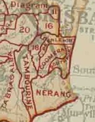
The Shire of Coomera was a local government area in South East Queensland, Australia. The shire, administered from Coomera, existed as a local government entity from 1879 until 1949.

<span class="mw-page-title-main">Shire of Nerang</span>

The Shire of Nerang was a local government area in South East Queensland, Australia. The shire existed as a local government entity from 1879 until 1949.

The Shire of Tamborine was a local government area in South East Queensland, Australia, centred on the village of Tamborine. It existed from 1890 to 1949.

<span class="mw-page-title-main">Town of Coolangatta</span>

The Town of Coolangatta was a local government area in South East Queensland, Australia, centred on Coolangatta. It existed from 1914 to 1949.

The Town of South Coast was a local government area in South East Queensland, Australia.

Witheren is a rural locality in the Scenic Rim Region, Queensland, Australia. In the 2016 census Witheren had a population of 496 people.

<span class="mw-page-title-main">Tamborine, Queensland</span> Suburb of Logan City, Queensland, Australia

Tamborine is a rural town in the Scenic Rim Region and a locality split between the Scenic Rim Region and the City of Logan in Queensland, Australia. In the 2016 census, the locality of Tamborine had a population of 3,950 people.

<span class="mw-page-title-main">Tamborine Mountain Road</span> Historic site in Queensland, Australia

Tamborine Mountain Road is a continuous 24.1 kilometres (15.0 mi) road route in the Scenic Rim local government area of Queensland, Australia. Part of the route is designated as State Route 95. It is a state-controlled district road, rated as a local road of regional significance (LRRS).

Beaudesert–Nerang Road is a major inter-regional arterial road that connects the township of Beaudesert with the Gold Coast via Canungra. The road commences in Nerang on the western edge of the Gold Coast and travels west through the Gold Coast hinterland and terminates in central Beaudesert at the intersection of Mount Lindesay Highway.

Beaudesert–Beenleigh Road is a continuous 35.5 kilometres (22.1 mi) road route in the Scenic Rim and Logan City regions of Queensland, Australia. Part of the road is signed as State Route 90 and the rest as State Route 92. Beaudesert–Beenleigh Road is a state-controlled road, part district and part regional.

References

  1. "Tamborine Mountain – plateau in the Scenic Rim Region (entry 33236)". Queensland Place Names. Queensland Government . Retrieved 3 March 2022.
  2. 1 2 "Tamborine Mountain". Scenic Rim Regional Council. Archived from the original on 6 October 2011. Retrieved 27 June 2011.
  3. Google (13 September 2022). "Brisbane to Tamborine Mountain" (Map). Google Maps . Google. Retrieved 13 September 2022.
  4. Google (13 September 2022). "Gold Coast to Tamborine Mountain" (Map). Google Maps . Google. Retrieved 13 September 2022.
  5. Google (21 February 2022). "Tabragalba to Beenleigh" (Map). Google Maps . Google. Retrieved 21 February 2022.
  6. "Beaudesert - Nerang Road". Google Maps. Retrieved 20 June 2018.
  7. Google (20 September 2022). "Tamborine to Canungra via Tamborine Mountain" (Map). Google Maps . Google. Retrieved 20 September 2022.
  8. 1 2 3 4 The State Road Network of Queensland (PDF) (Map). Queensland Government ©State of Queensland [CC BY 4.0]. 30 June 2019. Archived (PDF) from the original on 30 March 2014. Retrieved 29 November 2021.
  9. 1 2 3 4 "South Coast district map" (PDF). Department of Transport and Main Roads ©State of Queensland [CC BY 4.0]. 2020. Retrieved 17 September 2022.
  10. Google (20 September 2022). "Tamborine Mountain to Clagiraba" (Map). Google Maps . Google. Retrieved 20 September 2022.
  11. "Improvements to Tamborine Mountain Roads". Queensland Parliament. 12 October 2021. Retrieved 22 September 2022.
  12. Google (20 September 2022). "Tamborine Mountain to Oxenford" (Map). Google Maps . Google. Retrieved 20 September 2022.
  13. "Tamborine-Oxenford Road, Howard Creek Causeway, upgrade flood immunity". Queensland Government. 15 August 2022. Retrieved 20 September 2022.
  14. 1 2 Google (20 September 2022). "Waterford to Tamborine village" (Map). Google Maps . Google. Retrieved 20 September 2022.
  15. "Waterford-Tamborine Road". Queensland Government. 18 August 2022. Retrieved 20 September 2022.