Transportation in Greater Los Angeles

Last updated
Los Angeles Union Station, hub for LACMTA metro lines and buses, Metrolink and Amtrak trains, and the Hollywood Freeway, one of Los Angeles' major thoroughfares Los Angeles Union Station.jpg
Los Angeles Union Station, hub for LACMTA metro lines and buses, Metrolink and Amtrak trains, and the Hollywood Freeway, one of Los Angeles' major thoroughfares

Greater Los Angeles has a complex multimodal transportation infrastructure, which serves as a regional, national and international hub for passenger and freight traffic. The transportation system of Greater Los Angeles includes the United States' largest port complex, seven commuter rail lines, Amtrak service, a subway system within the city of Los Angeles, and numerous highways. Los Angeles is integrated into the Interstate Highway System by Interstate 5, Interstate 10, and Interstate 15, along with numerous auxiliary highways and state routes. Bus service is also included locally within the area by numerous local government agencies. Subways and light commuter rail lines are present within Los Angeles proper, allowing mass transportation within the city. Commuter railroads are run by Metrolink. Amtrak has numerous railroad lines that connect Los Angeles to the rest of the country.

Contents

People in Los Angeles rely on cars as the dominant mode of transportation, [1] but starting in 1990 Los Angeles Metro Rail has built over one hundred miles (160 km) of light and heavy rail serving more and more parts of Los Angeles.

Airports

An aerial view of Los Angeles International Airport, 2014 Los Angeles International Airport by Don Ramey Logan.jpg
An aerial view of Los Angeles International Airport, 2014

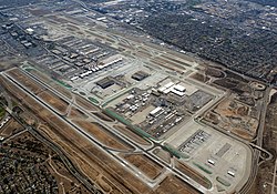
Greater Los Angeles has five airports served by commercial airlines. In addition to these airports, there are many general aviation airports in the region.

Public transportation

Rail

Local

Map of the Metrolink system Metrolink System Map.png
Map of the Metrolink system

As Greater Los Angeles' main commuter rail service, Metrolink runs eight lines through Southern California.

Los Angeles Metro Rail
Map of the Metro Rail and Metro Busway system Los Angeles Metro System Map.png
Map of the Metro Rail and Metro Busway system

The Los Angeles Metro Rail is a light rail and rapid transit system that serves primarily Los Angeles and its surrounding cities. There are several routes associated to this system, which follows:

Long-distance and intercity rail

  • A passenger train route operated by Amtrak that normally connects Chicago Union Station with San Antonio station in San Antonio, Texas. Three times per week, the Texas Eagle joins the Sunset Limited in San Antonio and continues west to Los Angeles.

Bus

Buses in Greater Los Angeles are provided by several governmental entities, including Los Angeles County Metropolitan Transportation Authority, Orange County Transportation Authority (OCTA), Riverside Transit Agency, Omnitrans (San Bernardino County), and Gold Coast Transit (Ventura County).

Roads

The Greater Los Angeles area operates on a very extensive network of public roadways that allows vehicle drivers convenient direct access to all practical destinations in the area.

Major Freeways leading into and out of Greater Los Angeles Area

Greater Los Angeles Freeways

Ferry

Santa Catalina Island is served by several ferry lines with regular daily service to Newport Beach, San Pedro, Long Beach, Marina del Rey, and Dana Point. One such line is Catalina Express.

See also

Related Research Articles

<span class="mw-page-title-main">Southern California</span> American geographic and cultural region

Southern California is a geographic and cultural region that generally comprises the southern portion of the U.S. state of California. It includes the Los Angeles metropolitan area as well as the Inland Empire. The region generally contains ten of California's 58 counties: Imperial, Kern, Los Angeles, Orange, Riverside, San Bernardino, San Diego, Santa Barbara, San Luis Obispo, and Ventura counties.

<span class="mw-page-title-main">Greater Los Angeles</span> Metropolitan area in California, US

Greater Los Angeles is the most populous metropolitan area in the U.S. state of California, encompassing five counties in Southern California extending from Ventura County in the west to San Bernardino County and Riverside County in the east, with Los Angeles County in the center, and Orange County to the southeast. The Los Angeles–Anaheim–Riverside combined statistical area (CSA) covers 33,954 square miles (87,940 km2), making it the largest metropolitan region in the United States by land area. The contiguous urban area is 2,281 square miles (5,910 km2), whereas the remainder mostly consists of mountain and desert areas. With a population of 18.4 million in 2024, it is the second-largest metropolitan area in the country, behind New York, as well as one of the largest megacities in the world.

<span class="mw-page-title-main">Pacific Electric</span> Southern California transit company

The Pacific Electric Railway Company, nicknamed the Red Cars, was a privately owned mass transit system in Southern California consisting of electrically powered streetcars, interurban cars, and buses and was the largest electric railway system in the world in the 1920s. Organized around the city centers of Los Angeles and San Bernardino, it connected cities in Los Angeles County, Orange County, San Bernardino County and Riverside County.

<span class="mw-page-title-main">California State Route 91</span> Highway in California

State Route 91 (SR 91) is a major east–west state highway in the U.S. state of California that serves several regions of the Greater Los Angeles urban area. A freeway throughout its entire length, it officially runs from Vermont Avenue in Gardena, just west of the junction with the Harbor Freeway, east to Riverside at the junction with the Pomona and Moreno Valley freeways.

<span class="mw-page-title-main">Interstate 710 and State Route 710 (California)</span> Interstate and state highway in California

Route 710, consisting of the non-contiguous segments of State Route 710 (SR 710) and Interstate 710 (I-710), is a major north–south state highway and auxiliary Interstate Highway in the Los Angeles metropolitan area of the U.S. state of California. Also called the Los Angeles River Freeway prior to November 18, 1954, the highway was initially planned to connect Long Beach and Pasadena, but a gap in the route exists from Alhambra to Pasadena through South Pasadena due to community opposition to its construction.

<span class="mw-page-title-main">Ventura Freeway</span> Freeway in Southern California

The Ventura Freeway is a freeway in southern California, United States, that runs from the Santa Barbara/Ventura county line to Pasadena in Los Angeles County. It is the principal east–west route through Ventura County and in the southern San Fernando Valley in Los Angeles County. From the Santa Barbara County line to its intersection with the Hollywood Freeway in the southeastern San Fernando Valley in Los Angeles, it is signed as U.S. Route 101 (US 101), which was built in the late 1950s and opened on April 5, 1960. The segments from the Santa Barbara County line to Sea Cliff, and from Solimar Beach to Oxnard, are also concurrent with State Route 1 (SR 1), although no signs mention SR 1 there. East of the Hollywood Freeway intersection, the Ventura Freeway is signed as State Route 134 (SR 134), which was built by 1971.

<span class="mw-page-title-main">Pomona Valley</span> Valley in Los Angeles and San Bernardino counties in California

The Pomona Valley is located in the Greater Los Angeles Area between the San Gabriel Valley and San Bernardino Valley in Southern California. The valley is approximately 30 miles (48 km) east of downtown Los Angeles.

<span class="mw-page-title-main">Metrolink (California)</span> Commuter rail system in Southern California

Metrolink is a commuter rail system in Southern California, serving Los Angeles, Orange, Riverside, San Bernardino, and Ventura counties, as well as to Oceanside in San Diego County. The system consists of eight lines and 69 stations operating on 545.6 miles (878.1 km) of track. This includes Arrow, which Metrolink operates under a contract with the San Bernardino County Transportation Authority (SBCTA).

<span class="mw-page-title-main">Cucamonga Valley</span> Valley in California, United States of America

The Cucamonga Valley is a region of southwestern San Bernardino County and northwestern Riverside County, in southern California. It is located below the San Gabriel Mountains in the Inland Empire region.

<span class="mw-page-title-main">California State Route 2</span> State highway in California, United States

State Route 2 (SR 2) is a state highway in the U.S. state of California. It connects the Los Angeles Basin with the San Gabriel Mountains and the Victor Valley in the Mojave Desert. The highway's southwestern end is at the intersection of Centinela Avenue at the Santa Monica-Los Angeles border and its northeastern end is at SR 138 east of Wrightwood. The SR 2 is divided into four segments, and it briefly runs concurrently with U.S. Route 101 (US 101) and Interstate 210 (I-210). The southwestern section of SR 2 runs along a segment of the east–west Santa Monica Boulevard, an old routing of US 66, to US 101 in East Hollywood; the second section runs along segments of both the north–south Alvarado Street and Glendale Boulevard in Echo Park; the third section to I-210 in Glendale is known as the north–south Glendale Freeway; and the northeastern portion from I-210 in La Cañada Flintridge to SR 138 is designated as the Angeles Crest Highway.

<span class="mw-page-title-main">Transportation in Los Angeles</span> Complex multimodal regional, national and international hub for passenger and freight traffic

Los Angeles has a complex multimodal transportation infrastructure, which serves as a regional, national and international hub for passenger and freight traffic. The system includes the United States' largest port complex; an extensive freight and passenger rail infrastructure, including light rail lines and rapid transit lines; numerous airports and bus lines; vehicle for hire companies; and an extensive freeway and road system. People in Los Angeles rely on cars as the dominant mode of transportation, but since 1990 the Los Angeles County Metropolitan Transportation Authority has built over one hundred miles (160 km) of light and heavy rail serving more and more parts of Los Angeles and the greater area of Los Angeles County; Los Angeles was the last major city in the United States to get a permanent rail system installed.

<span class="mw-page-title-main">Southern California freeways</span> Freeway system

A vast network of interconnected freeways in the megaregion of Southern California serves a population of over 23 million people. The Master Plan of Metropolitan Los Angeles Freeways was adopted by the Regional Planning Commission in 1947 and construction began in the early 1950s. The plan hit opposition and funding limitations in the 1970s, and by 2004, only some 61% of the original planned network had been completed.

<span class="mw-page-title-main">Foothill Freeway</span> Interstate and state highway in California

The Foothill Freeway is a freeway in the Los Angeles metropolitan area, California, United States, running from the Sylmar district of Los Angeles east to Redlands. The western segment is signed as Interstate 210 (I-210) from its western end at I-5 to SR 57 in Glendora, while the eastern segment is signed as State Route 210 (SR 210) to its eastern terminus at I-10. Under the California Streets and Highways Code, the entire Foothill Freeway is legally referred to as Route 210.

<span class="mw-page-title-main">Interstate 10 in California</span> Interstate Highway in California

Interstate 10 (I-10) is a transcontinental Interstate Highway in the United States, stretching from Santa Monica, California, to Jacksonville, Florida. The segment of I-10 in California, also known as the Pearl Harbor Memorial Highway, runs east from Santa Monica through Los Angeles, San Bernardino, and Palm Springs before crossing into the state of Arizona. In the Greater Los Angeles area, it is known as the Santa Monica and San Bernardino freeways, linked by a short concurrency on I-5 at the East Los Angeles Interchange. I-10 also has parts designated as the Rosa Parks and Sonny Bono Memorial freeways. Some parts were also formerly designated as the Christopher Columbus Transcontinental Highway. However, the California State Legislature removed this designation following the passage of a bill on August 31, 2022. I-10 is also known colloquially as "the 10" to Southern California residents (See also California English § Freeways).

<span class="mw-page-title-main">Atlantic Boulevard (Los Angeles County)</span>

Atlantic Boulevard/Atlantic Avenue/Los Robles Avenue is a major north–south thoroughfare in eastern Los Angeles County, California.

<span class="mw-page-title-main">Interstate 15 in California</span> North–south Interstate and state highway in the U.S. state of California

Route 15, consisting of the contiguous segments of State Route 15 (SR 15) and Interstate 15 (I-15), is a major north–south state highway and Interstate Highway in the U.S. state of California, connecting San Bernardino, Riverside, and San Diego Counties. The route consists of the southernmost 289.24 miles (465.49 km) of I-15, which extends north through Nevada, Arizona, Utah, Idaho, and Montana to the Canada–US border. It is a major thoroughfare for traffic between San Diego and the Inland Empire, as well as between Southern California, Las Vegas, Nevada, and the Intermountain West.

<span class="mw-page-title-main">Riverside–Downtown station</span> Train station in Riverside, California, U.S.

Riverside–Downtown station is a train station in Riverside, California, United States. It is served by three Metrolink commuter rail lines – the 91/Perris Valley Line, Inland Empire–Orange County Line, and Riverside Line – and Amtrak intercity rail service on the Southwest Chief. The station is owned by the Riverside County Transportation Commission.

<span class="mw-page-title-main">Transportation in the Inland Empire</span>

Many of the existing freeways in Southern California's Inland Empire were completed in the late 1970s. The only exception is the segment of the Foothill Freeway, State Route 210 between San Dimas and San Bernardino, completed in July 2007. In general, most of the higher paying jobs are located in Los Angeles and Orange County. Thus, workers must commute daily up to two hours in each direction on the existing network. As the population increases, traffic congestion is also projected to increase. In 2007, Forbes magazine ranked the area first in its list of America's most unhealthy commutes, beating every other major metropolitan area in the country, as Inland area drivers breathe the unhealthiest air and have the highest rate of fatal auto accidents per capita.

References

  1. "History of Transportation".
Official web sites