Wentworth Street (Hamilton, Ontario)

Last updated
Hamilton Ontario Plant c1907 LOC 6a23357u.jpg
International Harvester Company plant and waterfront in Hamilton circa 1907

Wentworth Street is a Lower City arterial road in Hamilton, Ontario, Canada. It starts off at the base of the Niagara Escarpment (mountain) on Charlton Avenue East just south of the CP lines and runs right through the city's North End industrial neighbourhood and ends north of Burlington Street East at Pier 14, which one time was used by International Harvester (1902–1992).

Hamilton, Ontario City in Ontario, Canada

Hamilton is a port city in the Canadian province of Ontario. An industrialized city in the Golden Horseshoe at the west end of Lake Ontario, Hamilton has a population of 536,917, and its metropolitan area, which includes Burlington and Grimsby, has a population of 747,545. The city is about 40 miles (64 km) southwest of Toronto, with which the Greater Toronto and Hamilton Area (GTHA) is formed.

Canada Country in North America

Canada is a country in the northern part of North America. Its ten provinces and three territories extend from the Atlantic to the Pacific and northward into the Arctic Ocean, covering 9.98 million square kilometres, making it the world's second-largest country by total area. Its southern border with the United States, stretching some 8,891 kilometres (5,525 mi), is the world's longest bi-national land border. Canada's capital is Ottawa, and its three largest metropolitan areas are Toronto, Montreal, and Vancouver.

Niagara Escarpment

The Niagara Escarpment is a long escarpment, or cuesta, in the United States and Canada that runs predominantly east/west from New York, through Ontario, Michigan, Wisconsin, and Illinois. The escarpment is most famous as the cliff over which the Niagara River plunges at Niagara Falls, for which it is named.

Contents

From 1971 to 2016 it was a one-way street southbound-only from just north of Delaware Avenue to Barton Street East. It was decided to revert it back to two-way traffic in an effort to make it less of a "freeway" and more pedestrian friendly.

History

Corner of Wentworth & Barton Streets Wentworth Barton.JPG
Corner of Wentworth & Barton Streets
Northend, Wentworth Street Northend Wentworth Street.JPG
Northend, Wentworth Street
Robert Land School, building Robert Land School.JPG
Robert Land School, building

Wentworth Street, is named after Sir John Wentworth, lieutenant-governor of Nova Scotia, from 1792 to 1808. [1]

Nova Scotia Province of Canada

Nova Scotia is one of Canada's three Maritime Provinces, and one of the four provinces that form Atlantic Canada. Its provincial capital is Halifax. Nova Scotia is the second-smallest of Canada's ten provinces, with an area of 55,284 square kilometres (21,300 sq mi), including Cape Breton and another 3,800 coastal islands. As of 2016, the population was 923,598. Nova Scotia is Canada's second-most-densely populated province, after Prince Edward Island, with 17.4 inhabitants per square kilometre (45/sq mi).

The first Westinghouse manufacturing operation outside of the United States was established in Hamilton, Ontario in 1897 on Sanford Avenue, one year after The Dominion Power and Transmission Company was formed in Hamilton. This marked a new industrial era for Hamilton. It was then incorporated in 1903, (1903–1997). [2] Company founder George Westinghouse set up a factory to build air brakes for the booming rail industry. Eventually the company was producing from its Hamilton plants electric ranges, refrigerators and washing machines. During each of the wars it was also producing guns, ammunition, anti-radar devices and bomb sights. At its peak in 1955, Westinghouse employed 11,000 people in Hamilton. (second only to Stelco) [3] Westinghouse in Hamilton was the first company in Canada to manufacture radios (1923) and electric air cleaners (1944). [2]

United States Federal republic in North America

The United States of America (USA), commonly known as the United States or America, is a country comprising 50 states, a federal district, five major self-governing territories, and various possessions. At 3.8 million square miles, the United States is the world's third or fourth largest country by total area and is slightly smaller than the entire continent of Europe, which is 3.9 million square miles. With a population of over 327 million people, the U.S. is the third most populous country. The capital is Washington, D.C., and the most populous city is New York City. Most of the country is located contiguously in North America between Canada and Mexico.

George Westinghouse 19th century American inventor and businessman

George Westinghouse Jr. was an American entrepreneur and engineer based in Pennsylvania who invented the railway air brake and was a pioneer of the electrical industry, gaining his first patent at the age of 19. Westinghouse saw the potential in alternating current as an electricity distribution system in the early 1880s and put all his resources into developing and marketing it, a move that put his business in direct competition with the Edison direct current system. In 1911 Westinghouse received the AIEE's Edison Medal "For meritorious achievement in connection with the development of the alternating current system. He was portrayed by Michael Shannon in the 2017 film The Current War.

Stelco

Stelco Holdings Inc. is a steel company based in Hamilton, Ontario, Canada. Stelco was founded in 1910 from the amalgamation of several smaller firms. It continued on for almost 100 years, until it filed for bankruptcy in 2007 and was bought by U.S. Steel. In 2016, the company was sold to Bedrock Industries of the United States, which took the company public. The company made its debut on the Toronto Stock Exchange on Nov. 3, 2017.

International Harvester became the second major United States industry to locate in Hamilton, Ontario in 1902, (1902–1992). [2] Originally known as Deering Harvester, the company plant sprawled along the Hamilton waterfront and claimed to be the "largest agricultural implement works in the British Empire." The plant was also involved in wartime production of specialized military items. The company started building heavy duty diesel trucks in Hamilton in 1959. The first to roll off the line was delivered to Dofasco, complete with a Rolls-Royce engine. [4] Hamilton won over a number of Canadian cities when it successfully lured International Harvester. The reasons the company cited for its selection of Hamilton were as follows: it had waterside property that enabled the firm to control its own docks, its proximity to the steel industry, railway connections & the Cataract Power Company supplied them with cheap energy. [5]

International Harvester company

The International Harvester Company was a United States manufacturer of agricultural machinery, construction equipment, trucks, automobiles, and household and commercial products. Its reorganized successor, after spin-off of several of those businesses, is Navistar International.

British Empire States and dominions ruled by the United Kingdom

The British Empire comprised the dominions, colonies, protectorates, mandates and other territories ruled or administered by the United Kingdom and its predecessor states. It originated with the overseas possessions and trading posts established by England between the late 16th and early 18th centuries. At its height, it was the largest empire in history and, for over a century, was the foremost global power. By 1913, the British Empire held sway over 412 million people, 23% of the world population at the time, and by 1920, it covered 35,500,000 km2 (13,700,000 sq mi), 24% of the Earth's total land area. As a result, its political, legal, linguistic and cultural legacy is widespread. At the peak of its power, the phrase "the empire on which the sun never sets" was often used to describe the British Empire, because its expanse around the globe meant that the sun was always shining on at least one of its territories.

Dofasco company

ArcelorMittal Dofasco is a steel company based in Hamilton, Ontario, Canada. Dofasco is a standalone subsidiary of ArcelorMittal, the world's largest integrated steel producer.

In 1922, the Beech-Nut Packing Company (makers of the Life Savers candy), establishes Canadian operations in Hamilton on Cumberland Avenue near Sanford Avenue at the base of the Niagara Escarpment. [2] It was reported that when the company first started producing candy it was so pleased with the treatment from the city that it distributed free boxes of gum on the street and to every retailer in the city. By 1969 the company was producing more than a billion lifesavers candies a year in 26 flavours. [3]

Life Savers brand of candy

Life Savers is an American brand of ring-shaped hard and soft candy. Its range of mints and fruit-flavored candies is known for its distinctive packaging, coming in paper-wrapped aluminum foil rolls.

A number of recording studios call Hamilton home. In 1985 Daniel Lanois, opened up Grant Avenue Studios a landmark in Hamilton, on 38 Grant Avenue, one block west of Wentworth Street South. [6] A solo artist in his own right he's made his mark as a producer for some of the world's biggest musical acts. Some of these include Bob Dylan, Peter Gabriel and U2. [7]

Daniel Roland Lanois is a Canadian record producer, guitarist, vocalist, and songwriter.

Bob Dylan American singer-songwriter, musician, poet, author, and artist

Bob Dylan is an American singer-songwriter, author, poet, and visual artist who has been a major figure in popular culture for more than fifty years. Much of his most celebrated work dates from the 1960s, when songs such as "Blowin' in the Wind" (1963) and "The Times They Are a-Changin'" (1964) became anthems for the Civil Rights Movement and anti-war movement. His lyrics during this period incorporated a wide range of political, social, philosophical, and literary influences, defied pop-music conventions and appealed to the burgeoning counterculture.

Peter Gabriel English singer-songwriter, record producer and humanitarian

Peter Brian Gabriel is an English singer, songwriter, record producer and activist who rose to fame as the original lead singer and frontman of the progressive rock band Genesis. After leaving Genesis in 1975, Gabriel launched a successful solo career with "Solsbury Hill" as his first single. His 1986 album, So, is his best-selling release and is certified triple platinum in the UK and five times platinum in the U.S. The album's most successful single, "Sledgehammer", won a record nine MTV Awards at the 1987 MTV Video Music Awards and, according to a report in 2011, it was MTV's most played music video of all time.

In 2006, the Disney film Firehouse Dog was filmed at the old Westinghouse headquarters building (1903–1997), on Wentworth Street North, (entrance one block east on Sanford Avenue) which featured the firehouse dog jumping off the roof of the burning building.

The site of the Cathedral Secondary School is the original site of the Hamilton Street Railway Company which maintained its operations at this site from 1910-1999. HSR was incorporated in 1873.

Eastend Incline Railway

Wentworth Street, at the base of the Niagara Escarpment (mountain) was the site of the city's second Incline railway (1895–1936). Back then, the Incline railway on Wentworth Street was known as the Eastend Incline Railway but was often called, The Mount Hamilton Incline Railway. [8] [9] The city's first Incline railway on James Street South, (1892–1932), was known as the Hamilton & Barton Incline Railway. [8] [9] The first day, the public was allowed free access up and down the line. By the time the Wentworth Street Incline made its last trip on 16 August 1936, it was estimated that nearly 20,000,000 trips had been made up and down the line. [10] The Eastend Incline on Wentworth Street was electrically operated and the Westend Incline on James Street depended on steam for its power. [11]

In 1929, the city's brochures were using the motto, "The City Beautiful and Hub of Canadian Highways" as well as "The City of Opportunity". In regards to the Incline railways, the brochures go on to boast, "There is no finer view anywhere on the North American continent than the panorama to be seen from the Hamilton mountain. The city below, the blue waters of Hamilton harbour and Lake Ontario. In the background, flanked on the east by the famous Niagara Fruit District and on the west by the beautiful Dundas Valley and a range of hills, combine to make a picture no artist could paint. There are several roads leading up to the summit and you can drive upon "high", but if you want to enjoy a unique experience and give the family a thrill, drive your car onto one of the Incline Railways and you will have something to tell the folks about when you go back home."

In 1914, the city leaders of the day seriously looked at the possibility of extending the Wentworth Street mountain incline tracks to a point far enough north to eliminate the heavy climb. Their plan was to have the incline tracks pass under the Toronto, Hamilton and Buffalo Railway (T.H. & B.) tracks and over the Grand Trunk Railway (GTR) tracks on a level crossing. That never came about. City businessman George Webb offered to finance the whole scheme himself on the condition that the city of Hamilton undertook construction a permanent roadway on Wentworth Street. [12] In 1915, George Webb had to defend himself when the public asked 'why the Wentworth Street incline costs more to use compared to the James Street incline?' At the time it was costing 15 cents per one hundred school kids on the James Street incline compared to 50 cents per one hundred school kids on his Wentworth Street incline. His defence was that school kids could use his incline on Wentworth any time of the day whereas on the James Street incline school kids were only allowed to be carried on school days between the morning hours of 8 to 9 and the afternoon hours of 12 noon to 2 and 4 to 5. [13]

In 1924, following the city's booming development in the east, there was some serious discussion regarding the addition of a third incline railway. The 2 locations be considered at the time were Sherman Avenue or Ottawa Street South. The population of Hamilton Mountain at the time was 6,000. [14]

In 1949 there was a petition going around town to help revive the Eastend incline, with no success. It was estimated that year 2,000 people used the Wentworth mountain stairs on a daily basis between the hours of 6 in the morning and 6 pm. Proponents of the incline argued that an elevator 'would take passengers and baby carriages to the top of Hamilton mountain and back' plus 'school children took the bus because they couldn't carry their bicycles up the steps'. The reason attributed for its closure in 1936 was the falling off in the numbers using it, due to the depression, and the depreciation of its rolling stock. [15]

Bruce Trail

One can reach the Bruce Trail on Wentworth Street South via the Wentworth Street Stairway. The trail cuts through the city along the Niagara Escarpment (mountain) and is used by many locals for a full day's hike. The trail is 430 miles long and starts at Niagara Falls, passes through Hamilton and ends at the Bruce Peninsula. Hikers are led to scenic gorges, hidden waterfalls and places of quiet charm.

Landmarks

Note: Listing of Landmarks from North to South.

Mohawk College, Wentworth building Mohawk College Wentworth.JPG
Mohawk College, Wentworth building
Wentworth Street North Wentworth Street Hamilton.JPG
Wentworth Street North
CN Railway tracks CN Tracks Wentworth.JPG
CN Railway tracks
Galley Pump/ Wentworth Tavern Wentworth Galley Pump.JPG
Galley Pump/ Wentworth Tavern
Escarpment Rail Trail Chedoke Rail Trail.JPG
Escarpment Rail Trail
Wentworth mountain-access stairway Wentworth Stairway.JPG
Wentworth mountain-access stairway

Communities

Note: Listing of neighbourhoods from North to South [17]

Major roads that cross Wentworth Street

Note: Listing of streets from North to South.

Roads that are parallel with Wentworth Street

Note: Listing of streets from West to East.

See also

Related Research Articles

Hamilton East was a federal electoral district in Ontario, Canada. It was represented in the House of Commons of Canada from 1904 to 2004. It consisted of the eastern part of the city of Hamilton, Ontario. It is considered a working class district.

James Street (Hamilton, Ontario) arterial road in Hamilton, Ontario, Canada

James Street is a Lower City arterial road in Hamilton, Ontario, Canada. It starts off at the base of the Niagara Escarpment from James Mountain Road, a mountain-access road in the city, originally was a one-way street going south throughout but now has sections of it that are two-way. It extends north to the city's waterfront at the North End where it ends at Guise Street West right in front of the Harbour West Marina Complex and the Royal Hamilton Yacht Club.

Hess Street (Hamilton, Ontario)

Hess Street is a Lower City collector road in Hamilton, Ontario, Canada. It starts off at the base of the Niagara Escarpment right before Aberdeen Avenue, and is a one-way street going north past the Durand and Central neighbourhoods. Between Main and King Street West is Hess Village, a cobblestone pedestrian zone of nightclubs, bars, and historic buildings. Hess Street then continues onwards to the waterfront where it ends at Stuart Street, right in front of the Canadian National Railway Yard.

Wellington Street (Hamilton, Ontario)

Wellington Street is a Lower City arterial road in Hamilton, Ontario, Canada. It starts off at Charlton Avenue East as a two-way street for only one block where it's then blocked off by the Corktown Park and a couple of Canadian National Railway lines that cut through it. It then starts up again north of the park on Young Street and is a one-way street the rest of the way (Southbound). It ends in the North End of the City on Burlington Street East, in front of the Lakeport Brewing Company and the Administration offices of the Hamilton Port Authority.

Queen Street (Hamilton, Ontario) street in Hamilton, Ontario, Canada

Queen Street is a Lower City arterial road in Hamilton, Ontario, Canada. It starts off at Beckett Drive, a mountain-access road in the city and is a two-way street up to Herkimer Street and a one-way street (Southbound) the rest of the way north up to the Canadian National Railway Yard where the road turns right, merging with Stuart Street which travels in a west–east direction.

Ferguson Avenue (Hamilton, Ontario)

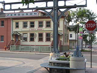
Ferguson Avenue is a Lower City collector road in Hamilton, Ontario, Canada. It is a two-way street throughout that starts off at the base of the Mountain on Foster Street. It's interrupted 3 blocks north at Corktown Park where Canadian Pacific Railway lines passes through it. Ferguson Avenue resumes again north of the Park right before Hunter Street East, extending northward past Barton Street East through the city's North End industrial neighbourhood where it ends on Dock Service Road, the site of a Royal Canadian Navy base and Pier 10.

Sherman Avenue (Hamilton, Ontario)

Sherman Avenue is a collector road in the lower portion of Hamilton, Ontario, Canada. It begins at the Niagara Escarpment just south of Cumberland Avenue and is a one-way street bisecting the industrialized northern neighbourhoods of the city. It ends at Ship Street — the site of Steel Company of Canada (Stelco).

Gage Avenue (Hamilton, Ontario)

Gage Avenue is a Lower City arterial road in Hamilton, Ontario, Canada. It starts off at Lawrence Road at the base of the Niagara Escarpment (mountain) at the south end of Gage Park. It is a two-way arterial road that extends north through the city's North End industrial neighbourhood and ends at Industrial Drive.

Ottawa Street (Hamilton, Ontario)

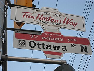
Ottawa Street is a Lower City arterial road in Hamilton, Ontario, Canada. It starts off at Lawrence Road at the base of the Niagara Escarpment (mountain) and is a two-way street throughout, cutting through the Delta and Crown Point neighbourhoods and the City's North End industrial neighbourhood. It ends at Industrial Drive, the site of the Dofasco steel company. This used to be one of the east ends' mountain access roads - it continued south over the train tracks at Lawrence Road and quickly turned right towards the brick manufacturing plant once known as Hamilton Brick. It took several turns before joining what is now the Kenilworth Access near the old water reservoir entrance. Its routing up the mountain is fairly consistent with the current Kenilworth Access with one exception - another hair-pin turn at the top; not the traffic circle that is present now. It was because of these hair-pin turns that the Hamilton Street Railway discontinued bus service on this road in 1944, and why the City planned a new Kenilworth Access to the east which opened in 1957.

Kenilworth Avenue (Hamilton, Ontario)

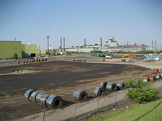
Kenilworth Avenue, is a Lower City arterial road in Hamilton, Ontario, Canada. It starts off at the Kenilworth Traffic Circle and Kenilworth Access, a mountain-access road at the base of the Niagara Escarpment (mountain) and is a two-way street throughout stretching northward through the city's North End industrial neighbourhood where it then flows underneath the Burlington Street bridge and right into Dofasco's Industrial Park.

Parkdale Avenue (Hamilton, Ontario)

Parkdale Avenue, is a Lower City arterial road in Hamilton, Ontario, Canada. It starts off just South of Lawrence Road at Hixon Road and is a two-way street throughout, stretching northward through the city's North End industrial neighbourhood and ends just north of the Nikola Tesla Boulevard East overpass at the front gates of Triple M Metal LP, a scrap & waste management company.

Centennial Parkway

Centennial Parkway, is a Lower City arterial road in Hamilton, Ontario, Canada. It is best known as the western terminus of former King's Highway 20, now maintained by the City of Hamilton. It starts off as Upper Centennial Parkway, a mountain-access road in the City right before the Canadian Pacific Railway line at the backend of Battlefield Park and is a two-way street throughout that extends north over the Queen Elizabeth Way and ends at Beach Boulevard/ Van Wagners Beach Road in front of Confederation Park.

Barton Street (Hamilton, Ontario) arterial road in the Lower City of Hamilton, Ontario, Canada

Barton Street is an arterial road in the Lower City of Hamilton, Ontario, Canada. It's also the longest street (21.0 km) in the city. It starts off at the Western end of town at Locke Street North and is a two-way street that stretches eastward through a number of different and varied communities in the city and ends in Winona at Fifty Road just West of the Hamilton/Niagara regional boundary. The street is divided in East and West portions, divided by James Street. However, the East designation does not continue through Stoney Creek, which was a separate municipality prior to amalgamation in 2001. There, the street still retains its original address numbering system, and numbers reset at the former city limits at Centennial Parkway.

Cannon Street (Hamilton, Ontario) collector road in Hamilton, Ontario

Cannon Street, is a Lower City collector road in Hamilton, Ontario, Canada. It starts off at Queen Street North as a one-way street (Westbound) up to Sherman Avenue North where it then switches over to a two-way street the rest of the way Eastward and ends just past Kenilworth Avenue North on Barons Avenue and merges with Britannia Avenue, a street that runs parallel with Cannon Street from Ottawa Street North to Barons Avenue.

Charlton Avenue (Hamilton, Ontario) street in Ontario, Canada

Charlton Avenue, is a Lower City collector road in Hamilton, Ontario, Canada. This collector road starts off just West of Dundurn Street as a one-way street (Westbound) up to James Street South where it then switches over to a two-way street the rest of the way eastward and ends at Wentworth Street South right in front of Mountain Face Park and the Escarpment Rail Trail.

Concession Street (Hamilton, Ontario)

Concession Street is an Upper City (mountain) arterial road in Hamilton, Ontario, Canada. It starts at Belvidere Avenue, just West of Sam Lawrence Park, and extends eastward past Mountain Drive Park on Upper Gage Avenue and ends shortly thereafter at East 43rd Street.

Limeridge Road is a two-way Upper City (mountain) collector road in Hamilton, Ontario, Canada. It starts off just West of Garth Street/William McCulloch Park as Limeridge Court and cuts across the Hamilton mountain eastward running parallel with the Lincoln M. Alexander Parkway and ends at Mountain Brow Boulevard, South of Mohawk Sports Park in front of Upper King's Forest Park.

Upper James Street (Hamilton, Ontario)

Upper James Street, is an Upper City (mountain) arterial road in Hamilton, Ontario, Canada. It starts at the Claremont Access, a mountain-access road in the north, and extends southward towards the John C. Munro Hamilton International Airport where it then changes its name to the Hamilton Port Dover Plank Road,. It is a two-way street throughout. As with most of the "Upper" streets, their addresses start at roughly the point where their lower counterpart finishes just below the Escarpment and were originally labelled without the "Upper" prefix.

Upper Wentworth Street is an Upper City road in Hamilton, Ontario, Canada. It starts off at Concession Street in the north and extends southward past Rymal Road. It is a two-way street throughout. As with most of the "Upper" streets, their addresses start at roughly the point where their lower counterpart finishes just below the Escarpment and were originally labeled without the "Upper" prefix.

Upper Centennial Parkway is a mountain-access road in Hamilton, Ontario, Canada. Also known as Hamilton Highway 20, the road starts off at Centennial Parkway in the Lower City beside Battlefield Park and extends south up the Niagara Escarpment and southward across the mountain where it ends at Rymal Road. It is a two-way street throughout.

References

  1. Burkholder, Mabel (1956). Barton on the Mountain. Hamilton Public Library.
  2. 1 2 3 4 "History of Industry in Hamilton, Ontario" . Retrieved 2009-07-27.Cite web requires |website= (help)
  3. 1 2 "The Hamilton Memory Project;" (Press release). The Hamilton Spectator- Souvenir Edition page MP48. June 10, 2006.
  4. "The Hamilton Memory Project;" (Press release). The Hamilton Spectator- Souvenir Edition page MP45. June 10, 2006.
  5. Weaver, John C. (1982). Hamilton: An Illustrated History. James Lorimer & Company Publishers. ISBN   0-88862-593-6.
  6. "Grant Avenue Studios/ Daniel Lanois" . Retrieved 2007-03-27.Cite web requires |website= (help)
  7. "Daniel Lanois Bio: CMT.com" . Retrieved 2007-03-27.Cite web requires |website= (help)
  8. 1 2 "Hamilton Street Railway History" . Retrieved 2007-03-26.Cite web requires |website= (help)
  9. 1 2 "Hamilton Transit History". Archived from the original on 2009-10-25. Retrieved 2007-03-26.Cite web requires |website= (help)
  10. Henley, Brian (1993). Hamilton our Lives and Times. The Hamilton Spectator. ISBN   0-9697255-0-7.
  11. "Inclines prove equal to their important task" (Press release). The Hamilton Spectator. 1924-02-29.
  12. "Incline Extension: George F Webb is willing to proceed with the work" (Press release). The Hamilton Spectator. 1914-11-12.
  13. "Explains It: George Webb tells why incline tickets cost more" (Press release). The Hamilton Spectator. 1915-12-30.
  14. "Inclines prove equal to their important task" (Press release). The Hamilton Spectator. 1924-02-29.
  15. "Get petition on Incline Issue: Residents will be asked to signify preference" (Press release). The Hamilton Spectator. 1949-07-19.
  16. Toffoletti, Paul (2007-04-16). "Seven steps to correct Mountain stairs myths". The Hamilton Spectator.Cite news requires |newspaper= (help)
  17. "Hamilton Neighbourhood Boundaries, (map.hamilton.ca)" (PDF). Archived from the original (PDF) on 2007-09-27. Retrieved 2007-05-11.Cite web requires |website= (help)