Wonder Peak

Last updated
Wonder Peak
Wonder Peak in Canada.jpg
Wonder Peak at sunset
Highest point
Elevation 2,852 m (9,357 ft) [1]
Prominence 165 m (541 ft)
Coordinates 50°53′41″N115°33′31″W / 50.89472°N 115.55861°W / 50.89472; -115.55861
Geography
Canada Alberta relief location map - transverse mercator proj.svg
Red triangle with thick white border.svg
Wonder Peak
Location in Alberta and British Columbia
Canada British Columbia relief location map.jpg
Red triangle with thick white border.svg
Wonder Peak
Wonder Peak (British Columbia)
Location Alberta
British Columbia
Parent range Canadian Rockies
Topo map NTS 82J13 Mount Assiniboine
Climbing
First ascent 1913 Conrad Kain, Boundary Commission [2]
Wonder Peak from Mount Assiniboine Provincial Park Wonder Peak from Mount Assiniboine Provincial Park.jpg
Wonder Peak from Mount Assiniboine Provincial Park

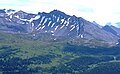
Wonder Peak is located on the border of Alberta and British Columbia in the Canadian Rockies. Situated on the Continental Divide, it also straddles the shared boundary of Banff National Park with Mount Assiniboine Provincial Park. It was named in 1913 by Arthur O. Wheeler and Conrad Kain. [1] [2]

Contents

Geology

Wonder Peak is composed of sedimentary rock laid down from the Precambrian to Jurassic periods. [3] Formed in shallow seas, this sedimentary rock was pushed east and over the top of younger rock during the Laramide orogeny. [4]

Climate

Based on the Köppen climate classification, Wonder Peak is located in a subarctic climate zone with cold, snowy winters, and mild summers. [5] Temperatures can drop below -20°C with wind chill factors below -30°C.

See also

Related Research Articles

<span class="mw-page-title-main">Mount Hector (Alberta)</span> Mountain in Banff National Park, Alberta, Canada

Mount Hector is a 3,394-metre (11,135-foot) mountain summit located in the Bow River valley of Banff National Park, in the Canadian Rockies of Alberta, Canada. The mountain was named in 1884 by George M. Dawson after James Hector, a geologist on the Palliser expedition. The mountain is located beside the Icefields Parkway, 17 km (11 mi) north of Lake Louise.

<span class="mw-page-title-main">Saint Nicholas Peak (Canada)</span> Mountain in Canada

Saint Nicholas Peak is a 2,938-metre (9,639-foot) mountain summit in the Rocky Mountains of Canada. It is located on the Continental Divide, on the Alberta-British Columbia border, in both Banff National Park and Yoho National Park. It lies at the eastern edge of the Wapta Icefield, and is part of the Waputik Mountains which are a sub-range of the Canadian Rockies.

<span class="mw-page-title-main">Popes Peak</span>

Popes Peak is a mountain on the border of Alberta and British Columbia in Western Canada, on the Continental Divide of the Americas, part of the Bow Range of the Canadian Rockies between Lake Louise Valley and Cataract Brook, bordering Banff and Yoho national parks.

<span class="mw-page-title-main">Neptuak Mountain</span> Mountain peak in Canada

Neptuak Mountain was named by Samuel E.S. Allen in 1894. "Neptuak" is the Stoney Indian word for "nine" as Neptuak Mountain is peak #9 in the Valley of the Ten Peaks. It is located on the Continental Divide, which is also the British Columbia-Alberta border in this region, and is in the Bow Range of the Park Ranges of the Canadian Rockies. The summit is a tripoint for Banff National Park, Kootenay National Park, and Yoho National Park, where the three parks share a common border.

<span class="mw-page-title-main">Mount Tuzo</span> Mountain peak in Canada

Mount Tuzo, previously "Peak Seven" or "Shagowa", was named in 1907 after its first ascendant, Henrietta L. Tuzo. It is located within the Valley of the Ten Peaks in the Canadian Rockies, along the Continental Divide, which forms the boundary between British Columbia and Alberta in this region. It also lies on the boundary shared by Banff National Park and Kootenay National Park.

<span class="mw-page-title-main">Division Mountain</span> Mountain in the country of Canada

Division Mountain is located on the Continental Divide along the Alberta - British Columbia border of Canada. It also straddles the shared boundary of Banff National Park with Kootenay National Park in the Canadian Rockies. It was named in 1919 by Charles D. Walcott since the mountain divides the Lyell Icefield from the Mons Icefield.

<span class="mw-page-title-main">Mount Synge</span>

Mount Synge is located on the Continental Divide along border of Alberta and British Columbia. It was named in 1918 after Captain Millington Henry Synge (1823–1907), British Army officer and author.

<span class="mw-page-title-main">Mount Habel</span> Mountain in Canada

Mount Habel is a 3,073-metre (10,082-foot) mountain summit located in Banff National Park on the Continental Divide along the border of Alberta and British Columbia in the Waputik Mountains, part of the Canadian Rockies. It was named in 1986 after Jean Habel. Jean Habel was a German geographer who explored the Canadian Rockies and in 1897 was the first to set foot on the Wapta Icefield which surrounds Mount Habel.

<span class="mw-page-title-main">Mount Olive (Canadian Rockies)</span> Mountain in Canada

Mount Olive is located on the Continental Divide, on the Alberta-British Columbia border, in both Banff National Park and Yoho National Park. It lies on the eastern edge of the Wapta Icefield, and is part of the Waputik Mountains. It was named in 1898 by H.B. Dixon after his wife Dixon, Olive.

<span class="mw-page-title-main">Mount Daly</span> Mountain in the country of Canada

Mount Daly is located on the border of Alberta and British Columbia. It was named in 1898 by Charles E. Fay after Charles P. Daly, a geographer. Mount Niles is located two km southwest of Daly.

<span class="mw-page-title-main">Mount Bosworth</span>

Mount Bosworth is located in the Canadian Rockies on the border of Alberta and British Columbia. The mountain is situated immediately northwest of Kicking Horse Pass and straddles the shared border of Banff National Park with Yoho National Park. It was named in 1903 after George Morris Bosworth, an executive and long-time employee of the Canadian Pacific Railway.

<span class="mw-page-title-main">Glacier Peak (Canadian Rockies)</span> Mountain in Canada

Glacier Peak is located on the border of Alberta and British Columbia in the Canadian Rockies. It was named in 1894 by Samuel E.S. Allen in reference to the glacier on the northern side of the mountain.

<span class="mw-page-title-main">Mount Bowlen</span> Mountain in Alberta/BC, Canada

Mount Bowlen is located on the border of Alberta and British Columbia and forms part of the Valley of the Ten Peaks. It was named in 1953 after John J. Bowlen, a native of Prince Edward Island, successful Alberta rancher, honorary chief of the Blackfoot, and a Lieutenant Governor of Alberta. Its former name was "Yamnee", which translates to the number 3 in the local Nakoda (Stoney) language.

<span class="mw-page-title-main">Mount Perren</span> Mountain peak in Canada

Mount Perren is located on the border of Alberta and British Columbia on the Continental Divide. It was named in 1968 after Walter Perren, a Swiss climbing guide and Parks Canada service warden. The peak forms part of the backdrop to Moraine Lake in the Valley of the Ten Peaks of Banff National Park.

<span class="mw-page-title-main">The Towers (Canada)</span>

The Towers is a 2,842-metre (9,324-foot) mountain located on the border of Alberta and British Columbia on the Continental Divide. It also straddles the shared boundary of Banff National Park with Mount Assiniboine Provincial Park. It was named in 1917 by Arthur O. Wheeler. Its nearest higher peak is Mount Magog, 2.5 km (1.6 mi) to the west.

<span class="mw-page-title-main">Mount Magog</span>

Template:Short Description

<span class="mw-page-title-main">Mount Gloria</span> Canadian mountain

Mount Gloria is located on the border of Alberta and British Columbia on the Continental Divide in Canada. It was named in 1913 by the Interprovincial Boundary Survey after Lake Gloria which lies directly north of the mountain.

<span class="mw-page-title-main">Aye Mountain</span>

Aye Mountain is located on the Canadian provincial boundary between Alberta and British Columbia on the Continental Divide. It was named in 1913 by the Interprovincial Boundary Survey.

<span class="mw-page-title-main">Castleguard Mountain</span> Mountain in Banff NP, Canada

Castleguard Mountain, also known as Mount Castleguard, is an isolated mountain located near the southern edge of the Columbia Icefield at the northern edge of Banff National Park in Alberta, Canada. In 1918, Irish land surveyor Arthur Oliver Wheeler named the mountain because of its castle-like appearance, which seemed to stand guard over the southern portion of the Columbia Icefield. Castleguard was first ascended in 1919 by the Interprovincial Boundary Commission, which determined the exact location of the boundary between British Columbia and Alberta along the continental divide.

<span class="mw-page-title-main">Tonsa</span> Mountain summit in Canada

Tonsa, or Tonsa Peak, is a 3,053-metre (10,016 ft) mountain summit located on the border of Alberta and British Columbia on the Continental Divide in the Canadian Rockies. The mountain forms part of the backdrop to Moraine Lake in the Valley of the Ten Peaks of Banff National Park. It was named in 1894 by Samuel E.S. Allen for the Stoney Indian word for the number four.

References

  1. 1 2 "Wonder Peak". PeakFinder.com. Retrieved 2019-09-16.
  2. 1 2 "Wonder Peak". Bivouac.com. Retrieved 2019-09-16.
  3. Belyea, Helen R. (1960). The Story of the Mountains in Banff National Park (PDF). parkscanadahistory.com (Report). Ottawa: Geological Survey of Canada. Archived (PDF) from the original on 2015-10-02. Retrieved 2019-09-13.
  4. Gadd, Ben (2008). Geology of the Rocky Mountains and Columbias.
  5. Peel, M. C.; Finlayson, B. L.; McMahon, T. A. (2007). "Updated world map of the Köppen−Geiger climate classification". Hydrol. Earth Syst. Sci. 11: 1633–1644. ISSN   1027-5606.