Arlington, Wyoming

Last updated

Arlington, Wyoming
Carbon County Wyoming incorporated and unincorporated areas Arlington highlighted.svg
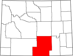
Location in Carbon County and the state of Wyoming.
Coordinates: 41°35′41″N106°12′30″W / 41.59472°N 106.20833°W / 41.59472; -106.20833
Country United States
State Wyoming
County Carbon
Area
  Total
4.1 sq mi (10.5 km2)
  Land4.1 sq mi (10.5 km2)
  Water0.0 sq mi (0.0 km2)
Elevation
7,707 ft (2,349 m)
Population
 (2010) [1]
  Total
25
  Density6.2/sq mi (2.4/km2)
Time zone UTC-7 (Mountain (MST))
  Summer (DST) UTC-6 (MDT)
Area code 307
FIPS code 56-03245 [2]
GNIS feature ID1609063 [3]
Arlington
Arlington, Wyoming, USA.JPG
USA Wyoming location map.svg
Red pog.svg
Usa edcp location map.svg
Red pog.svg
LocationSouth of Interstate 80
Coordinates 41°35′41″N106°12′30″W / 41.59472°N 106.20833°W / 41.59472; -106.20833
Built1860
NRHP reference No. 83004268 [4]
Added to NRHPNovember 25, 1983

Arlington (also Rockdale) [5] is a census-designated place (CDP) in southeastern Carbon County, Wyoming, United States. The population was 25 at the 2010 census. [6]

Contents

Geography

Arlington lies at the intersection of Interstate 80 and WYO 13, [7] northwest of Laramie and east of the city of Rawlins, the county seat of Carbon County. [8] Its elevation is 7,707 feet (2,349 m), and it is located at 41°35′41″N106°12′30″W / 41.59472°N 106.20833°W / 41.59472; -106.20833 (41.5946899, -106.2083459). [5]

According to the United States Census Bureau, the CDP has a total area of 4.1 square miles (10.5 km2), all land. [6]

History

In its earliest years, Arlington was a commercial stop along the Overland Trail. [9] Founded circa 1860, [4] it began with the establishment of a bridge and stage stop at the crossing of Rock Creek, after which it was named until the early twentieth century. [9] In 1983, the community was listed on the National Register of Historic Places as a historic district for its nineteenth-century significance. [4]

In 1882, a post office was established at Rock Creek under the name of "Rock Dale." [9] Except for a gap in 1924 and 1925, a post office with the name of Arlington was operated in the community from 1902 to 1943. [10]

Related Research Articles

Inger is an unincorporated community and census-designated place (CDP) in Itasca County, Minnesota, United States, along the Bowstring River of the Leech Lake Indian Reservation. As of the 2010 census, its population was 212.

<span class="mw-page-title-main">Summersville, Kentucky</span> Census-designated place in Kentucky, United States

Summersville is a census-designated place (CDP) and unincorporated community in Green County, Kentucky, United States. As of the 2010 census it had a population of 568.

<span class="mw-page-title-main">Marrowbone, Cumberland County, Kentucky</span> Census-designated place in Kentucky, United States

Marrowbone is a census-designated place in Cumberland County, Kentucky, United States. As of the 2010 census it had a population of 217. It has a post office, with the ZIP code of 42759.

Ezel is an unincorporated community and census-designated place (CDP) in Morgan County, Kentucky, United States. As of the 2020 census, it had a population of 209. It has a small post office, with the ZIP code 41425.

<span class="mw-page-title-main">Kenilworth, Utah</span> Census-designated place in Utah, United States

Kenilworth is a census-designated place in northern Carbon County, Utah, United States.

<span class="mw-page-title-main">McGregor, North Dakota</span> Census-designated place in North Dakota, United States

McGregor is an unincorporated community and census-designated place (CDP) in northeastern Williams County, North Dakota, United States. It lies along North Dakota Highway 40, northeast of the city of Williston, the county seat of Williams County. McGregor's elevation is 2,218 feet (676 m). Although unincorporated, it has a post office, with the ZIP code of 58755. It was first listed as a CDP prior to the 2020 census.

<span class="mw-page-title-main">Menoken, North Dakota</span> Census-designated place in North Dakota, United States

Menoken is an unincorporated community and a census-designated place (CDP) in southwestern Burleigh County, North Dakota, United States. It was designated as part of the U.S. Census Bureau's Participant Statistical Areas Program on June 10, 2010. It was not counted separately during the 2000 Census, but was included in the 2010 Census, where a population of 70 was reported.

<span class="mw-page-title-main">Champion, Nebraska</span> Census-designated place in Nebraska, United States

Champion is an unincorporated community and census-designated place in central Chase County, Nebraska, United States. As of the 2010 census, it had a population of 103. It has a post office with the ZIP code 69023.

<span class="mw-page-title-main">Enders, Nebraska</span> Census-designated place in Nebraska, United States

Enders is an unincorporated community and census-designated place in Chase County, Nebraska, United States. As of the 2010 census it had a population of 42. Although Enders is unincorporated, it has a post office, with the ZIP code of 69027.

<span class="mw-page-title-main">Salt Rock, West Virginia</span> Census-designated place in West Virginia, United States

Salt Rock is a census-designated place (CDP) in southern Cabell County, West Virginia, United States. As of the 2010 census, its population was 388. It lies along West Virginia Route 10 southeast of the city of Huntington, the county seat of Cabell County. Its elevation is 581 feet (177 m). Although Salt Rock is unincorporated, it has a post office, with the ZIP code of 25559. The community most likely was so named on account of there being a small-scale local salt manufacturing industry.

Freedom is an unincorporated community in both northeastern Caribou County, Idaho, and northwestern Lincoln County, Wyoming, in the United States; the Wyoming portion of the community is also a census-designated place (CDP). The population was 247 at the 2020 census.

Conroy is an unincorporated community and census-designated place (CDP) in central Iowa County, Iowa, United States. It lies along local roads southeast of the city of Marengo, the county seat of Iowa County. Its elevation is 879 feet (268 m). Conroy has a post office with the ZIP Code of 52220, which opened on 5 January 1885. As of the 2020 census the population was 252.

<span class="mw-page-title-main">Beulah, Wyoming</span> CDP in Wyoming, United States

Beulah is a census-designated place (CDP) in eastern Crook County, Wyoming, United States, along Sand Creek, a tributary of the Belle Fourche River. According to local residents, the population is 33. When the 2010 census reported the population as 73, the highway sign at the town entrance was changed. In 2012, Beulah residents succeeded in appealing to the Wyoming Governor to remove the new sign and replace it with one that proclaimed the population to be 33.

<span class="mw-page-title-main">Carpenter, Wyoming</span> Census-designated place in Wyoming, United States

Carpenter is an unincorporated community and census-designated place in southeastern Laramie County, Wyoming, United States. As of the 2010 census it had a population of 94. It lies along WYO 214 east of the city of Cheyenne, the county seat of Laramie County and capital of Wyoming. Its elevation is 5,440 feet (1,658 m). Although Carpenter is unincorporated, it has had a post office since 1907, with the ZIP code of 82054.

<span class="mw-page-title-main">Hillsdale, Wyoming</span> Unincorporated community & census-designated place in Wyoming, United States

Hillsdale is an unincorporated community and census-designated place in southeastern Laramie County, Wyoming, United States. As of the 2010 census, it had a population of 47. It lies along local roads east of the city of Cheyenne, the county seat of Laramie County. Its elevation is 5,640 feet (1,720 m) above sea level. Although Hillsdale is unincorporated, it has a post office, with the ZIP code of 82060. Public education in the community of Hillsdale is provided by Laramie County School District #2.

Saddlestring is an unincorporated community in northwestern Johnson County, Wyoming, United States, on the eastern edge of the Bighorn National Forest. It lies along local roads northwest of the city of Buffalo, the county seat of Johnson County. Saddlestring possessed its own post office from 1946 to 1965, and from 1967 to 1999; although the post office is now closed, Saddlestring retains its old ZIP Code of 82840. The post office building still exists; located on the HF Bar Ranch, it is a contributing property to a historic district located on the ranch. The oldest building in Saddlestring is the log barn, which is attached to the Rock Creek Rod and Gun Club.

<span class="mw-page-title-main">Wildorado, Texas</span> Unincorporated community in Texas, United States

Wildorado is an unincorporated community in Oldham County, Texas, United States.

Nabesna is a census-designated place and unincorporated community in northern Copper River Census Area, Alaska, United States, in the northern part of the Wrangell-St. Elias National Park and Preserve. It lies along the Nabesna Road, a gravel road that connects it to the Tok Cut-Off at Slana. Its elevation is 2,979 feet (908 m). Founded by and named for the Nabesna Mining Company, the community received a post office in 1909. Located at the base of White Mountain in the Wrangell Mountains, it lies west of the Nabesna River. According to the 2020 census, there were two people residing at this location.

Nathalie is an unincorporated community and census-designated place (CDP) in Halifax County, Virginia, United States, in the south-central region of the state. The population as of the 2010 census was 183.

<span class="mw-page-title-main">Animas, New Mexico</span> Census-designated place in New Mexico, United States

Animas is an unincorporated community and census-designated place (CDP) in west-central Hidalgo County, New Mexico, United States, in the southwestern corner of the state. As of the 2010 census it had a population of 237.

References

  1. "2010 City Population and Housing Occupancy Status". U.S. Census Bureau. Retrieved July 13, 2012.[ dead link ]
  2. "U.S. Census website". United States Census Bureau . Retrieved January 31, 2008.
  3. "US Board on Geographic Names". United States Geological Survey. October 25, 2007. Retrieved January 31, 2008.
  4. 1 2 3 "National Register Information System". National Register of Historic Places . National Park Service. March 13, 2009.
  5. 1 2 U.S. Geological Survey Geographic Names Information System: Arlington, Wyoming
  6. 1 2 "Geographic Identifiers: 2010 Demographic Profile Data (G001): Arlington CDP, Wyoming". U.S. Census Bureau, American Factfinder. Retrieved October 1, 2015.[ dead link ]
  7. Topographical map of Arlington [ permanent dead link ], United States Geological Survey. Accessed 2009-08-11.
  8. Rand McNally. The Road Atlas '05. Chicago: Rand McNally, 2005, 116.
  9. 1 2 3 Rock Creek Stage Station Historic District [ permanent dead link ], Wyoming State Historic Preservation Office, 2009-07-16. Accessed 2009-08-11.
  10. U.S. Geological Survey Geographic Names Information System: Arlington Post Office