Ashland, Mississippi | |
---|---|
Motto(s): "Small Town Living, Big City Pride" | |
Coordinates: 34°50′03″N89°10′40″W / 34.83417°N 89.17778°W | |
Country | United States |
State | Mississippi |
County | Benton |
Area | |
• Total | 1.82 sq mi (4.72 km2) |
• Land | 1.82 sq mi (4.72 km2) |
• Water | 0.00 sq mi (0.00 km2) |
Elevation | 646 ft (197 m) |
Population (2020) | |
• Total | 551 |
• Density | 302.08/sq mi (116.62/km2) |
Time zone | UTC-6 (Central (CST)) |
• Summer (DST) | UTC-5 (CDT) |
ZIP code | 38603 |
Area code | 662 |
FIPS code | 28-02140 |
GNIS feature ID | 2405174 [2] |
Website | www |
Ashland is a town in Benton County, Mississippi, United States and the county seat. [3] The population was 551 at the 2020 census, down from 569 at the 2010 census. [4] Ashland was incorporated on March 8, 1871, and has a Mayor-Aldermen form of government.
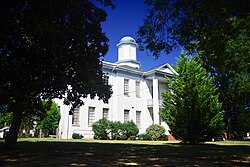
Ashland was established in 1871 as the county seat for the Benton County, which had been created the previous year. The Benton County Courthouse, the focus of the town's main square, was constructed in 1873. Many of Ashland's earliest residents had relocated from Salem, an older community to the west that had been destroyed during the Civil War. [5]
Ashland is 18 miles (29 km) east of Holly Springs. The town is concentrated along Mississippi Highway 370, east of its intersection with Mississippi Highway 5. The Tennessee border is 14 miles (23 km) to the north.
According to the United States Census Bureau, Ashland has a total area of 1.8 square miles (4.7 km2), all land.
The climate in this area is characterized by hot, humid summers and generally mild to cool winters. According to the Köppen Climate Classification system, Ashland has a humid subtropical climate, abbreviated "Cfa" on climate maps. [6]
Census | Pop. | Note | %± |
---|---|---|---|
1880 | 174 | — | |
1890 | 138 | −20.7% | |
1900 | 162 | 17.4% | |
1910 | 146 | −9.9% | |
1920 | 190 | 30.1% | |
1930 | 228 | 20.0% | |
1940 | 354 | 55.3% | |
1950 | 328 | −7.3% | |
1960 | 309 | −5.8% | |
1970 | 348 | 12.6% | |
1980 | 532 | 52.9% | |
1990 | 490 | −7.9% | |
2000 | 577 | 17.8% | |
2010 | 569 | −1.4% | |
2020 | 551 | −3.2% | |
U.S. Decennial Census [7] |
As of the census [8] of 2000, there were 577 people, 207 households, and 142 families residing in the town. The population density was 316.0 inhabitants per square mile (122.0/km2). There were 227 housing units at an average density of 124.3 per square mile (48.0/km2). The racial makeup of the town was 95.1% White, 0.8% African American, 0.5% Native American, 0.4% Asian, 0.2% from other races, and 3.1% from two or more races. Hispanic or Latino of any race were 1.7% of the population.
There were 207 households, out of which 25.6% had children under the age of 18 living with them, 55.1% were married couples living together, 11.6% had a female householder with no husband present, and 31.4% were non-families. 28.5% of all households were made up of individuals, and 17.4% had someone living alone who was 65 years of age or older. The average household size was 2.23 and the average family size was 2.68.
In the town, the population was spread out, with 15.9% under the age of 18, 8.7% from 18 to 24, 22.5% from 25 to 44, 21.8% from 45 to 64, and 31.0% who were 65 years of age or older. The median age was 47 years. For every 100 females, there were 83.8 males. For every 100 females age 18 and over, there were 87.3 males.
The median income for a household in the town was $28,088, and the median income for a family was $29,911. Males had a median income of $24,375 versus $20,455 for females. The per capita income for the town was $14,073. About 14.6% of families and 19.4% of the population were below the poverty line, including 30.2% of those under age 18 and 22.1% of those age 65 or over.
As of 2018, the mayor of Ashland is Mitch Carroll, and Sandra Gresham, Greg Thompson, Mark Ehrie, and Rocky Miller, make up the Board of Aldermen. Carroll was elected mayor in 2007 in a special election to fill the vacancy left by Bill Stone, who had been elected to the Mississippi State Senate. Carroll defeated his brother, Mike Carroll, by 17 votes to secure the position.
Ashland Academy was established in Ashland in 1882. [9]
Ashland is served by the Benton County School District. Ashland High School is the public high school in Ashland and serves students from Benton County, Mississippi. [10]
Yazoo County is a county located in the U.S. state of Mississippi. As of the 2020 census, the population was 26,743. The county seat is Yazoo City. It is named for the Yazoo River, which forms its western border. Its name is said to come from a Choctaw language word meaning "River of Death".
Carroll County is a county in the U.S. state of Mississippi. As of the 2020 census, the population was 9,998. Its county seats are Carrollton and Vaiden. The county is named for Charles Carroll of Carrollton, the last surviving signatory of the Declaration of Independence.
Benton County is a county located in the U.S. state of Mississippi. As of the 2020 census, the population was 7,646. Its county seat is Ashland.
Ashland is a city in Clay County, Alabama, United States. The population was 2,037 at the 2010 census. The city is the county seat of Clay County.
Mount Carroll is a city in and the county seat of Carroll County, Illinois, United States. The population was 1,479 at the 2020 census.
Ashland is a city in and the county seat of Clark County, Kansas, United States. As of the 2020 census, the population of the city was 783.
Ashland is a village in the northernmost portion of Natchitoches Parish, Louisiana, United States. A few residences and a convenience store to the north spill over into neighboring Bienville Parish. The population was 291 at the 2000 census but declined nine percent to 269 in 2010. The median age was 45.7 years. Ashland is part of the Natchitoches Micropolitan Statistical Area.
Rienzi is a town in Alcorn County, Mississippi, United States. The population was 317 at the 2010 census.
Hickory Flat is a town in Benton County, Mississippi, United States. The population was 601 at the 2010 census.
Snow Lake Shores is a town in Benton County, Mississippi, United States. The population was 319 at the 2010 census.
Carrollton is a town in and the second county seat of Carroll County, Mississippi, United States, which is within the Mississippi Delta. The population was 190 at the 2010 census, down from 408 in 2000. Centrally located in the county, the town is part of the Greenwood, Mississippi micropolitan area. The first county seat, Vaiden, was founded in the eastern part of the county during its early settlement.
Vaiden is a town in Carroll County, Mississippi, United States and its first county seat. The population was 734 at the 2010 census. It is part of the Greenwood, Mississippi micropolitan area.
Marion is a town in Lauderdale County, Mississippi, United States. It is a northeastern suburb of Meridian, the county seat. The population of Marion was 1,479 at the 2010 census.
Metcalfe is a town in Washington County, Mississippi, United States. The population was 1,067 at the 2010 census. The county is located on the western border of the state, with the Mississippi River on the west. It is within the Mississippi Delta.
Caruthersville is a city in and the county seat of Pemiscot County, Missouri, United States, located along the Mississippi River in the Bootheel region of the state's far southeast. The population was 5,562, according to the 2020 census.
Benton is a town in Grafton County, New Hampshire, United States. The population was 374 at the 2020 census. Located in the White Mountains, Benton is largely surrounded by the White Mountain National Forest. The town is crossed by the Appalachian Trail.
Potts Camp is a town in Marshall County, Mississippi, United States. The population was 416 at the 2020 census, down from 523 in 2010.
Falling Spring is a town in Greenbrier County, West Virginia, United States. It is also known as Renick from the name of its post office. The population was 171 at the 2020 census.
Hamlin is a town in and the county seat of Lincoln County, West Virginia, United States, along the Mud River. The population was recorded as 1,040 at the 2020 census. It is part of the Huntington–Ashland metropolitan area.
The Columbia metropolitan area is the region centered around the City of Columbia in the U.S. state of Missouri. Located in Mid-Missouri, it consists of five counties: Boone, Audrain, Randolph, Cooper, and Howard. The population was estimated at 256,640 in 2017, making it the 4th largest metropolitan area in Missouri. Columbia is home to the University of Missouri, and is Missouri's fourth most-populous and fastest growing city, with an estimated 121,717 residents as of 2017. Other significant cities in the area include Moberly, Mexico, Boonville, Vandalia, Centralia, and Fayette.