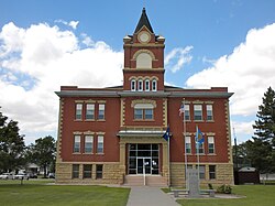
Atwood, Kansas

Last updated

Atwood, Kansas
Rawlin Co KS Courthouse.JPG
Rawlins County Kansas Incorporated and Unincorporated areas Atwood Highlighted.svg
Location within Rawlins County and Kansas
Map of Rawlins Co, Ks, USA.png
Coordinates: 39°48′36″N101°02′31″W / 39.81000°N 101.04194°W / 39.81000; -101.04194 [1]
Country United States
State Kansas
County Rawlins
Founded1875
Incorporated 1885
Named for Attwood Matheny
Area
[2]
  Total1.12 sq mi (2.91 km2)
  Land1.06 sq mi (2.75 km2)
  Water0.06 sq mi (0.16 km2)
Elevation
[1]
2,854 ft (870 m)
Population
 (2020) [3]
  Total1,290
  Density1,200/sq mi (440/km2)
Time zone UTC-6 (CST)
  Summer (DST) UTC-5 (CDT)
ZIP code
67730
Area code 785
FIPS code 20-03150
GNIS ID 2394021 [1]
Website cityofatwoodks.com

Atwood is a city in and the county seat of Rawlins County, Kansas, United States. [1] As of the 2020 census, the population of the city was 1,290. [3]

Contents

History

In 1875, T.A. Andrews and J.M. Matheny traveled to Rawlins County and started a town site about two miles east of the current city. The city of Attwood (with two t's) was named after Attwood Matheny, the 14-year-old son who accompanied his father on the journey. In 1882, the U.S. Post Office requested permission to drop one "t" thus becoming Atwood. In 1881, Atwood became the county seat of Rawlins County. [4] [5]

Geography

According to the United States Census Bureau, the city has a total area of 1.10 square miles (2.85 km2), of which 1.04 square miles (2.69 km2) is land and 0.06 square miles (0.16 km2) is water. [6]

Climate

According to the Köppen Climate Classification system, Atwood has a semi-arid climate, abbreviated "BSk" on climate maps. [7]

Climate data for Atwood, Kansas, 1991–2020 normals, extremes 1908–present
MonthJanFebMarAprMayJunJulAugSepOctNovDecYear
Record high °F (°C)82
(28)
84
(29)
92
(33)
98
(37)
104
(40)
113
(45)
118
(48)
110
(43)
107
(42)
101
(38)
87
(31)
81
(27)
118
(48)
Mean maximum °F (°C)65.8
(18.8)
71.0
(21.7)
82.1
(27.8)
88.8
(31.6)
95.3
(35.2)
101.8
(38.8)
104.3
(40.2)
102.5
(39.2)
98.1
(36.7)
89.7
(32.1)
77.8
(25.4)
67.6
(19.8)
106.0
(41.1)
Mean daily maximum °F (°C)42.6
(5.9)
45.5
(7.5)
56.8
(13.8)
65.5
(18.6)
75.1
(23.9)
87.1
(30.6)
92.4
(33.6)
89.7
(32.1)
81.8
(27.7)
67.6
(19.8)
54.2
(12.3)
43.6
(6.4)
66.8
(19.4)
Daily mean °F (°C)28.9
(−1.7)
31.4
(−0.3)
41.1
(5.1)
49.9
(9.9)
60.4
(15.8)
71.8
(22.1)
77.3
(25.2)
75.0
(23.9)
66.1
(18.9)
51.8
(11.0)
39.3
(4.1)
30.0
(−1.1)
51.9
(11.1)
Mean daily minimum °F (°C)15.1
(−9.4)
17.2
(−8.2)
25.4
(−3.7)
34.4
(1.3)
45.6
(7.6)
56.6
(13.7)
62.2
(16.8)
60.3
(15.7)
50.3
(10.2)
36.1
(2.3)
24.3
(−4.3)
16.4
(−8.7)
37.0
(2.8)
Mean minimum °F (°C)−3.9
(−19.9)
−1.0
(−18.3)
8.4
(−13.1)
19.5
(−6.9)
30.7
(−0.7)
43.0
(6.1)
51.3
(10.7)
49.6
(9.8)
34.8
(1.6)
19.1
(−7.2)
7.6
(−13.6)
−2.1
(−18.9)
−10.0
(−23.3)
Record low °F (°C)−33
(−36)
−27
(−33)
−22
(−30)
1
(−17)
15
(−9)
31
(−1)
39
(4)
35
(2)
18
(−8)
1
(−17)
−17
(−27)
−34
(−37)
−34
(−37)
Average precipitation inches (mm)0.44
(11)
0.60
(15)
1.05
(27)
2.30
(58)
3.23
(82)
3.21
(82)
3.40
(86)
3.20
(81)
1.69
(43)
1.57
(40)
0.81
(21)
0.58
(15)
22.08
(561)
Average snowfall inches (cm)5.0
(13)
6.1
(15)
4.5
(11)
3.1
(7.9)
0.6
(1.5)
0.0
(0.0)
0.0
(0.0)
0.0
(0.0)
0.0
(0.0)
1.6
(4.1)
3.8
(9.7)
4.0
(10)
28.7
(72.2)
Average precipitation days (≥ 0.01 in)2.53.64.76.99.58.68.47.75.15.63.62.869.0
Average snowy days (≥ 0.1 in)1.92.31.80.30.10.00.00.00.00.61.61.910.5
Source: NOAA [8] [9] [10]

Demographics

Historical population
CensusPop.Note
1890 450
1900 4868.0%
1910 68039.9%
1920 91935.1%
1930 1,10620.3%
1940 1,40827.3%
1950 1,61314.6%
1960 1,90618.2%
1970 1,658−13.0%
1980 1,6650.4%
1990 1,388−16.6%
2000 1,279−7.9%
2010 1,194−6.6%
2020 1,2908.0%
U.S. Decennial Census

2020 census

The 2020 United States census counted 1,290 people, 557 households, and 324 families in Atwood. [11] [12] The population density was 1,213.5 per square mile (468.6/km2). There were 648 housing units at an average density of 609.6 per square mile (235.4/km2). [12] [13] The racial makeup was 87.21% (1,125) white or European American (84.11% non-Hispanic white), 1.01% (13) black or African-American, 0.16% (2) Native American or Alaska Native, 0.31% (4) Asian, 0.0% (0) Pacific Islander or Native Hawaiian, 3.64% (47) from other races, and 7.67% (99) from two or more races. [14] Hispanic or Latino of any race was 9.46% (122) of the population. [15]

Of the 557 households, 28.0% had children under the age of 18; 43.4% were married couples living together; 27.5% had a female householder with no spouse or partner present. 37.5% of households consisted of individuals and 18.5% had someone living alone who was 65 years of age or older. [12] The average household size was 2.1 and the average family size was 2.5. [16] The percent of those with a bachelor’s degree or higher was estimated to be 12.9% of the population. [17]

23.3% of the population was under the age of 18, 5.9% from 18 to 24, 22.7% from 25 to 44, 21.6% from 45 to 64, and 26.4% who were 65 years of age or older. The median age was 42.4 years. For every 100 females, there were 106.7 males. [12] For every 100 females ages 18 and older, there were 108.2 males. [12]

The 2016-2020 5-year American Community Survey estimates show that the median household income was $65,063 (with a margin of error of +/- $12,385) and the median family income was $75,987 (+/- $3,553). [18] Males had a median income of $37,381 (+/- $8,708) versus $31,181 (+/- $5,889) for females. The median income for those above 16 years old was $35,152 (+/- $3,951). [19] Approximately, 3.0% of families and 5.8% of the population were below the poverty line, including 7.8% of those under the age of 18 and 6.5% of those ages 65 or over. [20] [21]

2010 census

As of the census [22] of 2010, there were 1,194 people, 568 households, and 299 families residing in the city. The population density was 1,148.1 inhabitants per square mile (443.3/km2). There were 666 housing units at an average density of 640.4 per square mile (247.3/km2). The racial makeup of the city was 97.2% White, 0.2% African American, 0.3% Native American, 0.1% Asian, 1.0% from other races, and 1.3% from two or more races. Hispanic or Latino of any race were 2.9% of the population.

There were 568 households, of which 20.2% had children under the age of 18 living with them, 43.0% were married couples living together, 6.2% had a female householder with no husband present, 3.5% had a male householder with no wife present, and 47.4% were non-families. 44.7% of all households were made up of individuals, and 23.2% had someone living alone who was 65 years of age or older. The average household size was 2.03 and the average family size was 2.84.

The median age in the city was 50.9 years. 20.3% of residents were under the age of 18; 4.7% were between the ages of 18 and 24; 17% were from 25 to 44; 29.5% were from 45 to 64; and 28.6% were 65 years of age or older. The gender makeup of the city was 47.4% male and 52.6% female.

2000 census

As of the census [23] of 2000, there were 1,279 people, 577 households, and 347 families residing in the city. The population density was 1,229.7 inhabitants per square mile (474.8/km2). There were 708 housing units at an average density of 680.7 per square mile (262.8/km2). The racial makeup of the city was 98.67% White, 0.16% African American, 0.23% Native American, and 0.94% from two or more races. Hispanic or Latino of any race were 0.39% of the population.

There were 577 households, out of which 23.4% had children under the age of 18 living with them, 52.0% were married couples living together, 6.6% had a female householder with no husband present, and 39.7% were non-families. 36.9% of all households were made up of individuals, and 20.3% had someone living alone who was 65 years of age or older. The average household size was 2.12 and the average family size was 2.78.

In the city, the population was spread out, with 21.7% under the age of 18, 3.5% from 18 to 24, 21.7% from 25 to 44, 23.5% from 45 to 64, and 29.6% who were 65 years of age or older. The median age was 48 years. For every 100 females, there were 89.8 males. For every 100 females age 18 and over, there were 84.2 males.

As of 2000 the median income for a household in the city was $30,221, and the median income for a family was $39,375. Males had a median income of $27,768 versus $19,063 for females. The per capita income for the city was $16,161. About 4.5% of families and 10.7% of the population were below the poverty line, including 10.8% of those under age 18 and 10.7% of those age 65 or over.

Area attractions

Area events

Education

The community is served by Rawlins County USD 105 public school district, [25] formed in 2003 by the consolidation of Herndon USD 317 and Atwood USD 318. [26] The district has two schools in Atwood:

Infrastructure

Transportation

Highway

US-36 and K-25 highways cross in Atwood.

Rail

Nebraska Kansas Colorado Railway passes through Atwood.

Airport

Notable people

See also

Related Research Articles

<span class="mw-page-title-main">Rawlins County, Kansas</span> County in Kansas, United States

Rawlins County is a county located in the U.S. state of Kansas. Its county seat and largest city is Atwood. As of the 2020 census, the county population was 2,561. It was named after John Rawlins, a general in the American Civil War.

<span class="mw-page-title-main">Garnett, Kansas</span> City in Anderson County, Kansas

Garnett is a city in and the county seat of Anderson County, Kansas, United States. As of the 2020 census, the population of the city was 3,242.

<span class="mw-page-title-main">Kinsley, Kansas</span> City in Edwards County, Kansas

Kinsley is a city in and the county seat of Edwards County, Kansas, United States. As of the 2020 census, the population of the city was 1,456. It is located along Highway 50.

<span class="mw-page-title-main">Howard, Kansas</span> City in Elk County, Kansas

Howard is a city in and the county seat of Elk County, Kansas, United States. As of the 2020 census, the population of the city was 570.

<span class="mw-page-title-main">Gove City, Kansas</span> City in Gove County, Kansas

Gove City, more commonly known as Gove, is a city in and the county seat of Gove County, Kansas, United States. As of the 2020 census, the population of the city was 80.

<span class="mw-page-title-main">Cimarron, Kansas</span> City in Gray County, Kansas

Cimarron is a city in and the county seat of Gray County, Kansas, United States. As of the 2020 census, the population of the city was 1,981. It is located along Highway 50.

<span class="mw-page-title-main">Jetmore, Kansas</span> City in Hodgeman County, Kansas

Jetmore is a city in and the county seat of Hodgeman County, Kansas, United States. As of the 2020 census, the population of the city was 770.

<span class="mw-page-title-main">Kingman, Kansas</span> City in Kingman County, Kansas

Kingman is a city in and the county seat of Kingman County, Kansas, United States. As of the 2020 census, the population of the city was 3,105.

<span class="mw-page-title-main">Meade, Kansas</span> City in Meade County, Kansas

Meade is a city in and the county seat of Meade County, Kansas, United States. As of the 2020 census, the population of the city was 1,505.

<span class="mw-page-title-main">Ness City, Kansas</span> City in Ness County, Kansas

Ness City is a city in and the county seat of Ness County, Kansas, United States. As of the 2020 census, the population of the city was 1,329. Ness City is famous for its four-story Old Ness County Bank Building located downtown, and nicknamed Skyscraper of the Plains.

<span class="mw-page-title-main">Lyndon, Kansas</span> City in Osage County, Kansas

Lyndon is a city in, and the county seat of Osage County, Kansas, United States. As of the 2020 census, the population of the city was 1,037.

<span class="mw-page-title-main">Minneapolis, Kansas</span> City in Ottawa County, Kansas

Minneapolis is a city in and the county seat of Ottawa County, Kansas, United States. As of the 2020 census, the population of the city was 1,946.

<span class="mw-page-title-main">Herndon, Kansas</span> City in Rawlins County, Kansas

Herndon is a city in Rawlins County, Kansas, United States. As of the 2020 census, the population of the city was 119. It is located approximately 12.5 miles (20.1 km) south of the Kansas-Nebraska state border.

<span class="mw-page-title-main">McDonald, Kansas</span> City in Rawlins County, Kansas

McDonald is a city in Rawlins County, Kansas, United States. As of the 2020 census, the population of the city was 113.

<span class="mw-page-title-main">Belleville, Kansas</span> City in Republic County, Kansas

Belleville is a city in and the county seat of Republic County, Kansas, United States. As of the 2020 census, the population of the city was 2,007.

<span class="mw-page-title-main">Andale, Kansas</span> City in Sedgwick County, Kansas

Andale is a city in Sedgwick County, Kansas, United States. As of the 2020 census, the population of the city was 941.

<span class="mw-page-title-main">Johnson City, Kansas</span> City in Stanton County, Kansas

Johnson City is a city in and the county seat of Stanton County, Kansas, United States. As of the 2020 census, the population of the city was 1,464.

<span class="mw-page-title-main">Alma, Kansas</span> City in Wabaunsee County, Kansas

Alma is a city in and the county seat of Wabaunsee County, Kansas, United States. As of the 2020 census, the population of the city was 802.

<span class="mw-page-title-main">Leoti, Kansas</span> City in Wichita County, Kansas

Leoti is a city in and the county seat of Wichita County, Kansas, United States. As of the 2020 census, the population of the city was 1,475.

<span class="mw-page-title-main">Ludell, Kansas</span> Unincorporated community in Rawlins County, Kansas

Ludell is an unincorporated community in Rawlins County, Kansas, United States. As of the 2020 census, the population of the community and nearby areas was 41. It is 5.5 miles (8.9 km) northeast of Atwood.

References

  1. 1 2 3 4 U.S. Geological Survey Geographic Names Information System: Atwood, Kansas
  2. "2019 U.S. Gazetteer Files". United States Census Bureau. Retrieved July 24, 2020.
  3. 1 2 "Profile of Atwood, Kansas in 2020". United States Census Bureau. Archived from the original on December 1, 2021. Retrieved November 30, 2021.
  4. Atwood history Archived November 7, 2011, at the Wayback Machine
  5. Blackmar, Frank Wilson (1912). Kansas: A Cyclopedia of State History, Embracing Events, Institutions, Industries, Counties, Cities, Towns, Prominent Persons, Etc. Standard Publishing Company. pp.  118.
  6. "US Gazetteer files 2010". United States Census Bureau. Archived from the original on January 12, 2012. Retrieved July 6, 2012.
  7. Climate Summary for Atwood, Kansas
  8. "U.S. Climate Normals Quick Access – Station: Atwood, KS". National Oceanic and Atmospheric Administration. Retrieved November 27, 2023.
  9. "NOAA Online Weather Data – NWS Goodland". National Weather Service. Retrieved November 27, 2023.
  10. "xmACIS2". National Oceanic and Atmospheric Administration. Retrieved November 27, 2023.
  11. "US Census Bureau, Table P16: HOUSEHOLD TYPE". data.census.gov. Retrieved December 31, 2023.
  12. 1 2 3 4 5 "US Census Bureau, Table DP1: PROFILE OF GENERAL POPULATION AND HOUSING CHARACTERISTICS". data.census.gov. Retrieved December 31, 2023.
  13. Bureau, US Census. "Gazetteer Files". Census.gov. Retrieved December 30, 2023.
  14. "US Census Bureau, Table P1: RACE". data.census.gov. Retrieved December 31, 2023.
  15. "US Census Bureau, Table P2: HISPANIC OR LATINO, AND NOT HISPANIC OR LATINO BY RACE". data.census.gov. Retrieved December 31, 2023.
  16. "US Census Bureau, Table S1101: HOUSEHOLDS AND FAMILIES". data.census.gov. Retrieved December 31, 2023.
  17. "US Census Bureau, Table S1501: EDUCATIONAL ATTAINMENT". data.census.gov. Retrieved December 31, 2023.
  18. "US Census Bureau, Table S1903: MEDIAN INCOME IN THE PAST 12 MONTHS (IN 2020 INFLATION-ADJUSTED DOLLARS)". data.census.gov. Retrieved December 31, 2023.
  19. "US Census Bureau, Table S2001: EARNINGS IN THE PAST 12 MONTHS (IN 2020 INFLATION-ADJUSTED DOLLARS)". data.census.gov. Retrieved December 31, 2023.
  20. "US Census Bureau, Table S1701: POVERTY STATUS IN THE PAST 12 MONTHS". data.census.gov. Retrieved December 31, 2023.
  21. "US Census Bureau, Table S1702: POVERTY STATUS IN THE PAST 12 MONTHS OF FAMILIES". data.census.gov. Retrieved December 31, 2023.
  22. "U.S. Census website". United States Census Bureau . Retrieved July 6, 2012.
  23. "U.S. Census website". United States Census Bureau . Retrieved January 31, 2008.
  24. Rawlins County Historical Museum
  25. "USD 105 Map" (PDF). Kansas Department of Transportation . Retrieved April 26, 2020.
  26. "School consolidations in Kansas for past decade". The Topeka Capital-Journal . July 24, 2011. Retrieved April 26, 2020.
  27. Moss, Irv. "Uhlaender, big-league outfielder and scout, dies," The Denver Post, Friday, February 13, 2009. Archived May 24, 2011, at the Wayback Machine

Further reading