Bagabag (Papua New Guinea)

Last updated
Bagabag island space view Bagabag.jpg
Bagabag island space view
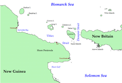
Bagabag island is in the upper left, next to Karkar Island NortheastNG Vitiaz Dampier.png
Bagabag island is in the upper left, next to Karkar Island

Bagabag is an island in the Madang Province of Papua New Guinea having a dormant volcano. [1]

Bagabag is 43 km (27 mi) east-north-east from Cape Croilles on the northern coast of the Papua New Guinea mainland, and is the closest island to Karkar Island which is 18 km (11 mi) to the north-west. The island is approximately circular in shape, with a diameter of about 7 km (4 mi). It has an area of 37 km2 (14 sq mi). The prominent feature of the coast is Christmas Bay, which cuts into the south-eastern side of the island. Volcanic in origin, terrain on Bagabaga consists of steep, thickly vegetated slopes that rise to over 600 m (2,000 ft) above sea level. Much of the northern, eastern and southern coasts are fringed by a barrier-type reef some 2 km (1.2 mi) offshore; the reef is narrow, and mostly submerged.

People from Karkar visit Bagabag by canoe. The island is rich in betel-nut, local pigs and garden food. The island supports four villages with a total population of about 3,000.

The first recorded sighting by Europeans of Karkar Island was by the Spanish navigator Iñigo Órtiz de Retes on 10 August 1545 when on board of the carrack San Juan tried to return from Tidore to New Spain. [2]

4°47′53″S146°13′59″E / 4.798°S 146.233°E / -4.798; 146.233

Related Research Articles

<span class="mw-page-title-main">Bismarck Archipelago</span> Archipelago in northeast Papua New Guinea

The Bismarck Archipelago is a group of islands off the northeastern coast of New Guinea in the western Pacific Ocean and is part of the Islands Region of Papua New Guinea. Its area is about 50,000 square kilometres (19,000 sq mi).

<span class="mw-page-title-main">Coral Sea</span> Marginal sea of the South Pacific off the northeast coast of Australia

The Coral Sea is a marginal sea of the South Pacific off the northeast coast of Australia, and classified as an interim Australian bioregion. The Coral Sea extends 2,000 kilometres (1,200 mi) down the Australian northeast coast. Most of it is protected by the French Natural Park of the Coral Sea and the Australian Coral Sea Marine Park. The sea was the location for the Battle of the Coral Sea, a major confrontation during World War II between the navies of the Empire of Japan, and the United States and Australia.

<span class="mw-page-title-main">Torres Strait</span> Navigable sea passage between Australia and New Guinea

The Torres Strait, also known as Zenadh Kes, is a strait between Australia and the Melanesian island of New Guinea. It is 150 km (93 mi) wide at its narrowest extent. To the south is Cape York Peninsula, the northernmost extremity of the Australian mainland. To the north is the Western Province of Papua New Guinea. It is named after the Spanish navigator Luís Vaz de Torres, who sailed through the strait in 1606.

<span class="mw-page-title-main">Biak Archipelago</span> Island group in Papua province, eastern Indonesia

The Biak Islands are an island group of Papua province, eastern Indonesia in the Cenderawasih Bay 50 km off the north-western coast of the island of New Guinea. The group consists of the main islands of Biak, Supiori and Numfor, and numerous smaller islands, mostly covered in rain forest. The population of the archipelago is about 130,000.

<span class="mw-page-title-main">Babeldaob</span> Largest island of Palau

Babeldaob is the largest island in the island nation of the Republic of Palau. It is in the western Caroline Islands, and the second largest island in the Micronesia region of Oceania. Palau's capital, Ngerulmud, is located on Babeldaob, in Melekeok State.

<span class="mw-page-title-main">Banda Sea</span> A sea between Sulawesi and Maluku

The Banda Sea is one of four seas that surround the Maluku Islands of Indonesia, connected to the Pacific Ocean, but surrounded by hundreds of islands, including Timor, as well as the Halmahera and Ceram Seas. It is about 1000 km (600 mi) east to west, and about 500 km (300 mi) north to south.

<span class="mw-page-title-main">Antoine Bruni d'Entrecasteaux</span> French naval officer, explorer and colonial governor

Antoine Raymond Joseph de Bruni, chevalier d'Entrecasteaux was a French naval officer, explorer and colonial governor. He is perhaps best known for his exploration of the Australian coast in 1792, while searching for the La Pérouse expedition. Antoine Bruni d'Entrecasteaux is commonly referred to simply as Bruni d'Entrecasteaux or Bruny d'Entrecasteaux, each of which is a compound surname.

<span class="mw-page-title-main">Bismarck Sea</span> Marginal sea of the Pacific Ocean

The Bismarck Sea lies in the south-western Pacific Ocean within the Papua New Guinean exclusive economic zone. It is located north-east of the island of New Guinea and south of the Bismarck Archipelago. It has coastlines in districts of the Islands Region, Momase Region, and Papua Region.

<span class="mw-page-title-main">D'Entrecasteaux Islands</span> Island group near New Guinea

D'Entrecasteaux Islands are situated near the eastern tip of New Guinea in the Solomon Sea in Milne Bay Province of Papua New Guinea. The group spans a distance of 160 km (99 mi), has a total land area of approximately 3,100 km2 (1,197 sq mi) and is separated from the Papua New Guinea mainland by the 30 km (19 mi) wide Ward Hunt Strait in the north and the 18 km (11 mi) wide Goschen Strait in the south. D'Entrecasteaux Islands show signs of volcanism.

<span class="mw-page-title-main">Karkar Island</span> Volcanic island in New Guinea

Karkar Island is an oval-shaped volcanic island located in the Bismarck Sea, about 30 kilometres (19 mi) off the north coast of mainland Papua New Guinea in Madang Province, from which it is separated by the Isumrud Strait. The island is about 25 km (16 mi) in length and 19 km (12 mi) in width. In the centre is an active volcano with two nested calderas.

<span class="mw-page-title-main">Guguan</span> Island in the Northern Marianas island chain

Guguan is an island in the Northern Mariana Islands in the Pacific Ocean. The island is currently uninhabited. Guguan is located 30 nautical miles (56 km) south from Alamagan and 250 nautical miles (463 km) north from Saipan, and is 67 nautical miles (124 km) northeast from Sarigan.

<span class="mw-page-title-main">Blup Blup</span> Island in Papua New Guinea

Blup Blup Island is a small forested island off the northern coast of Papua New Guinea about 30 km (19 mi) offshore from Cape Girgir and is considered part of the Schouten Islands. It is located at latitude S 3°30'46" and longitude E 144°35'16". The island has a small population and is theoretically part of the Papuan province of East Sepik, although officially it is still a protectorate.

<span class="mw-page-title-main">Rossel Island</span> Island in Papua New Guinea

Rossel Island is the easternmost island of the Louisiade Archipelago, within the Milne Bay Province of Papua New Guinea. Tree Islet is situated 1.5 miles to the north-west, while Wule Island is situated 1.5 miles westward.

<span class="mw-page-title-main">Simberi Island</span> Island of the Tabar Group of Papua New Guinea

Simberi Island is a volcanic island in the Tabar Group, in Papua New Guinea's New Ireland Province.

<span class="mw-page-title-main">Schouten Islands (Papua New Guinea)</span>

The Schouten Islands are a group of six small volcanic islands in the province of East Sepik in Papua New Guinea, north of the island of New Guinea. The group is also called Eastern Schouten Islands or Le Maire Islands to separate it from unrelated Schouten Islands in Indonesia. The combined land area is approximately 50 km2 (19 sq mi).

<span class="mw-page-title-main">Central Indo-Pacific</span> Biogeographic sea region

The Central Indo-Pacific is a biogeographic region of Earth's seas, comprising the tropical waters of the western Pacific Ocean, the eastern Indian Ocean, and the connecting seas.

<span class="mw-page-title-main">Pocklington Reef</span>

Pocklington Reef is a coral reef and a mostly submerged atoll in the far southeast of Papua New Guinea.

<span class="mw-page-title-main">New Guinea</span> Island in the Pacific Ocean

New Guinea is the world's second-largest island, with an area of 785,753 km2 (303,381 sq mi). Located in Melanesia in the southwestern Pacific Ocean, the island is separated from Australia by the 150-kilometre wide Torres Strait, though both landmasses lie on the same continental shelf, and were united during episodes of low sea level in the Pleistocene glaciations as the combined landmass of Sahul. Numerous smaller islands are located to the west and east. The island's name was given by Spanish explorer Yñigo Ortiz de Retez during his maritime expedition of 1545 due to the resemblance of the indigenous peoples of the island to those in the African region of Guinea.

<span class="mw-page-title-main">Bramble Cay</span> Island in Queensland, Australia

Bramble Cay, also known as Maizab Kaur and Massaramcoer, is a small cay located at the northeastern edge of Australia and the Torres Strait Islands of Queensland and at the northern end of the Great Barrier Reef. Lying around 50 km (31 mi) north of Erub Island in the Gulf of Papua, it is the northernmost point of land of Australia and marks the end of the Great Barrier Reef.

<span class="mw-page-title-main">Parama Island</span> Island in Papua New Guinea

Parama Island is an island close off the south coast of Papua New Guinea. It is located 17 km east of Daru, the provincial capital of Western Province, at the southernmost extreme of the Fly River delta, and at the northeastern corner of the Torres Strait. It is the northernmost of the Torres Strait Islands, and at the same time the southernmost of the Fly River delta. Bampton Point, its southernmost point, marks the southwestern corner of the Gulf of Papua. The Coral Sea is southeast. Torres Strait is south and southwest, specifically the Great Northeast Channel, which separates Parama Island from the closest Australian (Queensland) island, Bramble Cay, 48 km ESE.

References

  1. "Bagabag". Global Volcanism Program . Smithsonian Institution . Retrieved 13 September 2016.
  2. Coello, Francisco "Conflicto hispano-alemán" Boletín de Sociedad Geográfica de Madrid, t.XIX. 2º semestre 1885, Madrid, p.317.