
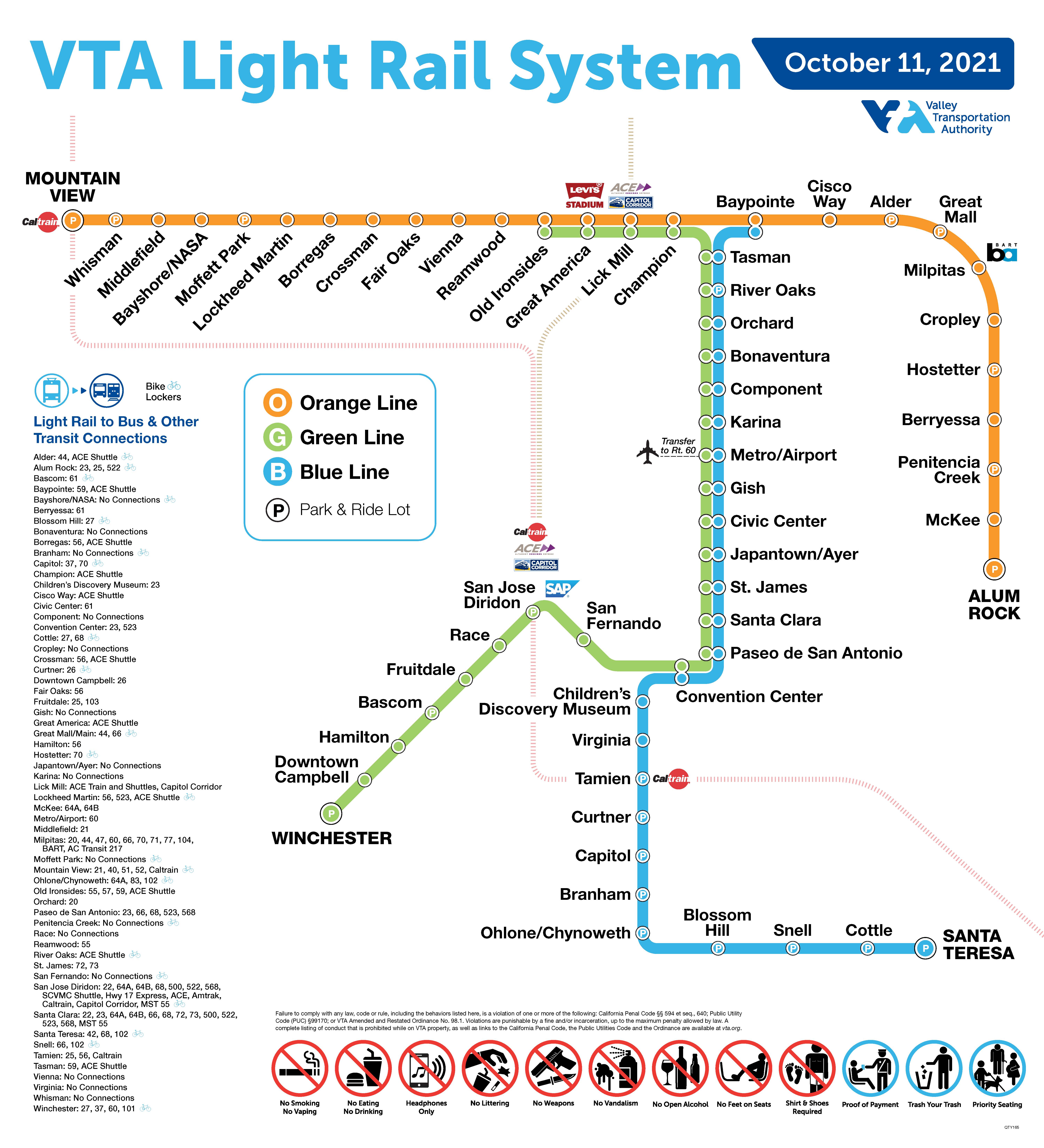
The Blue Line is a light rail line in Santa Clara County, California, and part of the Santa Clara Valley Transportation Authority (VTA) light rail system. It serves 26 stations entirely in San Jose proper, traveling between Baypointe and Santa Teresa stations, stopping at San Jose International Airport, Downtown San Jose, San Jose State University, and the Children's Discovery Museum of San Jose along the way. The line connects to Caltrain at Tamien. The Blue Line is one of three lines in the VTA light rail system; the other two being the Green Line and the Orange Line.

The Green Line is a light rail line in Santa Clara County, California, and part of the Santa Clara Valley Transportation Authority (VTA) light rail system. It serves 26 stations in the cities of Santa Clara, San Jose, and Campbell, traveling between Old Ironsides and Winchester stations. The line connects Levi's Stadium, San Jose International Airport, Downtown San Jose, San Jose State University, SAP Center, Diridon station, and Downtown Campbell. It runs for 20 hours per day on weekdays, with headways of 15 minutes for most of the day. On weekends, train run at 20 minute headways for most of the day. After around 8pm on weekdays and weekends trains run at 30 minute headways.

San Fernando station is a light rail station operated by Santa Clara Valley Transportation Authority. The station has two side platforms and two trackways. San Fernando station is served by the Green Line of the VTA light rail system.

Convention Center station is an at-grade light rail station on the Blue Line and the Green Line of the VTA light rail system. The station platform is located in the median of West San Carlos Street, between Almaden Boulevard and Market Street. The station is located across from the San Jose Convention Center, after which the station is named.
Paseo de San Antonio station is an at-grade light rail station on the Blue Line and the Green Line of the VTA light rail system. The station platforms run along the Downtown San Jose transit mall, with the northbound platform located alongside 1st Street and the southbound platform located alongside 2nd Street. The two platforms are connected by a pedestrian plaza, the Paseo de San Antonio, after which the station is named.

Santa Clara station is a light rail station operated by Santa Clara Valley Transportation Authority (VTA) located in the Historic District of Downtown San Jose, California on 1st and 2nd Streets just south of Santa Clara Street. The northbound platform is on 1st Street; the southbound platform is on 2nd Street. The platforms are connected via a pedestrian paseo called Fountain Alley. This station is served by the Blue and Green lines of the VTA light rail system.

River Oaks station is an at-grade light rail station located in the center median of First Street at its intersection with River Oaks Parkway, after which the station is named, in San Jose, California. The station is owned by Santa Clara Valley Transportation Authority (VTA) and is served by the Blue Line and the Green Line of the VTA light rail system.

Fruitdale station is a light rail station in the Fruitdale neighborhood of San Jose, California, operated by Santa Clara Valley Transportation Authority (VTA). The station has a center platform situated between two trackways. Fruitdale station is served by the Green Line of the VTA light rail system.

Bascom station is a light rail station operated by Santa Clara Valley Transportation Authority (VTA). The station has a single center platform between two tracks. Bascom station is served by the Green Line of the VTA light rail system.

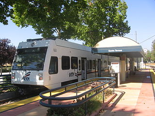
Hamilton station is an elevated light rail station located over East Hamilton Avenue, after which the station is named, near its intersection with Creekside Way and California State Route 17, in Campbell, California. The station is owned by Santa Clara Valley Transportation Authority (VTA) and is served by the Green Line of the VTA light rail system. The station has a single track used by trains traveling in both directions.

Winchester Transit Center is a light rail station and park-and-ride lot operated by Santa Clara Valley Transportation Authority (VTA) in Campbell, California. Winchester is the southern terminus of the Green Line of the VTA light rail system.

Baypointe station is an at-grade light rail station located in the center median of Tasman Drive at its intersection with Baypointe Parkway, after which the station is named, in San Jose, California. The station is owned by Santa Clara Valley Transportation Authority (VTA) and is served by the Blue Line and the Orange Line of the VTA light rail system. Baypointe station is the current northern terminus for the Blue Line.
Branham station is a light rail station operated by Santa Clara Valley Transportation Authority (VTA). The station is served by the Blue Line of the VTA light rail system and is connected to the Highway 87 bikeway. Branham station is located in the median of State Route 87, near Branham Lane in San Jose, California. It was part of the original Guadalupe Line, the first segment of light rail from Santa Teresa to Tasman.

Blossom Hill station is a light rail station operated by Santa Clara Valley Transportation Authority (VTA). The station is served by the Blue Line of the VTA light rail system. Blossom Hill station is located in the median of State Route 85, just north of Blossom Hill Road in San Jose, California. It was part of the original Guadalupe Line, the first segment of light rail from Santa Teresa to Tasman.

Snell station is a light rail station operated by Santa Clara Valley Transportation Authority (VTA). The station is served by the Blue Line of the VTA light rail system. It was part of the original Guadalupe Line, the first segment of light rail from Santa Teresa to Tasman. Snell station is located in the median of State Route 85, near Snell Avenue in the southern part of San Jose, California.
Cottle station is a light rail station operated by Santa Clara Valley Transportation Authority (VTA). The station is served by the Blue Line of the VTA light rail system. It was part of the original Guadalupe Line, the first segment of light rail from Santa Teresa to Tasman.
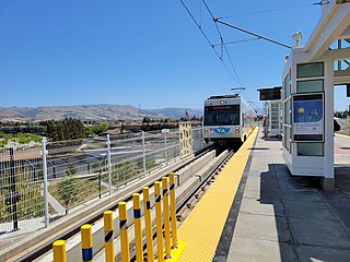
Santa Teresa station is a light rail station operated by Santa Clara Valley Transportation Authority (VTA). This station is the southern terminus of the Blue Line of the VTA light rail system. It was built in the late 1980s as part of the original Guadalupe Line, the first segment of light rail that stretched to Tasman in northern San Jose.

The VTA light rail system serves San Jose and nearby cities in Santa Clara County, California. It is operated by the Santa Clara Valley Transportation Authority (VTA) and has 42.2 miles (67.9 km) of network comprising three main lines on standard gauge tracks. Originally opened on December 11, 1987, the light rail system has expanded since then, and currently has 60 stations in operation.
The Orange Line is a light rail line in Santa Clara County, California, and part of the VTA light rail system. It serves 26 stations in the cities of Mountain View, Sunnyvale, Santa Clara, Milpitas, and San Jose, traveling between Downtown Mountain View and Alum Rock stations, stopping at Ames Research Center, Great America, and Levi's Stadium along the way. The line connects to Caltrain at Mountain View and to the Bay Area Rapid Transit (BART) system at Milpitas station. The line runs for 20 hours per day on weekdays, with headways of 15 minutes for most of the day. On weekends, the train runs at 20-minute headways for most of the day. After around 8 pm on weekdays and weekends trains run at 30-minute headways.

