Turkey Run State Park, Indiana's second state park, is in Parke County in the west-central part of the state along State Road 47, 2 miles (3.2 km) east of U.S. 41. The first parcel of land was purchased for $40,200 in 1916, when Indiana's state park system was established during the state's centennial anniversary of its statehood. The origin of the name "Turkey Run" is unknown, but the most accepted theory is that wild turkeys would congregate for warmth in the gorges, where early settlers could easily trap and hunt them. The Lusk Home and Mill Site and the Richard Lieber Log Cabin within the park's grounds were included as individual sites on the National Register of Historic Places in 1974 and 2001, respectively. The park itself was listed on the National Register of Historic Places in 2019. Turkey Run also includes a system of trails, Rocky Hollow Falls Canyon Nature Preserve, a suspension bridge across Sugar Creek, camping sites and other recreational areas. The Turkey Run Inn was built in 1919. Several guest cabins near the inn date from the 1930s and 1940s.
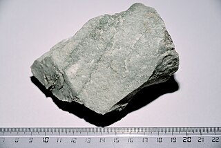
Quartzite is a hard, non-foliated metamorphic rock which was originally pure quartz sandstone. Sandstone is converted into quartzite through heating and pressure usually related to tectonic compression within orogenic belts. Pure quartzite is usually white to grey, though quartzites often occur in various shades of pink and red due to varying amounts of hematite. Other colors, such as yellow, green, blue and orange, are due to other minerals.

The Cannon River a tributary of the Mississippi River flows 112 miles (180 km) from Lake Tetonka near Waterville to Red Wing in the U.S. state of Minnesota, where it joins the Mississippi River. It drains a watershed approximately 1460 square miles (3,780 km²) in size. The river flows through the counties of Le Sueur, Rice, Dakota, and Goodhue.

Hocking Hills State Park is a state park in the Hocking Hills region of Hocking County, Ohio, United States; in some areas adjoining the Hocking State Forest. Within the park are over 25 miles of hiking trails, rock formations, waterfalls, and recess caves. The trails are open from dawn to dusk, all year round including holidays.

Rockbridge State Nature Preserve is a nature reserve featuring a natural bridge located in the unincorporated community of Rockbridge in Hocking County, Ohio, United States. It is part of the Hocking Hills region, but the sandstone that forms the natural bridge is located lower in the stratigraphic sequence than that which forms most of the region's notable features.
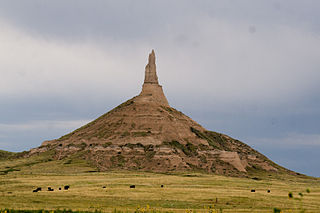
Chimney Rock is a prominent geological rock formation in Morrill County in western Nebraska. Rising nearly 300 feet (91 m) above the surrounding North Platte River valley, the peak of Chimney Rock is 4,228 feet (1,289 m) above sea level. The formation served as a landmark along the Oregon Trail, the California Trail, and the Mormon Trail during the mid-19th century. The trails ran along the north side of the rock, which remains a visible landmark for modern travelers along U.S. Route 26 and Nebraska Highway 92.

The Jeffers Petroglyphs site is an outcrop in southwestern Minnesota with pre-contact Native American petroglyphs. The petroglyphs are pecked into rock of the Red Rock Ridge, a 23-mile (37 km)-long Sioux quartzite outcrop that extends from Watonwan County, Minnesota to Brown County, Minnesota. The exposed surface is approximately 150 by 650 feet and surrounded by virgin prairie. "The site lies in an area inhabited in the early historic period by the Dakota Indians, and both the style and form of some of the carvings are identical with motifs that appear on Dakota hide paintings and their quill designs and beadwork. Others are foreign to this Plains Indian tradition and seem to be much earlier in origin." Several old wagon trail ruts traverse the site, one of which is believed to be the old stage coach route from New Ulm, Minnesota to Sioux Falls, South Dakota.
Chimney Rock can refer to one of the following sites in the United States and Canada:

Great River Bluffs State Park is a state park of Minnesota, United States, on the Mississippi River southeast of Winona. Originally known as O. L. Kipp State Park, it was renamed in the late 1990s to describe better its resources. The park preserves steep-sided bluffs rising 500 feet (150 m) above the river and the narrow valleys between them, which support rare and fragile plant communities. Two of the bluffs have received further protection under the Minnesota Scientific and Natural Areas program, which are known as King's and Queen's Bluff Scientific and Natural Area.

Buffalo River State Park is a state park of Minnesota, United States, conserving a prairie bisected by the wooded banks of the Buffalo River. Together with the adjacent Bluestem Prairie Scientific and Natural Area owned by The Nature Conservancy, it protects one of the largest and highest-quality prairie remnants in Minnesota. With the closest swimming lake to the Fargo–Moorhead metropolitan area, however, it is most popular for swimming and picnicking. The 1,068-acre (432 ha) park is located just off U.S. Route 10 in Clay County, 4.5 miles (7.2 km) east of Glyndon and 14 miles (23 km) east of Moorhead.

The geology of Minnesota comprises the rock, minerals, and soils of the U.S. state of Minnesota, including their formation, development, distribution, and condition.

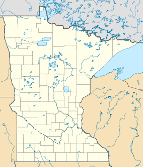
Minnesota is the northernmost state outside Alaska; its isolated Northwest Angle in Lake of the Woods is the only part of the 48 contiguous states lying north of the 49th parallel. Minnesota is in the U.S. region known as the Upper Midwest. The state shares a Lake Superior water border with Michigan and Wisconsin on the northeast; the remainder of the eastern border is with Wisconsin. Iowa is to the south, North Dakota and South Dakota are west, and the Canadian provinces of Ontario and Manitoba are north. With 87,014 square miles (225,370 km2), or approximately 2.26 % of the United States, Minnesota is the 12th largest state.

Nelson-Kennedy Ledges State Park is located in Nelson Township, Portage County, Ohio, United States. It is accessible from U.S. Route 422 and State Route 305 via State Route 282.

The Dakota Formation is a sedimentary geologic formation composed of sandstones, mudstones, and shales deposited in the late-Early to early-Late Cretaceous Western Interior Seaway. The unit is noted for being exceptionally widespread, producing massive colorful rock formations, and preserving dinosaur footprints and early deciduous tree leaves.

Lake Agassiz Peatlands Natural Area is a 25,411-acre (10,283 ha) National Natural Landmark located in Koochiching County, Minnesota. Designated in November 1965 under the Historic Sites Act, its ownership and oversight are provided by the National Park Service of the United States. This designation from the United States Secretary of the Interior, gives it recognition as an outstanding example of the nation's natural history. The designation describes it as
An example of the extensive peatlands occupying the bed of ancient glacial Lake Agassiz, illustrating the process of peat accumulation over about 11,000 years. The area contains Myrtle Lake Bog, which developed contrary to the usual successional process of lake filling, and is an excellent example of both raised and string bogs.

Dinosaur Ridge is a segment of the Dakota Hogback in the Morrison Fossil Area National Natural Landmark located in Jefferson County, Colorado, near the town of Morrison and just west of Denver.
The Rove Formation, is a sedimentary rock formation of Middle Precambrian age underlying the upper northeastern part of Cook County, Minnesota, United States, and extending into Ontario, Canada. It is the youngest of the many layers of sedimentary rocks which constitute the Animikie Group.
The Wisconsin State Natural Areas Program is a conservation program created to highlight and protect areas with outstanding natural or archaeological resources in the U.S. state of Wisconsin. There are currently 687 State Natural Areas (SNAs) encompassing almost 400,000 acres (160,000 ha). SNAs protect natural communities, geological formations, and archaeological sites for research purposes and as refuges for biodiversity and endangered or threatened species.
Paleontology in North Dakota refers to paleontological research occurring within or conducted by people from the U.S. state of North Dakota. During the early Paleozoic era most of North Dakota was covered by a sea home to brachiopods, corals, and fishes. The sea briefly left during the Silurian, but soon returned, until once more starting to withdraw during the Permian. By the Triassic some areas of the state were still under shallow seawater, but others were dry and hot. During the Jurassic subtropical forests covered the state. North Dakota was always at least partially under seawater during the Cretaceous. On land Sequoia grew. Later in the Cenozoic the local seas dried up and were replaced by subtropical swamps. Climate gradually cooled until the Ice Age, when glaciers entered the area and mammoths and mastodons roamed the local woodlands.
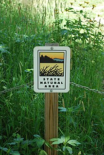
Minnesota Scientific and Natural Areas (SNAs) are public lands in the state of Minnesota that have been permanently protected to preserve any one or combination of the following: