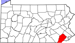
Devon-Berwyn, Pennsylvania

Last updated

Devon-Berwyn, Pennsylvania
USA Pennsylvania location map.svg
Red pog.svg
Devon-Berwyn, Pennsylvania
Location of Devon-Berwyn in Pennsylvania
Usa edcp location map.svg
Red pog.svg
Devon-Berwyn, Pennsylvania
Devon-Berwyn, Pennsylvania (the United States)
Coordinates: 40°02′37″N75°26′10″W / 40.04361°N 75.43611°W / 40.04361; -75.43611
CountryUnited States
StatePennsylvania
County Chester
Townships Easttown
Area
  Total2.5 sq mi (6 km2)
  Land2.5 sq mi (6 km2)
  Water0.0 sq mi (0 km2)
Elevation
492 ft (150 m)
Population
 (2000)
  Total5,067
  Density2,000/sq mi (780/km2)
Time zone UTC-5 (EST)
  Summer (DST) UTC-4 (EDT)
Area code(s) 610

Devon-Berwyn was a census-designated place (CDP) in Chester County, Pennsylvania. The population was 5,067 at the 2000 census. For the 2010 census, the area was split into two separate CDPs, Devon and Berwyn. The area is part of the Philadelphia Main Line suburbs of Philadelphia.

Contents

Devon-Berwyn was entirely in Easttown Township. [1] The two current CDPs of Devon and Berwyn are also in Easttown Township. [2]

Geography

Devon-Berwyn was located at 40°2′37″N75°26′10″W / 40.04361°N 75.43611°W / 40.04361; -75.43611 (40.043675, -75.436130). [3]

According to the U.S. Census Bureau, Devon-Berwyn had a total area of 2.5 square miles (6.5 km2), all of it land.

Demographics

As of the census of 2000, [4] there were 5,067 people, 1,978 households, and 1,307 families residing in the CDP. The population density was 2,028.1 inhabitants per square mile (783.1/km2). There were 2,035 housing units at an average density of 814.5 per square mile (314.5/km2). The racial makeup of the CDP was 92.26% White, 4.52% African American, 0.16% Native American, 2.39% Asian, 0.06% from other races, and 0.61% from two or more races. Hispanic or Latino of any race were 1.14% of the population.

There were 1,978 households; of those, 29.5% had children under the age of 18 living with them, 55.8% were married couples living together, 8.2% had a female householder with no husband present, and 33.9% were non-families. 29.4% of all households were made up of individuals, and 15.4% had someone living alone who was 65 years of age or older. The average household size was 2.40 and the average family size was 3.00.

In the CDP, the population was spread out, with 22.8% under the age of 18, 4.3% from 18 to 24, 27.2% from 25 to 44, 24.4% from 45 to 64, and 21.4% who were 65 years of age or older. The median age was 42 years. For every 100 females, there were 89.6 males. For every 100 females age 18 and over, there were 83.7 males.

The median income for a household in the CDP was $74,886, and the median income for a family was $87,228. Males had a median income of $62,241 versus $39,824 for females. The per capita income for the CDP was $35,551. About 1.0% of families and 4.3% of the population were below the poverty line, including 1.0% of those under age 18 and 6.1% of those age 65 or over.

Related Research Articles

<span class="mw-page-title-main">Mission Hills, Santa Barbara County, California</span> Census-designated place in the U.S. state of California

Mission Hills is a census-designated place (CDP) in Santa Barbara County, California, a short distance north of Lompoc on Highway 1. The population was 3,576 at the 2010 census, up from 3,142 at the 2000 census.

<span class="mw-page-title-main">Bridgeport, Michigan</span> Census-designated place & unincorporated community in Michigan, United States

Bridgeport is an unincorporated community in Bridgeport Charter Township, Saginaw County in the U.S. state of Michigan. It is also a census-designated place (CDP) for statistical purposes. The population was 6,571 at the 2020 census. Bridgeport is also the name of a post office with ZIP code 48722. The area served by the ZIP code includes the southeast portion of the CDP and includes southeastern portions of Bridgeport Charter Township outside of the CDP as well as portions of southwest Frankenmuth Township and a small area of northeastern Birch Run Township. The remainder of the CDP area is served by the Saginaw ZIP code 48601.

<span class="mw-page-title-main">Helena Valley West Central, Montana</span> Census-designated place in Montana, United States

Helena Valley West Central is a census-designated place (CDP) in Lewis and Clark County, Montana, United States. The population was 7,883 at the 2010 census. It is part of the Helena Micropolitan Statistical Area.

<span class="mw-page-title-main">West Hills, New York</span> Hamlet and census-designated place in New York, United States

West Hills is a hamlet and census-designated place (CDP) in the Town of Huntington, Suffolk County, New York. The population was 5,592 at the 2010 census. Residents share a post office with the hamlet of Huntington but much earlier in its history, West Hills had its own post office, located on Jericho Turnpike. Also, it is adjacent to the hamlet of Woodbury. It is considered part of the greater Huntington area, which is anchored by Huntington.

<span class="mw-page-title-main">Fairview, Westchester County, New York</span> CDP in New York, United States

Fairview is a hamlet and a census-designated place (CDP) located in the town of Greenburgh, Westchester County, New York, United States. The population was 3,099 at the 2010 census. As of 2000, Fairview had the fourth-highest percentage of African-Americans in New York.

Reiffton is a census-designated place (CDP) in Exeter Township, Berks County, Pennsylvania, United States. The population was 4,178 at the 2010 census.

Spring Ridge is a census-designated place (CDP) in Spring Township, Berks County, Pennsylvania, United States. The population was 1,003 at the 2010 census.

West Wyomissing is a census-designated place (CDP) in Spring Township, Berks County, Pennsylvania, United States. The population was 3,407 at the 2010 census.

<span class="mw-page-title-main">Richboro, Pennsylvania</span> Census-designated place in Pennsylvania, United States

Richboro is a census-designated place (CDP) in Northampton Township, Bucks County, Pennsylvania, United States. The population was 6,378 during the 2020 census.

<span class="mw-page-title-main">Chesterbrook, Pennsylvania</span> Census-designated place in Pennsylvania, United States

Chesterbrook is a census-designated place (CDP) in Chester County, Pennsylvania, United States. It is located within the Philadelphia metropolitan area and just south of Valley Forge National Historical Park. The population was 4,589 at the 2010 census.

<span class="mw-page-title-main">Easttown Township, Chester County, Pennsylvania</span> Township in Pennsylvania, United States

Easttown Township is a township in Chester County, Pennsylvania, United States. The population was 10,984 at the 2020 census. The township, which lies in the western half of Philadelphia's Main Line suburbs, is comprised predominantly of parts of two unincorporated areas: Devon and Berwyn. A small portion of the township has a Paoli address.

<span class="mw-page-title-main">Kenilworth, Pennsylvania</span> Census-designated place in Pennsylvania, United States

Kenilworth is a census-designated place (CDP) in North Coventry Township, Chester County, Pennsylvania, United States. The population was 2,148 at the 2020 census.

<span class="mw-page-title-main">Lionville, Pennsylvania</span> Census-designated place in Pennsylvania, United States

Lionville is a census-designated place (CDP) in Uwchlan Township, Chester County, Pennsylvania, United States. The population was 6,189 at the 2010 census. Prior to 2010 the CDP was recorded as Lionville-Marchwood. "Marchwood", however, refers only to the housing development begun in the early 1960s that is located south of the 100-113 intersection.

<span class="mw-page-title-main">Paoli, Pennsylvania</span> Census-designated place in Pennsylvania, United States

Paoli is a census-designated place (CDP) in Chester County near Philadelphia, Pennsylvania, United States. It is situated in portions of two townships: Tredyffrin and Willistown. At the 2020 census, it had a total population of 6,002.

<span class="mw-page-title-main">South Pottstown, Pennsylvania</span> Census-designated place in Pennsylvania, United States

South Pottstown is a community in North Coventry Township, Chester County in the U.S. state of Pennsylvania. It is defined by the U.S. Census Bureau as a census-designated place (CDP) for statistical purposes and does not have any legal status as a separately incorporated municipality. It is a part of the Pottstown urban area. The population was 2,081 at the 2010 census.

<span class="mw-page-title-main">Eagleville, Montgomery County, Pennsylvania</span> Census-designated place in Pennsylvania, United States

Eagleville is a census-designated place (CDP) in Montgomery County, Pennsylvania, United States. The population was 4,800 at the 2010 census. It is within Lower Providence Township.

<span class="mw-page-title-main">Trooper, Pennsylvania</span> Census-designated place in Pennsylvania, United States

Trooper is a census-designated place (CDP) in Lower Providence Township, Montgomery County, Pennsylvania, United States. The population was 5,744 at the 2010 census.

<span class="mw-page-title-main">St. Andrews, South Carolina</span> Census-designated place in South Carolina, United States

St. Andrews is a census-designated place (CDP) in Richland County, South Carolina, United States. The population was 20,493 at the 2010 census. It is part of the Columbia, South Carolina Metropolitan Statistical Area.

<span class="mw-page-title-main">Berwyn, Pennsylvania</span> Census-designated place in Pennsylvania, United States

Berwyn is a census-designated place (CDP) in Chester County, Pennsylvania, United States. Berwyn is located within Tredyffrin and Easttown Townships. The area is part of the Philadelphia Main Line suburbs.

<span class="mw-page-title-main">Devon, Pennsylvania</span> Census-designated place in Pennsylvania, United States

Devon is a census-designated place (CDP) located in Easttown township in Chester County, Pennsylvania, United States. The population was 1,515 at the 2010 census. The area is part of the Philadelphia Main Line suburbs.

References

  1. "CENSUS 2000 BLOCK MAP: DEVON−BERWYN CDP" (PDF). U.S. Census Bureau . Retrieved July 8, 2023.
    "CENSUS 2000 BLOCK MAP: EASTTOWN Township" (PDF). U.S. Census Bureau . Retrieved July 8, 2023. - Of the 1990 Census Maps: index page and pages 17, 24, and 25.
  2. "2020 CENSUS - CENSUS BLOCK MAP: Easttown township, PA" (PDF). U.S. Census Bureau . Retrieved July 8, 2023. - 2010 map
  3. "US Gazetteer files: 2010, 2000, and 1990". United States Census Bureau. February 12, 2011. Retrieved April 23, 2011.
  4. "U.S. Census website". United States Census Bureau . Retrieved January 31, 2008.