Edmonton City Centre (Blatchford Field) Airport

Last updated
Edmonton City Centre Airport
Blatchford Field
Edmonton City Centre (Blatchford Field) Airport (logo).svg
City Centre Airport Control Tower Edmonton Alberta Canada 01A.jpg
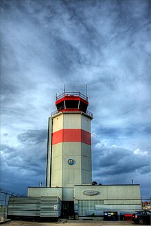
City Centre Airport control tower in 2010
Summary
Airport typePublic
OwnerCity of Edmonton
Operator Edmonton Airports
Serves Edmonton, Alberta, Canada
Opened1927
ClosedNovember 30, 2013 (2013-11-30)
Time zone MST (UTC−07:00)
  Summer (DST)MDT (UTC−06:00)
Elevation  AMSL 2,202 ft / 671 m
Coordinates 53°34′19″N113°31′10″W / 53.57194°N 113.51944°W / 53.57194; -113.51944 Coordinates: 53°34′19″N113°31′10″W / 53.57194°N 113.51944°W / 53.57194; -113.51944
Map
Edmonton agglomeration-blank.svg
Airplane silhouette.svg
YXD
Location within Edmonton
Runways
Direction LengthSurface
ftm
12/305,8701,789Asphalt
16/345,7001,737Asphalt
Statistics (2012)
Aircraft Movements55,863
Sources: Canada Flight Supplement [1]
Edmonton Airports [2]
Movements from Statistics Canada [3]

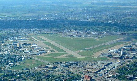
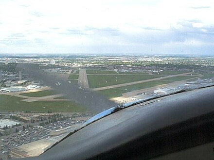
Edmonton City Centre Airport (ECCA), also called Blatchford Field, was an airport located within the city of Edmonton, in Alberta, Canada.

Airport location where aircraft take off and land

An airport is an aerodrome with extended facilities, mostly for commercial air transport. Airports often have facilities to store and maintain aircraft, and a control tower. An airport consists of a landing area, which comprises an aerially accessible open space including at least one operationally active surface such as a runway for a plane to take off or a helipad, and often includes adjacent utility buildings such as control towers, hangars and terminals. Larger airports may have airport aprons, taxiway bridges, air traffic control centres, passenger facilities such as restaurants and lounges, and emergency services. In some countries, the US in particular, they also typically have one or more fixed-base operators, serving general aviation.

Edmonton Provincial capital city in Alberta, Canada

Edmonton is the capital city of the Canadian province of Alberta. Edmonton is on the North Saskatchewan River and is the centre of the Edmonton Metropolitan Region, which is surrounded by Alberta's central region. The city anchors the north end of what Statistics Canada defines as the "Calgary–Edmonton Corridor".

Alberta Province of Canada

Alberta is a province of Canada. With an estimated population of 4,067,175 as of 2016 census, it is Canada's fourth most populous province and the most populous of Canada's three prairie provinces. Its area is about 660,000 square kilometres (250,000 sq mi). Alberta and its neighbour Saskatchewan were districts of the Northwest Territories until they were established as provinces on September 1, 1905. The premier is Jason Kenney as of April 30, 2019.

Contents

It was bordered by Yellowhead Trail to the north, Kingsway to the south, 121 Street to the west, and the Northern Alberta Institute of Technology (NAIT) and Jefferson armouries to the east. It encompassed approximately 144 acres (58 ha) of land just north of the city centre of Edmonton.

Alberta Highway 16 highway in Alberta

Alberta Provincial Highway No. 16, commonly referred to as Highway 16, is a major east–west highway in central Alberta, Canada, connecting Jasper to Lloydminster via Edmonton. It forms a portion of the Yellowhead Highway, a major interprovincial route of the Trans-Canada Highway system that stretches from Masset, British Columbia to Portage la Prairie, Manitoba, near Winnipeg. Highway 16 spans approximately 634 km (394 mi) from Alberta's border with British Columbia in the west to its border with Saskatchewan in the east. As of 2010, all but less than 96 km (60 mi) of the route was divided, with a minimum of two lanes in each direction. It is designated a core route in Canada's National Highway System.

The Northern Alberta Institute of Technology (NAIT) is a polytechnic and applied sciences institute in Edmonton, Alberta, Canada. NAIT provides careers programs in applied research, technical training, applied education, and learning designed to meet the demands of Alberta's technical and knowledge-based industries. NAIT offers approximately 120 credit programs leading to degrees, applied degrees, diplomas and certificates. As of 2018, there are approximately 16,000 students in credit programs 12,000 apprentices registered in apprenticeship training, 14,500 students enrolled in non-credit courses, and more than 20,000 registrants for customized corporate based training. NAIT also attracts international students from 94 countries. NAIT is similar to an Institute of technology or university of applied sciences as termed in other jurisdictions. The campus newspaper, the NAIT Nugget, is a member of the Canadian University Press (CUP).

The airport was originally called Blatchford Field, named for former mayor Kenneth Alexander Blatchford. It later was known as the Edmonton Municipal Airport, then as Edmonton Industrial Airport, [4] and then Edmonton City Centre Airport (ECCA), finally ending as Blatchford Field at Edmonton City Centre Airport. Over the years, the three letter code "YXD" ( IATA : YXD, ICAO : CYXD) continued to be used for the airport by all of the airlines serving the airfield.

Kenny Blatchford Canadian politician

Kenneth Alexander Blatchford was a Canadian politician who served as both mayor of Edmonton, Alberta and a member of the House of Commons of Canada.

An IATA airport code, also known as an IATA location identifier, IATA station code or simply a location identifier, is a three-letter code designating many airports and metropolitan areas around the world, defined by the International Air Transport Association (IATA). The characters prominently displayed on baggage tags attached at airport check-in desks are an example of a way these codes are used.

ICAO airport code four-letter code designating many airports around the world

The ICAOairport code or location indicator is a four-letter code designating aerodromes around the world. These codes, as defined by the International Civil Aviation Organization and published in ICAO Document 7910: Location Indicators, are used by air traffic control and airline operations such as flight planning.

The airport was closed in November 2013, and as of 2018, the land is being redeveloped by the City of Edmonton as a planned community called Blatchford.

Early history

The airport has a rich aviation history, being the first licensed airfield in Canada (1929). [5] Characters such as Wop May, a World War I fighter ace and bush pilot, helped pioneer aviation in Alberta and Northern Canada, further solidifying Blatchford Field as the "Gateway to the North".

Aviation Design, development, production, operation and use of aircraft

Aviation, or air transport, refers to the activities surrounding mechanical flight and the aircraft industry. Aircraft includes fixed-wing and rotary-wing types, morphable wings, wing-less lifting bodies, as well as lighter-than-air craft such as balloons and airships.

Northern Canada Region in Canada

Northern Canada, colloquially the North, is the vast northernmost region of Canada variously defined by geography and politics. Politically, the term refers to three territories of Canada: Yukon, Northwest Territories, and Nunavut. Similarly, the Far North may refer to the Canadian Arctic: the portion of Canada that lies north of the Arctic Circle, east of Alaska and west of Greenland. This area covers about 39 percent of Canada's total land area, but has less than 1 percent of Canada's population.

Along with May, the Mayor of Edmonton, Kenny Blatchford, had played a key role in establishing the airport in 1927. [6] Blatchford's son, Howard Peter Blatchford, became a fighter ace in WWII.

Wiley Post landed at the airport during both of his circumnavigations.

RCAF Station Edmonton

The airport served as a military airbase during World War II, when it was a major stop-over on the Northwest Staging Route and hosted two British Commonwealth Air Training Plan schools.

No. 2 Air Observer School (AOS), operated by Canadian Airways and Canadian Pacific Airlines, opened at RCAF Station Edmonton on August 5, 1940. Later that year, on November 11, the Royal Canadian Air Force (RCAF) established No. 16 Elementary Flying Training School (EFTS), operated by the Edmonton Flying Club; this school was closed on July 17, 1942 to allow for an expansion of No. 2 Air Observer School. Upon winding down of the British Commonwealth Air Training Plan, No. 2 AOS was closed on July 14, 1944. [7]

During this period, in about 1942, the aerodrome was listed at 53°34′N113°31′W / 53.567°N 113.517°W / 53.567; -113.517 with a Var. 25 degrees E and elevation of 2,185 feet (666 m). The facility was listed as being a Department of Transport and RCAF Aerodrome and had three runways, listed as follows: [8]

Runway NameLengthWidthSurface
3/214,500 feet (1,372 m)200 feet (61 m)Hard surfaced
11/295,700 feet (1,737 m)200 feet (61 m)Hard surfaced
15/335,700 feet (1,737 m)200 feet (61 m)Hard surfaced

Weather

A weather station was established in 1937. [9] Over the years since then, its site witnessed increasing influence by the urban heat island effect.

By the mid-1970s, "Edmonton Municipal A." (as it was listed in the Monthly Record of Meteorological Observations in Canada) was regularly recording some of the longest frost-free periods in the Prairie Provinces, with the first fall frost often not coming before October.[ citation needed ]

Scheduled passenger service

1950s and 1960s

In 1950, the airport was a stop on an international route operated by Northwest Airlines between the U.S. and Asia. [10] According to the September 24, 1950 Northwest Airlines system timetable, the air carrier was operating Douglas DC-4 propliner service on a routing of New York City - Washington, D.C. - Chicago - Minneapolis/St. Paul - Edmonton - Anchorage - Tokyo four days a week with continuing service to Okinawa and Manila or Taipei depending on the day of the week. By the late 1950s, three Canadian-based airlines were providing primary scheduled passenger air service at the airport: major air carriers Canadian Pacific Air Lines (which would become CP Air) and Trans-Canada Air Lines (TCA, which would become Air Canada) as well as regional air carrier Pacific Western Airlines (PWA). In 1959, Canadian Pacific was operating international service to Europe with four nonstop flights a week flown with Douglas DC-6B "Empress" propliners between Edmonton and Amsterdam with these flights originating and terminating in Vancouver and was also operating local domestic service with Convair 240 prop aircraft to Grande Prairie, Alberta and Fort St. John, British Columbia. [11] A year earlier in 1958, Trans-Canada was flying Lockheed L-1049 Super Constellation and Canadair North Star (a Canadian produced version of the Douglas DC-4) propliners in addition to Vickers Viscount turboprops on nonstop services to Vancouver, Toronto, Winnipeg and Saskatoon as well as direct, no change of plane flights to Montreal. [12] According to the June 1, 1958 Trans-Canada Air Lines system timetable, the air carrier was also operating five nonstop departures a day to Calgary with Viscount propjets. Pacific Western was operating regional services from the airport in 1959 with Curtiss C-46 and Douglas DC-4 prop aircraft to a number of Canadian destinations located north of Edmonton including Fort McMurray, Fort Smith, Fort Resolution, Fort Vermilion, Hay River, Inuvik, Norman Wells, Peace River, Uranium City, and Yellowknife. [13]

By 1964, Pacific Western had expanded its domestic service from the airport with the addition of regional flights to Cambridge Bay, Coppermine, Dawson Creek, Fort Simpson and Wrigley as well as to the Resolute Bay Airport in the Arctic which is the northernmost destination in Canada served by scheduled airline flights. [14] By 1968, Pacific Western had introduced Convair 640 turboprop aircraft (which the airline called the "Javelin Jet-Prop") on many of its flights from the airport and had also introduced its "Chieftain Airbus" shuttle service linking Edmonton and Calgary operated with Douglas DC-6 propliners with six round trip nonstop flights a day between the two cities. [15] According to the June 24, 1968 Pacific Western system timetable, Douglas DC-6 and DC-6B passenger aircraft as well as all-cargo DC-4 aircraft were also being operated by the airline to destinations located north of Edmonton. The jet age arrived at the airport in 1969 when Pacific Western introduced Boeing 737-200 jetliners with nonstop flights to Calgary, Fort Smith and Hay River with direct, no change of plane 737 jet service to Vancouver, Yellowknife, Kamloops, Kelowna, Cranbrook, Penticton, Inuvik and Norman Wells. [16]

1970s and 1980s

Edmonton City Centre Airport Edmonton City Centre Airport.jpg
Edmonton City Centre Airport

Several types of jet passenger aircraft were operated into ECCA, notably the Boeing 737-200. As noted above, these 737 flights were initially operated by Pacific Western Airlines [4] followed by its successor Canadian Airlines (formerly CP Air) from the initial purchase of these aircraft in the late 1960s up until the merger of Pacific Western with Canadian with the latter continuing to operate 737 flights into the airport. Pacific Western flew its "Chieftain Airbus" shuttle service between the airport and Calgary (YYC) for many years with the 737 and in 1976 was operating up to fourteen Boeing 737-200 departures a day nonstop from ECCA to YYC in addition to operating direct 737 jet flights into the airport from Castlegar, BC, Cranbrook, BC, Dawson Creek, BC, Fort Chipewyan, AB, High Level, AB, Kamloops, BC, Kelowna, BC, Peace River, AB, Penticton, BC, Prince George, BC, Uranium City, SK and Vancouver, BC. [4] The runway lengths at ECCA mandated the absolute maximum performance characteristics of the Boeing 737-200 jetliner due to its weight; however, the extreme wear caused by utilising this airfield and pushing these limits was a concern. Other jet service came in the form of the British Aerospace BAe 146-200 as Air Canada Connector flights operated by Air BC on behalf of Air Canada. McDonnell Douglas DC-9-30 jets in Air Canada livery operated briefly out of ECCA in the mid 1980s but left due to field/weight limitations. Time Air and its later brand of Canadian Regional operated Fokker F28 Fellowship twin jets, while Echo Bay Mines Limited operated a private passenger/cargo Boeing 727-100 combi aircraft trijet from the field for several years. Time Air previously operated Fokker F27 Friendship, de Havilland Canada DHC-6 Twin Otter and Short 330 turboprop aircraft from the airfield during the 1970s [4] as well as Convair 580, Convair 640, de Havilland Canada DHC-7 Dash 7 and de Havilland Canada DHC-8 Dash 8 turboprops during the 1980s. [17] Both the Twin Otter and Dash 7 have short takeoff and landing (STOL) capabilities so runway length was not an issue for these particular aircraft types. Besides operating flights with 737 jets, Pacific Western also operated Lockheed L-188 Electra turboprop service from the airport during the mid 1970s with nonstop flights to Fort Chipewyan, Fort McMurray and Peace River in Alberta province as well as direct to Fort Smith, NWT and Yellowknife, NWT. [18]

By early 1985, Pacific Western was operating eighteen nonstop Boeing 737-200 flights every weekday from the airport to Calgary via its "Chieftain Airbus" shuttle schedule linking the two cities. [19] [ failed verification ] There were also two other airlines competing with Pacific Western at this time on the Edmonton (YXD) - Calgary (YYC) nonstop route: Air Canada operating McDonnell Douglas DC-9-30 jets with two flights on weekdays and Time Air operating de Havilland Canada DHC-7 Dash 7 turboprops with three flights on weekdays for a combined total of 23 flights every weekday operated by the three airlines. [20] [ failed verification ] In contrast, there were only four nonstop jet flights every weekday from Calgary (YYC) to Edmonton International Airport (YEG) at this same time in 1985: one flight each respectively operated by Air Canada and CP Air and two flights operated by Pacific Western. [21] [ failed verification ] Also in contrast at this same time, there was only one nonstop flight a day operated on the weekdays from Edmonton International to Calgary with this service being flown by CP Air. [20] [ failed verification ] Other airlines serving ECCA as this time were Norcanair with Fairchild F-27 turboprop service nonstop from Lloydminster and direct from Saskatoon, and Southern Frontier Airlines with nonstop Beechcraft 99 commuter turboprop service from Cold Lake, AB. [22] [ failed verification ] According to the April 28, 1985 Pacific Western system timetable, in addition to its nonstop flights to Calgary the airline was operating direct, no change of plane 737 jet service from the airport to the Canadian destinations of Vancouver, Toronto, Winnipeg, Regina, Saskatoon, Cranbrook, BC, Fort McMurray, Kamloops, Kelowna and Penticton. [23] [ failed verification ] Pacific Western had become an all-jet air carrier with a fleet of 737 aircraft at this time. Time Air was also operating nonstop flights into the airport from other locations besides Calgary in 1985 including Grande Prairie, Alberta and Peace River, Alberta with these services being flown with Convair 640 turboprops as well as with the Dash 7. [22] [ failed verification ]

The airport also had service to the U.S. during the mid 1980s. In 1985, Pacific Western was operating direct, no change of plane Boeing 737-200 jet service to Seattle via intermediate stops at Calgary and Vancouver. [24] In 1987, Continental Airlines in conjunction with Pacific Western was operating two flights a day to Texas with direct service to Dallas/Fort Worth (DFW) and Houston (IAH). Pacific Western operated the Edmonton-Calgary portion of the service with Boeing 737-200s and passengers then transferred to Continental operated Boeing 727-100 jetliners in Calgary for the flights to Texas. [25] According to the February 1, 1987 Continental timetable, the respective routings of these flights were YXD-YYC-DFW-IAH and YXD-YYC-IAH, and both services were operated with Continental flight numbers. [25]

1990s

By 1995, three different airlines were operating a combined total of up to 32 nonstop flights a day from the airport to Calgary according to the Official Airline Guide (OAG). [26] Canadian Airlines International was operating flights between ECCA and Calgary with Boeing 737-200 jetliners while Time Air flying as Canadian Partner on behalf of Canadian via a code sharing agreement was operating Fokker F28 jets and de Havilland Canada DHC-8 Dash 8 turboprops. Air BC operating as Air Canada Connector on behalf of Air Canada via a code sharing agreement was flying British Aerospace BAe 146-200 jets and de Havilland Canada DHC-8 Dash 8 turboprops on the route at this same time.

Final years (2000–2013)

Overlay of the pre-2011 Edmonton IndyCar track on an airport map Edmonton City Airport map with the racing road course map overlaid.png
Overlay of the pre-2011 Edmonton IndyCar track on an airport map

In its final years, before closing in 2013, the airport was mainly used for air charter, general aviation, flight training and medivac (air ambulance). [27]

In addition, from 2005 to 2012, the airport was annually converted into a speedway for the Edmonton Indy Champ Car race. In 2008 Champ Car merged with the Indy Racing League, and became the IndyCar Series. The NASCAR Canadian Tire Series also raced at the speedway in 2007, 2008, 2009, 2010, and 2012. Beginning with the July 2011 event, the track layout was reconfigured to use a more northeasterly section of the airport, including Runway 16/34 (which had been permanently closed). [28] [29]

Obsolescence and closure

Debate

The fate of the Edmonton City Centre Airport (ECCA) was fiercely debated for decades, beginning in the 1950s.

To accommodate demands for ever-increasing range, new generations of jet aircraft became increasingly larger and heavier, resulting in the need for a longer set of runways. It became clear that it would be economically and in many cases physically impossible to accommodate modern jet aircraft at ECCA. With no ability to expand the runways, a search began for a site for construction of a new international airport. Edmonton entered into fifty years of airport debates shaped by issues of logistics, transportation, and regional disparities.

To the north of the city, a World War II military base (now CFB Edmonton) had been built at Namao by the United States Army Air Forces. In the 1950s, the base was expanded to handle Strategic Air Command military bomber aircraft, including the longest runway in Canada.

Leduc, Alberta, located 14  NM (26 km; 16 mi) south by southwest of downtown Edmonton, [1] was chosen as the site for the Edmonton International Airport ( IATA : YEG, ICAO : CYEG).

It was initially decided that ECCA would be closed in 1963, upon completion of a new passenger terminal at Edmonton International. However, the issue was reexamined by consultants, [30] and particularly in view of the unforeseen development of regional airliner service at ECCA, especially to Calgary, the City of Edmonton decided to keep ECCA open and operate both airports.

In Edmonton's 1992 municipal election, the City of Edmonton held a plebiscite, the Edmonton Municipal Airport Referendum. The result of the referendum was that Bylaw No. 10,205, which kept ECCA open to all traffic that the field could legally handle, was approved with a vote of 54%.

In the 1995 election, a second plebiscite was put forth to the citizens of Edmonton asking if the bylaw should be repealed on the basis of consolidating all scheduled traffic at Edmonton International. Determination of whether or not to close the airport was not given as an option. 77% of voters approved the proposed version, and in June 1996, the consolidation process was finalized.

Closure

On July 8, 2009, the city council decided on a phased closure of the airport. The Alberta Aviation Museum and some non-aviation institutions were to remain, with some land transferred to Northern Alberta Institute of Technology, and the rest converted to a primarily residential development. [31]

The north-south runway, Runway 16/34, was to be the first runway closed. The closure was postponed until after the Indy and Airfest events of 2010. [32] On August 3, 2010, Runway 16/34 was closed to air traffic with a Notice to Airmen being issued at 3:00 am that morning. [33]

Closure of the remaining runway, Runway 12/30, was announced at an Edmonton City Council meeting on September 26, 2013. Licenses for scheduled air service were not renewed.

On the afternoon of November 30, 2013, the last airplane to leave the airfield was a Cessna 172, owned and piloted by a local. Weather prevented a pair of CF-18 fighter jets from performing a touch-and-go landing as the ceremonial last takeoff. [34] Shortly afterwards, ERAA placed barricades on Runway 12/30 to prevent access, and markers were placed to clearly signal to pilots that it was closed. [35]

On February 21, 2015, a Pipistrel Virus aircraft C-FCDZ flying over the site of the airport suffered a propeller failure, resulting in an unplanned landing on the airport grounds using the plane's ballistic parachute. [36]

Blatchford community

As of 2018, 525 acres of the former Blatchford Field is undergoing redevelopment into a medium and high density neighbourhood. [37]

The Blatchford area will be broken into five boroughs: Blatchford West, Blatchford East, Blatchford Park, Civic Plaza, and Town Centre. [38] Blatchford West, the first borough to be developed, will have more than 6,000 townhouses and apartments, while Blatchford East will have more than 4,000 townhouses and apartments. [38] Blatchford Park will be around 120 acres in size and will include a large lake. [38] The Town Centre and Civic Plaza will accommodate various businesses, markets, shops, and an LRT light rail transit station. [38]

Airport facilities (historical)

On approach, runway 30 YXD Approach.JPG
On approach, runway 30

Airfield and runways

The field elevation was 2,202 ft (671 m).

Due to the airport's location in the central portion of the city, there were both curfew restrictions and noise abatement procedures. The field maintained 24 X 7 operations, with the strictest noise regulations in effect from 22:00h to 07:00h local time.

Facilities and amenities

For private and corporate aviation, there were two fixed-base operators (FBO) on site, located on the west side of the airfield off Taxiway A.

On-site amenities included the Alberta Aviation Museum, two hotels, and a cafeteria in the Edmonton Flying Club's building.

A flight school was operated at Centennial Flight Centre. [36]

Private air ambulances used the Esso Avitat hangar to store their ground support units. A STARS air ambulance was also based at the airport.

Further amenities located close to the airport included shopping at Kingsway Mall, lodging at the Chateau Louis hotel, and a Via Rail train station to the north, off Bush Pilot Road. The Alberta and Edmonton office for St. John Ambulance was located nearby. Proximity to the Royal Alexandra Hospital provided a link for emergency medical access by air to many of Alberta's rural communities.

Accidents and incidents

Four flights originating at the airport ended in fatal crashes:

See also

Related Research Articles

Owen Roberts International Airport airport

Owen Roberts International Airport is an airport serving Grand Cayman, Cayman Islands. It is the main international airport for the Cayman Islands as well as the main base for Cayman Airways. The airport is named after British Royal Air Force (RAF) Wing Commander Owen Roberts, a pioneer of commercial aviation in the country, and is one of the two entrance ports to the Cayman Islands.

Edmonton International Airport international airport serving Edmonton, Alberta, Canada

Edmonton International Airport is the primary air passenger and air cargo facility in the Edmonton Metropolitan Region of the Canadian province of Alberta. Operated by Edmonton Airports, it is located 14 nautical miles south southwest of Downtown Edmonton in Leduc County on Highway 2 opposite of the city of Leduc. The airport offers scheduled non-stop flights to major cities in Canada, the United States, Mexico, the Caribbean, Central America and Europe.

Winnipeg James Armstrong Richardson International Airport international airport serving Winnipeg, Canada

Winnipeg James Armstrong Richardson International Airport is an international airport located in Winnipeg, Manitoba, Canada. It is the seventh busiest airport in Canada by passenger traffic, serving 4,305,744 passengers in 2017, and the 11th busiest airport by aircraft movements. It is a hub for passenger airlines Calm Air, Perimeter Airlines, Flair Airlines, and cargo airline Cargojet. It is also a focus city for WestJet. The airport is co-located with Canadian Forces Base Winnipeg.

Pacific Western Airlines Ltd (PWA) was an airline that operated scheduled flights throughout western Canada and charter services around the world from the 1950s through the 1980s.

Charlottetown Airport airport

Charlottetown Airport,, is located 3 nautical miles north of Charlottetown, Prince Edward Island, Canada. The airport is currently run by the Charlottetown Airport Authority, is owned by Transport Canada and forms part of the National Airports System.

Thunder Bay International Airport Airport in Thunder Bay, Ontario, Canada

Thunder Bay International Airport,, is an airport in the city of Thunder Bay, Ontario, Canada. With 108,130 aircraft movements in 2012, it was the fourth busiest airport in Ontario and the 16th busiest airport in Canada. During the same year, more than 761,000 passengers went through the airport.

Nordair former Canadian airline, acquired by Canadian Airlines (Q627115)

Nordair was a Quebec-based airline in Canada founded in 1947 from the merger of Boreal Airways and Mont Laurier Aviation.

Billings Logan International Airport Public airport in Billings, Montana, United States

Billings Logan International Airport is two miles northwest of downtown Billings, in Yellowstone County, Montana. It is the second largest airport in Montana, having been surpassed by Bozeman in both number of gates as well as annual enplanements in recent years, and is owned by the city of Billings. The airport is on top of the Rims, a 500-foot (150 m) cliff overlooking the downtown core. BIL covers 2,300 acres (9.3 km2.) of land.

Prince George Airport commercial airport serving Prince George, British Columbia, Canada

Prince George Airport is an airport that serves Prince George, British Columbia, Canada, and the surrounding area. It is located just within the southern boundary of the city, 2.8 nautical miles southeast, and is run by the Prince George Airport Authority.

Time Air airline in Canada

Time Air was an airline in Canada founded in 1966 by businessman Walter “Stubb” Ross from Lethbridge in Alberta. It was called "Lethbridge Air Service" before becoming Time Airways Ltd. which was then shortened to Time Air Ltd. In 1993 it was merged with Ontario Express to create Canadian Regional Airlines.

Kelowna International Airport international airport in British Columbia, Canada

Kelowna International Airport is a Canadian airport located approximately 10 minutes or 6.2 nautical miles northeast of Kelowna, British Columbia, Canada, on Highway 97.

Lethbridge Airport airport in Canada

Lethbridge Airport, previously Lethbridge County Airport, is located 4 nautical miles south southeast of Lethbridge, Alberta, Canada. It is 10–15 driving minutes from downtown and has scheduled service to the city of Calgary, Alberta. The airport is classified as an airport of entry by Nav Canada and is staffed by the Canada Border Services Agency (CBSA) on a call-out basis from the Sweetgrass-Coutts Border Crossing. CBSA officers at this airport can handle general aviation aircraft only, with no more than 15 passengers. The airport hosts the biennial Lethbridge International Airshow.

Erik Nielsen Whitehorse International Airport airport

Erik Nielsen Whitehorse International Airport is an international airport located in Whitehorse, Yukon, Canada. It is part of the National Airports System, and is owned and operated by the Government of Yukon. The airport was renamed in honour of longtime Yukon Member of Parliament Erik Nielsen on December 15, 2008. The terminal handled 294,000 passengers in 2012, representing a 94% increase in passenger traffic since 2002. By 2017, this number had risen to 366,000. Air North is based in Whitehorse.

Resolute Bay Airport airport in Resolute, Nunavut, Canada

Resolute Bay Airport is located at Resolute, Nunavut, Canada, and is operated by the government of Nunavut. It is one of the northernmost airfields in Canada to receive scheduled passenger airline service.

Casper–Natrona County International Airport airport

Casper–Natrona County International Airport is 7 miles (11 km) northwest of Casper, in Natrona County, Wyoming. Before December 19, 2007 the airport was called Natrona County International Airport.

Idaho Falls Regional Airport airport in Idaho, United States of America

Idaho Falls Regional Airport is a city-owned, public-use airport located two nautical miles (4 km) northwest of the central business district of Idaho Falls, a city in Bonneville County, Idaho, United States. It was formerly known as Fanning Field. It is the second-busiest airport in Idaho after Boise Airport.

Juneau International Airport

Juneau International Airport is a city-owned, public-use airport and seaplane base located seven nautical miles northwest of the central business district of Juneau, a city and borough in the U.S. state of Alaska that has no direct road access to the outside world. The airport serves as a regional hub for all air travel, from bush carriers to a major U.S. air carrier, Alaska Airlines.

CFB Comox airport in British Columbia, Canada

Canadian Forces Base Comox, commonly referred to as CFB Comox or 19 Wing is a Canadian Forces Base located 2.5 nautical miles north northeast of Comox, British Columbia. It is primarily operated as an air force base by the Royal Canadian Air Force (RCAF) and is one of two bases in the country using the CP-140 Aurora anti-submarine/maritime patrol and surveillance aircraft. Its primary RCAF lodger unit is 19 Wing, commonly referred to as 19 Wing Comox.

Providenciales International Airport international airport serving on Providenciales, Turks and Caicos Islands

Providenciales International Airport, on the island of Providenciales in the Caicos Islands, is the main international airport serving the Turks and Caicos Islands, a British Overseas Territory of the United Kingdom. It is operated by Turks and Caicos Islands Airports Authority (TCIAA). The territory's other international airport is JAGS McCartney International Airport on Grand Turk Island. Currently, there are more than 12,000 commercial aircraft operations per year.

Fort Nelson Airport airport

Northern Rockies Regional Airport, , is located 3.8 nautical miles east northeast of Fort Nelson, British Columbia, Canada.

References

  1. 1 2 Canada Flight Supplement. Effective 0901Z 20 June 2019 to 0901Z 15 August 2019.
  2. "2008 Annual Report and Financials" (PDF). Archived from the original (PDF) on July 11, 2011.
  3. Canada, Government of Canada, Statistics. "Aircraft Movement Statistics: NAV CANADA Towers and Flight Service Stations: Annual Report (TP 577): Table 2-1 — Total aircraft movements by class of operation — NAV CANADA towers". www.statcan.gc.ca.
  4. 1 2 3 4 February 1, 1976 Official Airline Guide (OAG), Edmonton (YXD) flight schedules.
  5. City of Edmonton. "Population, Historical" (PDF). City of Edmonton. Retrieved February 26, 2007.
  6. "Aviation Museum celebrates Blatchford Field's 90th". June 24, 2017.
  7. Hatch, F. J. (1983). The Aerodrome of Democracy: Canada and the British Commonwealth Air Training Plan, 1939-1945. Ottawa: Directorate of History, Department of National Defence. ISBN   0660114437.
  8. Staff writer (c. 1942). Pilots Handbook of Aerodromes and Seaplane Bases Vol. 2. Royal Canadian Air Force. p. 90.
  9. Thomas, Morley K. Metmen in Wartime: Meteorology in Canada 1939-1945. p. 137.
  10. http://www.timetableimages.com, Sept. 24, 1950 Northwest Airlines system timetable
  11. "Canadian Pacific Air Lines". Airline Timetable Images. July 1959. Archived from the original on December 15, 2017.
  12. "Trans-Canada Air Lines". Airline Timetable Images. June 1, 1958.
  13. "Pacific Western Airlines". Airline Timetable Images. September 24, 1959.
  14. "Pacific Western Airlines". Airline Timetable Images. April 26, 1964.
  15. "Pacific Western Airlines". Airline Timetable Images. June 24, 1968.
  16. "Pacific Western Airlines". Airline Timetable Images. September 28, 1969.
  17. "Official Airline Guide (OAG), Edmonton (YXD) schedules". Departed Flights. April 1, 1981.
  18. "Official Airline Guide (OAG), Edmonton Industrial Airport flight schedules". Departed Flights. April 15, 1975.
  19. http://www.departedflights.com, Feb. 15, 1985 Official Airline Guide (OAG), Calgary flight schedules (OAG)
  20. 1 2 http://www.departedflights.com, Feb. 15, 1985 Official Airline Guide (OAG), Calgary flight schedules
  21. http://www.departedflights.com, Feb. 15, 1985 Official Airline Guide (OAG), Edmonton International Airport flight schedules
  22. 1 2 http://www.departedflights.com, Feb. 15, 1985 Official Airline Guide (OAG), Edmonton Municipal Airport flight schedules
  23. http://www.departedflights.com, April 28, 1985 Pacific Western Airlines system timetable
  24. "Pacific Western Airlines system timetable, Edmonton Municipal Airport flight schedules". Departed Flights. April 28, 1985.
  25. 1 2 "Continental Airlines – February 1, 1987 Employee System Timetable". Departed Flights (Edmonton (YXD) flight schedules). pp. 25–26. Archived from the original on May 31, 2017.
  26. "Official Airline Guide (OAG), Edmonton Municipal-Calgary flight schedules". Departed Flights. April 2, 1995.
  27. "ECCA – Edmonton City Centre Airport". Archived from the original on January 6, 2009.
  28. Klinkenberg, Marty; Klingbeil, Cailynn (September 21, 2012). "End of the line for Edmonton Indy". Edmonton Journal. Archived from the original on August 23, 2017.
  29. "Edmonton Indy – Edmonton City Centre Airport". INDYCAR Series. Edmonton, Alberta. 2012. Archived from the original on August 6, 2017.
  30. Fisher Report 1962, Edmonton City Archives.
  31. "City Centre Redevelopment". Archived from the original on October 16, 2012.
  32. Liebrecht, Richard (October 1, 2009). "Airport closure prolonged: Council moves to delay shutting down City Centre's runway until after the 2010 Rexall Indy and Airfest". Edmonton Sun. Archived from the original on February 23, 2012.CS1 maint: Unfit url (link)
  33. Gavriloff, Brian (August 4, 2010). "Edmonton City Centre Airport down to one runway". Edmonton Journal. Archived from the original on August 5, 2010. Retrieved August 4, 2010.
  34. Theobald, Claire (December 3, 2013). "Local pilot becomes the last person to take off from Edmonton City Centre Airport After weather grounds special fly-by of CF-18s". Edmonton Examiner. Retrieved December 9, 2013.
  35. Ramsay, Caley (November 30, 2013). "Day of mixed emotions as Edmonton's City Centre Airport closes for good". Global Edmonton.
  36. 1 2 Ramsay, Caley (February 21, 2015). "'I'm just happy to be in one piece': pilot of small airplane forced to make emergency landing in Edmonton". Global News. Canada. Archived from the original on October 27, 2016.
  37. "Blatchford". Blatchford, Edmonton. City of Edmonton. Archived from the original on January 17, 2018.
  38. 1 2 3 4 "About – Project History". Blatchford, Edmonton. City of Edmonton. Archived from the original on February 3, 2018.
  39. Northwest Airlines' Flight 6427
  40. CF-HMY
  41. CF-GBT
  42. C-FAFD