Eon Mountain

Last updated
Eon Mountain
Eon Mountain.jpg
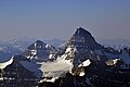
Aerial view of north aspect
Highest point
Elevation 3,305 m (10,843 ft) [1]
Prominence 558 m (1,831 ft) [2]
Parent peak Lunette Peak (3428 m) [2]
Listing Mountains of Alberta
Mountains of British Columbia
Coordinates 50°50′05″N115°37′27″W / 50.83472°N 115.62417°W / 50.83472; -115.62417 [3]
Geography
Canada Alberta relief location map - transverse mercator proj.svg
Red triangle with thick white border.svg
Eon Mountain
Location in Alberta
Canada British Columbia relief location map.jpg
Red triangle with thick white border.svg
Eon Mountain
Location in British Columbia
Canada relief map 2.svg
Red triangle with thick white border.svg
Eon Mountain
Location in Canada
Eon Mountain
Interactive map of Eon Mountain
Country Canada
Provinces Alberta and British Columbia
Parent range Park Ranges [2]
Topo map NTS 82J13 Mount Assiniboine [3]
Climbing
First ascent 1921 Winthrop E. Stone

Eon Mountain is located on the border of Alberta and British Columbia on the Continental Divide. It is Alberta's 41st-highest peak, and the 53rd-highest peak in British Columbia. It was named in 1901 by James Outram. [1] [2]

Contents

The first ascent of Eon was made on July 17, 1921, by Winthrop E. Stone, then President of Purdue University, who fell to his death shortly after reaching the summit. [1] [4] Stone had climbed the final chimney and then unroped on the summit. Upon returning to the chimney he stepped on a loose stone near the edge and fell. His wife was stationed at the base of the final chimney at the time. She was able to descend to 7,500 ft (2,290 m) on the south face and was rescued on July 24. On August 5, a five-man recovery team ascended the SE arête to retrieve Stone's body which was located some 850 ft (260 m) below the summit. [4]

Geology

The mountain is composed of sedimentary rock laid down during the Precambrian to Jurassic periods. [5] Formed in shallow seas, this sedimentary rock was pushed east and over the top of younger rock during the Laramide orogeny. [6]

Climate

Based on the Köppen climate classification, Eon Mountain is located in a subarctic climate zone with cold, snowy winters, and mild summers. [7] Temperatures can drop below −20 °C with wind chill factors below −30 °C.

See also

Related Research Articles

<span class="mw-page-title-main">Ptarmigan Peak (Alberta)</span> Mountain in Alberta, Canada

Ptarmigan Peak is a mountain located near Pika Peak in Banff National Park, Alberta, Canada.

<span class="mw-page-title-main">Mount Hector (Alberta)</span> Mountain in Banff National Park, Alberta, Canada

Mount Hector is a 3,394-metre (11,135-foot) mountain summit located in the Bow River valley of Banff National Park, in the Canadian Rockies of Alberta, Canada. The mountain was named in 1884 by George M. Dawson after James Hector, a geologist on the Palliser expedition. The mountain is located beside the Icefields Parkway, 17 km (11 mi) north of Lake Louise.

<span class="mw-page-title-main">Trapper Peak (Canada)</span> Mountain in Alberta and British Columbia, Canada

Trapper Peak is a mountain in Alberta and British Columbia, Canada, located on their border along the Continental Divide in the Wapta Icefield.

<span class="mw-page-title-main">Saint Nicholas Peak (Canada)</span> Mountain in Canada

Saint Nicholas Peak is a 2,938-metre (9,639-foot) mountain summit in the Rocky Mountains of Canada. It is located on the Continental Divide, on the Alberta-British Columbia border, in both Banff National Park and Yoho National Park. It lies at the eastern edge of the Wapta Icefield, and is part of the Waputik Mountains which are a sub-range of the Canadian Rockies.

<span class="mw-page-title-main">Mount Lyell (Canada)</span> Mountain in Alberta and British Columbia, Canada

Mount Lyell is a mountain on the Alberta–British Columbia border in western Canada. Comprising five distinct summits, Mount Lyell reaches a height of 3,498 m (11,476 ft). The mountain was named by James Hector in 1858 in recognition of Scottish geologist Sir Charles Lyell.

<span class="mw-page-title-main">Mount Allen (Canada)</span> Mountain in Canada

Mount Allen is a mountain in the Canadian Rockies, on the Continental Divide, which forms the provincial boundary between British Columbia and Alberta in this region. J. Monroe Thorington named this mountain for Samuel Evans Stokes Allen in 1924. Allen was an American cartographer who mapped this area of the Rockies in 1894–1895. Allen had named this mountain "Shappee", the Stoney language word for "six", as part of his naming of the ten mountains in the Valley of the Ten Peaks. The peak forms part of the backdrop to Moraine Lake in Banff National Park.

<span class="mw-page-title-main">Mount Balfour</span> Mountain in Canadian Rockies

Mount Balfour is a mountain located on the Continental Divide, part of the border between British Columbia and Alberta, in the Waputik Range in the Park Ranges of the Canadian Rockies. It is the 71st highest peak in Alberta and the 113th highest in British Columbia; it is also the 52nd most prominent in Alberta.

<span class="mw-page-title-main">Mount Robertson</span> Mountain in the country of Canada

Mount Robertson is a mountain in the Canadian Rockies, standing astride the British Columbia-Alberta boundary between Palliser Pass and North Kananaskis Pass. The British Columbia side of the pass is in Mount Assiniboine Provincial Park. The mountain is named for Sir William Robertson (1860–1933), 1st Baronet, Chief of the Imperial General Staff from 1916 to 1918 during the First World War.

<span class="mw-page-title-main">Stairway Peak</span> Mountain in Alberta and British Columbia, Canada

Stairway Peak is a 3,006 metres (9,862 ft) mountain summit located on the Continental Divide, on the shared border of Alberta and British Columbia in the Canadian Rockies. It is also on the shared border between Banff National Park and Yoho National Park, and can be seen from the Icefields Parkway. It was named in 1918 by Arthur O. Wheeler.

<span class="mw-page-title-main">Wonder Peak</span> Mountain in the country of Canada

Wonder Peak is located on the border of Alberta and British Columbia in the Canadian Rockies. Situated on the Continental Divide, it also straddles the shared boundary of Banff National Park with Mount Assiniboine Provincial Park. It was named in 1913 by Arthur O. Wheeler and Conrad Kain.

<span class="mw-page-title-main">The Towers (Canada)</span> Mountain in the country of Canada

The Towers is a 2,842-metre (9,324-foot) mountain located on the border of Alberta and British Columbia on the Continental Divide. It also straddles the shared boundary of Banff National Park with Mount Assiniboine Provincial Park. It was named in 1917 by Arthur O. Wheeler. Its nearest higher peak is Mount Magog, 2.5 km (1.6 mi) to the west.

<span class="mw-page-title-main">Mount Magog</span> Mountain in Alberta/British Columbia, Canada

Mount Magog is located on the border of Alberta and British Columbia on the Continental Divide in the Canadian Rockies. It also straddles the shared boundary of Banff National Park with Mount Assiniboine Provincial Park. It was named in 1930 after references in the Bible.

<span class="mw-page-title-main">Aye Mountain</span> Mountain in the country of Canada

Aye Mountain is located on the Canadian provincial boundary between Alberta and British Columbia on the Continental Divide. It was named in 1913 by the Interprovincial Boundary Survey.

<span class="mw-page-title-main">Forum Peak</span> Mountain in the country of Canada

Forum Peak is a summit located on the border of Alberta and British Columbia on the Continental Divide. It is the southernmost mountain in the Canadian Rockies, situated only 500 metres north of the Canada–United States border. It was named after Forum Lake below the mountain. It is visible from the end of Highway 5 at Cameron Lake, which is within Waterton Lakes National Park, and the mountain is on the park's southwest border.

<span class="mw-page-title-main">Wedgwood Peak</span> Mountain in the country of Canada

Wedgwood Peak is a 3,024-metre (9,921-foot) mountain summit located in Mount Assiniboine Provincial Park, in the Canadian Rockies of British Columbia, Canada. Its nearest higher peak is Mount Assiniboine, 2.0 km (1.2 mi) to the south. The mountain is situated northwest of Lake Magog and 1.0 km (0.62 mi) south of Sunburst Peaks.

<span class="mw-page-title-main">The Marshall</span> Mountain in the country of Canada

The Marshall is a 3,180-metre (10,430-foot) mountain summit located in Mount Assiniboine Provincial Park, in the Canadian Rockies of British Columbia, Canada. Its nearest higher peak is Mount Assiniboine, 3.0 km (1.9 mi) to the east-southeast. The mountain is situated west of Wedgwood Peak.

<span class="mw-page-title-main">Sunburst Peaks</span> Group of mountains in British Columbia, Canada

Sunburst Peaks is a 2,849-metre (9,347-foot) mountain summit located in Mount Assiniboine Provincial Park, in the Canadian Rockies of British Columbia, Canada. Its nearest higher peak is Wedgwood Peak, 1.0 km (0.62 mi) to the south. The mountain is situated immediately southeast of Sunburst Lake, west of Lake Magog, and south of Cerulean Lake.

<span class="mw-page-title-main">Mount Watson (Canadian Rockies)</span> Mountain in the country of Canada

Mount Watson is a 2,955-metre (9,695-foot) mountain summit located in Mount Assiniboine Provincial Park, in the Canadian Rockies of British Columbia, Canada. The nearest higher peak is The Marshall, 2.0 km (1.2 mi) to the southeast.

<span class="mw-page-title-main">Naiset Point</span> Mountain in the country of Canada

Naiset Point is a 2,755-metre (9,039-foot) mountain summit located in Mount Assiniboine Provincial Park, in the Canadian Rockies of British Columbia, Canada. The mountain is situated 1.0 km (0.62 mi) southeast of Lake Magog, and at the end of the ridge extending north from Terrapin Mountain. Naiset Point is composed of sedimentary rock laid down during the Cambrian period. Formed in shallow seas, this sedimentary rock was pushed east and over the top of younger rock during the Laramide orogeny.

<span class="mw-page-title-main">Nub Peak</span> Mountain in the country of Canada

Nub Peak is a 2,746-metre (9,009-foot) mountain summit located in Mount Assiniboine Provincial Park, in the Canadian Rockies of British Columbia, Canada. Its nearest higher peak is Nestor Peak, 4.0 km (2.5 mi) to the west. The mountain is situated north of Sunburst Peaks, with Elizabeth Lake and Cerulean Lake in between. The Continental Divide and Assiniboine Pass are situated 3.5 km (2.2 mi) to the east. Nub Peak is famous for its panoramic view of Mount Assiniboine with its surrounding lakes and peaks. The mountain's descriptive name was officially adopted in 1924. An arm extending southwest from Nub is officially known as Chucks Ridge, and an arm extending southeast is officially called Nublet. Nub Peak is composed of sedimentary rock laid down during the Cambrian period and pushed east over the top of younger rock during the Laramide orogeny.

References

  1. 1 2 3 "Eon Mountain". cdnrockiesdatabases.ca. Retrieved 2019-08-11.
  2. 1 2 3 4 "Eon Mountain". Bivouac.com. Retrieved 2019-08-27.
  3. 1 2 "Eon Mountain". Geographical Names Data Base . Natural Resources Canada . Retrieved 2019-08-27.
  4. 1 2 Thorington, J. Monroe (1966) [1921]. "White Man Pass to Simpson Pass". A Climber's Guide to the Rocky Mountains of Canada. With the collaboration of Putnam, William Lowell (6th ed.). American Alpine Club. p. 42. ISBN   978-1376169003.
  5. Belyea, Helen (1960). "The Story of the Mountains in Banff National Park" (PDF). Geological Survey of Canada. Archived (PDF) from the original on 2 October 2015. Retrieved 2019-06-23.
  6. Gadd, Ben (2008). "Geology of the Rocky Mountains and Columbias".{{cite journal}}: Cite journal requires |journal= (help)
  7. Peel, M. C.; Finlayson, B. L.; McMahon, T. A. (2007). "Updated world map of the Köppen−Geiger climate classification". Hydrol. Earth Syst. Sci. 11 (5): 1633–1644. Bibcode:2007HESS...11.1633P. doi: 10.5194/hess-11-1633-2007 . ISSN   1027-5606. S2CID   9654551.