Gangapur, Varanasi

Last updated

Gangapur
Town
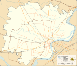
Varanasi district location map.svg
Red pog.svg
Gangapur
Location in Uttar Pradesh, India
Coordinates: 25°27′35″N82°52′42″E / 25.459835°N 82.878195°E / 25.459835; 82.878195
CountryFlag of India.svg  India
State Uttar Pradesh
District Varanasi
Elevation
448 m (1,470 ft)
Population
 (2001)
  Total6,388
Languages
  Official Hindi
Time zone UTC+5:30 (IST)
Vehicle registration UP
Website up.gov.in

Gangapur is a town and a nagar panchayat in Varanasi district in the state of Uttar Pradesh, India.
Demographics

As of the 2001 Census of India, [1] Gangapur had a population of 6,388. Males constitute 53% of the population and females 47%. Gangapur has an average literacy rate of 55%, lower than the national average of 59.5%: male literacy is 63%, and female literacy is 46%. In Gangapur, 20% of the population is under 6 years of age.

Related Research Articles

<span class="mw-page-title-main">Puthunagaram</span> Town in Kerala, India

Puthunagaram is a town and gram panchayat in the Palakkad district, state of Kerala, India. It is about 10 km south of Palakkad and 8 Km from Kollengode. Palakkad-Pollachi railway line passes through this town.

<span class="mw-page-title-main">Habra</span> City in West Bengal, India

Habra is a city and a municipality under Barasat sadar subdivision in North 24 Parganas district of the Indian state of West Bengal. It is situated on the Jessore Road between Kolkata and the Bangladesh border at Petrapole. Its location makes it an important town for export and import of goods between India and Bangladesh.

<span class="mw-page-title-main">Birwadi</span> Census town in Maharashtra, India

Birwadi is a census town in Raigad district in the state of Maharashtra, India.

Chinnasekkadu is a neighbourhood of Chennai in Chennai district in the state of Tamil Nadu, India. Chinnasekkadu used to be a town panchayat in Thiruvallur district. In 2011, Chinnasekkadu town panchayat was merged with Chennai Corporation. Chinnasekkadu comes under ward 29 in Zone 3(Madhavaram) of Chennai Corporation.

Dhanuha is a census town in Jaunpur district in the state of Uttar Pradesh, India.

Ezhudesam is a town panchayat in Kanniyakumari district in the state of Tamil Nadu, India.

Gangapur is a town and a municipal council in Aurangabad district in the state of Maharashtra, India.

Gangapur is a city and a municipality in Bhilwara district in the state of Rajasthan, India.

Herohalli is a census town in Bangalore district in the Indian state of Karnataka.

Mahu Kalan is a census town in Gangapur City district in the Indian state of Rajasthan.

Naravarikuppam is a town in Thiruvallur district in the Indian state of Tamil Nadu.

Duttapukur is a census town and a gram panchayat in the Barasat I CD block in the Barasat Sadar subdivision in the North 24 Parganas district in the Indian state of West Bengal. It is a part of Kolkata Urban Agglomeration.

Sadpur is a census town in the Habra I CD block in the Barasat Sadar subdivision in the North 24 Parganas district in the Indian state of West Bengal.

Thevaram is a town in Theni district in the Indian state of Tamil Nadu. Thevaram is located in Tamil Nadu near the border of Kerala at the Eastern side foot-hill of the Western Ghats. It is connected with State Highway SH100.

Todabhim is a city and a "municipality" in Gangapur City district in the Indian state of Rajasthan. It is headquarters of Todabhim sub division, tehsil and C&RD block of Gangapur City district.

Vengathur is a census town in Thiruvallur district in the Indian state of Tamil Nadu.

Jafarabad is a town and nagar panchayat in Jaunpur district in the Indian state of Uttar Pradesh.

Kerur is a town in Bagalkot district in Karnataka, which located on NH 218. It has an average elevation of 617 meters (2024 feet). It's the birthplace of Jagadish Shettar, a former Chief Minister of Karnataka. Kerur is a Town Panchayat city in the district of Bagalkot, Karnataka. The Kerur city is divided into 16 wards for which elections are held every five years. The Kerur Town Panchayat has a population of 19,731 of which 9,929 are males while 9,802 are females as per report released by Census India 2011.

Gangapur is a census town in the Barasat I CD block in the Barasat Sadar subdivision in the North 24 Parganas district in the Indian state of West Bengal. It is a part of Kolkata Urban Agglomeration.

Koshithal is a Gram Panchayat and Village Located in Sahara tehsil, nearby Gangapur town in Bhilwara District of Ajmer division in the Indian State of Rajasthan. It is located in Raipur Vidhan Sabha which governed by MLA Gayatri Kailash Trivedi Of Indian National Congress. Koshithal is largest and one of the most important Gram Panchayat in Bhilwara District. As of 2011, the population of Koshithal is 7153 having almost 1447 households. It is located 300 kms southwest of the state capital Jaipur and 60 kms away from District Headquarter Bhilwara. The village have historically rich history contemporary with Maharana Pratap. It is known for Koshithal Fort and for public cemetery where many War Martyr cremated. It is belief that Koshithal has large number of War Martyr Cremated in Local Cemetery after Chittaurgarh in Rajasthan.

References

  1. "Census of India 2001: Data from the 2001 Census, including cities, villages and towns (Provisional)". Census Commission of India. Archived from the original on 16 June 2004. Retrieved 1 November 2008.