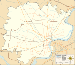
Kotwa

Last updated

Kotwa
city
Varanasi district location map.svg
Red pog.svg
Kotwa
Location in Varanasi district
Coordinates: 25°20′11″N83°03′18″E / 25.336427°N 83.054931°E / 25.336427; 83.054931 Coordinates: 25°20′11″N83°03′18″E / 25.336427°N 83.054931°E / 25.336427; 83.054931
CountryFlag of India.svg  India
State Uttar Pradesh
District Varanasi
Government
  Type Municipal corporation
Population
 (2001)
  Total12,411
Languages
  Official Hindi
Time zone UTC+5:30 (IST)
Vehicle registration UP
Website up.gov.in

Kotwa is a census town in Varanasi district in the Indian state of Uttar Pradesh.

Demographics

Religion in Kotwa (2011)
ReligionPercent
Islam
80.76%
Hinduism
18.29%
Christianity
0.88%
Sikhism
0.01%
Buddhism
0.01%
Others
0.06%

As of 2001 India census, [1] Kotwa had a population of 12,411. Males constitute 53% of the population and females 47%. Kotwa has an average literacy rate of 39%, lower than the national average of 59.5%: male literacy is 47%, and female literacy is 30%. In Kotwa, 23% of the population is under 6 years of age.

Related Research Articles

Bhogpur city in Punjab, India

Bhogpur is a town and a nagar panchayat in Jalandhar district in the state of Punjab, India. Bhogpur is the first city from the overall india who created its own website on city name. Bhogpur sugar mill is first Co-operative sugar mill and still running successfully.

Bhulath city in Punjab, India

Bholath is a town and a nagar panchayat in Kapurthala district in the state of Punjab, India. Bholath was town of raja Bharat.

Bilpura, Madhya Pradesh city in Madhya Pradesh, India

Khamaria is a census town in Jabalpur district in the state of Madhya Pradesh, India.

Dhampur city in Uttar Pradesh, India

Dhampur is a city and a municipal board in Bijnor district in the state of Uttar Pradesh, India. It is located at 29.51°N 78.50°E, and lies in Northern India.

Dhanauha city in Uttar Pradesh, India

Dhanuha is a census town in Jaunpur district in the state of Uttar Pradesh, India.

Dighawani city in Madhya Pradesh, India

Dighawani is a census town in Chhindwara district in the state of Madhya Pradesh, India.

Herohalli city in Karnataka, India

Herohalli is a census town in Bangalore district in the Indian state of Karnataka.

Kaliyikkavila Town in Tamil Nadu, India

Kaliakkavila is a panchayat town in Kanyakumari district in the Indian state of Tamil Nadu, close to the Tamil Nadu-Kerala border. It lies on the Kochi-Thiruvananthapuram-Kanyakumari National highway 47.

Kherdi city in Maharashtra, India

Kherdi is a census town in Ratnagiri in the Indian state of Maharashtra. It has Maharashtra Industrial Development Corporation (MIDC).

Kiraoli City in Uttar Pradesh, India

Kiraoli is a town and a nagar panchayat in Agra district in the Indian state of Uttar Pradesh.

Kothnur city in Karnataka, India

Kothnur is a census town in Bangalore district in the Indian state of Karnataka.

Newa Talai city in Rajasthan, India

Newa Talai is a census town in Udaipur district in the Indian state of Rajasthan.

Suhagi city in Madhya Pradesh, India

Suhagi is a census town in Jabalpur district in the Indian state of Madhya Pradesh.

Talegaon Dabhade Town in Maharashtra, India

Talegaon Dabhade is a town in Mawal Taluka, Pune district, in the Indian state of Maharashtra. It is 120 km (75 mi) from Mumbai and 35 km (22 mi) from Pune.

Papparapatti, Salem city in Tamil Nadu, India

Papparapatti is a census town in Salem district in the Indian state of Tamil Nadu.

Rajnagar, Chhatarpur city in Madhya Pradesh, India

Rajnagar is a town and Nagar Panchayat in Chhatarpur district in the Indian state of Madhya Pradesh,6 km from Khajuraho,5 km from khajwa town/village and 35.1 km from district headquarters Chhatarpur.

Kari, Tikamgarh city in Madhya Pradesh, India

Kari is a town and a nagar panchayat in Tikamgarh district in the Indian state of Madhya Pradesh.

Gangapur, Varanasi city in Uttar Pradesh, India

Gangapur is a town and a nagar panchayat in Varanasi district in the state of Uttar Pradesh, India.

Fatehabad, Haryana Town in Haryana, India

Fatehabad is a town and a municipal committee in Fatehabad district in the state of Haryana, India.

Kangan, Jammu and Kashmir Town in Jammu and Kashmir, India

Kangan is a town in Ganderbal district, of Jammu and Kashmir, India. It is one of the tehsils in Ganderbal District. It is situated across the Nallah Sindh and spread over a 50-km-long gorge valley, with population of 1,20,934 and literacy rate of 52.8% and sex ratio 868 per thousand males. It is one of the beautiful places surrounded by various picnic spots like Sonamarg and Naranag. It is believed that the place embraces its name with the fact that it is surrounded by mountains in all sides, gives it a ring shape, which is called in Hindi kangan.

References

  1. "Census of India 2001: Data from the 2001 Census, including cities, villages and towns (Provisional)". Census Commission of India. Archived from the original on 16 June 2004. Retrieved 1 November 2008.