"},"population_as_of":{"wt":"2020"},"population_total":{"wt":"2718"},"pop_est_footnotes":{"wt":""},"pop_est_as_of":{"wt":""},"population_est":{"wt":""},"population_density_sq_mi":{"wt":"2.5"},"district":{"wt":"1st"},"time zone":{"wt":"Central"},"website":{"wt":"{{URL|https://govecountyks.org/|govecountyks.org}}"}},"i":0}}]}" id="mwCQ">County in Kansas
Gove County | |
---|---|
![]() | |
![]() Location within the U.S. state of Kansas | |
![]() Kansas's location within the U.S. | |
Coordinates: 38°55′12″N100°29′48″W / 38.92°N 100.4967°W | |
Country | ![]() |
State | ![]() |
Founded | March 11, 1868 |
Named for | Grenville L. Gove |
Seat | Gove City |
Largest city | Quinter |
Area | |
• Total | 1,072 sq mi (2,780 km2) |
• Land | 1,072 sq mi (2,780 km2) |
• Water | 0.1 sq mi (0.3 km2) 0.01% |
Population | |
• Total | 2,718 |
• Density | 2.5/sq mi (1.0/km2) |
Time zone | UTC−6 (Central) |
• Summer (DST) | UTC−5 (CDT) |
Congressional district | 1st |
Website | govecountyks.org |
Gove County is a county in the U.S. state of Kansas. Its county seat is Gove City, [2] and its most populous city is Quinter. As of the 2020 census, the county population was 2,718. [1] The county was named for Granville Gove, a captain of Company G of the 11th Kansas Cavalry Regiment Volunteer Cavalry, who died from battle wounds during the American Civil War.
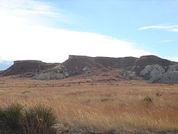
Eighty million years ago, Gove County was part of an ancient inland sea known as the Western Interior Seaway. Many students still visit the Castle Rock Badlands today to explore fossils. [3]
For many millennia, the Great Plains of North America were inhabited by nomadic Native Americans. From the 16th to the 18th centuries, the Kingdom of France claimed ownership of large parts of North America. In 1762, after the French and Indian War, France secretly ceded New France to Spain, per the Treaty of Fontainebleau.
In 1802, Spain returned most of the land to France, but kept the title to about 7,500 square miles. In 1803, most of the land for modern-day Kansas was acquired by the United States from France as part of the 828,000-square-mile Louisiana Purchase for 2.83 cents per acre.
In 1854, the Kansas Territory was organized; then in 1861, Kansas became the 34th U.S. state. In 1868, Gove County was established and named for Granville Llewellyn Gove, member of the 11th Regiment Kansas Volunteer Cavalry, and son of Moses Gove, a former mayor of Manhattan, Kansas. [4] [5]
In 2020, USA Today profiled Gove County during the COVID-19 pandemic in the United States, and called it the "deadliest place in America" due to it having the highest death rate from COVID-19 compared to any other county in the nation: One out of every 132 people. The first deaths were reported on October 7; as of November 2020, 20 residents died from the virus, and 314 other positive cases were reported. The article attributed the high death rate to predominant public opposition towards wearing face masks, doubts over the pandemic's severity, and the county's high median age, all of which left residents highly vulnerable. [6]
According to the U.S. Census Bureau, the county has an area of 1,072 square miles (2,780 km2), of which 0.1 square miles (0.26 km2) (0.01%) is covered by water. [7]
Census | Pop. | Note | %± |
---|---|---|---|
1880 | 1,196 | — | |
1890 | 2,994 | 150.3% | |
1900 | 2,441 | −18.5% | |
1910 | 6,044 | 147.6% | |
1920 | 4,748 | −21.4% | |
1930 | 5,643 | 18.9% | |
1940 | 4,793 | −15.1% | |
1950 | 4,447 | −7.2% | |
1960 | 4,107 | −7.6% | |
1970 | 3,940 | −4.1% | |
1980 | 3,726 | −5.4% | |
1990 | 3,231 | −13.3% | |
2000 | 3,068 | −5.0% | |
2010 | 2,695 | −12.2% | |
2020 | 2,718 | 0.9% | |
2023 (est.) | 2,735 | [8] | 0.6% |
U.S. Decennial Census [9] 1790-1960 [10] 1900-1990 [11] 1990-2000 [12] 2010-2020 [1] |
As of the 2000 census, [13] 3,068 people, 1,245 households, and 861 families resided in the county. The population density was 3 people per square mile (1.2 people/km2). The 1,423 housing units had an average density of 1 per square mile (0.39/km2). The racial makeup of the county was 97.95% White, 0.10% Black or African American, 0.16% Native American, 0.10% Asian, 0.72% from other races, and 0.98% from two or more races. Hispanics or Latinos of any race were 1.24% of the population.
Of the 1,245 households, 28.4% had children under 18 living with them, 63.5% were married couples living together, 3.5% had a female householder with no husband present, and 30.8% were not families. About 29.7% of all households were made up of individuals, and 17.5% had someone living alone who was 65 or older. The average household size was 2.42 and the average family size was 3.01.
In the county, the age distribution was 26.2% under 18, 5.4% from 18 to 24, 22.1% from 25 to 44, 23.7% from 45 to 64, and 22.7% who were 65 or older. The median age was 43 years. For every 100 females, there were 95.20 males. For every 100 females 18 and over, there were 92.30 males.
The median income for a household in the county was $33,510, and for a family was $40,438. Males had a median income of $26,863 versus $21,357 for females. The per capita income for the county was $17,852. About 8.0% of families and 10.30% of the population were below the poverty line, including 13.9% of those under 18 and 6.9% of those 65 or over.
In 2020, Gove County had 2,600 residents, and the median age was about 50, a decade older than the national average. [6]
Year | Republican | Democratic | Third party(ies) | |||
---|---|---|---|---|---|---|
No. | % | No. | % | No. | % | |
2024 | 1,227 | 87.77% | 150 | 10.73% | 21 | 1.50% |
2020 | 1,291 | 87.76% | 166 | 11.28% | 14 | 0.95% |
2016 | 1,140 | 84.88% | 149 | 11.09% | 54 | 4.02% |
2012 | 1,168 | 84.45% | 176 | 12.73% | 39 | 2.82% |
2008 | 1,136 | 80.11% | 261 | 18.41% | 21 | 1.48% |
2004 | 1,196 | 81.53% | 247 | 16.84% | 24 | 1.64% |
2000 | 1,122 | 75.05% | 296 | 19.80% | 77 | 5.15% |
1996 | 1,123 | 69.19% | 351 | 21.63% | 149 | 9.18% |
1992 | 792 | 46.42% | 379 | 22.22% | 535 | 31.36% |
1988 | 966 | 57.36% | 663 | 39.37% | 55 | 3.27% |
1984 | 1,310 | 73.43% | 426 | 23.88% | 48 | 2.69% |
1980 | 1,263 | 71.11% | 396 | 22.30% | 117 | 6.59% |
1976 | 860 | 48.95% | 848 | 48.26% | 49 | 2.79% |
1972 | 1,226 | 69.86% | 466 | 26.55% | 63 | 3.59% |
1968 | 1,018 | 59.05% | 538 | 31.21% | 168 | 9.74% |
1964 | 774 | 42.69% | 1,022 | 56.37% | 17 | 0.94% |
1960 | 1,065 | 55.85% | 828 | 43.42% | 14 | 0.73% |
1956 | 1,315 | 72.29% | 492 | 27.05% | 12 | 0.66% |
1952 | 1,453 | 75.84% | 453 | 23.64% | 10 | 0.52% |
1948 | 1,030 | 57.48% | 719 | 40.12% | 43 | 2.40% |
1944 | 1,125 | 72.02% | 420 | 26.89% | 17 | 1.09% |
1940 | 1,352 | 66.31% | 659 | 32.32% | 28 | 1.37% |
1936 | 1,107 | 49.75% | 1,090 | 48.99% | 28 | 1.26% |
1932 | 1,043 | 45.75% | 1,186 | 52.02% | 51 | 2.24% |
1928 | 1,470 | 70.95% | 590 | 28.47% | 12 | 0.58% |
1924 | 1,211 | 67.77% | 400 | 22.38% | 176 | 9.85% |
1920 | 950 | 74.92% | 285 | 22.48% | 33 | 2.60% |
1916 | 642 | 40.07% | 862 | 53.81% | 98 | 6.12% |
1912 | 170 | 18.56% | 355 | 38.76% | 391 | 42.69% |
1908 | 632 | 55.15% | 456 | 39.79% | 58 | 5.06% |
1904 | 470 | 63.17% | 204 | 27.42% | 70 | 9.41% |
1900 | 368 | 58.41% | 253 | 40.16% | 9 | 1.43% |
1896 | 279 | 55.36% | 204 | 40.48% | 21 | 4.17% |
1892 | 327 | 56.87% | 0 | 0.00% | 248 | 43.13% |
1888 | 586 | 65.84% | 278 | 31.24% | 26 | 2.92% |
Although the Kansas Constitution was amended in 1986 to allow the sale of alcoholic liquor by the individual drink with the approval of voters, Gove County has remained a prohibition, or "dry", county. [15]
List of townships / incorporated cities / unincorporated communities / extinct former communities within Gove County. [16]
‡ means a community has portions in an adjacent county.
Gove County is divided into nine townships. None of the cities within the county are considered governmentally independent, and all figures for the townships include those of the cities. In the following table, the population center is the largest city (or cities) included in that township's population total, if it is of a significant size.