Hurricane Norbert (2008)

Last updated
Map key
  Tropical depression (≤38 mph, ≤62 km/h)
  Tropical storm (39–73 mph, 63–118 km/h)
  Category 1 (74–95 mph, 119–153 km/h)
  Category 2 (96–110 mph, 154–177 km/h)
  Category 3 (111–129 mph, 178–208 km/h)
  Category 4 (130–156 mph, 209–251 km/h)
  Category 5 (≥157 mph, ≥252 km/h)
  Unknown
Storm type
Disc Plain black.svg Tropical cyclone
Solid black.svg Subtropical cyclone
ArrowUp.svg Extratropical cyclone, remnant low, tropical disturbance, or monsoon depression

The origins of Norbert were from a tropical wave that crossed Central America on September 26 and September 27. An area of disturbed weather formed near the Gulf of Tehuantepec on September 28, [1] which at that time was mentioned on the Tropical Weather Outlook (an outlook issued every six hours during hurricane season by the NHC that notes the possibility of tropical cyclogenesis during the next 48 hours). [1] Drifting westward off the coast of Mexico, the system initially consisted of a broad low pressure area and an area of disorganized convection. [2] It slowly organized for several days, and by early on October 4 the system developed enough organized convection to be classified as Tropical Depression Fifteen; at that point, it was located about 230 miles (370 km) south of Acapulco. The depression was located over an area of warm water temperatures and moderate vertical wind shear, and as such was forecast to intensify gradually. [3]

Tropical Depression Fifteen-E on October 4 TD Fifteen-E 2008 Oct 4 1445Z.jpg
Tropical Depression Fifteen-E on October 4

About six hours after forming, the circulation of the depression became exposed from the deep convection, due to the wind shear. At the same time, two tropical cyclone forecast models predicted the tropical cyclone formation of a larger disturbance to the southeast of the depression. [4] One model predicted the new cyclone to absorb the depression, although most other models forecast for the depression to remain the dominant system. [5] By early on October 5, deep convection developed and organized around the center of the depression, and satellite intensity estimates using the Dvorak technique suggested that the system had tropical storm force-winds; as a result, the NHC upgraded the depression to Tropical Storm Norbert, about 245 mi (395 km) south of Zihuatanejo. [6] Norbert slowly intensified, [1] and was upgraded to a hurricane on October 6 as very deep atmospheric convection remained stable despite easterly wind shear. [7]

On October 7, Hurricane Norbert reached Category 2 intensity on the Saffir-Simpson Hurricane Scale while Norbert developed well-defined and closed eyewall as seen in microwave imagery. [8] Overnight on October 8, an eye appeared on infrared satellite, indicating that Norbert was intensifying and the storm was upgraded to a major hurricane respectively. [9] Continuing to rapidly strengthen over warm sea surface temperatures, it reached Category 4 status late on October 8, after intensifying 45 mph (72 km/h) over the previous 24 hours. The storm peak intensity was 135 mph (217 km/h) and a peak pressure of 945 mbar (hPa; 27.91 inHg) while located 350 mi (560 km) south of Cabo San Lucas, Baja California Sur. The peak intensity of Norbert is uncertain as aircraft-based wind speed observations were lower than estimates via Dvorak Technique. [1] However, the cloud pattern became less impressive early on October 9, and was thus downgraded into a Category 3 hurricane, with winds of 125 mph (201 km/h) as it moved. [10] The eye began to erode and as such Norbert underwent an eyewall replacement cycle, where one eye is replaced by another. As a result, when Hurricane Hunters investigated the storm later that day, they found that Norbert had weakened considerably. At that time, it was downgraded into a weak Category 1 hurricane on October 9. [1]

On October 10, Norbert turned towards the north while slowing down as it reached the western edge of a subtropical ridge. In an area of light wind shear, Norbert began to re-intensify as the eyewall replacement cycle completed. The cyclone turned to the north-northeast due to a mid to upper-level trough that was moving over the Southwest United States. Norbert managed to restrengthen into a Category 3 hurricane on 0600 UTC October 11, and made landfall as a Category 2 hurricane near Puerto Chale. [1] The next day, Norbert struck southern Sonora at Category 1 intensity. [1] Norbert rapidly dissipated by October 12 while inland over Mexico. [1] Norbert was a Category 2 hurricane at landfall [11] and is currently tied with Hurricane Jimena for the strongest storm to strike the west coast of the Baja California Peninsula. [12]

Preparations

Norbert as a Category 3 hurricane HR Norbert 2008 Oct 7 1400Z.jpg
Norbert as a Category 3 hurricane

A hurricane warning was issued on October 10 for parts of the central Baja California Peninsula from Puerto San Andresito southward to Agua Blanca, and they extended around the peninsula from La Paz to Loreto. The warnings were put in place on the mainland west coast from Topolobampo to Guaymas. Hurricane watches were issued from Agua Blanca to Cabo San Lucas, and were extended around the Baja California peninsula to La Paz; these same areas were also under tropical storm warnings as well. Tropical storm warnings also extended from Loreto northward to Mulegé on the eastern side of the peninsula. [1]

On October 10, officials in Baja California declared the municipalities of Loreto, Comondú and La Paz disaster areas in anticipation of severe damage from the hurricane. [13] The mayor of Los Cabos, Óscar Núñez, strongly advised residents living in sub-par housing and in low-lying areas to prepare to evacuate. The local civil protection official stated bridges are ready to begin evacuating. [14] As the storm produced cloudy skies in Baja California, fishermen moved their boats onto the beach in La Paz. Beach officials warned people to stay out of the water. As flood water rose, residents fled from their homes and into shelters. [15] "All precautions are in place ... we have prepared temporary shelters," said Jose Gajón, director of Baja California Sur rescue services. The NHC warned interests in the area to monitor the progress of Norbert. The storm was expected by the NHC to reach the U.S. States of New Mexico, Texas, and Arizona as a tropical depression. [16] In Ciudad Obregón, Sonora, farmers rushed to fertilize the fields prior to the passage of Norbert. [14]

Impact

Hurricane Norbert at its landfall on Baja California Sur on October 11 Norbert 11 oct 2008 1820Z.jpg
Hurricane Norbert at its landfall on Baja California Sur on October 11

Baja California Sur

The storm was responsible for 13 ft (4.0 m) waves. [17] Norbert was also responsible produced peak winds of 60 mph (97 km/h) and a 70 mph (110 km/h) gust in Los Mochis. This observation occurred at 0200 UTC October 12. The maximum single-day rainfall total from Norbert was 4.78 in (121 mm) in Ciudad Constitucion. [1]

Throughout Baja California Sur, officials estimated that damages from the hurricane was equivalent to 292.2 million MXN (25 million USD). [18] Water damages totaled to 8.8 million MXN (US$650,000). Furthermore, damage to homes was 68.3 million pesos (US$6 million) while damage to school was reported to be 5 million MXN (US$41,000). In addition, highway damage totaled to 36.6 million MXN (USD). [13] Roughly 5,000 homes sustained severe damage and roads throughout the state were also severely affected. [17] About 100,000 people were without power at the height of the storm. [13] The worst damage occurred in the municipality of Comondú where 16,000 residents reported damage to their homes. [17] A total of 2,850 people were housed in temporary shelters. According to tourism officials, hotel reservations were down 40% in Los Cabos and Lorento Roofs were ripped off buildings and many trees were damaged. On the islands of Santa Margarita and Magdalena, 40% of homes received some damage, mostly roof damage. La Paz International Airport closed prior to the arrival of the system, but Los Cabos International Airport remained open throughout the passage of the tropical cyclone. [19] In La Paz, the storm produced violent winds, a few last-minute drivers on streets with fallen trees. Rescue workers had to rescue many residents of low-lying areas from their wood and sheet metal homes. In a drive-thru entrance, a happy hour sign was ripped off due to strong winds. [20] Local residents south shelter by school buses and army trucks as floodwaters entered their homes. High winds uprooted palm trees and the water was knee-deep in many areas of Puerto San Carlos. [21]

The storm also affected cruise ships. While Carnival Pride and Island Princess survived the worst of the hurricane, the Carnival Elation was expected to arrive one day earlier than initially anticipated. [22]

Sonora

After crossing the Gulf of California, Norbert made landfall in Sonora as a strong Category 1 hurricane. [23] A total of 25 people were killed, [24] five of which were in Álamos. [1] In addition, three others were reported as missing. [25] [26] Total damage in Sonora, excluding the city of Álamos, was estimated at MXN 800 million (2008, $59.1 million). [27] At the port of Topolobampo, rough seas from the storm sank four ships and damaged 70 others. [26] The city of Álamos sustained the most severe damage in the area, with damage exceeding MXN 200 million ($14.7 million). [25] In Álamos, water rushed down the mountains nearby, flooding almost every channel in the city. Some scared residents fled to rooftops and higher ground. A total of 95 homes were destroyed and concrete walls were knocked down. Cars and trucks smashed in trees. Furniture and other personal items were on the streets after the storm. [28]

Sinaloa

The fishing industry in Sinaloa sustained severe losses, with 200 shrimp boats being destroyed leaving MXN 8 million (2008, US$600,000 ) in damages. [29] Roughly 6,000 people were left homeless in Sinaloa as hundreds of homes were damaged or destroyed by Norbert. [26] Officials evacuated 6,000 people in four municipalities (Guasave, Ahome, Choix and El Fuerte). Due to flooding, officials announced that would evacuate seven communities. The port of Mazatlán was closed for navigation. [30] A state of emergency was declared for five municipalities throughout the region. [31]

United States

The remnants of the storm dropped moderate precipitation across western Texas, but there were no immediate issues. [32] Across New Mexico, a deep upper-level low enhanced moisture across the region. [33] A severe thunderstorm moved over Torrance County. Six power poles were snapped, a steel building was destroyed and blown onto Interstate 40 and three water tanks were severely damaged. Winds of 60 to 70 mph (97 to 113 km/h) were recorded with gusts up to 100 mph (160 km/h). Throughout the state, total damage equaled $143,000. [34] [35] [36] [37] [38]

Aftermath

On October 14, Governor Eduardo Bours Castelo of Sonora announced a two-year reconstruction plan for Álamos with an initial budget of MXN 100 million ($7.3 million). The government of Sonora provided at least MXN 400 million ($29.5 million) in relief funds following the hurricane. [27] In Sinaloa, the municipalities of Ahome, El Fuerte, Choix, Guasave and the city of Sinaloa de Leyva were declared disaster areas following the storm, allowing federal funding and supplies to be sent to the regions. [25] Most of northern Sinaloa was also declared a disaster area. [29]

See also

Related Research Articles

<span class="mw-page-title-main">Hurricane Ismael</span> Category 1 Pacific hurricane in 1995

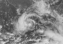
Hurricane Ismael was a weak, but deadly Pacific hurricane that killed over one hundred people in northern Mexico in September of the 1995 Pacific hurricane season. It developed from a persistent area of deep convection on September 12, and steadily strengthened as it moved to the north-northwest. Ismael attained hurricane status on September 14 while located 210 miles (340 km) off the coast of Mexico. It continued to the north, and after passing a short distance east of Baja California Sur it made landfall on Topolobampo in the state of Sinaloa with winds of 80 mph (130 km/h). Ismael rapidly weakened over land, and dissipated on September 16 over northwestern Mexico. The remnants entered the United States and extended eastward into the Mid-Atlantic States.

<span class="mw-page-title-main">Hurricane Juliette (2001)</span> Category 4 Pacific hurricane in 2001

Hurricane Juliette was a powerful Pacific hurricane that struck Mexico in September 2001. A long-lived tropical cyclone, Juliette originated from a tropical wave that exited western Africa, the same wave that earlier spawned Atlantic Tropical Depression Nine near Nicaragua on September 19. Two days later, a new tropical depression developed offshore Guatemala, which became Hurricane Juliette by September 22 as it rapidly intensified off western Mexico. On September 24 it strengthened into a Category 4 hurricane on the Saffir-Simpson scale, only to weaken due to an eyewall replacement cycle, then re-intensified a day later to attain maximum sustained winds of 230 km/h (145 mph), with a minimum barometric pressure of 923 mbar (27.3 inHg). Juliette weakened as it moved toward the Baja California peninsula, producing hurricane-force winds and torrential rainfall across Baja California Sur. On September 30 after the hurricane had weakened, Juliette made landfall near San Carlos as a minimal tropical storm. After drifting across the Gulf of California, Juliette dissipated on October 3.

<span class="mw-page-title-main">Hurricane Marty (2003)</span> Category 2 Pacific hurricane in 2003

Hurricane Marty was a Category 2 Pacific hurricane that caused extensive flooding and damage in northwestern Mexico just weeks after Hurricane Ignacio took a similar course. Marty was the thirteenth named storm, fourth hurricane, and the deadliest tropical cyclone of the 2003 Pacific hurricane season. Forming on September 18, it became the 13th tropical storm and fourth hurricane of the year. The storm moved generally northwestward and steadily intensified despite only a marginally favorable environment for development, and became a Category 2 hurricane before making two landfalls on the Baja California peninsula and mainland Mexico.

<span class="mw-page-title-main">Hurricane Paul (2006)</span> Category 2 Pacific hurricane in 2006

Hurricane Paul was a Category 2 Pacific hurricane that struck Mexico as a tropical depression in October 2006. The seventeenth named storm and tenth hurricane of the annual hurricane season, Paul developed from an area of disturbed weather on October 21. The cyclone slowly intensified as it moved into an area of warm waters and progressively decreasing wind shear. Paul attained hurricane status on October 23, and later that day the storm reached its peak intensity with maximum sustained winds of 105 mph (169 km/h), a strong Category 2 hurricane on the Saffir-Simpson scale. A strong trough turned the hurricane to the north and northeast into an area of strong vertical shear, and Paul weakened to a tropical storm on October 24. It accelerated northeastward, and after passing a short distance south of Baja California Sur the low level circulation became decoupled from the rest of the convection. Paul weakened to a tropical depression on October 25 a short distance off the coast of Mexico, and after briefly turning away from the coast it made landfall on northwestern Sinaloa on October 26. The depression dissipated shortly thereafter.

<span class="mw-page-title-main">2008 Pacific hurricane season</span>

The 2008 Pacific hurricane season was a near-average Pacific hurricane season which featured seventeen named storms, though most were rather weak and short-lived. Only seven storms became hurricanes, of which two intensified into major hurricanes. This season was also the first since 1996 to have no cyclones cross into the central Pacific. The season officially began on May 15 in the eastern Pacific and on June 1 in the central Pacific. It ended in both regions on November 30. These dates, adopted by convention, historically describe the period in each year when most tropical cyclone formation occurs in these regions of the Pacific. This season, the first system, Tropical Storm Alma, formed on May 29, and the last, Tropical Storm Polo, dissipated on November 5.

<span class="mw-page-title-main">Hurricane Henriette (2007)</span> Category 1 Pacific hurricane in 2007

Hurricane Henriette was a minimal Category 1 hurricane that affected portions of Mexico in late August and early September 2007. The storm, which caused nine fatalities, formed from an area of disturbed weather on August 30, 2007, and became a tropical storm the next day. The cyclone moved parallel to the Mexican Pacific coast, but its proximity to the shore resulted in heavy rainfall over land. The most affected city was Acapulco, Guerrero, where six people were killed by landslides, and where over 100 families had to be evacuated after the La Sabana River flooded. Henriette then turned north and headed towards the Baja California peninsula, and became a Category 1 hurricane on the Saffir-Simpson Hurricane Scale. Henriette made its first landfall east of Cabo San Lucas at peak intensity, causing the death of one woman due to high surf.

<span class="mw-page-title-main">2006 Pacific hurricane season</span>

The 2006 Pacific hurricane season was the first above-average season since 1997 which produced twenty-five tropical cyclones, with nineteen named storms, though most were rather weak and short-lived. There were eleven hurricanes, of which six became major hurricanes. Following the inactivity of the previous seasons, forecasters predicted that season would be only slightly above active. It was also the first time since 2003 in which one cyclone of at least tropical storm intensity made landfall. The season officially began on May 15 in the East Pacific Ocean, and on June 1 in the Central Pacific; they ended on November 30. These dates conventionally delimit the period of each year when most tropical cyclones form in the Pacific basin. However, the formation of tropical cyclones is possible at any time of the year.

<span class="mw-page-title-main">Tropical Storm Kirsten (1966)</span> Pacific tropical storm in 1966

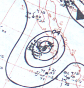
Tropical Storm Kirsten was the eighth tropical cyclone of the 1966 Pacific hurricane season and the second to make landfall in the Baja California peninsula. Forming north of the Intertropical Convergence Zone (ITCZ), Kirsten developed into a tropical depression on September 25 and like Tropical Storm Joyce of the same season, took a long period of time before intensifying into a tropical storm.

<span class="mw-page-title-main">2009 Pacific hurricane season</span>

The 2009 Pacific hurricane season was the most active Pacific hurricane season since 1997. The season officially started on May 15 in the East Pacific Ocean, and on June 1 in the Central Pacific; they both ended on November 30. These dates conventionally delimit the period of each year when most tropical cyclones form in the Eastern Pacific tropical cyclone basin; however, tropical cyclone formation is possible at any time of the year. The first system of the season, Tropical Depression One-E, developed on June 18, and the last, Hurricane Neki, dissipated on October 27, keeping activity well within the bounds of the season.

<span class="mw-page-title-main">Tropical Storm Lowell (2008)</span> Pacific tropical storm in 2008

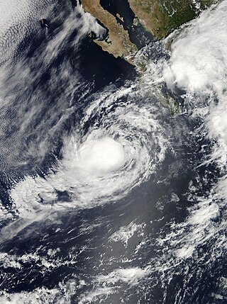
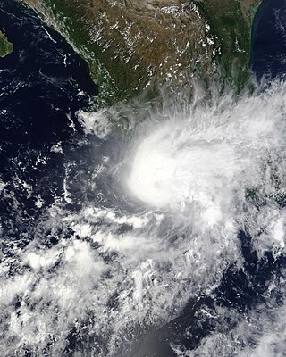
Tropical Storm Lowell was a moderate tropical storm that developed during the 2008 Pacific hurricane season. The fourteenth tropical cyclone and thirteen named storm of the season, Lowell formed out of a western side of a trough on September 6. It quickly intensified into Tropical Storm Lowell, peaking as a moderate tropical storm. It pass directly over Socorro Island and began a weakening trend. It weakened into depression before landfall in Baja California Sur and dissipated before striking Sonora. It later joined with a frontal boundary and Hurricane Ike which caused severe damage as far inland as Chicago. In all, the storm had caused 6 deaths and $15.5 million damage.

<span class="mw-page-title-main">Hurricane Kiko (1989)</span> Category 3 Pacific hurricane in 1989

Hurricane Kiko was one of the strongest tropical cyclones on record to have made landfall on Mexico's Baja California peninsula. The eleventh named storm of the 1989 Pacific hurricane season, Kiko formed out of a large mesoscale convective system on August 25. Slowly tracking northwestward, the storm rapidly intensified into a hurricane early the next day. Strengthening continued until early August 27, when Kiko reached its peak intensity with winds of 120 mph (190 km/h). The storm turned west at this time, and at around 0600 UTC, the storm made landfall near Punta Arena, Mexico at the southern tip of Baja California Sur. The hurricane rapidly weakened into a tropical storm later that day and further into a tropical depression by August 28, shortly after entering the Pacific Ocean. The depression persisted for another day while tracking southward, before being absorbed by nearby Tropical Storm Lorena. Though Kiko made landfall as a Category 3 hurricane, its impact was relatively minor. Press reports indicated that 20 homes were destroyed and numerous highways were flooded by torrential rains.

<span class="mw-page-title-main">Hurricane Raymond (1989)</span> Category 4 Pacific hurricane in 1989

Hurricane Raymond was the strongest tropical cyclone of the 1989 Pacific hurricane season, peaking as a strong Category 4 hurricane on the Saffir–Simpson hurricane scale. Forming out of a tropical wave on September 25, 1989, the tropical depression slowly tracked northwest before becoming nearly stationary the next day. Shortly after, the depression intensified into Tropical Storm Raymond and took a general westward track. Gradually intensifying, Raymond attained hurricane-status on September 28 and attained its peak intensity on September 30, with winds of 145 mph (233 km/h) and a barometric pressure of 935 mbar. Steady weakening then took place and by October 3, Raymond turned northeast towards land. The storm continued to weaken as it accelerated and eventually made landfall on the Baja California Peninsula as a tropical storm late on October 4 and a second landfall in Sonora, Mexico. Shortly after, Raymond weakened to a depression as it tracked inland. The remnants of the system persisted until October 7 when it dissipated over the Central United States.

<span class="mw-page-title-main">Hurricane Jimena (2009)</span> Category 4 Pacific hurricane in 2009

Hurricane Jimena is tied with Hurricane Norbert as the strongest tropical cyclone to make landfall on western portion of the Baja California Peninsula. Jimena was the twelfth named storm, fifth hurricane, third major hurricane and overall second-strongest tropical cyclone of the 2009 Pacific hurricane season. Forming from a tropical wave late on August 28, 2009, off of Mexico's Pacific coast, the system rapidly intensified into a Category 2 hurricane on the next day. Two days after developing, Jimena strengthened into a Category 4 hurricane. After peaking close to Category 5 intensity on September 1, it encountered cold water and began to weaken. When the hurricane made landfall on the Baja California Peninsula on September 3, it was only a Category 2 hurricane. On the next day, the tropical cyclone entered the Gulf of California, though the storm weakened into a remnant low after looping back eastward towards Baja California. The storm's remnants drifted westward into the Pacific afterward, before dissipating on September 8.

<span class="mw-page-title-main">Hurricane Rick (2009)</span> Category 5 Pacific hurricane in 2009

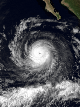
Hurricane Rick was the third-most intense Pacific hurricane on record and the second-most intense tropical cyclone worldwide in 2009, only behind Typhoon Nida. Developing off the southern coast of Mexico on October 15, Rick traversed an area with favorable environmental conditions, favoring rapid intensification, allowing it to become a hurricane within 24 hours of being declared a tropical depression. An eye began to form during the afternoon of October 16; once fully formed, the storm underwent another period of rapid strengthening. During the afternoon of October 17, the storm attained Category 5 status on the Saffir–Simpson hurricane wind scale. Several hours later, Rick attained its peak intensity as the third-strongest Pacific hurricane on record with winds of 180 mph (290 km/h) and a barometric pressure of 906 mbar.

<span class="mw-page-title-main">Hurricane Norbert (1984)</span> Category 4 Pacific hurricane in 1984

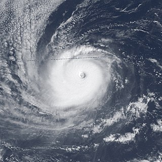
Hurricane Norbert marked the first time a core of a hurricane was fully mapped in three-dimensions. First forming on September 14, 1984 west of the Mexican coast, Norbert gradually intensified, reaching hurricane intensity two days after formation. On September 22, Norbert peaked in strength as a Category 4 hurricane on the Saffir-Simpson Hurricane Scale. While intensifying, Norbert meandered. It moved east, then north, then west, then south, then back towards the east, and finally towards the northeast. After fluctuating in intensity for two more days, Norbert rapidly weakened. It turned towards the northwest and made landfall in southern Baja California Norte as a tropical storm. The combination of Norbert and several other storms left thousands homeless throughout Mexico. The remnants of Hurricane Norbert produced moderate rain over Arizona.

<span class="mw-page-title-main">Hurricane Marty (2015)</span> Pacific tropical cyclone in 2015

Hurricane Marty was a tropical cyclone that produced heavy rains and flooding in several states in Southwestern and Western Mexico. The twentieth named storm and twelfth hurricane of the annual hurricane season, Marty developed from a tropical wave on September 26, 2015, to the southwest of Acapulco, Guerrero, in Mexico. Initially a tropical depression, the system strengthened into a tropical storm early on the following day. Due to favorable atmospheric conditions, Marty continued to intensify, but wind shear sharply increased as the storm approached a large mid- to upper-level trough. Despite this, the cyclone deepened further, becoming a hurricane on September 28 and peaking with sustained winds of 80 mph (130 km/h) shortly thereafter. Wind shear quickly took its toll on the hurricane, weakening it to a tropical storm early on September 29. About 24 hours later, Marty degenerated into a post-tropical low-pressure area offshore Guerrero. The low further degenerated into a trough later on September 30, and eventually dissipated on October 4.

<span class="mw-page-title-main">2018 Pacific hurricane season</span>

The 2018 Pacific hurricane season was one of the most active Pacific hurricane seasons on record, producing the highest accumulated cyclone energy value on record in the basin. The season had the fourth-highest number of named storms – 23, tied with 1982. The season also featured eight landfalls, six of which occurred in Mexico. The season officially began on May 15 in the Eastern Pacific, and on June 1 in the Central Pacific; they both ended on November 30. These dates conventionally delimit the period of each year when most tropical cyclones form in the Pacific basin. However, tropical cyclone formation is possible at any time of the year, as illustrated when the first tropical depression formed on May 10, five days prior to the official start of the season.

<span class="mw-page-title-main">Tropical Storm Sonia (2013)</span>

Tropical Storm Sonia was a weak, late-season tropical cyclone that made a rare landfall in the Mexican state of Sinaloa during early-November 2013.

<span class="mw-page-title-main">Hurricane Norma (2023)</span> Category 4 Pacific hurricane in 2023

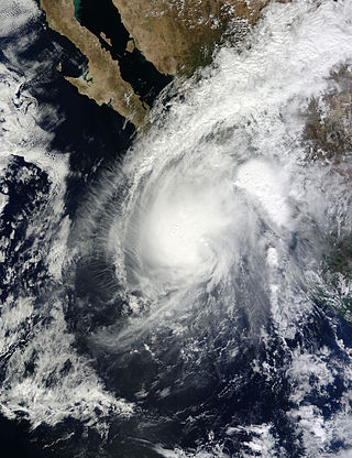
Hurricane Norma was one of four tropical cyclones to strike the Pacific Coast of Mexico in October 2023. The seventeenth tropical depression, fourteenth named storm, ninth hurricane and seventh major hurricane of the 2023 Pacific hurricane season, Norma developed from an area of low pressure that formed off the coast of southern Mexico on October 15, 2023. The disturbance gradually organized as it progressed westward parallel to the coast, and developed into Tropical Storm Norma on October 17. Turning northward, Norma rapidly intensified to a Category 4 hurricane as it continued to parallel the west coast of Mexico. Less favorable environmental conditions caused Norma to gradually weaken as it approached the Baja California peninsula. The cyclone made landfall on the Mexican state of Baja California Sur as a Category 1 hurricane. Norma continued to weaken as it crossed the state. The storm emerged over the Gulf of California on October 22, and made landfall as a tropical depression the following day on the state of Sinaloa. Norma quickly dissipated as it moved inland over Mexico.

References

  1. 1 2 3 4 5 6 7 8 9 10 11 James Franklin (2009-01-07). "Hurricane Norbert: Tropical Cyclone Report" (PDF). National Hurricane Center. Retrieved 2009-09-26.
  2. Beven (2008-09-29). "Tropical Weather Outlook". National Hurricane Center . Retrieved 2008-10-07.[ permanent dead link ]
  3. Stewart (2008-10-04). "Tropical Depression Fifteen Discussion Number 1". National Hurricane Center. Retrieved 2008-10-07.
  4. Roberts (2008-10-04). "Tropical Depression Fifteen Discussion Number 2". National Hurricane Center. Retrieved 2008-10-07.
  5. Lixion Avila (2008-10-04). "Tropical Depression Fifteen Discussion Number 3". National Hurricane Center. Retrieved 2008-10-07.
  6. Stacey Stewart (2008-10-05). "Tropical Storm Norbert Discussion Number 5". National Hurricane Center. Retrieved 2008-10-07.
  7. Robbie Berg/Stacey Stewart (2008-10-06). "Hurricane Norbert Discussion Number 13". National Hurricane Center. Retrieved 2008-10-07.
  8. Micheal Beven (2008-10-07). "Hurricane Norbert Discussion Number 17". National Hurricane Center. Retrieved 2008-10-07.
  9. Lixion Avila (2008-10-08). "Hurricane Norbert Discussion Number 18". National Hurricane Center . Retrieved 2008-10-08.
  10. Lixon Alivia (2008-10-09). "Hurricane Norbert Discussion 22". National Hurricane Center. Retrieved 2008-10-09.
  11. National Hurricane Center; Hurricane Research Division; Central Pacific Hurricane Center (April 26, 2024). "The Northeast and North Central Pacific hurricane database 1949–2023". United States National Oceanic and Atmospheric Administration's National Weather Service. Archived from the original on May 29, 2024. A guide on how to read the database is available here. PD-icon.svg This article incorporates text from this source, which is in the public domain.
  12. John L. Beven (January 29, 2010). "Hurricane Jimena Tropical Cyclone Report" (PDF). National Hurricane Center. Retrieved February 4, 2010.
  13. 1 2 3 "Final Evaluation of Damage Caused by Hurricane Norbert in Baja California Sur" (PDF) (in Spanish). Government of Mexico. November 15, 2008. Retrieved September 4, 2009.
  14. 1 2 Olga R. Rodriguez (October 8, 2008). "Weakening Hurricane Norbert heads for Mexico". USA Today. Associated Press. Retrieved July 18, 2011.
  15. Olga R. Rodriguez (October 10, 2008). "Norbert makes landfall on Mexico's Baja peninsula". USA Today. Associated Press . Retrieved July 18, 2011.
  16. Staff writers (October 9, 2008). "Mexico prepares shelters ahead of Hurricane Norbert". Associated Press . Retrieved July 22, 2011.
  17. 1 2 3 Gladys Rodríguez Navarro (October 16, 2008). "Suman más de 188 mdp daños por Norbert en BCS". El Universal (in Spanish). Archived from the original on June 6, 2011. Retrieved September 4, 2009.
  18. Year 2008 No. 10 (PDF) (Report). Civil Protection. 2009. Retrieved May 8, 2013.
  19. Staff Writer (October 11, 2008). "Hurricane Norbert crashes ashore in northwestern Mexico". Agence France-Presse. Archived from the original on October 8, 2012. Retrieved July 18, 2011.
  20. Susy Buchanan (October 11, 2008). "Hurricane Norbert storms Mexico's Baja peninsula". Ruters. Retrieved July 18, 2011.
  21. Susy Buchanan (October 11, 2008). "Hurricane Norbert Weakens, Nears Mexico Mainland". Associated Press . Retrieved July 18, 2011.
  22. Kelly Ranson (October 11, 2008). "Hurricane Norbert Approaching Coast of Mexico". Cruise Critic. Retrieved July 18, 2011.
  23. Staff Writer (October 14, 2008). "Deja tormenta "Norbert" fuertes daños en Sonora" (PDF) (in Spanish). El Siglo de Durango. Retrieved September 4, 2009.
  24. Susan M. Palmer (Fall 2008). "Hurricane Norbert, Heavy Rains Slam NW Mexico" (PDF) (in Spanish). Evangel. Archived from the original (PDF) on March 27, 2012. Retrieved June 18, 2011.
  25. 1 2 3 La Jornada (October 14, 2008). "Suman 8 Despararecidos por Norbert en Sonroa; Severos Daños en 18 Municipios" (in Spanish). Planeta Azul. Retrieved September 4, 2009.
  26. 1 2 3 Staff Writer (October 14, 2008). "Deja Norbert cuatro muertos y tres desaparecidos en Sonora" (in Spanish). La Jordana. Retrieved September 4, 2009.
  27. 1 2 "Dejan fenómenos naturales daños por 800 mdp en Sonora". La Crónica de Hoy (in Spanish). Notimex. October 14, 2008. Retrieved September 4, 2009.
  28. Gerry Soroka (January 1, 2009). "Alamos: Still a boom to bust town, but with everlasting charm". Mexconnect. Retrieved July 22, 2011.
  29. 1 2 Staff Writer (October 15, 2008). "Norbert provoca pérdidas por 8 millones de pesos en el sector pesquero de Sinaloa" (in Spanish). La Jordana . Retrieved September 4, 2009.
  30. Raymundo Leon; et al. (October 12, 2008). "Norbert lashes Baja California Sur, Sonora and Sinaloa". La Jordana.
  31. "Mexico: Declares emergency SEGOB five municipalities of the State of Sinaloa". Government of Mexico. October 11, 2008. Retrieved September 3, 2011.
  32. "Hurricane Norbert remnants hit West Texas". Associated Press . October 13, 2008. Retrieved August 22, 2011.
  33. "Event Report for New Mexico". National Climatic Data Center. October 11, 2008. Retrieved September 3, 2011.[ permanent dead link ]
  34. "Event Report for New Mexico". National Climatic Data Center. October 11, 2008. Retrieved September 3, 2011.[ permanent dead link ]
  35. "Event Report for New Mexico". National Climatic Data Center. October 11, 2008. Retrieved September 3, 2011.[ permanent dead link ]
  36. "Event Report for New Mexico". National Climatic Data Center. October 11, 2008. Retrieved September 3, 2011.[ permanent dead link ]
  37. "Event Report for New Mexico". National Climatic Data Center. October 11, 2008. Retrieved September 3, 2011.[ permanent dead link ]
  38. "Event Report for New Mexico". National Climatic Data Center. October 11, 2008. Retrieved September 3, 2011.[ permanent dead link ]
Hurricane Norbert
Norbert 2008-10-08 1750Z.jpg
Hurricane Norbert at peak intensity on October 8