JPSS-2

Last updated

JPSS-2
Artist's rendering of NOAA-21.png
Artist's rendering of the JPSS-2 (NOAA-21) satellite in orbit.
NamesNOAA-21
Joint Polar Satellite System-2
Mission type Weather
Operator NOAA
COSPAR ID 2022-150A OOjs UI icon edit-ltr-progressive.svg
SATCAT no. 54234 OOjs UI icon edit-ltr-progressive.svg
Website http://www.jpss.noaa.gov/
Mission duration7 years (planned)
Spacecraft properties
Spacecraft typeJoint Polar Satellite System
Bus LEOStar-3
Manufacturer Northrop Grumman Innovation Systems
Launch mass2,930 kg (6,460 lb)
Start of mission
Launch date10 November 2022, 09:49:00 UTC [1]
Rocket Atlas V 401
Launch site Vandenberg, SLC-3E
Contractor United Launch Alliance
Orbital parameters
Reference system Geocentric orbit (planned)
Regime Sun-synchronous orbit
Altitude833 km
Inclination 98.80°
Period 102.00 minutes
Instruments
Advanced Technology Microwave Sounder (ATMS)
Cross-track Infrared Sounder (CrIS)
Ozone Mapping and Profiler Suite (OMPS)
Visible Infrared Imaging Radiometer Suite (VIIRS)
  NOAA-20
JPSS-3 (NOAA-22) 
 
This visualization illustrates how NOAA-20 orbit phasing and raising works relative to Suomi NPP, the notional way can be maneuvered a quarter-orbit along-track separation from NOAA-20 prior to launch of JPSS-2, and how a three-satellite constellation operates on a Sun-synchronous orbit node-crossing including sensor-swath footprints as the world turns below.

JPSS-2, or Joint Polar Satellite System-2, is the second of the United States National Oceanic and Atmospheric Administration (NOAA)'s latest generation of U.S. polar-orbiting, non-geosynchronous, environmental satellites called the Joint Polar Satellite System. JPSS-2 was launched on 10 November 2022 [1] and join NOAA-20 and Suomi NPP in the same orbit. [2] Circling the Earth from pole-to-pole, it will cross the equator about 14 times daily, providing full global coverage twice a day. [3]

Contents

JPSS-2 will provide operational continuity of satellite-based observations and products for NOAA Polar-Orbiting Environmental Satellites (POES) and Suomi NPP satellite and ground systems. [3] The baseline plan for JPSS Ground System will be sustained to support JPSS-2, similar to NOAA-20. The JPSS-2 spacecraft will host the following instruments: 1) VIIRS, 2) CrIS, 3) ATMS, and 4) OMPS. It was at one time intended to carry the Radiation Budget Instrument (RBI) but NASA cancelled that project in 2018. [4]

Development

On 24 March 2015, NASA announced that Orbital ATK would build one, and possibly three, Joint Polar Satellite System spacecraft. In winning the contract, Orbital unseated the incumbent Ball Aerospace & Technologies which had built NOAA-20 (JPSS-1) and Suomi NPP. [5] JPSS-2 is based on Orbital ATK's LEOStar-3 spacecraft bus platform, which was also used on Landsat 8. The second Ice, Cloud and Land Elevation satellite (ICESat-2) and the Landsat 9 spacecraft are also based on the LEOStar-3 and are being built at Orbital ATK's Gilbert facility at the same time. [6]

The launch services contract was awarded to United Launch Alliance (ULA) on 3 March 2017. [7]

Launch

JPSS-2 was launched on 10 November 2022 on an Atlas V 401 rocket from Vandenberg Space Launch Complex 3 (SLC-3E) at Vandenberg Space Force Base in California. It was the final launch of an Atlas V from Vandenberg Space Force Base. [1]

JPSS-2's launch day had been pushed back a couple of times. In May of 2022 it slipped a little more than a month when VIIRS experienced a test equipment anomaly during thermal vacuum (TVAC) testing. [8] It slipped again from November 1st following ULA discovering that the battery on the Atlas V's Centaur upper stage needed to be replaced. [9] Launch and activation was hampered by a solar array deployment failure that was detected a few hours after launch. [10]

Instruments

The JPSS-2 sensors/instruments are: [3]

Advanced Technology Microwave Sounder (ATMS)

The Advanced Technology Microwave Sounder (ATMS) is a cross-track scanner with 22 channels. It provides sounding observations needed to retrieve atmospheric moisture and temperature profiles for real-time civilian weather forecasting and to provide continuity of these measurements for climate monitoring. It is a lighter-weight version of the previous Advanced Microwave Sounding Unit (AMSU) and Microwave Humidity Sounder (MHS) instruments flown on previous NOAA and NASA satellites with no new performance capabilities. [11]

Cross-track Infrared Sounder (CrIS)

The Cross-track Infrared Sounder (CrIS) instrument will be used to produce high-resolution, three-dimensional moisture, pressure, and temperature profiles. These profiles will help scientists to enhance weather forecasting models, and will be used in both short- and long-term weather forecasting. They will help improve the understanding of regular climate phenomena such as El Niño and La Niña. This is a brand-new instrument with breakthrough performance. [12] CrIS represents a significant enhancement over NOAA's legacy infrared sounder — High Resolution Infrared Radiation Sounder (HIRS) and is meant to be a counterpart to the Infrared Atmospheric Sounding Interferometer (IASI).

Ozone Mapping and Profiler Suite (OMPS)

The Ozone Mapping and Profiler Suite (OMPS) is a suite of three hyperspectral instruments that is extending the 25-plus year total-ozone and ozone-profile records. Ozone-assessment researchers and policy makers use these records to track the health of the ozone layer. Better testing and monitoring of the complex chemistry involved in ozone destruction near the troposphere is made possible by the improved vertical resolution of OMPS data products. OMPS products, when used with cloud predictions, also produce better ultraviolet index forecasts. [13] OMPS carries on a long tradition of space borne measurements of ozone beginning in 1970 with the Nimbus 4 satellite and continuing with the Solar Backscatter Ultraviolet (SBUV and SBUV/2), Total Ozone Mapping Spectrometer (TOMS) and Ozone Monitoring Instrument (OMI) instruments on various NASA, NOAA, and international satellites. Over the more than 30-year period in which these instruments have been operating, they have provided a very detailed and important long-term record of the global distribution of ozone. [14]

Visible Infrared Imaging Radiometer Suite (VIIRS)

The Visible Infrared Imaging Radiometer Suite (VIIRS) takes global visible and infrared observations of land, ocean, and atmosphere parameters at high temporal resolution. Developed from the Moderate Resolution Imaging Spectroradiometer (MODIS) instrument flown on the Aqua and Terra Earth Observing System (EOS) satellites, it has significantly better performance than the Advanced very-high-resolution radiometer (AVHRR) previously flown on NOAA satellites. [15] VIIRS Focal Planes were manufactured by Raytheon Vision Systems in Santa Barbara, CA

Discontinued instruments

Radiation Budget Instrument (RBI)

The Radiation Budget Instrument (RBI) was a planned scanning radiometer capable of measuring Earth's reflected sunlight and emitted thermal radiation. RBI was to fly on JPSS-2, but it experienced significant technical issues and substantial cost growth. Because of these challenges, and the low risk of experiencing a gap in this data record due to having two relatively new instruments in orbit at the time, NASA decided to discontinue development of RBI. [4] RBI struggled from the beginning. It was originally to be on NOAA's proposed Polar Free Flyer satellite, but in 2014, Congress, led by its Republican majority, refused to fund the satellite. After moving the instrument to JPSS-2 and awarding the contract for development in June 2014, [16] NASA almost immediately began the process of dropping the sensor. NASA halted development in 2015 citing cost and technical concerns. [17] In 2017, it was defunded in the Trump administration's first budget because of "schedule and technical difficulties". [18] RBI got a brief reprieve when the Senate stated that if NASA determined that RBI could be ready for inclusion on the Joint Polar Satellite System 2 (JPSS-2) spacecraft and stay within budget it could continue with reprogrammed funding. [19] But on 26 January 2018, NASA announced their intention to discontinue development of RBI and shortly thereafter it was again left unfunded in the Trump administration's FY 2019 budget. [4] [20]

Related Research Articles

<span class="mw-page-title-main">Advanced microwave sounding unit</span> Instrument installed on meteorological satellites

The advanced microwave sounding unit (AMSU) is a multi-channel microwave radiometer installed on meteorological satellites. The instrument examines several bands of microwave radiation from the atmosphere to perform atmospheric sounding of temperature and moisture levels.

<span class="mw-page-title-main">Advanced very-high-resolution radiometer</span>

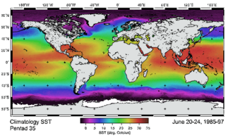
The Advanced Very-High-Resolution Radiometer (AVHRR) instrument is a space-borne sensor that measures the reflectance of the Earth in five spectral bands that are relatively wide by today's standards. AVHRR instruments are or have been carried by the National Oceanic and Atmospheric Administration (NOAA) family of polar orbiting platforms (POES) and European MetOp satellites. The instrument scans several channels; two are centered on the red (0.6 micrometres) and near-infrared (0.9 micrometres) regions, a third one is located around 3.5 micrometres, and another two the thermal radiation emitted by the planet, around 11 and 12 micrometres.

<span class="mw-page-title-main">NOAA-19</span>

NOAA-19, known as NOAA-N' before launch, is the last of the American National Oceanic and Atmospheric Administration (NOAA) series of weather satellites. NOAA-19 was launched on 6 February 2009. NOAA-19 is in an afternoon equator-crossing orbit and is intended to replace NOAA-18 as the prime afternoon spacecraft.

<span class="mw-page-title-main">NOAA-17</span>

NOAA-17, also known as NOAA-M before launch, was an operational, polar orbiting, weather satellite series operated by the National Environmental Satellite Service (NESS) of the National Oceanic and Atmospheric Administration (NOAA). NOAA-17 also continued the series of Advanced TIROS-N (ATN) spacecraft begun with the launch of NOAA-8 (NOAA-E) in 1983 but with additional new and improved instrumentation over the NOAA A-L series and a new launch vehicle.

<span class="mw-page-title-main">NOAA-16</span>

NOAA-16, also known as NOAA-L before launch, was an operational, polar orbiting, weather satellite series operated by the National Environmental Satellite Service (NESS) of the National Oceanic and Atmospheric Administration (NOAA). NOAA-16 also continued the series of Advanced TIROS-N (ATN) spacecraft begun with the launch of NOAA-8 (NOAA-E) in 1983 but with additional new and improved instrumentation over the NOAA A-K series and a new launch vehicle.

<span class="mw-page-title-main">NOAA-18</span>

NOAA-18, also known as NOAA-N before launch, is an operational, polar orbiting, weather satellite series operated by the National Environmental Satellite Service (NESS) of the National Oceanic and Atmospheric Administration (NOAA). NOAA-18 also continued the series of Advanced TIROS-N (ATN) spacecraft begun with the launch of NOAA-8 (NOAA-E) in 1983 but with additional new and improved instrumentation over the NOAA A-M series and a new launch vehicle. NOAA-18 is in an afternoon equator-crossing orbit and replaced NOAA-17 as the prime afternoon spacecraft.

<span class="mw-page-title-main">NOAA-15</span>

NOAA-15, also known as NOAA-K before launch, is an operational, polar-orbiting of the NASA-provided Television Infrared Observation Satellite (TIROS) series of weather forecasting satellite operated by National Oceanic and Atmospheric Administration (NOAA). NOAA-15 was the latest in the Advanced TIROS-N (ATN) series. It provided support to environmental monitoring by complementing the NOAA/NESS Geostationary Operational Environmental Satellite program (GOES).

The Polar-orbiting Operational Environmental Satellite (POES) was a constellation of polar orbiting weather satellites funded by the National Oceanic and Atmospheric Administration (NOAA) and the European Organisation for the Exploitation of Meteorological Satellites (EUMETSAT) with the intent of improving the accuracy and detail of weather analysis and forecasting. The spacecraft were provided by NASA and the European Space Agency (ESA), and NASA's Goddard Space Flight Center oversaw the manufacture, integration and test of the NASA-provided TIROS satellites. The first polar-orbiting weather satellite launched as part of the POES constellation was the Television Infrared Observation Satellite-N (TIROS-N), which was launched on 13 October 1978. The final spacecraft, NOAA-19, was launched on 6 February 2009. The ESA-provided MetOp satellite operated by EUMETSAT utilize POES-heritage instruments for the purpose of data continuity. The Joint Polar Satellite System, which was launched on 18 November 2017, is the successor to the POES Program.

Ozone Mapping and Profiler Suite (OMPS), is a suite of instruments built by Ball Aerospace that measure the global distribution of ozone and, less frequently, how it is distributed vertically within the stratosphere. The suite flies on the Suomi NPP and NOAA-20 satellites along with several other instruments. It had been intended to also fly on the NPOESS, for which the NPP was a preparatory project, but the dissolution of that project was announced in 2010. OMPS launched on October 28, 2011.

<span class="mw-page-title-main">NOAA-7</span>

NOAA-7, known as NOAA-C before launch, was an American operational weather satellite for use in the National Operational Environmental Satellite System (NOESS) and for the support of the Global Atmospheric Research Program (GARP) during 1978-1984. The satellite design provided an economical and stable Sun-synchronous platform for advanced operational instruments to measure the atmosphere of Earth, its surface and cloud cover, and the near-space environment. An earlier launch, NOAA-B, was scheduled to become NOAA-7, however NOAA-B failed to reach its required orbit.

NOAA-6, known as NOAA-A before launch, was an American operational weather satellite for use in the National Operational Environmental Satellite System (NOESS) and for the support of the Global Atmospheric Research Program (GARP) during 1978-1984. The satellite design provided an economical and stable Sun-synchronous platform for advanced operational instruments to measure the atmosphere of Earth, its surface and cloud cover, and the near-space environment.

<span class="mw-page-title-main">Joint Polar Satellite System</span> Constellation of American meteorology satellites

The Joint Polar Satellite System (JPSS) is the latest generation of U.S. polar-orbiting, non-geosynchronous, environmental satellites. JPSS will provide the global environmental data used in numerical weather prediction models for forecasts, and scientific data used for climate monitoring. JPSS will aid in fulfilling the mission of the U.S. National Oceanic and Atmospheric Administration (NOAA), an agency of the Department of Commerce. Data and imagery obtained from the JPSS will increase timeliness and accuracy of public warnings and forecasts of climate and weather events, thus reducing the potential loss of human life and property and advancing the national economy. The JPSS is developed by the National Aeronautics and Space Administration (NASA) for the National Oceanic and Atmospheric Administration (NOAA), who is responsible for operation of JPSS. Three to five satellites are planned for the JPSS constellation of satellites. JPSS satellites will be flown, and the scientific data from JPSS will be processed, by the JPSS – Common Ground System (JPSS-CGS).

<span class="mw-page-title-main">Suomi NPP</span>

The Suomi National Polar-orbiting Partnership, previously known as the National Polar-orbiting Operational Environmental Satellite System Preparatory Project (NPP) and NPP-Bridge, is a weather satellite operated by the United States National Oceanic and Atmospheric Administration (NOAA). It was launched in 2011 and continues to operate in June 2022.

<span class="mw-page-title-main">Visible Infrared Imaging Radiometer Suite</span>

The Visible Infrared Imaging Radiometer Suite (VIIRS) is a sensor designed and manufactured by the Raytheon Company on board the polar-orbiting Suomi National Polar-orbiting Partnership and NOAA-20 weather satellite. VIIRS is one of five key instruments onboard Suomi NPP, launched on October 28, 2011. VIIRS is a whiskbroom scanner radiometer that collects imagery and radiometric measurements of the land, atmosphere, cryosphere, and oceans in the visible and infrared bands of the electromagnetic spectrum.

<span class="mw-page-title-main">Radiation Budget Instrument</span>

The Radiation Budget Instrument (RBI) is a scanning radiometer capable of measuring Earth's reflected sunlight and emitted thermal radiation. The project was cancelled on January 26, 2018; NASA cited technical, cost, and schedule issues and the impact of anticipated RBI cost growth on other programs.

<span class="mw-page-title-main">NOAA-20</span> NASA satellite

NOAA-20, designated JPSS-1 prior to launch, is the first of the United States National Oceanic and Atmospheric Administration's latest generation of U.S. polar-orbiting, non-geosynchronous, environmental satellites called the Joint Polar Satellite System. NOAA-20 was launched on 18 November 2017 and joined the Suomi National Polar-orbiting Partnership satellite in the same orbit. NOAA-20 operates about 50 minutes ahead of Suomi NPP, allowing important overlap in observational coverage. Circling the Earth from pole-to-pole, it crosses the equator about 14 times daily, providing full global coverage twice a day. This gives meteorologists information on "atmospheric temperature and moisture, clouds, sea-surface temperature, ocean color, sea ice cover, volcanic ash, and fire detection" so as to enhance weather forecasting including hurricane tracking, post-hurricane recovery by detailing storm damage and mapping of power outages.

<span class="mw-page-title-main">NOAA-9</span>

NOAA-9, known as NOAA-F before launch, was an American weather satellite operated by the National Oceanic and Atmospheric Administration (NOAA) for use in the National Environmental Satellite Data and Information Service (NESDIS). It was the second of the Advanced TIROS-N series of satellites. The satellite design provided an economical and stable Sun-synchronous platform for advanced operational instruments to measure the atmosphere of Earth, its surface and cloud cover, and the near-space environment.

NOAA-10, known as NOAA-G before launch, was an American weather satellite operated by the National Oceanic and Atmospheric Administration (NOAA) for use in the National Environmental Satellite Data and Information Service (NESDIS). It was the third of the Advanced TIROS-N series of satellites. The satellite design provided an economical and stable Sun-synchronous platform for advanced operational instruments to measure the atmosphere of Earth, its surface and cloud cover, and the near-space environment.

NOAA-11, known as NOAA-H before launch, was an American weather satellite operated by the National Oceanic and Atmospheric Administration (NOAA) for use in the National Operational Environmental Satellite System (NOESS) and for support of the Global Atmospheric Research Program (GARP) during 1978–1984. It was the fourth of the Advanced TIROS-N series of satellites. The satellite design provided an economical and stable Sun-synchronous platform for advanced operational instruments to measure the atmosphere of Earth, its surface and cloud cover, and the near-space environment.

NOAA-12, also known as NOAA-D before launch, was an American weather satellite operated by National Oceanic and Atmospheric Administration (NOAA), an operational meteorological satellite for use in the National Environmental Satellite, Data, and Information Service (NESDIS). The satellite design provided an economical and stable Sun-synchronous platform for advanced operational instruments to measure the atmosphere of Earth, its surface and cloud cover, and the near-space environment.

References

  1. 1 2 3 Gebhardt, Chris (10 November 2022). "Atlas rocket bids farewell to California as ULA readies for Vulcan". NASASpaceFlight . Retrieved 10 November 2022.
  2. "NOAA's JPSS-2 Mission Has New Launch Date". NESDIS . NOAA. 31 May 2022. Retrieved 31 May 2022.
  3. 1 2 3 "Joint Polar Satellite System: Mission and Instruments". NASA. Retrieved 14 November 2017.PD-icon.svg This article incorporates text from this source, which is in the public domain .
  4. 1 2 3 "NASA Cancels Earth Science Sensor Set for 2021 Launch". 26 January 2018. Retrieved 14 February 2018.PD-icon.svg This article incorporates text from this source, which is in the public domain .
  5. "Orbital ATK Wrests JPSS Business From Ball". SpaceNews. 23 March 2015. Retrieved 13 February 2018.
  6. Datta, Anasuya (20 March 2018). "Orbital ATK to start manufacturing Landsat 9 as spacecraft passes critical design review" . Retrieved 22 March 2018.
  7. Cole, Steve (3 March 2017). "NASA Awards Launch Services Contract for Joint Polar Satellite System-2 Mission". NASA. Retrieved 13 April 2018.PD-icon.svg This article incorporates text from this source, which is in the public domain .
  8. "NOAA's JPSS-2 Mission Has New Launch Date" . Retrieved 18 November 2022.
  9. "Centaur issue delays JPSS-2 launch" . Retrieved 18 November 2022.
  10. Foust, Jeff. "JPSS-2 deploys solar array after dela" . Retrieved 18 November 2022.
  11. The Advanced Technology Microwave Sounder NASA Goddard Spaceflight Center Retrieved 22 June 2017 PD-icon.svg This article incorporates text from this source, which is in the public domain .
  12. "The Cross-track Infrared Sounder" Archived August 7, 2011, at the Wayback Machine NASA Goddard Spaceflight Center Retrieved 22 June 2017
  13. "Ozone Mapper Profiler Suite". NASA. Archived from the original on 17 March 2011. Retrieved 22 June 2017.PD-icon.svg This article incorporates text from this source, which is in the public domain .
  14. "Ozone Mapping Profiler Suite (OMPS)". Archived from the original on 20 April 2018. Retrieved 22 March 2018.PD-icon.svg This article incorporates text from this source, which is in the public domain .
  15. "The Visible Infrared Imaging Radiometer Suite" NASA Goddard Spaceflight Center Retrieved 22 June 2017
  16. Scharmann, Rachel (3 June 2014). "Exelis Secures Contract for NASA Radiation Budget Instrument". Satellite Today. Retrieved 14 February 2018.
  17. "NASA Weather Satellite Procurement Telegraphed Issue with Climate Sensor". SpaceNews. 11 June 2015. Retrieved 14 February 2018.
  18. Wall, Mike (24 May 2017). "Trump's 2018 Budget Request Axes 5 NASA Earth-Science Missions". Space.com. Retrieved 14 February 2018.
  19. Foust, Jeff (27 June 2017). "Senate restores funding for NASA Earth science and satellite servicing programs". SpaceNews. Retrieved 14 February 2018.
  20. Wall, Mike (12 February 2018). "Trump's 2019 NASA Budget Request Puts Moon Ahead of Space Station". Space.com. Retrieved 14 February 2018.