Lambert's Castle

Last updated

Lambert's Castle
Lambert's Castle 1.jpg
Lambert's Castle, seen from the east
Dorset UK location map.svg
Archaeological site icon (red).svg
Location of the site in Dorset
Location Dorset, England
Coordinates 50°47′14″N2°53′42″W / 50.78713°N 2.89509°W / 50.78713; -2.89509
History
Periods Iron Age
Site notes
Ownership National Trust
Public accessYes, Open Access Land
Official nameLambert's Castle: an Iron Age hillfort 425m west of Nash Farm, with a bowl barrow, and the sites of a post-medieval fair and a telegraph station
Designated26 August 1924
Reference no.1017035

Lambert's Castle is an Iron Age hillfort in the county of Dorset in southwest England. [1] Since 1981 it has been designated as a Site of Special Scientific Interest (SSSI) on account of its geology, archaeology and ecology. [2] The hillfort is designated a scheduled monument together with a bowl barrow, the sites of a post-medieval fair and a telegraph station. [3] The site was on the Heritage at Risk Register but was removed in 2022 as a result of the Hillforts and Habitats Project. [4]

Contents

3D view of the digital terrain model Lamberts Castle Digital Terrain Model.jpg
3D view of the digital terrain model

The hillfort is situated on a broad northerly spur at the summit of Lambert's Castle Hill, which rises to a height of 256 metres (840 ft). There are steep natural slopes on three sides of the fort, and linear ramparts across the flat southern approaches. The site is owned by the National Trust. A car park is accessible from the B3165 road. There are two other hill-forts near Lambert's Castle: Coney's Castle is about 1.5 kilometres (0.9 mi) to its south, and Pilsdon Pen is about 5 km (3.1 mi) to its north-east.

History

Lamberts Castle was built around 2,500 years ago; a prominent ditch and bank still survive near the western entrance. A fair was held here from 1709 to 1947, during which the hilltop was used as a racecourse. [1]

Geology

The site consists of sands and marls of the middle Lias with the remains of Gault and Upper Greensand capping. There are strong outflows of springs at various junctions of the upper greensand and gault.

Ecology

Plateau surface of Upper Greensand

This is a mosaic of acidic grassland, open heath, scrubland and secondary woodland and comprises: sheep-fescue ( Festuca ovina ), sweet vernal-grass ( Anthoxanthum odoratum ), early hair-grass ( Aira praecox ), heath-grass ( Danthonia decumbens ) and field wood-rush ( Luzula campestris ). Herbs present include abundant tormentil ( Potentilla erecta ), heath milkwort ( Polygala serpyllifolia ), cats-ear ( Hypochaeris radicata ), heath bedstraw ( Galium saxatile ), heather ( Calluna vulgaris ), bell heather ( Erica cinerea ), bristle bent ( Agrostis curtisii ), bilberry ( Vaccinium myrtillus ), bryophytes, lichen, gorse ( Ulex europaeus ), western gorse ( Ulex gallii ), bramble ( Rubus fruticosus ), bracken ( Pteridium aquilinum ), birch ( Betula spp.), hawthorn ( Crataegus monogyna ), rowan ( Sorbus aucuparia ) and pedunculate oak ( Quercus robur ).

Upper Greensand / Gault junction

A zone of acidic bog vegetation consisting of: purple moor-grass ( Molinia caerulea ), common cottongrass ( Eriophorum angustifolium ), sedges ( Carex spp.) including star sedge ( Carex echinata ), green-ribbed sedge ( Carex binervis ) and flea sedge ( Carex pulicaris ); bog moss ( Sphagnum spp.), heath spotted-orchid ( Dactylorhiza maculata ), devils-bit scabious ( Succisa pratensis ), bog asphodel ( Narthecium ossifragum ), marsh violet ( Viola palustris ), meadow thistle ( Cirsium dissectum ), wood horsetail ( Equisetum sylvaticum ), lesser butterfly-orchid ( Platanthera bifolia ) and pale butterwort ( Pinguicula lusitanica ).

Lower slopes

Unimproved, herb-dominated neutral grassland consisting of: crested dogstail ( Cynosurus cristatus ), common knapweed ( Centaurea nigra ), red fescue ( Festuca rubra ), yellow oat-grass ( Trisetum flavescens ), quaking grass ( Briza media ), spring-sedge ( Carex caryophyllea ), glaucous sedge ( Carex flacca ), red clover ( Trifolium pratense ), ox-eye daisy ( Leucanthemum vulgare ), common bird-foot-trefoil ( Lotus corniculatus ). Less frequent species are lady's-mantle ( Alchemilla vulgaris ), dyer's greenweed ( Genista tinctoria ), corky-fruited water-dropwort ( Oenanthe pimpinelloides ) and adders-tongue ( Ophioglossum vulgatum ).

Wet areas in grassland

Soft rush ( Juncus effusus ), sharp-flowered rush ( Juncus acutiflorus ), oval sedge ( Carex leporina ), common yellow-sedge ( Carex demissa ), carnation sedge ( Carex panicea ), common marsh-bedstraw ( Galium palustre ), marsh pennywort ( Hydrocotyle vulgaris ), ragged-robin ( Lychnis flos-cuculi ), greater birds-foot-trefoil ( Lotus uliginosus ), bog pimpernel ( Anagallis tenella ) and bristle clubrush ( Isolepis setacea ).

Notable invertebrates

Related Research Articles

<span class="mw-page-title-main">Aire Point to Carrick Du SSSI</span> Site of Special Scientific Interest in Cornwall, England

Aire Point to Carrick Du SSSI is a Site of Special Scientific Interest on the Penwith Peninsula, Cornwall, England. It is 5.98 square kilometres in extent, stretching from grid reference SW360279 to grid reference SW513410. The site is designated both for its biological and its geological interest.

<span class="mw-page-title-main">Caha Mountains</span> Low mountains in County Cork, Ireland

The Caha Mountains are a range of low sandstone mountains on the Beara peninsula in south-west County Cork, Ireland. The highest peak is Hungry Hill, at 685 m (2,247 ft). Other notable peaks include Knocknagree, Sugarloaf Mountain, Eskatarriff, Knocknaveacal, Derryclancy, Nareera, Killane Mountain and Baurearagh Mountain.

Yanal Bog is a 1.6 hectare biological Site of Special Scientific Interest on the southern edge of the North Somerset Levels, just north of the village of Sandford, North Somerset. It was notified as an SSSI in 1988.

<span class="mw-page-title-main">Bratton Downs</span>

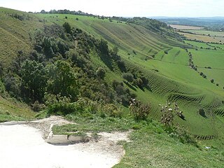
Bratton Downs is a 395.8 hectare biological and geological Site of Special Scientific Interest in Wiltshire, England, near the villages of Bratton and Edington, and about 3 miles (5 km) east of the town of Westbury. It was notified in 1971. The designated area consists mainly of chalk grassland, as well as some ancient woodland, and supports a diverse range of native flora and fauna. It overlays notable geological features—principally landforms created by glaciation in the Pleistocene.

NVC community CG2 is one of the calcicolous grassland communities in the British National Vegetation Classification system. It is one of three short-sward communities associated with heavy grazing, within the lowland calcicolous grassland group, and is regarded as "typical" chalk grassland.

<span class="mw-page-title-main">Scotstown Moor</span>

Scotstown Moor is in the north of Aberdeen, Scotland.

NVC community CG5 is one of the calcicolous grassland communities in the British National Vegetation Classification system. It is one of four communities of rank, tussocky grassland associated with low levels of grazing, within the lowland calcicolous grassland group.

<span class="mw-page-title-main">Purple moor grass and rush pastures</span> One of UKs natural habitats

Purple moor grass and rush pastures is a type of Biodiversity Action Plan habitat in the UK. It occurs on poorly drained neutral and acidic soils of the lowlands and upland fringe. It is found in the South West of England, especially in Devon.

<span class="mw-page-title-main">Waldridge Fell</span>

Waldridge Fell is a Site of Special Scientific Interest located immediately south-west of Chester-le-Street in the northern part of County Durham, England. It is one of the largest areas of lowland heath in County Durham and contains the only lowland valley-mire in the county. The fell is home to a number of plants and insects that are scarce to rare elsewhere in the county.

<span class="mw-page-title-main">Hunder Beck Juniper</span>

Hunder Beck Juniper is a Site of Special Scientific Interest in the Teesdale district of south-west County Durham, England. It lies between the Balderhead and Blackton Reservoirs and adjoins the Cotherstone Moor SSSI to the south.

<span class="mw-page-title-main">Pow Hill Bog</span> Protected natural area in County Durham, England

Pow Hill Bog is a Site of Special Scientific Interest in the Wear Valley district of County Durham, England. It lies alongside Derwent Reservoir, approximately 2 km north-west of the village of Edmundbyers and adjacent to the Edmundbyers Common portion of the Muggleswick, Stanhope and Edmundbyers Commons and Blanchland Moor SSSI.

<span class="mw-page-title-main">Cefn Blaenau</span> Site of Special Scientific Interest in Wales

Cefn Blaenau is a 23-hectare Site of Special Scientific Interest in a small upland valley in Carmarthen and Dinefwr, Wales. It was designated an SSSI in 1989, primarily for its flush and spring vegetation as well as the diverse mosaic of unimproved pasture, ‘ffridd’ land, marshy grassland, wet heath, acid grassland, broadleaved woodland, streams, and small rock outcrops. These habitats, which are well represented at this site, have been greatly reduced in north Carmarthenshire due to land improvement, agricultural intensification, and afforestation. Only about 140 hectares of flush and spring vegetation remain in the county.

<span class="mw-page-title-main">Chyenhal Moor</span> Site of Special Interest in Cornwall

Chyenhal Moor is a poorly drained shallow valley, 2 miles (3.2 km) to the south-west of Penzance, Cornwall. Due to several rare plants in a diverse range of habitats, it was notified as a Site of Special Scientific Interest (SSSI) in 1951.

<span class="mw-page-title-main">Allendale Moors</span>

Allendale Moors is a Site of Special Scientific Interest (SSSI) in Northumberland, England. The upland moorland ridge site is listed for its heath, flush and upland grassland which provide a habitat for a nationally important assemblage of moorland breeding birds.

Bamburgh Coast and Hills is the name given to a Site of Special Scientific Interest (SSSI) on the coast of north Northumberland, England. The site is one of the longest-standing SSSIs in England, having been listed since 1954, and displays the interaction of a fluid magma rock, now known as the Whin Sill, interacting with older sedimentary rock. Coastal erosion at the site enables sections of the geological strata to be seen. In turn, the soil associated with the Whin Sill gives rise to a distinct pattern of vegetation which on its own merits is at this site found notable.

Barrow Burn Meadows is a Site of Special Scientific Interest (SSSI) in north Northumberland, England. The site is a species-rich hay meadow of a sort now rare in Northumberland.

<span class="mw-page-title-main">Bewick and Beanley Moors</span>

Bewick and Beanley Moors is the name given to a Site of Special Scientific Interest (SSSI) in north Northumberland, in the north-east of England. The moors are asserted to be of national importance by Natural England for the extent, quality and diversity of upland types including heaths, fens, wet grassland, flushes, mires and blanket bogs, together creating an extensive mosaic habitat supporting an exceptional community of amphibians. The moors are important, too, for their relict juniper woodland and scrub.

Ashford Hill is a British national nature reserve next to the village of Ashford Hill in Hampshire. Part of the reserve is a designated a Site of Special Scientific Interest (SSSI). The site is one of Natural Englands nature reserves

References

  1. 1 2 Lamberts Castle, Dorset: Walk of the week at www.telegraph.co.uk. Accessed on 22 Mar 2013.
  2. "SSSI detail". designatedsites.naturalengland.org.uk. Retrieved 1 December 2021.
  3. Historic England. "Lambert's Castle: an Iron Age hillfort 425m west of Nash Farm, with a bowl barrow, and the sites of a post-medieval fair and a telegraph station, Marshwood (1017035)". National Heritage List for England . Retrieved 1 December 2021.
  4. "'Fine condition': Hillforts no longer 'at risk' after protection work". Bridport and Lyme Regis News. Retrieved 4 April 2022.