List of Pennsylvania state historical markers in Elk County

Last updated

Location of Elk County in Pennsylvania Map of Pennsylvania highlighting Elk County.svg
Location of Elk County in Pennsylvania

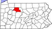
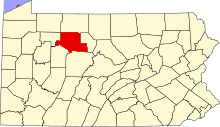
This is a list of the Pennsylvania state historical markers in Elk County.

Contents

This is intended to be a complete list of the official state historical markers placed in Elk County, Pennsylvania by the Pennsylvania Historical and Museum Commission (PHMC). The locations of the historical markers, as well as the latitude and longitude coordinates as provided by the PHMC's database, are included below when available. There are 4 historical markers located in Elk County. [1]

Map all coordinates using: OpenStreetMap  
Download coordinates as: KML

Historical markers

Marker titleImageDate dedicatedLocationMarker typeTopics
Elk County Ridgway PA from Country Club Apr 10.JPG July 22, 1982County Courthouse, South Main Street, Ridgway
41°25′18″N78°43′48″W / 41.421794°N 78.729916°W / 41.421794; -78.729916 (Elk County)
CityEnvironment, Government & Politics, Government & Politics 19th Century
First State Game Lands TransparentPlaceholder.png October 20, 1950Glen Hazel Road, south of Bendigo Road, Wilcox
41°32′04″N78°36′26″W / 41.5345°N 78.60728°W / 41.5345; -78.60728 (First State Game Lands)
RoadsideEnvironment, Government & Politics 20th Century
Iroquois "Main Road" TransparentPlaceholder.png October 7, 1950PA 66 & 948, Highland Township, Johnsonburg (MISSING)
RoadsideAfrican American, French & Indian War, Military, Native American
St. Marys St Marys City Hall Apr 10.JPG n/aSt. Mary's Street (PA 255) & State Street (PA 120) near the Diamond, St. Marys
41°25′42″N78°33′41″W / 41.42838°N 78.56133°W / 41.42838; -78.56133 (St. Marys)
RoadsideCities & Towns, Ethnic & Immigration, Religion

See also

References

  1. "PHMC Historical Markers Search" (Searchable database). Pennsylvania Historical and Museum Commission. Commonwealth of Pennsylvania. Retrieved 2010-07-19.