This is a list of notable districts and neighborhoods of the city of Los Angeles, California, present and past.

Beverly Hills is a city in Los Angeles County, California. Located within 5.71 square miles (14.8 km2) and surrounded by the cities of Los Angeles and West Hollywood, it had a population of 34,109 at the 2010 census and an estimated population of 33,792 in 2019.

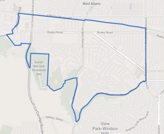
View Park−Windsor Hills is an unincorporated community in Los Angeles County, California.

Brentwood is a neighborhood in the Westside of Los Angeles, California, United States.

Westwood is a commercial and residential neighborhood in the northern central portion of the Westside region of Los Angeles, California. It is the home of the University of California, Los Angeles (UCLA). Bordering the campus on the south is Westwood Village, a major regional district for shopping, dining, movie theaters, and other entertainment – from the 1930s through the 1980s, it was the most popular such district on the Westside.

The Los Angeles Westside is an urban region in western Los Angeles County, California. It has no official definition, but sources like LA Weekly and the Mapping L.A. survey of the Los Angeles Times place the region on the western side of the Los Angeles Basin south of the Santa Monica Mountains.
West Los Angeles is an area within the city of Los Angeles, California. The residential and commercial neighborhood is divided by the Interstate 405 freeway, and each side is sometimes treated as a distinct neighborhood, mapped differently by different sources. Each lies within the larger Westside region of Los Angeles County.

Baldwin Hills is a neighborhood within the South Los Angeles region of Los Angeles California. It is home to Kenneth Hahn State Regional Park and to Village Green, a National Historic Landmark.

East Hollywood is a densely populated neighborhood of 78,000+ residents in the central region of Los Angeles, California. It is notable for being the site of Los Angeles City College, Barnsdall Park and a hospital district. There are seven public and five private schools, as well as a branch of the Los Angeles Public Library and three hospitals. Almost two-thirds of the people living there were born outside the United States and 90% were renters. In 2000 the neighborhood had high percentages of never-married people and of single parents.

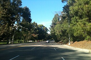
Wilshire Boulevard is one of the principal east-west arterial roads in the Los Angeles area of Southern California, extending 15.83 miles (25.48 km) from Ocean Avenue in the city of Santa Monica east to Grand Avenue in the Financial District of downtown Los Angeles. It is also one of the major city streets through the city of Beverly Hills. Wilshire Boulevard runs roughly parallel with Santa Monica Boulevard from Santa Monica to the west boundary of Beverly Hills. From the east boundary it runs a block south of Sixth Street to its terminus.
Elysian Park is a neighborhood in Central Los Angeles, California, with a mostly low-income community of 2,600+ people. A city park, Elysian Park, and Dodger Stadium are within the neighborhood, as are a Catholic high school and an elementary school.
Mid-Wilshire is a neighborhood in the central region of Los Angeles, California. It is known for the Los Angeles County Museum of Art, the Petersen Automotive Museum, and the Miracle Mile shopping district.
Central Los Angeles is the historic urban region of Los Angeles County, California.

The Historic Preservation Overlay Zone of the City of Los Angeles in California has been hailed by historic preservation advocates for its pioneering program, which designates not just buildings but entire neighborhoods or districts as worthy of historic preservation.

Beverly Crest is a neighborhood in the Santa Monica Mountains, in the Westside area of the city of Los Angeles, California.

Northwest Los Angeles or Northwest of Downtown is a group of neighborhoods near the central area of Los Angeles, California that are north and west of the city center of Los Angeles, California. This name for the area has been in use off and on for over 100 years, originally applying to Angelino Heights and gradually shifting northwesterly as those areas were built out.
Los Angeles City Council District 10 is one of the 15 districts of the Los Angeles City Council.
Baldwin Hills/Crenshaw is a neighborhood in the city of Los Angeles within the south region of the city. It is divided between the upscale, principally home-owning Baldwin Hills residential district to the south and a more concentrated apartment area to the north, just south of Jefferson Boulevard. A commercial corridor along Crenshaw Boulevard has the Baldwin Hills Crenshaw Plaza, Marlton Square and Crenshaw Boulevard restaurants.

Hollywood Hills West is a neighborhood within Central Los Angeles, California. There are three city parks and one elementary school.
Beverly Grove is a neighborhood within the Beverly–Fairfax neighborhood in the Mid-City West area of Los Angeles, California.
| By topic |  | |
|---|---|---|
| Government | ||