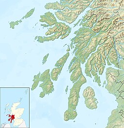
The Firth of Clyde is the estuary of the River Clyde, on the west coast of Scotland. The Firth has some of the deepest coastal waters of the British Isles. The Firth is sheltered from the Atlantic Ocean by the Kintyre Peninsula. The Firth lies between West Dunbartonshire in the north, Argyll and Bute in the west and Inverclyde, North Ayrshire and South Ayrshire in the east. The Kilbrannan Sound is a large arm of the Firth, separating the Kintyre Peninsula from the Isle of Arran. The Kyles of Bute separates the Isle of Bute from the Cowal Peninsula. The Sound of Bute separates the islands of Bute and Arran.
Cowal is a rugged peninsula in Argyll and Bute, on the west coast of Scotland. It is connected to the mainland to the north, and is bounded by Loch Fyne to the west, by Loch Long and the Firth of Clyde to the east, and by the Kyles of Bute to the south.
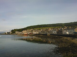
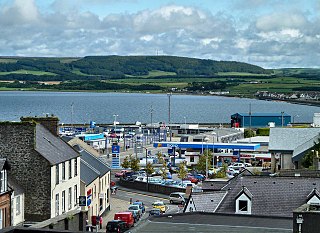
Port Bannatyne, is a coastal village on the Isle of Bute, Firth of Clyde, Scotland that is home to many steamers. Port Bannatyne developed into the 1900s as a quieter alternative to Rothesay. It is a popular harbour, with a small yacht marina and boatyard and an unusual 13-hole golf course rather than the standard 18.

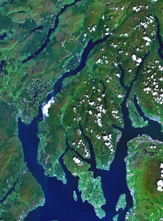
The Kyles of Bute form a narrow sea channel that separates the northern end of the Isle of Bute from the Cowal Peninsula in Argyll and Bute, on the Scottish mainland. The surrounding hillsides are roughly wooded, and overlooked by rocky tops and areas of moorland.

Bunessan, meaning "bottom of the waterfall", is a small village on the Ross of Mull, a peninsula in the south-west of the Isle of Mull, off the west coast of Scotland. The settlement is at OS grid reference NM382218, within the parish of Kilfinichen and Kilvickeon, and is situated on the A849, at the head of a cove at the southern end of Loch na Làthaich.

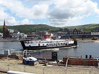
Colintraive is a village on the Cowal Peninsula, in Argyll and Bute, west of Scotland. Once the site where cattle were swum across the narrows to the Isle of Bute, the MV Loch Dunvegan — a ferry operated by Caledonian MacBrayne — now provides a link to the island.

Holm is a small residential area in the south of the city of Inverness, Scotland. The area lies east of the River Ness.
Mochrum is a coastal civil and Church of Scotland parish situated to the east of Luce Bay on the Machars peninsula and 8 miles (13 km) southwest of Wigtown and in the historical county of Wigtownshire in Galloway, Scotland. It covers 22,000 acres (8,900 ha) and is approximately 10 miles (16 km) in length and 5 miles (8.0 km) in breadth. The parish contains the eponymous village of Mochrum, as well as Port William and the clachan of Elrig.

Ascog is a small village on the Isle of Bute, within Argyll and Bute council area, Scotland. The village is within the parish of Kingarth, and is situated on the A844. It is located on the east coast of the island, about 2 km to the south east of Rothesay. It is largely residential.
Glasserton is a civil parish in Dumfries and Galloway, south-west Scotland. It is on the Machars peninsula, in the traditional county of Wigtownshire. The parish is about 8 miles (13 km) in length, varying in breadth from 1 to 3 miles, and contains 13,477 acres (54.54 km2).

Eilean Dearg is a small island in Loch Ruel in Argyll, Scotland. The island was once home to a castle, which was destroyed by naval action in Argyll's Rising in 1685. No visible remains of the castle are to be found, but archaeologists excavated the site between 1964 and 1967, finding the castle's hall, chapel, a tower and the foundations of the wall, along with a gate. The excavations also found vitrified rock, possibly indicating the island was once occupied by a vitrified fort.

Clairinsh or Clairinch is an island in Loch Lomond, central Scotland.
MV Loch Riddon is a Caledonian Maritime Assets Limited ro-ro car ferry, built in 1986 and operated by Caledonian MacBrayne. After the first eleven years of her life in the Kyles of Bute, she served at Largs between 1997 and 2013. After a short spell as the Lismore vessel she returned to Largs in June 2014.
Inch is a civil parish in Dumfries and Galloway, southwest Scotland. It lies on the shore of Loch Ryan, in the traditional county of Wigtownshire.
Old Luce is a civil parish in Dumfries and Galloway, Scotland. It lies in the Machars peninsula, in the traditional county of Wigtownshire. The parish is around 10 miles (16 km) long and 8 miles (13 km) broad, and contains 40,350 acres (16,330 ha).

Rosneath Peninsula is a peninsula in Argyll and Bute, western Scotland, formerly in the historic county of Dunbartonshire. The peninsula is formed by the Gare Loch in the east, and Loch Long in the west, both merge with the upper Firth of Clyde.

Inverchaolain Church is a former Church of Scotland church building in Inverchaolain, Cowal, Argyll and Bute, Scotland. Located on the eastern shores of Loch Striven, just north of Inverchaolain Burn, the church was built in 1912. It is the fourth church on the site. There is a possibility that the second church, rumoured to be dedicated to Saint Bridget, was located about 200 metres (660 ft) northeast of the present structure.

River Ruel is a watercourse in Argyll and Bute, Scotland. Around 9 miles (14 km) long, it flows into Loch Ruel.