
Victoria Island is a large island in the Arctic Archipelago that straddles the boundary between Nunavut and the Northwest Territories of Canada. It is the eighth-largest island in the world, and at 217,291 km2 (83,897 sq mi)1 in area, it is Canada's second-largest island. It is nearly double the size of Newfoundland (111,390 km2 [43,010 sq mi]), and is slightly larger than the island of Great Britain (209,331 km2 [80,823 sq mi]) but smaller than Honshu (225,800 km2 [87,200 sq mi]). The western third of the island lies in the Inuvik Region of the Northwest Territories; the remainder is part of Nunavut's Kitikmeot Region. The population of 2,168 is divided between two settlements, the larger of which is Cambridge Bay (Nunavut) and the other Ulukhaktok.

The Arctic Archipelago, also known as the Canadian Arctic Archipelago, is an archipelago lying to the north of the Canadian continental mainland, excluding Greenland and Iceland.
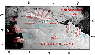
The Abbot Ice Shelf is an ice shelf 250 nautical miles long and 40 nautical miles wide, bordering Eights Coast from Cape Waite to Pfrogner Point in Antarctica. Thurston Island lies along the northern edge of the western half of this ice shelf; other sizable islands lie partly or wholly within this shelf.
Wasagamack First Nation is an Oji-Cree First Nation band government in Manitoba, Canada. As of December 2014 the registered population of the Wasagamack First Nation was 2,017, of which 1,823 lived on their own reserve.

Rongé Island is a high, rugged island 5 nautical miles long, the largest island of the group which forms the west side of Errera Channel, off the west coast of Graham Land in Antarctica.

The Prince of Wales Strait is a strait in the Northwest Territories of Canada separating Banks Island to the northwest from Victoria Island to the southeast. It extends from Viscount Melville Sound in the northeast to Amundsen Gulf in the southwest. From late winter it is filled by ice that usually does not break up until August, if at all. Its namesake, Prince of Wales Island, lies over 200 mi (320 km) to the east.

The locality Port Leopold is an abandoned trading post in the Qikiqtaaluk Region of Nunavut, Canada. It faces Prince Regent Inlet at the northeast tip of Somerset Island.

St. Theresa Point First Nation is a First Nations community in northern Manitoba. It has 3 reserves in total, the largest and most populated of which is St. Theresa Point, which is bordered by the unorganized portion of Division No. 22, Manitoba, and by the Wasagamack First Nation.

Dustin Island is an island about 18 nautical miles long, lying 15 nautical miles southeast of Cape Annawan, Thurston Island. The island forms the southeast limit of Seraph Bay.
The Ferguson River originates on the eastern bank of Ferguson LakeA within the northern Hearne Domain, Western Churchill province of the Churchill craton, the northwest section of the Canadian Shield in Nunavut's Kivalliq Region.

The Parry Channel is a natural waterway through the central Canadian Arctic Archipelago. Its eastern two-thirds lie in the territory of Nunavut, while its western third lies in the Northwest Territories. It runs east to west, connecting Baffin Bay in the east with the Beaufort Sea in the west. Its eastern end is the only practical entrance to the Northwest Passage. Its western end would be a natural exit from the archipelago were it not filled with ice. The channel separates the Queen Elizabeth Islands to the north from the rest of Nunavut.
Opingivik Island is an uninhabited Baffin Island offshore island located in the Arctic Archipelago in Nunavut's Qikiqtaaluk Region. It lies in Cumberland Sound between Ikpit Bay to the north and Robert Peel Inlet approximately 18.6 km (11.6 mi) to the south.
Aston Bay is an Arctic waterway in the Qikiqtaaluk Region of Nunavut, Canada. It is an arm of Peel Sound and is located on the western side of Somerset Island. It is located north of M'Clure Bay. The closest hamlet is Resolute, located about 150 km (93 mi) to the north on Cornwallis Island.
Birmingham Bay is an Arctic waterway in the Qikiqtaaluk Region, Nunavut, Canada. It is an arm of Peel Sound and is located on the western side of Somerset Island. It is located north of M'Clure Bay. The closest hamlet is Resolute, located about 148 km (92 mi) to the north on Cornwallis Island.

Dobbin Bay is an Arctic waterway in the Qikiqtaaluk Region, Nunavut, Canada. It is located in the Kane Basin, Nares Strait by eastern Ellesmere Island, south of the Darling Peninsula.
The Butler Glacier is a broad glacier draining the north side of Edward VII Peninsula in the vicinity of Clark Peak, and flowing generally northeastward through the Alexandra Mountains to its terminus in Sulzberger Bay.

Croft Bay is a bay which indents the north-central side of James Ross Island and forms the southern part of Herbert Sound, south of the northeastern end of the Antarctic Peninsula.

The La Loche River is a small river in north-west Saskatchewan. The distance from its source at the south east end of Lac La Loche to its mouth at the north end of Peter Pond Lake is 56 km. The river is bridged by Highway 956 about 5 kilometres from its source. The Kimowin River flows in from the west.
Bone Bay is a rectangular bay along the northwest coast of Trinity Peninsula, Antarctica. It is nearly 10 nautical miles wide at the entrance between Notter Point and Cape Roquemaurel.
