
Martin's Haven is a small, north-facing cove in Pembrokeshire, Wales, UK, on the Dale Peninsula, with views across St Bride's Bay towards St David's. It is recorded by the Royal Commission as a historic place name. [1]
Martin's Haven is a small, north-facing cove in Pembrokeshire, Wales, UK, on the Dale Peninsula, with views across St Bride's Bay towards St David's. It is recorded by the Royal Commission as a historic place name. [1]
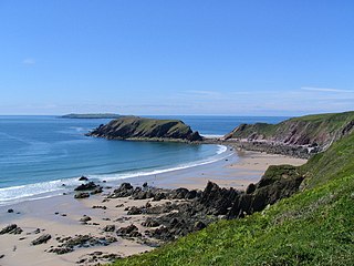
The Haven's shingle beach has a stone slipway which acts as an embarkation point for the ferry which visits the nearby island of Skomer, a national nature reserve, during summer. Martin's Haven lies within the Skomer Marine Conservation Zone and is popular for scuba diving and attractive for its dark sky. [2] Grey seals can be seen basking on the rocks.
The Haven is on the Pembrokeshire Coast Path and in the Pembrokeshire Coast National Park. It has its own car park and toilet facilities, owned by the National Trust, as is much of the small peninsula on which Martin's Haven lies. [3] [4] [5] The National Trust area features a peninsula walk from which most of Pembrokeshire's islands can be seen. [6]
For sailors and divers there is safe anchorage at Martin's Haven for small boats, with the mouth of the cove having 6 metres of water. Onshore is a Wildlife Trust visitor centre. [7] On the west side of the Haven, at Wooltack Point, there is a National Coastwatch Institution watch station. [8]
When constructing the visitor toilets 100m inland from the Haven, workmen found an inscribed stone with a ring-cross, whose possible original function in the 9th or 10th centuries was as a marker or prayer station for travellers; the Haven is a well-established landing place from Skomer, which has been occupied since before recorded history. [9]

The Pembrokeshire Coast Path, often called the Pembrokeshire Coastal Path, is a designated National Trail in Pembrokeshire, southwest Wales. Established in 1970, it is a 186-mile (299 km) long-distance walking route, mostly at cliff-top level, with a total of 35,000 feet (11,000 m) of ascent and descent. At its highest point – Pen yr afr, on Cemaes Head – it reaches a height of 574 feet (175 m), and at its lowest point – Sandy Haven crossing, near Milford Haven – it is just 6 feet (2 m) above low water. Whilst most of the coastline faces west, it offers – at varying points – coastal views in every direction of the compass.

Pembrokeshire is a county in the south-west of Wales. It is bordered by Carmarthenshire to the east, Ceredigion to the northeast, and otherwise by the sea. Haverfordwest is the largest town and administrative headquarters of Pembrokeshire County Council.

Pembrokeshire Coast National Park is a national park along the Pembrokeshire coast in west Wales.

Skokholm or Skokholm Island is an island 2.5 miles (4.0 km) off the coast of Pembrokeshire, Wales, south of the neighbouring island of Skomer. The surrounding waters are a marine reserve and all are part of the Pembrokeshire Coast National Park. Both islands are listed as Sites of Special Scientific Interest.

Skomer or Skomer Island is an island off the coast of Pembrokeshire, in the community of Marloes and St Brides in west Wales. It is well known for its wildlife: around half the world's population of Manx shearwaters nest on the island, the Atlantic puffin colony is the largest in southern Britain, and the Skomer vole is unique to the island. Skomer is a national nature reserve, a Site of Special Scientific Interest and a Special Protection Area. It is surrounded by a marine nature reserve and is managed by the Wildlife Trust of South and West Wales.
Gateholm or Gateholm Island is a small tidal island off the south west coast of Pembrokeshire, in the community of Marloes and St Brides, in the south west side of Wales, in the west of the UK, and about 8 miles (13 km) west of the port of Milford Haven. It is known for its Romano-British remains. Gateholm is owned by the National Trust as part of their Marloes Sands and Mere estate.

Middleholm, also known as Midland Isle, is a small island lying off southwest Pembrokeshire in Wales, between the island of Skomer and the mainland in the community of Marloes and St Brides. It is roughly circular with a diameter of about 1,210 feet (370 m) and an area of 21.5 acres (8.7 ha). It is separated from the mainland by Jack Sound and from Skomer by Little Sound.

St Brides Bay is a bay in western Pembrokeshire, West Wales.

Bedd Arthur is a possibly Neolithic hengiform monument megalithic site in the Preseli Hills in the Welsh county of Pembrokeshire. Thirteen upright stones and at least 2 fallen ones, each around 0.6 metres (2.0 ft) high form an oval horseshoe with similarities to the earliest form of Stonehenge.

Porthclais is a small sheltered inlet harbour near St Davids, Pembrokeshire, Wales, in the community of St Davids and the Cathedral Close.

Cwm-yr-Eglwys is a hamlet in a picturesque cove on the eastern side of the Dinas Island peninsula in the community of Dinas Cross between Fishguard and Newport, Pembrokeshire, in southwest Wales. It has a full-time population of around 10 people. There are 27 homes and a small private caravan site.

The Diocese of St Davids is a diocese of the Church in Wales, a church of the Anglican Communion. The diocese covers the historic extent of Ceredigion, Carmarthenshire and Pembrokeshire, together with a small part of western Glamorgan. The episcopal see is the Cathedral Church of St David in the City of St Davids, Pembrokeshire. The present cathedral, which was begun in 1181, stands on the site of a monastery founded in the 6th century by Saint David.
Marloes is a village and parish in Pembrokeshire, Wales, on the Marloes Peninsula 7 miles (11 km) west of Milford Haven and forms the western tip of the southern shore of St Brides Bay. It is within part of the Pembrokeshire Coast National Park. The parish has 6 miles (9.7 km) of mainland coastline accessible throughout by the Pembrokeshire Coast Path and, together with St Brides, constitutes the community of Marloes and St Brides. In 2001, the population was 323.

Jack Sound is a treacherous body of water between the island of Skomer and the Pembrokeshire coast in west Wales. It is popular with divers.

Marloes and St. Brides is a community in the West Wales county of Pembrokeshire. It lies on the Pembrokeshire Coast Path and in the Pembrokeshire Coast National Park.
Skomer Marine Conservation Zone is an underwater marine nature reserve located off the coast of Pembrokeshire in Wales. The nature reserve completely surrounds the islands of Skomer and Middleholm, and encompasses the mainland coastline around the end of the Marloes peninsula, including the small bay of Martin's Haven.
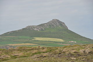
Carn Llidi is a hill east of St David's Head in Pembrokeshire, Wales. Carn Llidi and its surrounding area is part of the Pembrokeshire Coast National Park.

The coastline of Wales extends from the English border at Chepstow westwards to Pembrokeshire then north to Anglesey and back eastwards to the English border once again near Flint. Its character is determined by multiple factors, including the local geology and geological processes active during and subsequent to the last ice age, its relative exposure to or shelter from waves, tidal variation and the history of human settlement and development which varies considerably from one place to another. The majority of the coast east of Cardiff in the south, and of Llandudno in the north, is flat whilst that to the west is more typically backed by cliffs. The cliffs are a mix of sandstones, shales and limestones, the erosion of which provides material for beach deposits. Of the twenty-two principal areas which deliver local government in Wales, sixteen have a coastline, though that of Powys consists only of a short section of tidal river some distance from the open sea. Its length has been estimated at 1,680 miles (2,700 km).
The geology of Pembrokeshire in Wales inevitably includes the geology of the Pembrokeshire Coast National Park which extends around the larger part of the county's coastline and where the majority of rock outcrops are to be seen. The park was established as a national park in 1952. Pembrokeshire's bedrock geology is largely formed from a sequence of sedimentary and igneous rocks originating during the late Precambrian and the Palaeozoic era, namely the Ediacaran, Cambrian, Ordovician, Silurian, Devonian and Carboniferous periods, i.e. between 635 and 299 Ma. The older rocks in the north of the county display patterns of faulting and folding associated with the Caledonian Orogeny. On the other hand, the late Palaeozoic rocks to the south owe their fold patterns and deformation to the later Variscan Orogeny.