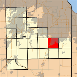
Monee Township | |
---|---|
Coordinates: 41°25′28″N87°43′25″W / 41.42444°N 87.72361°W | |
Country | United States |
State | Illinois |
County | Will |
Established | November 6, 1849 |
Government | |
• Supervisor | Donna T. Dettbarn |
Area | |
• Total | 35.87 sq mi (92.9 km2) |
• Land | 35.8 sq mi (92.72 km2) |
• Water | 0.07 sq mi (0.18 km2) 0.20% |
Elevation | 774 ft (236 m) |
Population (2010) | |
• Estimate (2016) [1] | 15,490 |
• Density | 437.7/sq mi (169.0/km2) |
Time zone | UTC-6 (CST) |
• Summer (DST) | UTC-5 (CDT) |
ZIP codes | 60417, 60449, 60466, 60484 |
Area code | 708 |
FIPS code | 17-197-49958 |
Website | www |
Monee Township is one of 24 townships in Will County, Illinois. As of the 2010 census, its population was 15,669 and it contained 6,182 housing units. [2] Monee Township used to be known as Carcy Township, but the name was changed at an unknown date.
After the 1832 Treaty of Tippecanoe, daughters of Marie Bailly, an Odawa or Potawatomi woman, were granted 1,280 acres of land in Monee Township surrounding the site of today's Raccoon Grove Nature Preserve. [3] [4] The reservation was purchased by William B. Ogden of Chicago in 1851. [5] [6]
On May 26, 1917, Monee Township was hit by a devastating cyclone. The cyclone, which appeared to have multiple tornadoes, was visible from neighboring Peatone, and left a two to three mile wide path of destruction as it moved from west to east through Will County. Crops were damaged, and at least 50 horses and 100 cattle were killed in Monee and Green Garden townships. The cyclone destroyed multiple homes, wrecked an Illinois Central freight train, drove the water out of Monee Reservoir, and made the road through the wooded picnic grounds at Raccoon Grove impassible. Many trees were downed in the village of Monee, but most structures were spared. [7]
According to the 2010 census, the township has a total area of 35.87 square miles (92.9 km2), of which 35.8 square miles (93 km2) (or 99.80%) is land and 0.07 square miles (0.18 km2) (or 0.20%) is water. [2] It includes all of Monee, almost all of University Park as well as a small portion of Park Forest.
Monee Township is bordered by Western Avenue on the east, Steger Road on the north (where Cook County and Will County share a border), Harlem Avenue on the west, and Offner Road on the south.
The township contains the Saint Paul's United Church of Christ Cemetery.
Census | Pop. | Note | %± |
---|---|---|---|
2016 (est.) | 15,490 | [1] | |
U.S. Decennial Census [8] |
Will County is a county in the northeastern part of the state of Illinois. According to the 2020 census, it had a population of 696,355, an increase of 2.8% from 677,560 in 2010, making it Illinois's fourth-most populous county. The county seat is Joliet. Will County is one of the five collar counties of the Chicago–Naperville–Elgin, IL–IN–WI Metropolitan Statistical Area. The portion of Will County around Joliet uses area codes 815 and 779, while 630 and 331 are for far northern Will County and 708 is for central and eastern Will County.
Kane County is a county in the U.S. state of Illinois. According to the 2020 census, it has a population of 516,522, making it the fifth-most populous county in Illinois. Its county seat is Geneva, and its largest city is Aurora. Kane County is one of the collar counties of the metropolitan statistical area designated "Chicago–Naperville–Elgin, IL–IN–WI" by the US census.
Monee is a village in Will County, Illinois, United States, a south suburb of Chicago. The population was 5,128 at the 2020 census.
Addison Township is one of nine townships in DuPage County, Illinois, USA. As of the 2020 census, its population was 88,351 and it contained 32,306 housing units.
Bremen Township is one of 29 townships in Cook County, Illinois, USA. As of the 2020 census, its population was 107,149 and it contained 42,611 housing units. It was organized in 1850 and is located southwest of Chicago in southern Cook County. An administrative office for Bremen Township is located at 16361 South Kedzie Parkway, Markham, Illinois. It is named after the State of the same name in Germany as this area was settled by primarily German settlers.
Barrington Township is one of 29 townships in Cook County, Illinois, USA. As of the 2020 census, its population was 16,514 and it contained 6,172 housing units. The northwestern corner of the Cook County panhandle, it is the county's northwesternmost township. It is also by far the least densely populated township in the county, with less than half the population density of the next least Lemont Township.
Bloom Township is one of 29 townships in Cook County, Illinois, USA. As of the 2020 census, its population was 86,018 and it contained 33,964 housing units.
Calumet Township is one of 29 townships in Cook County, Illinois, United States. As of the 2020 census, its population was 18,609 and it contained 8,210 housing units.
Elk Grove Township is one of 29 townships in Cook County, Illinois, USA. As of the 2020 census, its population was 95,508 and it contained 40,299 housing units. Elk Grove Township formerly housed the United Airlines headquarters.
Lemont Township is one of 29 townships in Cook County, Illinois, USA. As of the 2020 census, its population was 22,645 and it contained 8,580 housing units.
Leyden Township is one of 29 townships in Cook County, Illinois, USA. As of the 2020 census, its population was 93,096 and it contained 35,824 housing units.
Lyons Township is one of 29 townships in Cook County, Illinois. As of the 2020 census, its population was 115,105, with its most populous municipalities including La Grange, Justice and Summit. Lyons Township was established in 1850. The village of Lyons, almost all of which lies within the township, is often confused with it.
Orland Township is one of 29 townships in Cook County, Illinois, USA. As of the 2020 census, its population was 98,246.
Palatine Township is one of 29 townships in Cook County, Illinois, United States. As of the 2020 census, its population was 114,403. It is the north central township of the six northwest townships that form the Cook County panhandle. Palatine Township was organized in 1850.
Palos Township is one of 29 townships in Cook County, Illinois. As of the 2020 census, its population was 56,836, with its most populous municipality being Palos Hills. The vast majority of the township's population resides in its eastern half; the half west of La Grange Road consists of the Palos Forest Preserves, a section of the Cook County Forest Preserves. In 1850 the small town of Trenton, Illinois changed its name to Palos; this recommendation was made by M.S. Powell, the local postmaster, whose ancestor supposedly sailed with Christopher Columbus from Palos de la Frontera. When it incorporated as a village in 1914, Palos officially became Palos Park. Nearby communities incorporated later: Hickory Hills, in 1951, and Palos Hills, in 1958. All three municipalities lie completely or substantially within Palos Township. Palos Heights, partially in Worth Township, incorporated in 1959.
Proviso Township is one of 29 townships in Cook County, Illinois, United States. As of the 2020 census, its population was 151,209. It was organized in 1850 and originally named "Taylor", but shortly afterward its name was changed to make reference to the Wilmot Proviso, a contemporary piece of legislation intended to stop the spread of slavery.
Rich Township is one of 29 townships in Cook County, Illinois, United States located south of Chicago. As of the 2020 census, its population was 76,138. Richton Park serves as the governmental seat for the township.
Schaumburg Township is one of 29 townships in Cook County, Illinois, USA. As of the 2020 census, its population was 134,809. It is in the north west corner of Cook County.
Frankfort Township is one of 24 townships in Will County, Illinois. As of the 2010 census, its population was 57,055 and it contained 19,720 housing units.
Green Garden Township is located in Will County, Illinois, between the villages of Manhattan and Monee and straight south of Frankfort. The center of the township is the intersection of Manhattan-Monee and Center roads. From the center, the township extends three miles (5 km) in each direction; north, west, south, and east, for a total of 36 square miles (93 km2).