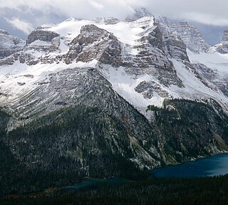
Mount Hungabee, officially Hungabee Mountain, is a mountain located on the boundaries of Banff National Park and Yoho National Park on the Continental Divide at the head of Paradise Valley, in Canada. The peak was named in 1894 by Samuel Allen after the Stoney Indian word for "chieftain" as the mountain is higher than its neighbouring peaks. The mountain can be seen from the Icefields Parkway (#93) in the upper Bow Valley.

Deltaform Mountain is one of the mountains in the Valley of the Ten Peaks, located on the Continental Divide on the border of British Columbia and Alberta, and also on the border between Banff and Kootenay National Parks in Canada. The mountain was originally named Saknowa by Samuel Allen but Walter Wilcox named it to its official title in 1897 as it resembles the Greek letter delta.
Mount Smythe is a mountain in Jasper National Park, Alberta, Canada.

Mount Saskatchewan is a mountain located in the North Saskatchewan River valley of Banff National Park, in the Canadian Rockies of Alberta, Canada.

Mount Hector is a 3,394-metre (11,135-foot) mountain summit located in the Bow River valley of Banff National Park, in the Canadian Rockies of Alberta, Canada. The mountain was named in 1884 by George M. Dawson after James Hector, a geologist on the Palliser expedition. The mountain is located beside the Icefields Parkway, 17 km (11 mi) north of Lake Louise.

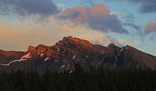
The Vermilion Range is a mountain range of the Canadian Rockies, in Banff National Park, Canada. The range is east of the Sawback Range and west of the Bare and Palliser Ranges.

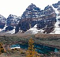
Mount Allen is a mountain in the Canadian Rockies, on the Continental Divide, which forms the provincial boundary between British Columbia and Alberta in this region. J. Monroe Thorington named this mountain for Samuel Evans Stokes Allen in 1924. Allen was an American cartographer who mapped this area of the Rockies in 1894–1895. Allen had named this mountain "Shappee", the Stoney language word for "six", as part of his naming of the ten mountains in the Valley of the Ten Peaks. The peak forms part of the backdrop to Moraine Lake in Banff National Park.

Division Mountain is located on the Continental Divide along the Alberta - British Columbia border of Canada. It also straddles the shared boundary of Banff National Park with Kootenay National Park in the Canadian Rockies. It was named in 1919 by Charles D. Walcott since the mountain divides the Lyell Icefield from the Mons Icefield.

Mount Habel is a 3,073-metre (10,082-foot) mountain summit located in Banff National Park on the Continental Divide along the border of Alberta and British Columbia in the Waputik Mountains, part of the Canadian Rockies. It was named in 1986 after Jean Habel. Jean Habel was a German geographer who explored the Canadian Rockies and in 1897 was the first to set foot on the Wapta Icefield which surrounds Mount Habel.

Mount Olive is located N of the head of the Yoho River on the Continental Divide, on the Alberta-British Columbia border, in both Banff National Park and Yoho National Park. It lies on the eastern edge of the Wapta Icefield, and is part of the Waputik Mountains. It was named in 1898 by H.B. Dixon after his wife Dixon, Olive.

Mount Bowlen is located on the border of Alberta and British Columbia and forms part of the Valley of the Ten Peaks. It was named in 1953 after John J. Bowlen, a native of Prince Edward Island, successful Alberta rancher, honorary chief of the Blackfoot, and a Lieutenant Governor of Alberta. Its former name was "Yamnee", which translates to the number 3 in the local Nakoda (Stoney) language.

Mount Perren is located on the border of Alberta and British Columbia on the Continental Divide. It was named in 1968 after Walter Perren, a Swiss climbing guide and Parks Canada service warden. The peak forms part of the backdrop to Moraine Lake in the Valley of the Ten Peaks of Banff National Park.
Wonder Peak is located on the border of Alberta and British Columbia in the Canadian Rockies. Situated on the Continental Divide, it also straddles the shared boundary of Banff National Park with Mount Assiniboine Provincial Park. It was named in 1913 by Arthur O. Wheeler and Conrad Kain.

The Towers is a 2,842-metre (9,324-foot) mountain located on the border of Alberta and British Columbia on the Continental Divide. It also straddles the shared boundary of Banff National Park with Mount Assiniboine Provincial Park. It was named in 1917 by Arthur O. Wheeler. Its nearest higher peak is Mount Magog, 2.5 km (1.6 mi) to the west.

Mount Magog is located on the border of Alberta and British Columbia on the Continental Divide in the Canadian Rockies. It also straddles the shared boundary of Banff National Park with Mount Assiniboine Provincial Park. It was named in 1930 after references in the Bible.
Mount Gloria is located on the border of Alberta and British Columbia on the Continental Divide in Canada. It was named in 1913 by the Interprovincial Boundary Survey after Lake Gloria which lies directly north of the mountain.

Aye Mountain is located on the Canadian provincial boundary between Alberta and British Columbia on the Continental Divide. It was named in 1913 by the Interprovincial Boundary Survey.

Castleguard Mountain, also known as Mount Castleguard, is an isolated mountain located near the southern edge of the Columbia Icefield at the northern edge of Banff National Park in Alberta, Canada. In 1918, Irish land surveyor Arthur Oliver Wheeler named the mountain because of its castle-like appearance, which seemed to stand guard over the southern portion of the Columbia Icefield. Castleguard was first ascended in 1919 by the Interprovincial Boundary Commission, which determined the exact location of the boundary between British Columbia and Alberta along the continental divide.
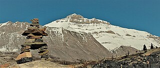
Nigel Peak is a 3,211-metre (10,535-foot) mountain summit located on the shared border of Banff National Park and Jasper National Park, in the Canadian Rockies of Alberta, Canada. Nigel has two peaks, the north summit is the highest point. The nearest higher peak is Mount Athabasca, 6.4 km (4.0 mi) to the south-southwest. Nigel Peak is situated immediately north of Sunwapta Pass and can be seen from the Icefields Parkway and from Athabasca Glacier. Topographic relief is significant as the summit rises 1,100 metres (3,609 ft) above the parkway in two kilometres (1.2 mile).

Mount Nestor is a 2,970-metre (9,740 ft) mountain summit located in Kananaskis Country in the Canadian Rockies of Alberta, Canada. It is named after HMS Nestor, a destroyer sunk in the Battle of Jutland during World War I. Mount Nestor is situated at the south end of the Goat Range along the west shore of Spray Lakes Reservoir. Nestor's east flank is within Spray Valley Provincial Park, while the west aspect is within Banff National Park, with the boundary line between the two parks running roughly north-to-south over its summit. The nearest higher peak is Old Goat Mountain, 2.0 km (1.2 mi) to the north. Mount Nestor can be seen from Alberta Highway 742, the Smith-Dorrien/Spray Trail.