
Mount Columbia is a mountain located in the Winston Churchill Range of the Rocky Mountains. It is the highest point in Alberta, Canada, and is second only to Mount Robson for height and topographical prominence in the Canadian Rockies. It is located on the border between Alberta and British Columbia on the northern edge of the Columbia Icefield. Its highest point, however, lies within Jasper National Park in Alberta.

Mount Woolley is a mountain in Alberta, Canada, located in the Sunwapta River Valley of Jasper National Park, 1½ km south of Diadem Peak and is part of Winston Churchill Range of the Canadian Rockies.

Mount Saskatchewan is a mountain located in the North Saskatchewan River valley of Banff National Park, in the Canadian Rockies of Alberta, Canada.

Mount Victoria, 3,464 metres (11,365 ft), is a mountain on the border between British Columbia and Alberta in the Canadian Rockies. It is located just northeast of Lake O'Hara in Yoho National Park and is also part of Banff National Park and is on the Continental Divide. The mountain has two peaks, the south being the highest while the north peak is slightly lower at 3,388 metres (11,115 ft).

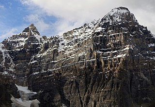
Mount Allen is a mountain in the Canadian Rockies, on the Continental Divide, which forms the provincial boundary between British Columbia and Alberta in this region. J. Monroe Thorington named this mountain for Samuel Evans Stokes Allen in 1924. Allen was an American cartographer who mapped this area of the Rockies in 1894–1895. Allen had named this mountain "Shappee", the Stoney language word for "six", as part of his naming of the ten mountains in the Valley of the Ten Peaks. The peak forms part of the backdrop to Moraine Lake in Banff National Park.
Mount Tuzo is a mountain located within the Valley of the Ten Peaks in the Canadian Rockies, along the Continental Divide, which forms the provincial boundary between British Columbia and Alberta in Western Canada. It also lies on the boundary shared by Banff National Park and Kootenay National Park.

Mount Robertson is a mountain in the Canadian Rockies, standing astride the British Columbia-Alberta boundary between Palliser Pass and North Kananaskis Pass. The British Columbia side of the pass is in Mount Assiniboine Provincial Park. The mountain is named for Sir William Robertson (1860–1933), 1st Baronet, Chief of the Imperial General Staff from 1916 to 1918 during the First World War.

Caledonia Mountain is a 2,863-metre (9,393-foot) summit located in the Canadian Rockies on the shared border of Alberta and British Columbia in Canada. It is also situated along the shared boundary of Jasper National Park with Mount Robson Provincial Park. It ranks as the 59th most prominent mountain in Alberta. It was named in 1926 due to its location overlooking the Caledonian Valley.

Yellowhead Mountain is located west of Yellowhead Pass in Mount Robson Provincial Park and straddles the Continental Divide marking the Alberta-British Columbia border. It was named for Pierre Bostonais aka Tête Jaune. The mountain has four officially named summits: Bingley Peak, Leather Peak, Lucerne Peak, and Tête Roche.

Bastion Peak is a 2,994-metre (9,823 ft) mountain summit located on the shared border of Jasper National Park in Alberta, and Mount Robson Provincial Park in British Columbia, Canada. It is situated in the Tonquin Valley in the Canadian Rockies. It was named in 1916 by Édouard-Gaston Deville because it has an appearance similar to that of a bastion on a castle. Its nearest higher peak is Turret Mountain, 1.6 km (0.99 mi) to the west, and its greater parent is Mount Geikie 3 km (1.9 mi) to the west.
Dungeon Peak is a 3,129-metre (10,266 ft) mountain summit located on the shared border of Jasper National Park in Alberta, and Mount Robson Provincial Park in British Columbia, Canada. Dungeon Peak is part of The Ramparts in the Tonquin Valley. The descriptive name was applied in 1916 by Morrison P. Bridgland (1878-1948), a Dominion Land Surveyor who named many peaks in Jasper Park and the Canadian Rockies. The mountain's name was made official in 1935 by the Geographical Names Board of Canada.

Parapet Peak is located at southern end of Mount Robson Provincial Park on the border of Alberta and British Columbia. It was named in 1921 by Cyril G. Wates.

Wenkchemna Peak is located on the SE ridge coming off of Mount Hungabee on the border of Alberta and British Columbia. It was named in 1894 by Samuel E. S. Allen for the Stoney Indian word for ten.
Wonder Peak is located on the border of Alberta and British Columbia in the Canadian Rockies. Situated on the Continental Divide, it also straddles the shared boundary of Banff National Park with Mount Assiniboine Provincial Park. It was named in 1913 by Arthur O. Wheeler and Conrad Kain.
Mount Sir Douglas is located on the border of Alberta and British Columbia on the Continental Divide, at the northern end of Height of the Rockies Provincial Park and east of Invermere. It is Alberta's 18th highest peak, and 28th prominence mountain as well as British Columbia's 28th highest peak. It was named in 1916 by interprovincial boundary surveyors after Field Marshal Sir Douglas Haig.

Warrior Mountain is located north of Mount Joffre in Height of the Rockies Provincial Park and straddles the Continental Divide marking the Alberta-British Columbia border. It was named in 1917 after HMS Warrior. The first ascent of the mountain was made in 1930 by Kate (Katie) Gardiner and Walter Feuz. The duo also made the first ascents of nearby Mount Sarrail and Mount Lyautey that same year.

Mount Thompson is a 3,089-metre (10,135-foot) mountain summit located four kilometres west of Bow Lake in Banff National Park, in the Canadian Rockies of Alberta, Canada. Its nearest higher peak is Mount Baker, 5.0 km (3.1 mi) to the west. Mount Thompson is situated east of the Wapta Icefield, and is a member of the Waputik Mountains. Mount Thompson can be seen from the Icefields Parkway at Bow Lake.

White Pyramid is a 3,219-metre (10,561 ft) mountain summit located between the Howse River valley and Mistaya River valley of Banff National Park, in the Canadian Rockies of Alberta, Canada. Its nearest higher peak is Howse Peak, 3.00 km (1.86 mi) to the south. Topographic relief is significant as the summit rises 1,460 meters (4,790 ft) above Chephren Lake in 2.5 km. White Pyramid is visible from the Icefields Parkway in the vicinity of Waterfowl Lakes.

Lectern Peak is a 2,772-metre (9,094-foot) mountain summit located in Alberta, Canada.

Mount Anne-Alice is a mountain summit in the Canadian Rockies of British Columbia, Canada.


