Jensen Beach is a census-designated place (CDP) in Martin County, Florida, United States. The population was 11,707 at the 2010 census. It is part of the Port St. Lucie, Florida Metropolitan Statistical Area.

No Name Key is an island in the lower Florida Keys in the United States. It is 3 miles (4.8 km) from US 1 and sparsely populated, with only 43 homes. It is only about 1,140 acres in comparison to its larger neighbor, Big Pine Key, which lies about half a mile (800 m) to its west. It is accessible by a concrete bridge from Big Pine Key and was the terminus of a car ferry that existed before the present Overseas Highway was built on the remains of Flagler's Overseas Railroad.

Melrose is an unincorporated community in Alachua, Bradford, Clay, and Putnam counties in the U.S. state of Florida. It lies on State Road 26, approximately 17 mi (27 km) east of Gainesville and approximately 50 mi (80 km) southwest of Jacksonville. The town lies on Lake Santa Fe.
Anastasia Island is a barrier island located off the northeast Atlantic coast of Florida in the United States. It sits east of St. Augustine, running north–south in a slightly southeastern direction to Matanzas Inlet. The island is about 14 miles (23 km) long and an average of 1 mile in width. It is separated from the mainland by the Matanzas River, part of the Intracoastal waterway. Matanzas Bay, the body of water between the island and downtown St. Augustine, opens into St. Augustine Inlet.
Wadmalaw Island is an island located in Charleston County, South Carolina, United States. It is one of the Sea Islands, a chain of tidal and barrier islands on the Atlantic Ocean.
The St. Marks River is a river in the Big Bend region of Florida. It has been classified by the Florida Department of Environmental Protection as an Outstanding Florida Water, and is the easternmost river within the Northwest Florida Water Management District.

Wilgus State Park is a state park in Ascutney, Vermont. The park offers canoeing along the Connecticut River and hiking up the Pinnacle Trail. The park has tent and lean-to sites and is quite close to Mount Ascutney and the Saint-Gaudens National Historic Site. The park was originally constructed by the Civilian Conservation Corps (CCC) and is now administered by the Vermont Department of Forests, Parks, and Recreation as part of the Vermont state park system. It is named after William J. Wilgus, who donated the land for the park in 1933. The park is listed on the National Register of Historic Places for its well-preserved CCC infrastructure.

River Rise Preserve State Park is a Florida state park, located six miles north of High Springs, off U.S. Route 441 within O'Leno State Park. The name derives from it being where the Santa Fe River comes to the surface after having traveled underground for some distance beneath O'Leno State Park.

Crandon Park is an 808-acre (3.27 km2) urban park in metropolitan Miami, occupying the northern part of Key Biscayne. It is connected to mainland Miami via the Rickenbacker Causeway.

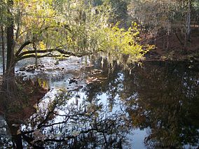
The Santa Fe River is a 75-mile (121 km) river in northern Florida. The watershed of the river is approximately 1,380 square miles (3,574 km2) and spreads across southern Columbia, southern Suwannee, western Bradford, far southern Baker, Union, northern and eastern Gilchrist, and northern Alachua counties. The headwaters of the river are Lake Santa Fe, near Keystone Heights. The Santa Fe River is usually a slow-flowing river. This slow speed, combined with the abundant leaf-drop from nearby trees, especially Bald Cypress, leads to a very dark-brown river due to dissolved tannins.
The Wakulla River is an 11-mile-long (18 km) river in Wakulla County, Florida. It carries the outflow from Wakulla Springs, site of the Edward Ball Wakulla Springs State Park, to the St. Marks River 3 miles (5 km) north of the Gulf of Mexico. Its drainage basin extends northwest into Leon County, including Munson Slough, and may extend as far north as the Georgia border.

The Sopchoppy River is a minor river in the Florida Big Bend. A tributary of the Ochlockonee River, it is approximately 46 miles (74 km) in length and nearly entirely within Wakulla County, with only a small part of its East Branch entering Leon County.

The Silver River is a short spring-fed river located east of Ocala in Marion County, Florida. Fed by Silver Springs, it connects the springs to the Ocklawaha River, passing through a pristine woodland environment. The river was probably named for its silvery appearance.

Backbone State Park is Iowa's oldest state park, dedicated in 1919. Located in the valley of the Maquoketa River, it is approximately three miles (5 km) south of Strawberry Point in Delaware County. It is named for a narrow and steep ridge of bedrock carved by a loop of the Maquoketa River originally known as the Devil's Backbone. The initial 1,200 acres (490 ha) were donated by E.M. Carr of Lamont, Iowa. Backbone Lake Dam, a relatively low dam built by the Civilian Conservation Corps (CCC) in the 1930s, created Backbone Lake. The CCC constructed a majority of trails and buildings which make up the park.
New River is a 31-mile-long (50 km) tributary of the Santa Fe River in northern Florida, United States. The river was used as the border to create Union County from Bradford County in 1921.

The John Gorrie Bridge carries US 98 and US 319 over the Apalachicola Bay. It connects Apalachicola, Florida, with Eastpoint, Florida. The original John Gorrie Bridge was built in 1935, replacing a ferry service between the two towns. It included a rotating section to allow passage of ships with high masts. The current bridge was built in 1988.
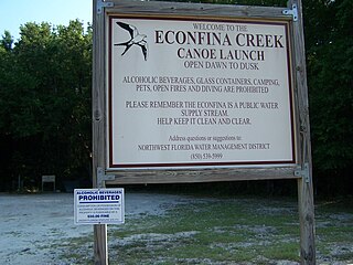
Econfina Creek is a small river in the middle Florida Panhandle. It flows through hilly country, and has sections of whitewater rapids. Much of its flow comes from springs. The river ends at Deer Point Lake, a reservoir that provides the freshwater supply for Panama City and much of Bay County.

Lacey-Keosauqua State Park is located southwest of Keosauqua, Iowa, United States. The park is located along the Des Moines River in Van Buren County. First dedicated in 1921, it is the largest state park in size in Iowa. In 1990, three areas were named nationally recognized historic districts and listed on the National Register of Historic Places.
Poe Springs is a spring about 3 miles west of High Springs, Florida. It is located in Poe Springs Park, which is 202 acres in size. The spring is isolated from the main part of the park at its center, requiring a 0.3 mile hike one-way. The water temperature is 72 degrees Fahrenheit. It is managed by Alachua County Parks and Recreation and is $5.00 per car to visit. Poe Springs Park is the only county-run park that allows swimming. In addition to swimming, snorkeling is also popular. However, scuba diving is not allowed. The spring produces an average volume of 45 million gallons of water daily that feed into the Santa Fe River. The spring vent is 25 feet deep.

Silver Glen Springs is a first-magnitude spring and the main attraction of the Silver Glen Springs Recreation Area of Ocala National Forest. It lies at the east edge of the national forest. It is about 2 miles north of the entrance of Juniper Creek, and it is along the edge of Big Scrub. There is a short spring run that is about 0.75 miles long and goes to Lake George.