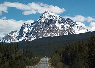
Mount Robson is the most prominent mountain in North America's Rocky Mountain range; it is also the highest point in the Canadian Rockies. The mountain is located entirely within Mount Robson Provincial Park of British Columbia, and is part of the Rainbow Range. Mount Robson is the second highest peak entirely in British Columbia, behind Mount Waddington in the Coast Range. The south face of Mount Robson is clearly visible from the Yellowhead Highway, and is commonly photographed along this route.

Mount Columbia is a mountain located in the Winston Churchill Range of the Rocky Mountains. It is the highest point in Alberta, Canada, and is second only to Mount Robson for height and topographical prominence in the Canadian Rockies. It is located on the border between Alberta and British Columbia on the northern edge of the Columbia Icefield. Its highest point, however, lies within Jasper National Park in Alberta.

Mumm Peak is located just north of Berg Lake at the northern end of Mount Robson Provincial Park, on the Alberta/British Columbia border. The peak lies on the common boundary shared by Jasper National Park and Mount Robson Provincial Park. It was named in 1910 by J. Norman Collie after Arnold L. Mumm (1859–1927), an English publisher and mountaineer who made the first ascent of this peak with Collie. The mountain is composed of sedimentary rock laid down during the Precambrian to Jurassic periods and pushed east and over the top of younger rock during the Laramide orogeny.

Caledonia Mountain is a 2,863-metre (9,393-foot) summit located in the Canadian Rockies on the shared border of Alberta and British Columbia in Canada. It is also situated along the shared boundary of Jasper National Park with Mount Robson Provincial Park. It ranks as the 59th most prominent mountain in Alberta. It was named in 1926 due to its location overlooking the Caledonian Valley.

Bastion Peak is a 2,994-metre (9,823 ft) mountain summit located on the shared border of Jasper National Park in Alberta, and Mount Robson Provincial Park in British Columbia, Canada. It is situated in the Tonquin Valley in the Canadian Rockies. It was named in 1916 by Édouard-Gaston Deville because it has an appearance similar to that of a bastion on a castle. Its nearest higher peak is Turret Mountain, 1.6 km (0.99 mi) to the west, and its greater parent is Mount Geikie 3 km (1.9 mi) to the west.

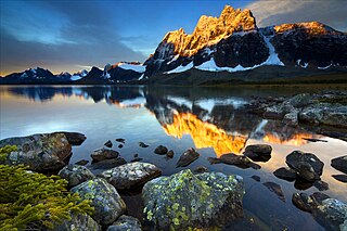
Redoubt Peak is a 3,115-metre (10,220 ft) mountain summit located on the shared border of Jasper National Park in Alberta, and Mount Robson Provincial Park in British Columbia, Canada. Redoubt Peak is part of The Ramparts in the Canadian Rockies. It was named in 1920 because it has an appearance similar to that of a redoubt on a castle. Its nearest higher peak is Dungeon Peak, 0.6 km (0.37 mi) to the southeast.
Dungeon Peak is a 3,129-metre (10,266 ft) mountain summit located on the shared border of Jasper National Park in Alberta, and Mount Robson Provincial Park in British Columbia, Canada. Dungeon Peak is part of The Ramparts in the Tonquin Valley. The descriptive name was applied in 1916 by Morrison P. Bridgland (1878-1948), a Dominion Land Surveyor who named many peaks in Jasper Park and the Canadian Rockies. The mountain's name was made official in 1935 by the Geographical Names Board of Canada.

Overlander Falls is a waterfall on the Fraser River in Mount Robson Provincial Park, British Columbia, Canada. It is popular for kayakers. The falls are reached by a short walking trail which starts on the Yellowhead Highway 2 km (1.2 mi) east of the Mount Robson visitor centre. The waterfall is named for the Overlanders expedition of 1862. A group of 175 men and 1 woman from Ontario travelled across the prairies and through the Rocky Mountains, intending to reach the Barkerville or Cariboo goldfields. Just west of Overlander Falls, the group split. About half continued down the Fraser River, eventually reaching Barkerville in late fall of 1862, but over a year had elapsed since Billy Barker's gold strike and there were no claims left to stake. The other half abandoned their dreams of gold and rafted down the North Thompson River to Fort Kamloops.

Rearguard Mountain is a 2,744-metre (9,003-foot) summit located within Mount Robson Provincial Park in British Columbia, Canada. It is part of the Rainbow Range which is a sub-range of the Canadian Rockies. Its nearest higher peak is Mount Robson, 4.0 km (2.5 mi) to the southwest. Rearguard is situated between Berg Lake and the Robson Glacier.

Mount Fitzwilliam is a 2,901-metre (9,518-foot) mountain summit located in the Canadian Rockies within Mount Robson Provincial Park in British Columbia, Canada. Mount Fitzwilliam is situated 6.0 km (3.7 mi) south of Yellowhead Pass and 4.0 km (2.5 mi) west of the Continental Divide, near the headwaters of the Fraser River. Its nearest higher peak is Roche Noire, 8.5 km (5.3 mi) to the east. Mt. Fitzwilliam is a prominent landmark seen from eastbound Highway 16 before travelers enter Jasper National Park from the west entrance. The mountain is also visible to riders on the Canadian train.

Cinnamon Peak is a 2,727-metre (8,947-foot) mountain summit located in the northwestern part of Mount Robson Provincial Park, in the Canadian Rockies of British Columbia, Canada. It is situated immediately north of the confluence of the Robson River and the Fraser River, and is visible from the Yellowhead Highway near the park's visitor centre. The peak was labelled "Little Grizzly" on Arthur Oliver Wheeler's 1911 topographic map of Mount Robson. He thought it appeared similar to Mount Grizzly in the Selkirk Mountains, but the name was later changed to Cinnamon, which is the coloration of the peak and the Cinnamon bear, which can be easily mistaken for a grizzly bear. "Little Grizzly" is a colloquial term for the black bear, Ursus americanus. Eastern populations are typically black in color, however western populations can be cinnamon colored. The mountain's toponym was officially adopted in 1951 by the Geographical Names Board of Canada. The nearest higher peak is Whitehorn Mountain, 6.0 km (3.7 mi) to the north.

Mica Mountain is a 2,855-meter-elevation (9,367-foot) mountain summit located in British Columbia, Canada.

Mount Wardle is a 2,805-metre (9,203-foot) mountain summit located in British Columbia, Canada.

Mount Verendrye is a 3,086-metre (10,125-foot) mountain summit located in British Columbia, Canada.

North Albert Peak is a 2,934-metre (9,626-foot) mountain summit located in British Columbia, Canada.

Mount Head is a 2,782-metre (9,127-foot) mountain summit located in Alberta, Canada.

Mount Ogden is a mountain in the Canadian Rockies of British Columbia, Canada.

Klapperhorn Mountain is a summit in British Columbia, Canada.

Mount Anne-Alice is a mountain summit in the Canadian Rockies of British Columbia, Canada.

Mount Carr is a 2,590-metre (8,497-foot) mountain summit located in British Columbia, Canada.


