Pike o' Blisco

Last updated

Pike o' Blisco
Pike O'Blisco.jpg
Pike o' Blisco from the ridge of Wet Side Edge, between the Three Shire Stone and Great Carrs
Highest point
Elevation 705 m (2,313 ft)
Prominence 177 m (581 ft)
Parent peak Scafell Pike
Listing Marilyn, Hewitt, Wainwright, Nuttall
Coordinates 54°25′41″N3°07′31″W / 54.42798°N 3.12519°W / 54.42798; -3.12519
Geography
Lake District National Park UK relief location map.png
Red triangle with thick white border.svg
Pike o' Blisco
Location in the Lake District
Location relief map Borough of Copeland.svg
Red triangle with thick white border.svg
Pike o' Blisco
Location in Copeland Borough
Location relief map United Kingdom South Lakeland.svg
Red triangle with thick white border.svg
Pike o' Blisco
Location in South Lakeland
Location Cumbria, England
Parent range Lake District, Southern Fells
OS grid NY271042
Topo map OS Landrangers 89, 90, Explorer OL6

Pike o' Blisco, or Pike of Blisco, is a mountain in the Lake District in Cumbria, England. Located between the valleys of Great Langdale and Little Langdale, its relative isolation from neighbouring fells together with slopes falling away immediately from the summit in all directions mean it has excellent views: the view of the Langdale Pikes across Great Langdale is particularly arresting.

Contents

The name Pike of Blisco is the form used on Ordnance Survey maps. The influential guidebook writer Alfred Wainwright preferred Pike o' Blisco (he refers to Pike of Blisco as its "Sunday name"), and wrote, "the man has no blood in his veins who does not respond eagerly to its fine-sounding, swashbuckling name". [1]

Topography

Pike o' Blisco stands on the complex ridge of high ground descending south-eastward from the Scafell massif. The ridge incorporates Esk Pike, Bow Fell, Crinkle Crags and Cold Pike before turning sharply north-eastward to Pike o' Blisco; it then makes a further abrupt northerly diversion around Blea Tarn to connect to Lingmoor Fell. To the north of Pike o' Blisco is the Oxendale branch of Great Langdale, while Little Langdale stands to the south east. The two valleys drain eastward, joining beyond Lingmoor Fell. To the south of Pike o' Blisco is the 393-metre (1,289-foot) summit of Wrynose Pass, which links Little Langdale with the Duddon Valley, and beyond the pass lies Swirl How and the Coniston Fells.

Between Cold Pike and Pike o' Blisco is a wide grassy depression at 528 metres (1,730 ft). On the southern side is the source of the River Duddon, while to the north is Red Tarn, a feeder of Great Langdale Beck. Red Tarn is an elongated pool whose stony bed can be seen through clear shallow waters, reputed to hold trout. Its name comes from the colour of the surrounding soil rather than the water itself. [2] The tarn forms a focal point for walkers, as the wide path from the summit of Wrynose Pass to Great Langdale runs beside it, with a further path branching off across its outflow towards Crinkle Crags. The main path was originally made to serve Red Crag Mine, which now consists of a series of pits and trial borings for iron ore, concentrated about 300 metres (980 ft) north of the tarn. The mine was worked from 1860 to 1875 but never achieved commercial success. [3]

Pike o' Blisco itself consists of the steep, conical summit area above Red Tarn along with a swathe of hilly country spreading out to the south and east. The summit is defended by Kettle Crag to the north and Black Wars to the west, with Black Crag abreast the ridge descending southward to Wrynose Pass. The eastern part of the fell is centred upon the subsidiary top of Blake Rigg at around 530 metres (1,740 ft) in an area of rocky outcrops and small tarns. From Blake Rigg a ridge runs north east to cross the summit of the Blea Tarn road at 224 metres (735 ft). This pass, narrow and steep even by Lake District standards, links the two Langdales and is named after the large tarn which sits beneath the eastern crags of Blake Rigg. Its waters hold trout, perch and pike, and the easily accessible shoreline features in many a photograph of the Langdale Pikes. [2]

The summit cairn in 2005. Blisco summit cairn.jpg
The summit cairn in 2005.

Geology

The interbedded volcaniclastic sandstone, tuff and lapilli-tuff of the Blisco Member predominate, with an intrusion of rhyolite running across the eastern slopes. [4]

Summit

Unusually for Lake District fells, Pike o' Blisco's summit is clearly visible from the valley below, in this case Great Langdale. (Consequently, a good view of the valley may be obtained from the summit. [5] ) Before 1959 the summit was crowned with a tall, conical cairn which could be seen from the valley, but between 1958 and 1959 it was apparently vandalised. [1] It has subsequently been rebuilt, although it does not appear as tall today as it does in Wainwright's 1958 drawing.

Ascent routes

There are two distinct routes to the summit from the popular walkers' resort of Dungeon Ghyll at the head of Great Langdale. One goes via Stool End farm at the foot of Bowfell; from here it follows the public footpath over the Oxendale Beck and up to Red Tarn, at around 525 metres (1,720 ft) above sea level, before ascending Pike o' Blisco's steep west face. The other route, which takes a generally more even gradient, climbs the mountain's east face using a path that starts from the Little Langdale road. [6]

It is also possible to climb Pike o' Blisco from Little Langdale, via a public footpath from Wrynose Bridge on the road to Wrynose Pass, about 2 km (1+14 mi) from the head of the valley. An alternative route from this direction, recommended by Wainwright, involves scrambling up a gully in the crags above the valley head, then walking across pathless terrain to the summit. The easiest route of ascent, however, is from the Three Shire Stone at the head of the Wrynose Pass, where vehicles may be parked at 393 metres (1,290 ft).

Pike o' Blisco is often climbed as a circuit around the head of Great Langdale incorporating Crinkle Crags and Bowfell, sometimes extended to include Rossett Pike and even the Langdale Pikes.

Related Research Articles

<span class="mw-page-title-main">Bowfell</span> Mountain in the English Lake District, Cumbria, England

Bowfell is a pyramid-shaped mountain lying at the heart of the English Lake District, in the Southern Fells area. It is the sixth-highest mountain in the Lake District and one of the most popular of the Lake District fells for walkers. It is listed in Alfred Wainwright's 'best half dozen' Lake District fells.

<span class="mw-page-title-main">Crinkle Crags</span> Mountain in the English Lake District, Cumbria, England

Crinkle Crags is a fell in the English Lake District in the county of Cumbria. It forms part of two major rings of mountains, surrounding the valleys of Great Langdale and Upper Eskdale. The name reflects the fell's physical appearance as its summit ridge is a series of five rises and depressions (crinkles) that are very distinctive from the valley floor. In Old English, cringol means twisted or wrinkled.

<span class="mw-page-title-main">Cold Pike</span> Fell in the Lake District, Cumbria, England

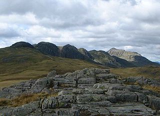
Cold Pike is a fell in the English Lake District. It is a satellite of Crinkle Crags and stands above the Upper Duddon Valley.

<span class="mw-page-title-main">High Raise (Langdale)</span> Mountain in the English Lake District, Cumbria, England

High Raise is a fell in the Central Fells of the English Lake District, not to be confused with another High Raise situated in the Far Eastern Fells. High Raise is one of the most spectacular mountains in the district; with a height of 762 metres (2,500 ft) it is the highest point in the central fells of Lakeland.

<span class="mw-page-title-main">Great Langdale</span> Valley in Cumbria, England

Great Langdale is a valley in the Lake District National Park in North West England, the epithet "Great" distinguishing it from the neighbouring valley of Little Langdale. Langdale is also the name of a valley in the Howgill Fells, elsewhere in Cumbria.

<span class="mw-page-title-main">Pike of Stickle</span> Mountain in the English Lake District, Cumbria, England

Pike of Stickle, also known as Pike o’ Stickle, is a fell in the English Lake District. It reaches a height of 709 metres (2,326 ft) and is situated in the central part of the national park in the valley of Great Langdale. The fell is one of three fells which make up the picturesque Langdale Pikes, one of the best-known areas in Lakeland. A "stickle" is a hill with a steep prominent rocky top, while a "pike" is a hill with a peaked summit, the name being therefore partly tautological.

<span class="mw-page-title-main">Furness Fells</span>

The Furness Fells are a multitude of hills and mountains in the Furness region of Cumbria, England. Historically part of Lancashire, the Furness Fells or High Furness is the name given to the upland part of Furness, that is, that part of Furness lying north of the line between Ulverston and Ireleth. The hills lie largely within the English Lake District.

<span class="mw-page-title-main">Thunacar Knott</span> Fell in the Lake District, Cumbria, England

Thunacar Knott is a fell in the central part of the English Lake District in the county of Cumbria.

<span class="mw-page-title-main">Sergeant Man</span>

Sergeant Man is a fell in the English Lake District. It is properly a secondary summit of High Raise, but is given a separate chapter by Alfred Wainwright in his third Pictorial Guide nonetheless, as it "is so prominent an object and offers so compelling a challenge". Its rocky cone is indeed in great contrast to the grassy dome of High Raise.

<span class="mw-page-title-main">Dow Crag</span> Fell in the Lake District, Cumbria, England

Dow Crag is a fell in the English Lake District near Coniston, Cumbria. The eastern face is one of the many rock faces in the Lake District used for rock climbing.

<span class="mw-page-title-main">Ullscarf</span> Fell in England

Ullscarf is a fell in the English Lake District close to the geographical centre of the Cumbrian hills. It forms part of the watershed between the Derwentwater and Thirlmere catchments, a ridge running broadly north-south.

Blea Rigg is a fell in the English Lake District, lying between the valleys of Easedale and Great Langdale. One of the Central Fells, it is a broad plateau with a succession of rocky tops. Many routes of ascent are possible, beginning either from Grasmere or Great Langdale, though the paths are often poorly marked and hard to follow.

<span class="mw-page-title-main">Lingmoor Fell</span> Fell in the Lake District, Cumbria, England

Lingmoor Fell is a fell in the English Lake District, situated eight kilometres west of Ambleside. The fell reaches a height of 469 m (1,540 ft) and divides the valleys of Great Langdale and Little Langdale. The fell's name originates from the Old Norse word lyng meaning “heather covered”. The actual summit of the fell is named as Brown How on Ordnance Survey maps.

<span class="mw-page-title-main">Swirl How</span> Fell in the Lake District, Cumbria, England

Swirl How is a fell in the English Lake District. It stands between Coniston and the Duddon Valley in the southern part of the District. It rivals the Old Man of Coniston as the highest point within the traditional County Palatine of Lancashire.

<span class="mw-page-title-main">Great Carrs</span> Fell in the Lake District, Cumbria, England

Great Carrs is a fell in the English Lake District. It stands above Wrynose Pass in the southern part of the District.

The Central Fells are a part of the Cumbrian Mountains in the Lake District of England. Reaching their highest point at High Raise, they occupy a broad area to the east of Borrowdale. The Central Fells are generally lower than the surrounding hills, the Lake District's dome-like structure having a slight dip in the middle. The range extends from the boggy ridge between Derwentwater and Thirlmere in the north, to the rock peaks of the Langdale Pikes in the south.

<span class="mw-page-title-main">Southern Fells</span>

The Southern Fells are a part of the Cumbrian Mountains in the Lake District of England. Including Scafell Pike, the highest peak in England, they occupy a broad area to the south of Great Langdale, Borrowdale and Wasdale. High and rocky towards the centre of the Lake District, the Southern Fells progressively take on a moorland character toward the south-west. In the south-east are the well-known Furness Fells, their heavily quarried flanks rising above Coniston Water.

References

  1. 1 2 Wainwright, A (2003) [1960]. A Pictorial Guide to the Lakeland Fells , Book 4: The Southern Fells. London: Frances Lincoln Publishers.
  2. 1 2 Blair, Don: Exploring Lakeland Tarns: Lakeland Manor Press (2003): ISBN   0-9543904-1-5
  3. Adams, John: Mines of the Lake District Fells: Dalesman (1995) ISBN   0-85206-931-6
  4. British Geological Survey: 1:50,000 series maps, England & Wales Sheet 38: BGS (1998)
  5. "View from Pike of Blisco". Viewfinder Panoramas. Archived from the original on 10 August 2022.
  6. Richards, Mark: Mid-Western Fells: Collins (2004): ISBN   0-00-711368-4