Each tehsil has its Tehsildar, who is the administrative head. The district is further divided into eleven blocks: Poonch, Mandi, Loran, Sathra, Mendhar, Mankote, Balakote, Surankote, and Buffliaz.[9] The administrative head of each block is the Block Development Officer (BDO). Each block consists of a number of panchayats. Poonch district has a total of 179 villages.
Economy
The local economy depends on agriculture. Industrial environment is absent and commercial activity exists on a very low scale. Peoples have small pieces of land for cultivation of fruits and crops. In 2006, the Ministry of Panchayati Raj named Poonch one of the country's 250 most backward districts (out of a total of 640).[10] It is one of the three districts in Jammu and Kashmir currently receiving funds from the Backward Regions Grant Fund Programme (BRGF).[10]
[11] The current MLAs of Poonch Haveli and Mendhar are Ajaz Ahmed Jan and Javed Ahmed Rana of the JKNC. While Surankote is represented by Independent politician Choudhary Mohammad Akram.
According to the 2011 census Poonch district, India has a population of 476,835,[13] roughly equal to the nation of Suriname.[14] This gives it a ranking of 548th in India (out of a total of 640). The district has a population density of 285 inhabitants per square kilometre (740/sqmi). Its population growth rate over the decade 2001-2011 was 27.97%. Poonch has a sex ratio of 893 females for every 1000 males (which varies with religion),[13] and a literacy rate of 68.69%. 8.10% of the population lives in urban areas. The Scheduled Castes and Scheduled Tribes account for 0.12% and 36.93% of the population of the district.[15] The district is 90.45% Muslim.[13]
Religion
As of 2011[update], the proportions of different religions in the district were as follows: Islam (90.45%), Hinduism (6.84%), Sikhism (2.35%), Christianity (0.20%), not stated (0.15%), and others (0.02%).[13]
Only 8.1% of the district's population lived in urban areas. The proportions of religions in urban areas differed from the district as a whole, being: Islam (51.38%), Hinduism (32.82%), Sikhism (14.62%), Christianity (0.96%), not stated (0.20%), and others (0.03%).[13]
Poonch district: religion, gender ratio, and% urban of population, according to the 2011 Census.[13]
Hindu
Muslim
Christian
Sikh
Buddhist
Jain
Other
Not stated
Total
Total
32,604
431,279
958
11,188
83
10
2
711
476,835
6.84%
90.45%
0.20%
2.35%
0.02%
0.00%
0.00%
0.15%
100.00%
Male
23,684
220,636
614
6,497
76
5
1
386
251,899
Female
8,920
210,643
344
4,691
7
5
1
325
224,936
Gender ratio (% female)
27.4%
48.8%
35.9%
41.9%
8.4%
50.0%
50.0%
45.7%
47.2%
Sex ratio (no. of females per 1,000 males)
377
955
560
722
–
–
–
842
893
Urban
12,677
19,848
371
5,647
8
3
0
76
38,630
Rural
19,927
411,431
587
5,541
75
7
2
635
438,205
% Urban
38.9%
4.6%
38.7%
50.5%
9.6%
30.0%
0.0%
10.7%
8.1%
Sex Ratio in Poonch District in 2011 Census.[13] (no. females per 1,000 males)
There is no railway connectivity to Poonch yet. There are plans to build the Jammu–Poonch line in the near future to connect Poonch with Jammu.[18] The nearest major railway station is Jammu Tawi railway station which is located 235 kilometres from district headquarters Poonch.
Road
Poonch district is connected to the summer capital Jammu by the NH 144A alongside other intra-district roads. It also has road connectivity with Srinagar through the picturesque Mughal Road. There are plans to upgrade the existing NH 144A to four-lane for faster movement of traffic.[19] A bus across the LOC, the Poonch–Rawalakot Bus has helped to re-establish ties across the border.
Education
The urban area has both govt and private schools but the no of govt schools is significantly higher in rural areas. Most of the govt schools have a MDM(MID DAY MEAL) of nutritious food on a regular basis. The city also has a college named Shri Krishan Chander degree college Poonch offering bachelor courses in fields of humanities, science, commerce, languages, etc. Most schools are affiliated to JKBOSE, whereas schools having CBSE, and ICSE boards are also there.
Tourism
Poonch is well known for its tourism across the country. It has the famous, Budda amarnath temple located in Mandi zone. Other places which are well known are Ziarat Sain Miran Sahib, LOC Trade Centre, Mughal Road & Pir ki Gali, Than Pir, Noori chammb waterfall, Nandishool Waterfall, Poonch view(Mountain Top). Every year in the month of August, a yatra known as chhadi yatra takes place in which people from all over India travel to the city and join the yatra to seek blessings.
The annual Shri BudhaAmarnath Ji Yatra remains a significant religious pilgrimage in Poonch, drawing thousands of devotees from across India. Despite intermittent cross-border shelling and civilian casualties caused by Pakistaniartillery, the pilgrimage continues with full support from the administration, security forces, and religious organizations. The BudhaAmarnath Ji Mela and associated spiritual events are held each year with elaborate arrangements to ensure the safety and well-being of pilgrims.[20]
Food
The city is known for its delicious vegetarian, non-vegetarian and vegan cuisines. Most people here follow a non-vegetarian diet, followed by lacto-ovo-vegetarian, lacto-vegetarian diet. People here follow diet due to personal, cultural, or religious reasons. Various non-vegetarian restaurants serve finger-licking delicious meat dishes of kashmiri cuisine. People here eat a variety of meat like poultry, mutton, lamb, beef, fish and lean meats. The city also serves few vegetarian and vaishnav food in various restaurants. Most fast foods are non-vegetarian. Since the majority is Muslim, halal meat is available in abundance.
Battle of Poonch (1971)
The famous Battle of Poonch, also known as Defence of Poonch, was fought here in 1971. This battle, which lasted from December 3 - December 16, was a pivotal defensive operation on the Western Front of the India-Pakistan war of 1971, where Indian forces successfully thwarted a major Pakistani offensive aimed at capturing the strategically vital town of Poonch.[21]
Pakistan sought to capture Poonch to isolate Indian forces in Jammu and Kashmir and gain a bargaining chip for negotiations. The main assault occurred between December 3 and December 6, 1971, following Pakistan's pre-emptive air strikes on Indian airfields. The defense by Indian Forces was led by the 93 Infantry Brigade, commanded by Brigadier Anant Vishwanath Natu. Key units included the 6th Sikh Battalion,[22] supported by the 8th Jat Regiment, and the 195 Mountain Regiment (Artillery). Pakistan deployed a division-sized force of approximately eight battalions (two brigades), including the 5th Frontier Force Rifles and the 51st Punjab Regiment.
The assault started on December 3. Pakistan launched heavy artillery shelling followed by infantry attacks on Indian forward piquets, specifically targeting heights like Durga, Banwat, and Doda. A critical engagement took place at the Poonch helipad, where Indian troops, including two platoons under Captain Mamik, held firm against overwhelming numbers. After blunting the initial Pakistani push by December 10, Indian forces launched a counter-attack on the night of December 10–11, capturing the strategic Nangi Tekri feature.
The Indian Army successfully defended Poonch without losing a single post. Pakistan suffered significant losses, with an estimated 322 killed and 761 wounded. The 6th Sikh Battalion was awarded the Battle Honour "Defence of Poonch 1971". Brigadier A.V. Natu and Lt Col K.L. Rattan (Commanding Officer of 6 Sikh) were awarded the Maha Vir Chakra (MVC) for their leadership. By holding Poonch, India secured its lines of communication in the sector, preventing a potential collapse of its defenses in Jammu and Kashmir.
2025 Artillery Shelling
On 7 May 2025, Pakistan launched a significant artillery offensive along the Line of Control (LoC) in response to India's Operation Sindoor. The Pakistani shelling resulted in the deaths of at least 15 Indian civilians and injured 43 others, with areas like Poonch and Rajouri being heavily affected.[23]
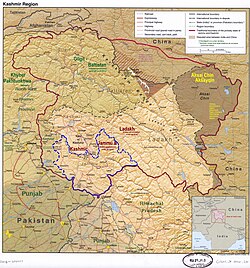
123 The application of the term "administered" to the various regions of Kashmir and a mention of the Kashmir dispute is supported by the tertiary sources (a) through (d), reflecting due weight in the coverage. Although "controlled" and "held" are also applied neutrally to the names of the disputants or to the regions administered by them, as evidenced in sources (f) through (h) below, "held" is also considered politicized usage, as is the term "occupied," (see (i) below). (a) Kashmir, region Indian subcontinent, Encyclopaedia Britannica, retrieved 15 August 2019 (subscription required) Quote: "Kashmir, region of the northwestern Indian subcontinent ... has been the subject of dispute between India and Pakistan since the partition of the Indian subcontinent in 1947. The northern and western portions are administered by Pakistan and comprise three areas: Azad Kashmir, Gilgit, and Baltistan, the last two being part of a territory called the Northern Areas. Administered by India are the southern and southeastern portions, which constitute the state of Jammu and Kashmir but are slated to be split into two union territories."; (b) Pletcher, Kenneth, Aksai Chin, Plateau Region, Asia, Encyclopaedia Britannica, retrieved 16 August 2019 (subscription required) Quote: "Aksai Chin, Chinese (Pinyin) Aksayqin, portion of the Kashmir region, at the northernmost extent of the Indian subcontinent in south-central Asia. It constitutes nearly all the territory of the Chinese-administered sector of Kashmir that is claimed by India to be part of the Ladakh area of Jammu and Kashmir state."; (c) "Kashmir", Encyclopedia Americana, Scholastic Library Publishing, 2006, p.328, ISBN978-0-7172-0139-6 C. E Bosworth, University of Manchester Quote: "KASHMIR, kash'mer, the northernmost region of the Indian subcontinent, administered partlv by India, partly by Pakistan, and partly by China. The region has been the subject of a bitter dispute between India and Pakistan since they became independent in 1947"; (d) Osmańczyk, Edmund Jan (2003), Encyclopedia of the United Nations and International Agreements: G to M, Taylor & Francis, pp.1191–, ISBN978-0-415-93922-5 Quote: "Jammu and Kashmir: Territory in northwestern India, subject to a dispute betw een India and Pakistan. It has borders with Pakistan and China." (e) Talbot, Ian (2016), A History of Modern South Asia: Politics, States, Diasporas, Yale University Press, pp.28–29, ISBN978-0-300-19694-8 Quote: "We move from a disputed international border to a dotted line on the map that represents a military border not recognized in international law. The line of control separates the Indian and Pakistani administered areas of the former Princely State of Jammu and Kashmir."; (f) Kashmir, region Indian subcontinent, Encyclopaedia Britannica, retrieved 15 August 2019 (subscription required) Quote: "... China became active in the eastern area of Kashmir in the 1950s and has controlled the northeastern part of Ladakh (the easternmost portion of the region) since 1962."; (g) Bose, Sumantra (2009), Kashmir: Roots of Conflict, Paths to Peace, Harvard University Press, pp.294, 291, 293, ISBN978-0-674-02855-5 Quote: "J&K: Jammu and Kashmir. The former princely state that is the subject of the Kashmir dispute. Besides IJK (Indian-controlled Jammu and Kashmir. The larger and more populous part of the former princely state. It has a population of slightly over 10 million, and comprises three regions: Kashmir Valley, Jammu, and Ladakh.) and AJK ('Azad" (Free) Jammu and Kashmir. The more populous part of Pakistani-controlled J&K, with a population of approximately 2.5 million. AJK has six districts: Muzaffarabad, Mirpur, Bagh, Kodi, Rawalakot, and Poonch. Its capital is the town of Muzaffarabad. AJK has its own institutions, but its political life is heavily controlled by Pakistani authorities, especially the military), it includes the sparsely populated "Northern Areas" of Gilgit and Baltistan, remote mountainous regions which are directly administered, unlike AJK, by the Pakistani central authorities, and some high-altitude uninhabitable tracts under Chinese control." (h) Fisher, Michael H. (2018), An Environmental History of India: From Earliest Times to the Twenty-First Century, Cambridge University Press, p.166, ISBN978-1-107-11162-2 Quote: "Kashmir's identity remains hotly disputed with a UN-supervised “Line of Control” still separating Pakistani-held Azad (“Free”) Kashmir from Indian-held Kashmir."; (i) Snedden, Christopher (2015), Understanding Kashmir and Kashmiris, Oxford University Press, p.10, ISBN978-1-84904-621-3 Quote:"Some politicised terms also are used to describe parts of J&K. These terms include the words 'occupied' and 'held'."
A. V. Dwivedi; Ayushi. "The Punchi Language: A Typological Sketch". In N. S. Dash; S. Arulmozi; N. Ramesh (eds.). Handbook on Endangered South Asian and Southeast Asian Languages. Cham: Springer. pp.91–118. doi:10.1007/978-3-031-80752-7_5.
This page is based on this Wikipedia article Text is available under the CC BY-SA 4.0 license; additional terms may apply. Images, videos and audio are available under their respective licenses.